Page 177 of 221

11
AUDIO EQUIPMENT and TELEMATICSEQUIPMENT and TELEMA
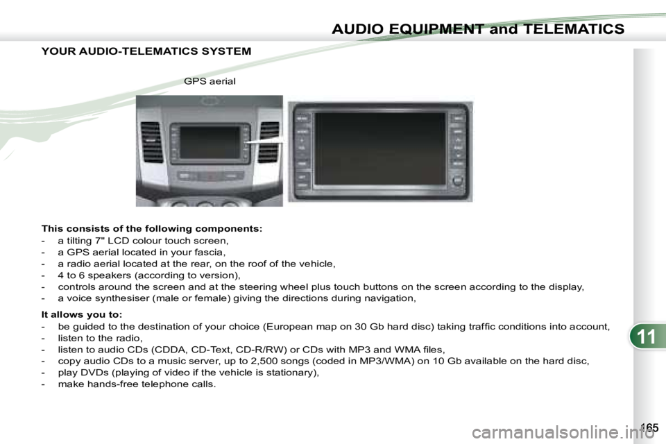
YOUR AUDIO-TELEMATICS SYSTEM
This consists of the following components:
- a tilting 7" LCD colour touch screen,
- a GPS aerial located in your fascia,
- a radio aerial located at the rear, on the roof of the vehicle,
- 4 to 6 speakers (according to version),
- controls around the screen and at the steering wheel plu s touch buttons on the screen according to the display,
- a voice synthesiser (male or female) giving the directions duri ng navigation,
It allows you to:
- b e g u i d e d t o t h e d e s t i n a t i o n o f y o u r c h o i c e ( E u r o p e a n m a p o n 3 0 G b h a r d d i s c ) t a k i n g t r a f fi c c o n d i t i o n s i n t o a c c o u n t ,
- listen to the radio,
- l i s t e n t o a u d i o C D s ( C D D A , C D - T e x t , C D - R / R W ) o r C D s w i t h M P 3 a n d W M A fi l e s ,
- copy audio CDs to a music server, up to 2,500 songs (coded i n MP3/WMA) on 10 Gb available on the hard disc,
- play DVDs (playing of video if the vehicle is stationary),
- make hands-free telephone calls. GPS aerial
Page 178 of 221

11
AUDIO EQUIPMENT and TELEMATICS
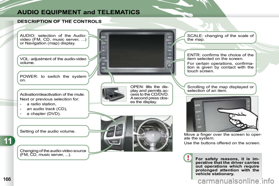
AUDIO: selection of the Audio-
video (FM, CD, music server, ...)
or Navigation (map) display.
VOL: adjustment of the audio-video
volume. OPEN: tilts the dis-
play and permits ac-
cess to the CD/DVD.
A second press clos-
es the display. SCALE: changing of the scale of
the map.
E N T R : c o n fi r m s t h e c h o i c e o f t h e
item selected on the screen.
F o r c e r t a i n o p e r a t i o n s , c o n fi r m a -
tion is given by contact with the
touch screen.
Scrolling of the map displayed or
selection of an item.
For safety reasons, it is im-
perative that the driver carries
out operations which require
prolonged attention with the
vehicle stationary.
DESCRIPTION OF THE CONTROLS DESCRIPTION OF THE CONTROLS
Changing of the audio-video source
(FM, CD, music server, ...).
Activation/deactivation of the mute.
Next or previous selection for:
- a radio station,
- an audio track (CD),
- a chapter (DVD).
M o v e a fi n g e r o v e r t h e s c r e e n t o o p e r -
ate the system.
Use the buttons offered on the screen.
POWER: to switch the system
on.
Setting of the audio volume.
Page 179 of 221

11
EQUIPMENT and TELEMA
DESCRIPTION OF THE CONTROLS - MENUS DESCRIPTION OF THE CONTROLS - MENUS
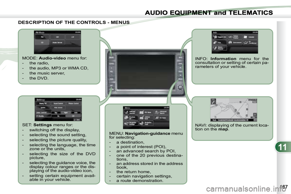
MODE: Audio-video menu for:
- the radio,
- the audio, MP3 or WMA CD,
- the music server,
- the DVD.
MENU: Navigation-guidance menu
for selecting:
- a destination,
- a point of interest (POI),
- an advanced search by POI,
- one of the 20 previous destina- tions,
- an address stored in the address book,
- the return home,
- certain navigation settings,
- a route demonstration. NAVI: displaying of the current loca-
tion on the
map .
SET:
Settings menu for:
- switching off the display,
- selecting the sound setting,
- selecting the picture quality,
- selecting the language, the time zone or the units,
- selecting the size of the DVD picture,
- selecting the guidance voice, the display colour ranges or the dis-
playing of the audio-video icon,
- setting certain equipment avail- able in your vehicle. INFO:
Information menu for the
consultation or setting of certain pa-
rameters of your vehicle.
Page 180 of 221

11
AUDIO EQUIPMENT and TELEMATICS
NAVIGATION-GUIDANCE NAVIGATION-GUIDANCE
GPS
What is the navigation system and
the GPS?
The satellite navigation system guides
the driver to the destination that he has
set in accordance with a chosen route.
Initially, it searches for the destination
required by the user, then it calculates
t h e r o u t e a n d fi n a l l y i t p r o v i d e s t h e v i -
sual and audible guidance instructions. What precautions should be
observed in order to use the system
under good conditions?
Do not place anything on or near the
GPS aerial.
Do not use any digital communication
equipment (personal computers, etc.)
near the GPS aerial.
D o n o t a f fi x a n y r e fl e c t i v e fi l m s o r fi l m s
containing carbon to the window.
The system’s measurements may be
inaccurate if the vehicle is:
- in a tunnel or underground car
park,
- underneath a two-level motorway,
- in an area with several very high buildings,
- surrounded by closely planted trees.
Depending on the vehicle’s situation
and the reception of the GPS informa-
tion, the displayed information may dis-
appear from the display temporarily.
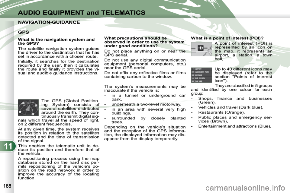
The GPS (Global Position-
ing System) consists of
several satellites distributed
around the earth. They con-
tinuously transmit digital sig-
nals which travel at the speed of light,
on 2 different frequencies.
At any given time, the system receives
its position in relation to the satellites
detected and the time of transmission
of the signal.
This enables the telematic unit to de-
duce its position and therefore that of
the vehicle.
A repositioning process using the map
database stored on the hard disc per-
mits repositioning of the vehicle’s po-
sition on the road network in order to
improve the accuracy of the locating
function. What is a point of interest (POI)?
A point of interest (POI) is
represented by an icon on
the map, it represents an
airport, a station, a town
hall, …
Up to 40 different icons may
be displayed (refer to the
section "Points of interest
icon").
T h e y a r e c l a s s i fi e d i n 5 g r o u p s
a n d i d e n t i fi e d b y o n e c o l o u r f o r e a c h
group:
- S h o p s , fi n a n c e a n d b u s i n e s s e s (Green),
- Vehicles and travel (Dark blue),
- Restaurants (Orange),
- Public places and emergency ser- vices (Brown),
- Entertainment and attractions (Blue).
Page 181 of 221

11
K1K2K3
K4K5
K
H
E
F
BCA
D
G
I
J
AUDIO EQUIPMENT and TELEMATICSEQUIPMENT and TELEMA
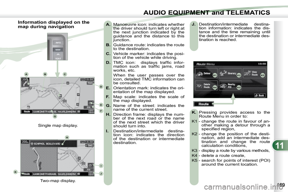
A. Manoeuvre icon: indicates whether
the driver should turn left or right at
the next junction indicated by the
guidance and the distance to this
junction.
B. Guidance route: indicates the route
to the destination.
C. Vehicle marker: indicates the posi-
tion of the vehicle while driving.
D. T M C i c o n : d i s p l a y s t r a f fi c i n f o r -
m a t i o n s u c h a s t r a f fi c j a m s , r o a d
works, etc.
When the user passes over the icon, detailed TMC information can
be consulted.
E. Orientation mark: indicates the ori-
entation of the map displayed.
F. Map scale: indicates the scale of
the map displayed.
G. Name of the street: indicates the
name of the current street.
H. Direction frame: displays the num-
ber of the next road or the name
of the next street which the driver
should turn into.
I. Destination/intermediate destina-
tion icon: indicates the direction
of the destination or intermediate
destination.
Two-map display.
Single map display.
Information displayed on the
map during navigation
J. Destination/intermediate destina-
tion information: indicates the dis-
tance and the time remaining until
the destination or intermediate des-
tination is reached.
K. Pressing provides access to the
Route Menu in order to:
K1 - change the route in favour of an- other making a detour through a
s p e c i fi e d r e g i o n ,
K2 - change the position of the desti- nation, add an intermediate des-
tination and change the route
calculation conditions,
K3 - display a route by various methods,
K4 - delete a route create,
K5 - search for points of interest (POI) around the current location.
Page 182 of 221

11
ABC
A4
A3
A2
A1
A6
A5
B1
B2
B3
B4
B5
C1C2C3
C4C5C6
C7C8
AUDIO EQUIPMENT and TELEMATICS
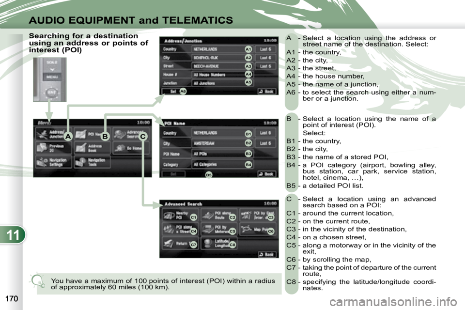
B - Select a location using the name of a point of interest (POI).
Select:
B1 - the country,
B2 - the city,
B3 - the name of a stored POI,
B4 - a POI category (airport, bowling alley, bus station, car park, service station,
hotel, cinema, …),
B5 - a detailed POI list.
C - Select a location using an advanced search based on a POI:
C1 - around the current location,
C2 - on the current route,
C3 - in the vicinity of the destination,
C4 - on a chosen street,
C5 - along a motorway or in the vicinity of the exit,
C6 - by scrolling the map,
C7 - taking the point of departure of the current route,
C8 - specifying the latitude/longitude coordi- nates.
A - Select a location using the address or
street name of the destination. Select:
A1 - the country,
A2 - the city,
A3 - the street,
A4 - the house number,
A5 - the name of a junction,
A6 - to select the search using either a num- ber or a junction.
You have a maximum of 100 points of interest (POI) within a ra dius
of approximately 60 miles (100 km).
Searching for a destination
using an address or points of
interest (POI)
Page 183 of 221
11
E2E1E3
DEF
AUDIO EQUIPMENT and TELEMATICSEQUIPMENT and TELEMA
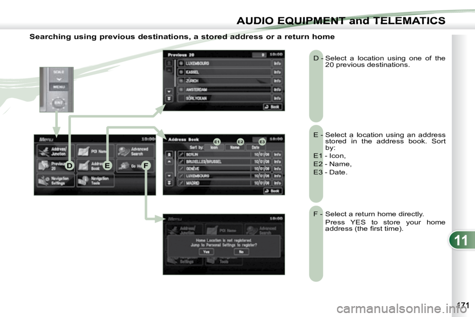
Searching using previous destinations, a stored address or a return home
E - Select a location using an address stored in the address book. Sort
by:
E1 - Icon,
E2 - Name,
E3 - Date.
D - Select a location using one of the
20 previous destinations.
F - Select a return home directly.
Press YES to store your home a d d r e s s ( t h e fi r s t t i m e ) .
Page 184 of 221

11
GH
G1G2G3
G4G5
H1H2
H3H4
AUDIO EQUIPMENT and TELEMATICS
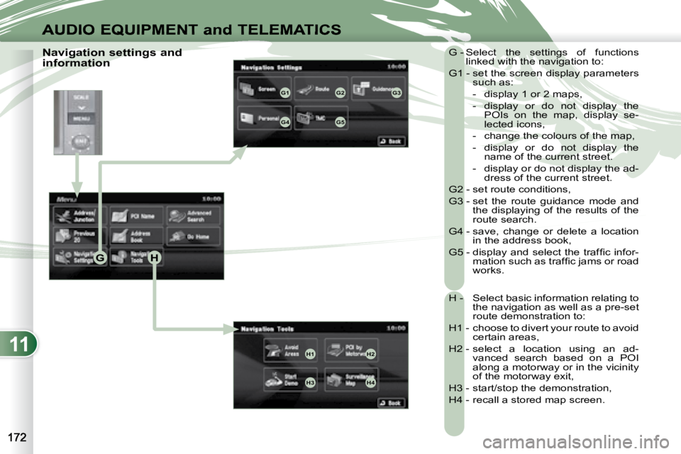
Navigation settings and
information G - Select the settings of functions
linked with the navigation to:
G1 - set the screen display parameters such as:
- display 1 or 2 maps,
- display or do not display the POIs on the map, display se-
lected icons,
- change the colours of the map,
- display or do not display the name of the current street.
- display or do not display the ad- dress of the current street.
G2 - set route conditions,
G3 - set the route guidance mode and the displaying of the results of the
route search.
G4 - save, change or delete a location in the address book,
G 5 - d i s p l a y a n d s e l e c t t h e t r a f fi c i n f o r - m a t i o n s u c h a s t r a f fi c j a m s o r r o a d
works.
H - Select basic information relating to the navigation as well as a pre-set
route demonstration to:
H1 - choose to divert your route to avoid certain areas,
H2 - select a location using an ad- vanced search based on a POI
along a motorway or in the vicinity
of the motorway exit,
H3 - start/stop the demonstration,
H4 - recall a stored map screen.