Page 65 of 135

65
Button Description
These settings determine how routes will be calculated. Select the type of vehicle you are driving, the road types used in route
planning, and the route planning method.
If more drivers use MMES for navigating, their settings can be remembered by using one of the user profiles.
You can fine-tune the appearance of the Map screen. Adjust the map view to your needs, choose suitable color themes from the
list for both daytime and night use, turn track logging on or off, and manage you Place visibility sets (which Places to show on
the map).
Adjust how the software helps you navigate with different kinds of route related information on the Map screen.
Display related settings.
These settings allow you to customize the application for your local language, measurement units, time and date settings and
formats, as well as to choose the time zone.
Trip logs and track logs contain useful information about your trips. Trip logs can be saved manually when you reach your
destination or you can turn on the automatic saving here.
The application collects usage information and GPS logs that may be used for improving the application and the quality and
coverage of maps. Here you can enable or disable collecting these logs.
Modify the basic software parameters set during the initial setup process.
For details, see page 10.
205-0010-00_QY-7375M-A_EN.indb 65205-0010-00_QY-7375M-A_EN.indb 653/12/2013 9:57:24 AM3/12/2013 9:57:24 AM
Page 66 of 135

66
q
Sound and Warnings
Button Description
Tap this button to adjust the volume of the voice guidance.
This button shows the current voice guidance profile. By tapping the button, you can select a new profile from the list of available
languages.
Tap any of these to hear a sample voice prompt. Just tap
when you have selected the new spoken
language.
Information for the next turn is given shortly before you make it. With this setting, you can also receive information for the next
turn shortly after you make the previous turn.
Tap this button to set the verbosity of the voice instructions:
Verbose: Guide 3 times before the applicable intersection.
Compact: Guide 2 times before the applicable intersection.
Minimal: Guide 1 time just before the applicable intersection.
Note that the number of guidances may vary depending on the route.
Maps may contain information about the speed limits of the road segments. MMES is able to warn you if you exceed the current
limit. This information may not be available for your region, or may not be fully correct for all roads in the map.
This setting lets you decide whether you wish to receive visible and/or audible warnings.
Adjust the slider to set the relative speed above which the application initiates the warning.
The following alert types are available:
Audio warning: you receive a verbal warning when you exceed the speed limit with the given percentage.
Visual warning: the current speed limit is shown on the map when you exceed it.
If you prefer to see the speed limit sign on the map all the time (normally it is shown only if your speed exceeds it), you can set it
here.
205-0010-00_QY-7375M-A_EN.indb 66205-0010-00_QY-7375M-A_EN.indb 663/12/2013 9:57:24 AM3/12/2013 9:57:24 AM
Page 67 of 135

67
Button Description
This feature allows you to receive a warning when approaching alert points like school zones or railroad crossings. You must
ensure on your own liability that using this feature is legal in the country where you intend to use it.
You can set the alert for the different alert point categories individually. The following alert types are available:
Audio warning: beeps can be played by natural voice while you are approaching one of these points, and an extra alert can
warn you if you exceed the given speed limit while approaching.
Visual warning: the type of the alert point, its distance and the related speed limit appear on the Map screen while you are
approaching one of these.
For some of the alert points, the enforced or expected speed limit is available. For these points, the audio alert can be different if
you are below or above the given speed limit.
Only when speeding: The audio alert is only played when you exceed the given speed limit.
When approaching: The audio alert is always played when approaching one of these alert points. In order to draw your
attention, the alert is different when you exceed the speed limit.
Maps may contain driver alert information. Tap this button to turn on or off these warnings and to set the distance from the
hazard to receive the warning at. These can be set individually for the different warning types.
q
Customize Quick menu
The content of the Quick menu (page 25) is fully customizable. Tap the button you want to change, and select its new function from the list.
The list of available functions and their descriptions are on page 26.
205-0010-00_QY-7375M-A_EN.indb 67205-0010-00_QY-7375M-A_EN.indb 673/12/2013 9:57:24 AM3/12/2013 9:57:24 AM
Page 68 of 135

68
q
Route settings
These settings determine how routes will be calculated.
Button Description
Some parameters of your car can be set. These are taken into account in route calculation.
On-road navigation creates a turn by turn itinerary using the road network on the map. Switch to off-road navigation to navigate
between destinations in a straight line.
The route calculation can be optimized for different situations by changing the planning method. See below for details.
To let the route fit your needs, you can also set which road types are to be considered for or to be excluded from the route if possible.
Excluding a road type is a preference. It does not necessarily mean total prohibition. If your destination can only be accessed using some of the
excluded road types, they will be used but only as much as necessary. In this case a warning icon will be shown on the My Route screen, and the part
of the route not matching your preference will be displayed in a different color on the map.
In the list of road types you can see in how many segments and what total length of the road type is used in the current route.
Button Description
You might need to avoid freeways when you are driving a slow car or you are towing another vehicle.
Charge roads are pay roads where you can purchase a pass or vignette to use the road for a longer period of time. They can be
enabled or disabled separately from toll roads.
MMES includes toll roads (pay roads where there is a per-use charge) in the routes by default. If you disable toll roads, MMES
plans the best toll-free route.
MMES includes ferries in a planned route by default. However, a map does not necessarily contain information about the
accessibility of temporary ferries. You might also need to pay a fare on ferries.
MMES excludes unpaved roads by default: unpaved roads can be in a bad condition and usually you cannot reach the speed
limit on them.
If the selected routing method is not Green, you can have your route compared to the best green alternative on the screen when
confirming the route. If this alternative is much better than the selected method, you can quickly switch to Green mode.
205-0010-00_QY-7375M-A_EN.indb 68205-0010-00_QY-7375M-A_EN.indb 683/12/2013 9:57:24 AM3/12/2013 9:57:24 AM
Page 69 of 135

69
Route Planning Method types:
Button Description
Gives a quick route if you can travel at or near the speed limit on all roads. Usually the best selection for fast and normal cars.
Gives a quick but fuel-efficient route based on the fuel consumption data given in Route settings. Travel cost and CO2 emission
calculations are estimations only. They cannot take elevations, curves and traffic conditions into account.
Gives a short route to minimize the distance to travel. It can be practical for slow vehicles. Searching for a short route regardless
of the speed, this route type is rarely practical for normal vehicles.
Results in a route with fewer turns and no difficult maneuvers. With this option, you can make MMES to take, for example, the
freeway instead of a series of smaller roads or streets.
qUser profiles
If more drivers use MMES for navigating, their settings can be remembered by using one of the user profiles. Rename the profiles after tapping the edit
button on the right so that all users know which profile to use and switch between profiles by tapping its name. If you select a new profile, the application
restarts so that the new settings can take effect.
205-0010-00_QY-7375M-A_EN.indb 69205-0010-00_QY-7375M-A_EN.indb 693/12/2013 9:57:24 AM3/12/2013 9:57:24 AM
Page 70 of 135

70
q
Map settings
You can fine-tune the appearance of the Map screen. Adjust the map view to your needs, choose suitable color themes from the list for both daytime
and night use, show or hide 3D buildings, turn track logging on or off, and manage you Place visibility sets (which Places to show on the map).
The map is always shown on the screen so that you can see the effect when you change a setting.
Button Description
Switch the map view between a 3D perspective view and a 2D top-down view.
Adjust the basic zoom and tilt levels to your needs. Three levels are available.
When selected, the map zooms out to show an overview of the surrounding area if the next route event (maneuver) is far. When
you get close to the event, the normal map view returns.
Switch between daytime and night color modes or let the software switch between the two modes automatically a few minutes
before sunrise and a few minutes after sunset.
Select the color scheme used in daytime mode.
Select the color scheme used in night mode.
Show or suppress 3D landmarks, 3D artistic or block representations of prominent or well-known objects.
Show or suppress 3D city models, 3D artistic or block representation of full city building data containing actual building size and
position on the map. This is the optional content and you need to add to use.
205-0010-00_QY-7375M-A_EN.indb 70205-0010-00_QY-7375M-A_EN.indb 703/12/2013 9:57:24 AM3/12/2013 9:57:24 AM
Page 71 of 135

71
Button Description
Show or suppress the 3D elevation of the surrounding terrain.
Turn on or off track log saving, that is, saving the sequence of the locations your journeys go through.
Select which Places to show on the map while navigating. Too many Places make the map crowded so it is a good idea too
keep as few of them on the map as possible. For this, you have the possibility to save different Place visibility sets. You have the
following possibilities:
Tap the checkbox to show or hide the Place category.
Tap the name of the Place category to open the list of its subcategories.
to save the current Place visibility set or to load a previously saved one. Here you can also revert to
the default visibility settings.
q
Visual guidance settings
Adjust how the software helps you navigate with different kinds of route related information on the Map screen.
Button Description
The data fields in the corner of the Map screen can be customized. Tap this button and select the values you want to see. The
values can be different when you navigate a route from when you are just cruising without a given destination. The 3 data fields
on the left are displayed in the Map screen. For each field, you can select general trip data like your current speed or route data
related to your final destination from the list on the right.
205-0010-00_QY-7375M-A_EN.indb 71205-0010-00_QY-7375M-A_EN.indb 713/12/2013 9:57:24 AM3/12/2013 9:57:24 AM
Page 72 of 135

72
Button Description
You may need a gas station or a restaurant during your journey. This feature displays a new button on the map when you are
driving on freeways. Tap this button to open a panel with the details of the next few exits or service stations. Tap any of them to
display it on the map and add it as a waypoint to your route if needed.
Select the service types displayed for the freeway exists. Choose from the POI categories.
Whenever adequate information is available, lane information similar to the real ones on road signs above the road is displayed
at the top of the map. You can turn this feature on or off.
If you are approaching a freeway exit or a complex intersection and the needed information exists, the map is replaced with a
3D view of the junction. You can turn this feature on or let the map be displayed for the whole route.
When entering tunnels, the surface roads and buildings can be disturbing. This feature shows a generic picture of a tunnel
instead of the map. A top-down overview of the tunnel and remaining distance are also displayed.
Turn on the route progress bar to see your route as a straight line on the left side of the map. The red arrow represents your
current position and moves up as you travel. Waypoints are also displayed on the line.
When you slow down while driving on a freeway, there is a chance that you are in a traffic jam so MMES offers you a detour
using the next exit. The message shows you distance of the exit and the difference in distance and estimated time compared to
the original route. You can choose from one of the following options:
Tap Dismiss or just ignore the message if you want to keep the original route.
Tap Preview to see the overview of the original route and the detour to make the decision. You can accept the detour as
offered or increase the bypassed freeway segment before accepting.
Turn to the suggested new direction and the route will be automatically recalculated.
Similar to the above possibility, alternative routes can be suggested when driving on normal roads. MMES will select a different
turn in the upcoming intersection and offers you a different route for the next section of the route.
Your options are the similar as above but you cannot modify the offered detour.
Parking at the destination may not be easy in city areas. As you approach the destination, MMES can offer parking category
Places near your destination. Tap the “P” button to open a top-down map with the destination and the offered parking Places.
Select one and modify the route accordingly.
If you leave the recommended route and suddenly exit the freeway, the application offers different alternatives near the exit like
gas stations or restaurants. Also, if there are avoidable parts of the original route ahead (like a tunnel, a toll road or a ferry), you
will find them in the list in case you want to bypass them with the help of MMES.
205-0010-00_QY-7375M-A_EN.indb 72205-0010-00_QY-7375M-A_EN.indb 723/12/2013 9:57:24 AM3/12/2013 9:57:24 AM
 1
1 2
2 3
3 4
4 5
5 6
6 7
7 8
8 9
9 10
10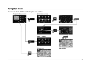 11
11 12
12 13
13 14
14 15
15 16
16 17
17 18
18 19
19 20
20 21
21 22
22 23
23 24
24 25
25 26
26 27
27 28
28 29
29 30
30 31
31 32
32 33
33 34
34 35
35 36
36 37
37 38
38 39
39 40
40 41
41 42
42 43
43 44
44 45
45 46
46 47
47 48
48 49
49 50
50 51
51 52
52 53
53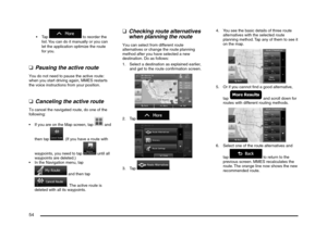 54
54 55
55 56
56 57
57 58
58 59
59 60
60 61
61 62
62 63
63 64
64 65
65 66
66 67
67 68
68 69
69 70
70 71
71 72
72 73
73 74
74 75
75 76
76 77
77 78
78 79
79 80
80 81
81 82
82 83
83 84
84 85
85 86
86 87
87 88
88 89
89 90
90 91
91 92
92 93
93 94
94 95
95 96
96 97
97 98
98 99
99 100
100 101
101 102
102 103
103 104
104 105
105 106
106 107
107 108
108 109
109 110
110 111
111 112
112 113
113 114
114 115
115 116
116 117
117 118
118 119
119 120
120 121
121 122
122 123
123 124
124 125
125 126
126 127
127 128
128 129
129 130
130 131
131 132
132 133
133 134
134