Page 105 of 436

operation. As a result, you may have to drive
for some time until precise route guidance
takes place.
GPS Reception
The correct functioning of the navigation
system is also dependent on the GPS
reception. In certain situations, the GPS
reception may be impaired, distorted or even
impossible, e.g. in tunnels, multi-storey car
parks or due to snow on the GPS antenna. If
there is snow on the GPS antenna, you should
remove it. The GPS antenna is at the rear on
the vehicle's roof.
Route Guidance after Vehicle Transport
After vehicle transport (e.g. by ferry, car train
or by towing) COMAND must determine the
vehicle location again.
Position finding takes place automatically
when the vehicle is driven off again, even if
COMAND is switched off. The actual length of
time may vary from case to case.
While the vehicle is determining its position,
route guidance is subject to the following
restrictions:
R Navigation announcements, route
guidance displays and displayed street
names do not match the actual location.
R COMAND does not issue any navigation
announcements.
R The message Off Mapped Road and a
direction arrow are displayed instead of the
route guidance displays. The arrow
indicates the direction of the destination.
i Direction arrow accuracy is also
dependent on correct vehicle position
and/or direction.
Once the position finding operation has been
completed, route guidance takes place again
via navigation announcements and route
guidance displays.
Interrupting Journey during Route
Guidance
i An interruption in the journey means
parking the vehicle and switching off the
vehicle.
The continuation of the journey means
switching the vehicle on again and
continuing to drive.
If you interrupt the journey during route
guidance and continue it later, the following
applies:
R If you continue the journey within 2 hours,
COMAND automatically continues route
guidance.
R If you continue the journey after 2 hours,
route guidance is canceled. You will have
to continue the canceled route guidance
again manually ( Y page 137).
Measurement Units
The measurement units displayed in
navigation mode are identical to those set in
the instrument cluster.
Menu Overview
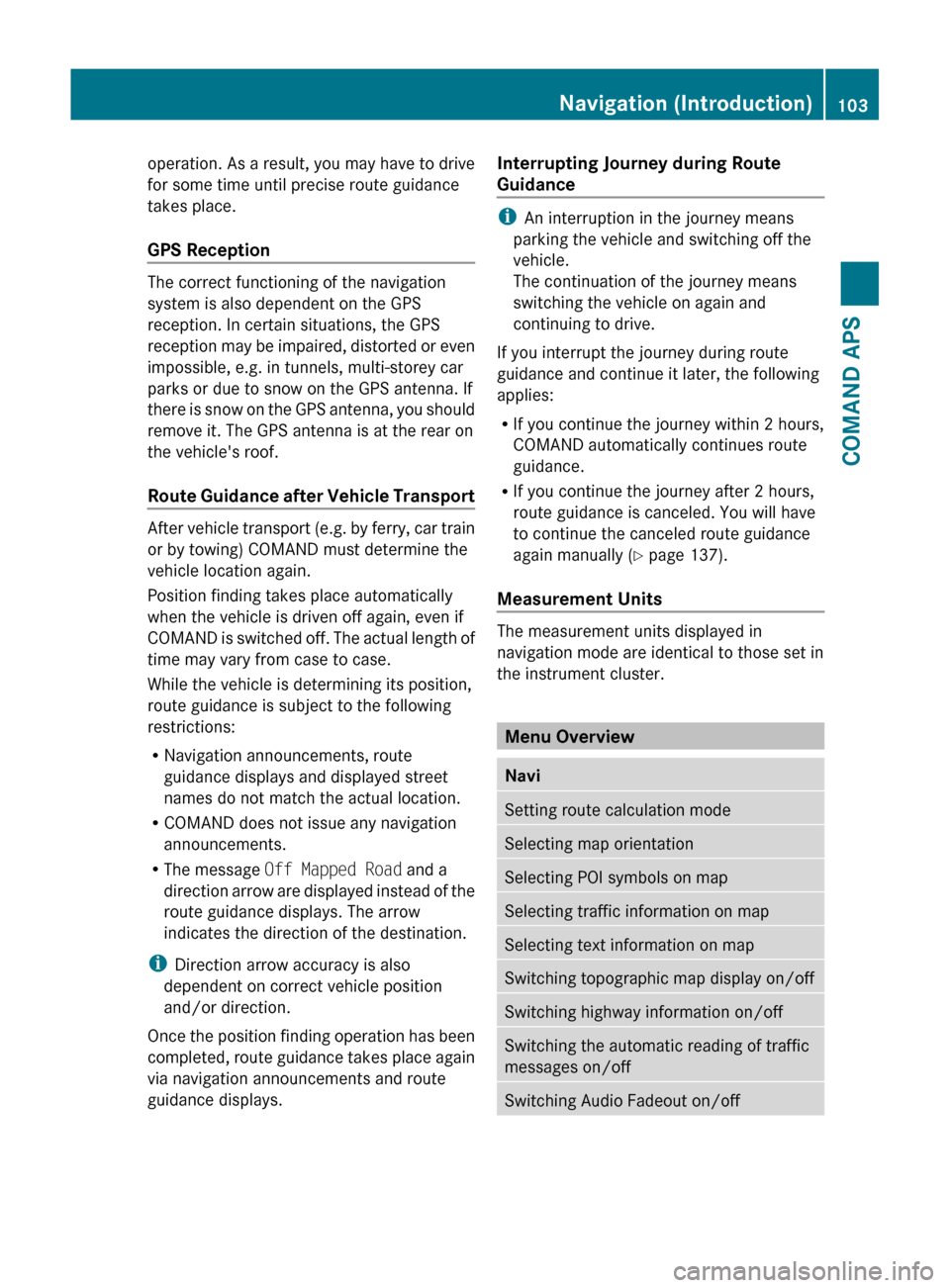
NaviSetting route calculation modeSelecting map orientationSelecting POI symbols on mapSelecting traffic information on mapSelecting text information on mapSwitching topographic map display on/offSwitching highway information on/offSwitching the automatic reading of traffic
messages on/offSwitching Audio Fadeout on/offNavigation (Introduction)103COMAND APSBA 197 USA, CA Edition A 2011; 1; 27, en-UShereepeVersion: 3.0.3.52010-03-24T15:31:10+01:00 - Seite 103Z
Page 106 of 436
NaviSetting Block AreaSIRIUS Service104Navigation (Introduction)COMAND APS
BA 197 USA, CA Edition A 2011; 1; 27, en-UShereepeVersion: 3.0.3.52010-03-24T15:31:10+01:00 - Seite 104
Page 107 of 436

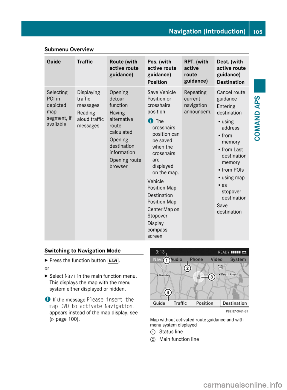
Submenu OverviewGuideTrafficRoute (with
active route
guidance)
Pos. (with
active route
guidance)
Position
RPT. (with
active
route
guidance)
Dest. (with
active route
guidance)
Destination
Selecting
POI in
depicted
map
segment, if
available
Displaying
traffic
messages
Reading
aloud traffic
messages
Opening
detour
function
Having
alternative
route
calculated
Opening
destination
information
Opening route
browser
Save Vehicle
Position or
crosshairs
position
iThe
crosshairs
position can
be saved
when the
crosshairs
are
displayed
on the map.
Vehicle
Position Map
Destination
Position Map
Center Map on
Stopover
Display
compass
screen
Repeating
current
navigation
announcem.
Cancel route
guidance
Entering
destination
Rusing
address
Rfrom
memory
Rfrom Last
destination
memory
Rfrom POIs
Rusing map
Ras
stopover
destination
Save
destination
Switching to Navigation ModeXPress the function button Ø.
or
XSelect Navi in the main function menu.
This displays the map with the menu
system either displayed or hidden.
iIf the message Please insert the
map DVD to activate Navigation.
appears instead of the map display, see
(Y page 100).Map without activated route guidance and withmenu system displayed
1 Status line2 Main function lineNavigation (Introduction)105COMAND APSBA 197 USA, CA Edition A 2011; 1; 27, en-UShereepeVersion: 3.0.3.52010-03-24T15:31:10+01:00 - Seite 105Z
Page 108 of 436

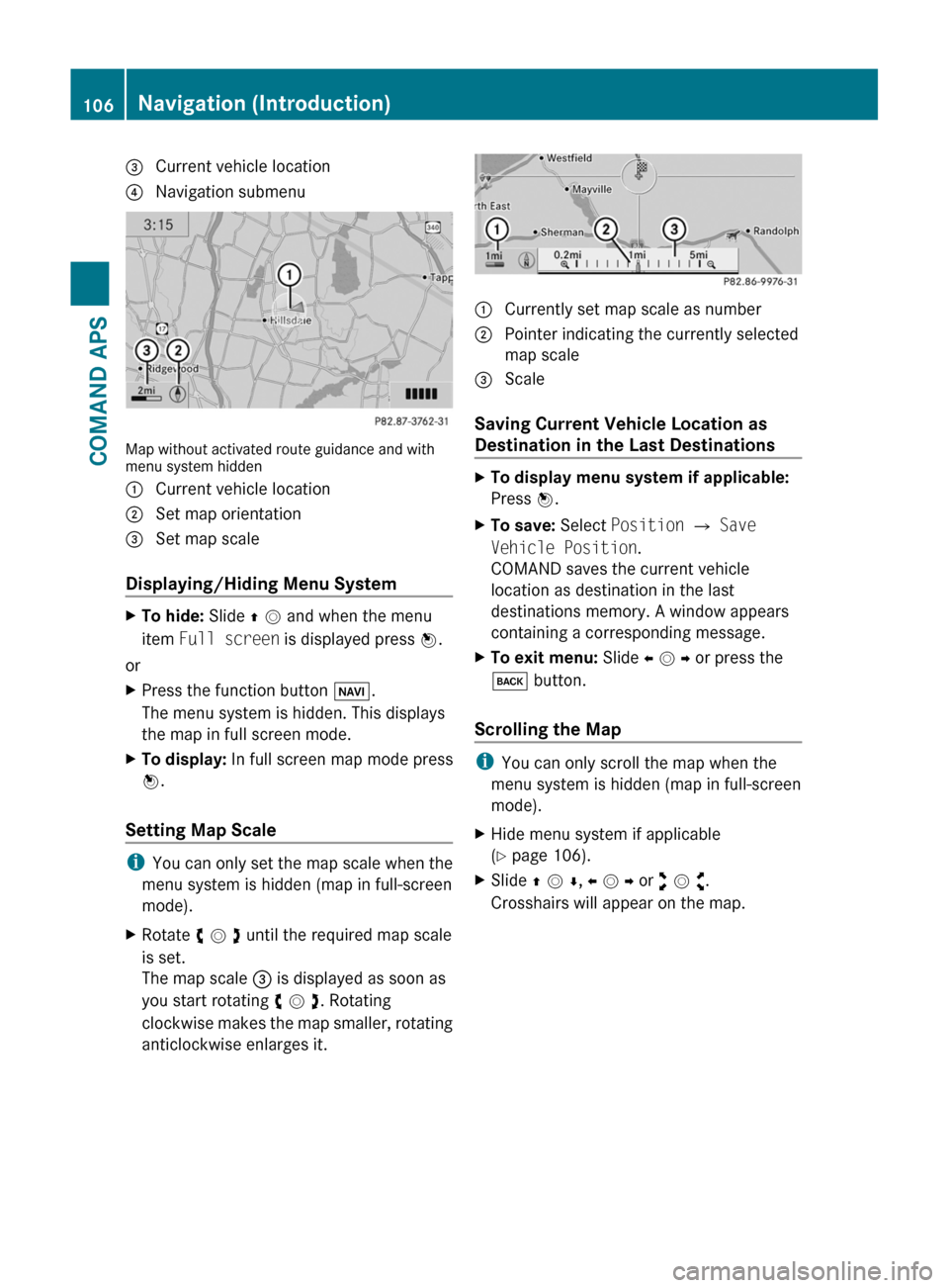
3 Current vehicle location4 Navigation submenu
Map without activated route guidance and withmenu system hidden
1 Current vehicle location2 Set map orientation3 Set map scale
Displaying/Hiding Menu System
XTo hide: Slide q m and when the menu
item Full screen is displayed press n.
or
XPress the function button Ø.
The menu system is hidden. This displays
the map in full screen mode.
XTo display: In full screen map mode press
n.
Setting Map Scale
iYou can only set the map scale when the
menu system is hidden (map in full-screen
mode).
XRotate y m z until the required map scale
is set.
The map scale 3 is displayed as soon as
you start rotating y m z. Rotating
clockwise makes the map smaller, rotating
anticlockwise enlarges it.
1 Currently set map scale as number2 Pointer indicating the currently selected
map scale
3 Scale
Saving Current Vehicle Location as
Destination in the Last Destinations
XTo display menu system if applicable:
Press n.
XTo save: Select Position £ Save
Vehicle Position.
COMAND saves the current vehicle
location as destination in the last
destinations memory. A window appears
containing a corresponding message.
XTo exit menu: Slide o m p or press the
k button.
Scrolling the Map
iYou can only scroll the map when the
menu system is hidden (map in full-screen
mode).
XHide menu system if applicable
(Y page 106).
XSlide q m r, o m p or w m x.
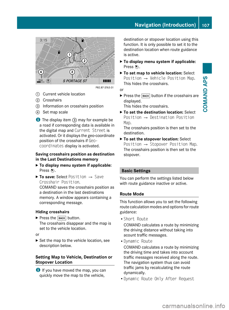
Crosshairs will appear on the map.
106Navigation (Introduction)COMAND APS
BA 197 USA, CA Edition A 2011; 1; 27, en-UShereepeVersion: 3.0.3.52010-03-24T15:31:10+01:00 - Seite 106
Page 109 of 436

1 Current vehicle location2 Crosshairs3 Information on crosshairs position4 Set map scale
iThe display item 3 may for example be
a road if corresponding data is available in
the digital map and Current Street is
activated. Or it displays the geo-coordinate
position of the crosshairs if Geo-
coordinates display is activated.
Saving crosshairs position as destination
in the Last Destinations memory
XTo display menu system if applicable:
Press n.
XTo save: Select Position £ Save
Crosshair Position.
COMAND saves the crosshairs position as
a destination in the last destinations
memory. A window appears containing a
corresponding message.
Hiding crosshairs
XPress the k button.
The crosshairs disappear and the map is
set to the vehicle location.
or
XSet the map to the vehicle location, see
description below.
Setting Map to Vehicle, Destination or
Stopover Location
iIf you have moved the map, you can
quickly move the map to the vehicle,
destination or stopover location using this
function. It is only possible to set it to the
destination location when route guidance
is active.
XTo display menu system if applicable:
Press n.
XTo set map to vehicle location: Select
Position £ Vehicle Position Map.
This hides the crosshairs.
or
XPress the k button if the crosshairs are
displayed.
This hides the crosshairs.
XTo set the destination location: Select
Position £ Destination Position
Map.
The crosshairs position is then set to the
destination.
XTo set the stopover location: Select
Position £ Stopover Position Map.
The crosshairs position is then set to the
stopover.
Basic Settings
You can perform the settings listed below
with route guidance inactive or active.
Route Mode
This function allows you to set the following
route calculation modes and options for route
guidance:
RShort Route
COMAND calculates a route by minimizing
the driving distance without taking into
acount traffic messages.
RDynamic Route
COMAND calculates a route by minimizing
the driving time and takes into account
traffic messages received along the route.
The navigation system thus can avoid
traffic jams by recalculating the route
dynamically.
RDynamic Route Only After Request
Navigation (Introduction)107COMAND APSBA 197 USA, CA Edition A 2011; 1; 27, en-UShereepeVersion: 3.0.3.52010-03-24T15:31:10+01:00 - Seite 107Z
Page 110 of 436

Same as Dynamic Route with the
exception that a message appears asking
you whether you want to allow the
rerouting or not.
RFast Route
COMAND calculates a route by minimizing
the driving time without taking into acount
traffic messages.
RAvoid Highways
RAvoid Toll Roads
RAvoid Tunnels
RAvoid Ferries
RAvoid AutoTrains
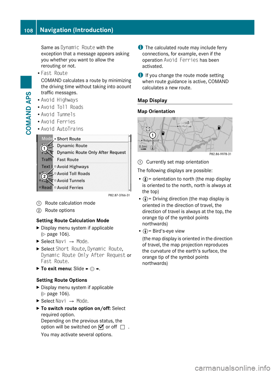
1 Route calculation mode; Route options
Setting Route Calculation Mode
XDisplay menu system if applicable
(Y page 106).
XSelect Navi £ Mode.XSelect Short Route, Dynamic Route,
Dynamic Route Only After Request or
Fast Route.
XTo exit menu: Slide o m p.
Setting Route Options
XDisplay menu system if applicable
(Y page 106).
XSelect Navi £ Mode.XTo switch route option on/off: Select
required option.
Depending on the previous status, the
option will be switched on Ç or offc.
You may activate several options.
iThe calculated route may include ferry
connections, for example, even if the
operation Avoid Ferries has been
activated.
iIf you change the route mode setting
when route guidance is active, COMAND
calculates a new route.
Map Display
Map Orientation
1 Currently set map orientation
The following displays are possible:
R9= orientation to north (the map display
is oriented to the north, north is always at
the top)
R8= Driving direction (the map display is
oriented in the direction of travel, the
direction of travel is always at the top, the
orange tip of the symbol points
northwards)
R8= Bird's-eye view
(the map display is oriented in the direction
of travel, the map projection reproduces
the curvature of the earth's surface, the
orange tip of the symbol points
northwards)
108Navigation (Introduction)COMAND APS
BA 197 USA, CA Edition A 2011; 1; 27, en-UShereepeVersion: 3.0.3.52010-03-24T15:31:10+01:00 - Seite 108
Page 111 of 436

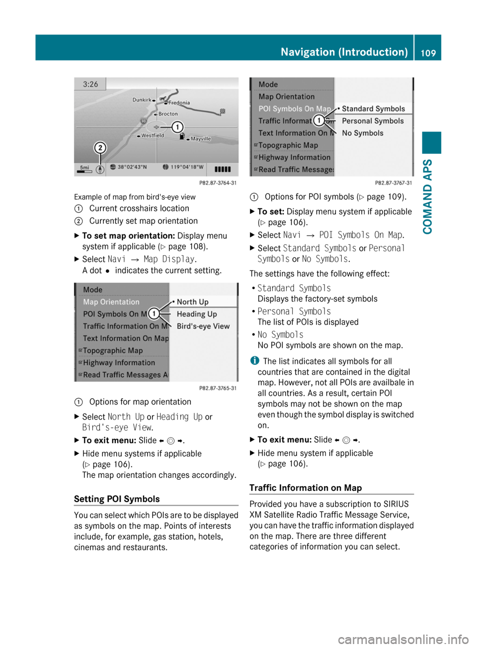
Example of map from bird's-eye view
1 Current crosshairs location2 Currently set map orientationXTo set map orientation: Display menu
system if applicable (Y page 108).
XSelect Navi £ Map Display.
A dotR indicates the current setting.
1 Options for map orientationXSelect North Up or Heading Up or
Bird's-eye View.
XTo exit menu: Slide o m p.XHide menu systems if applicable
(Y page 106).
The map orientation changes accordingly.
Setting POI Symbols
You can select which POIs are to be displayed
as symbols on the map. Points of interests
include, for example, gas station, hotels,
cinemas and restaurants.
1 Options for POI symbols (Y page 109).XTo set: Display menu system if applicable
(Y page 106).
XSelect Navi £ POI Symbols On Map.XSelect Standard Symbols or Personal
Symbols or No Symbols.
The settings have the following effect:
RStandard Symbols
Displays the factory-set symbols
RPersonal Symbols
The list of POIs is displayed
RNo Symbols
No POI symbols are shown on the map.
iThe list indicates all symbols for all
countries that are contained in the digital
map. However, not all POIs are availbale in
all countries. As a result, certain POI
symbols may not be shown on the map
even though the symbol display is switched
on.
XTo exit menu: Slide o m p.XHide menu system if applicable
(Y page 106).
Traffic Information on Map
Provided you have a subscription to SIRIUS
XM Satellite Radio Traffic Message Service,
you can have the traffic information displayed
on the map. There are three different
categories of information you can select.
Navigation (Introduction)109COMAND APSBA 197 USA, CA Edition A 2011; 1; 27, en-UShereepeVersion: 3.0.3.52010-03-24T15:31:10+01:00 - Seite 109Z
Page 112 of 436

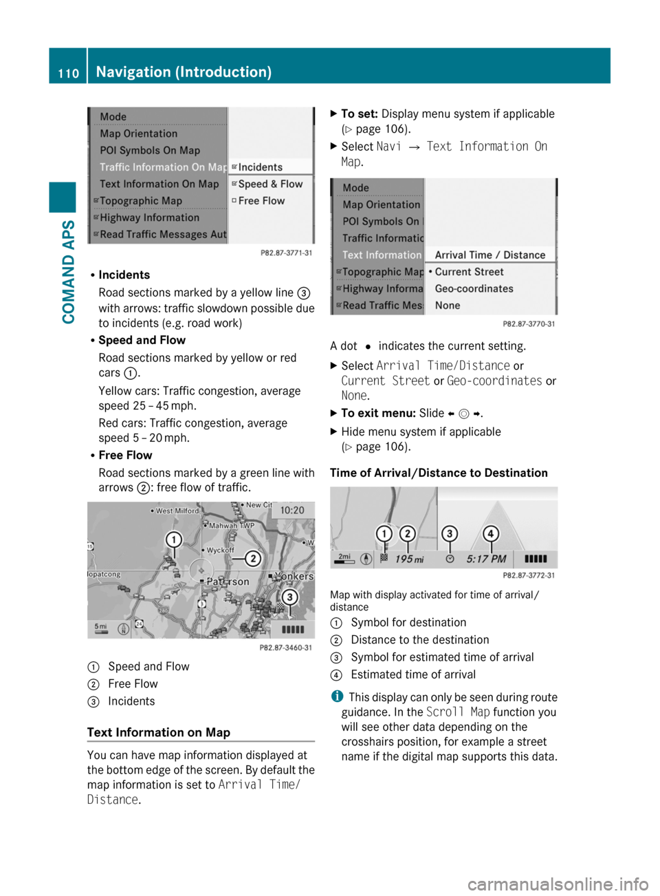
RIncidents
Road sections marked by a yellow line =
with arrows: traffic slowdown possible due
to incidents (e.g. road work)
RSpeed and Flow
Road sections marked by yellow or red
cars :.
Yellow cars: Traffic congestion, average
speed 25 – 45 mph.
Red cars: Traffic congestion, average
speed 5 – 20 mph.
RFree Flow
Road sections marked by a green line with
arrows ;: free flow of traffic.
1 Speed and Flow2 Free Flow3 Incidents
Text Information on Map
You can have map information displayed at
the bottom edge of the screen. By default the
map information is set to Arrival Time/
Distance.
XTo set: Display menu system if applicable
(Y page 106).
XSelect Navi £ Text Information On
Map.
A dot R indicates the current setting.
XSelect Arrival Time/Distance or
Current Street or Geo-coordinates or
None.
XTo exit menu: Slide o m p.XHide menu system if applicable
(Y page 106).
Time of Arrival/Distance to Destination
Map with display activated for time of arrival/distance
1 Symbol for destination2 Distance to the destination3 Symbol for estimated time of arrival4 Estimated time of arrival
iThis display can only be seen during route
guidance. In the Scroll Map function you
will see other data depending on the
crosshairs position, for example a street
name if the digital map supports this data.
110Navigation (Introduction)COMAND APS
BA 197 USA, CA Edition A 2011; 1; 27, en-UShereepeVersion: 3.0.3.52010-03-24T15:31:10+01:00 - Seite 110