Page 25 of 74
 - 2018 - crc - 7/12/17
24 Navigation
Map Types
.2-Dimensional (2D) View –The
2D map is a two-dimensional flat
repre")
Chevrolet City Express Infotainment System (GMNA-Localizing-U.S./Canada-
11683801) - 2018 - crc - 7/12/17
24 Navigation
Map Types
.2-Dimensional (2D) View –The
2D map is a two-dimensional flat
representation of the map data,
similar to a road map.
. 2-Dimensional (2DN) View –The
2DN map is a two-dimensional
representation of the map data,
similar to a road map, focused
on the vehicle’s position with the
top of the map aligned North.
. 3-Dimensional (3D) View –The
3D map displays the map from
an elevated perspective,
providing a panoramic view over
a long distance.
The map in 3D view always
appears with the current forward
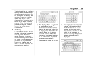
direction facing up (heading up). Display Information (2D, 2DN, or 3D)
1. Voice
Touch to repeat the voice
guidance while a route is
active. Touch and hold to
switch the voice guidance
on and off.
2. Audio information
Indicates the radio station,
CD track number, or other
audio information currently
playing.
3. Next maneuver
Indicates the name of the
next road in the route
guidance. This is only
shown if route guidance is
active.
4. Clock
Indicates the current time.
5. Direction indicator and
distance to next maneuver
on the route
Page 26 of 74
 - 2018 - crc - 7/12/17
Navigation 25
When route guidance is
active but the route has
been deviated from, this
area di")
Chevrolet City Express Infotainment System (GMNA-Localizing-U.S./Canada-
11683801) - 2018 - crc - 7/12/17
Navigation 25
When route guidance is
active but the route has
been deviated from, this
area displays a compass
icon with an arrow
indicating the destination
direction.
When route guidance is
active and on route, this
area indicates the distance
to the next point and the
turning direction at that
point.
6. Estimated time of arrivaland distance to destination
or remaining time of travel
and distance to destination
When touching this
selection, the indicator will
switch between estimated
arrival time and remaining
travel time.
This indicator only appears
once the destination is set
and the route guidance is
initiated.
7. Current road indicator
The location of where the
car is positioned.
8. Vehicle icon
Indicates the current
location and direction of the
vehicle.
9. Suggested route
Appears as a bold blue line
during route guidance.
10. Scale indicator
Indicates the scale of
the map.
11. Compass icon
Indicates the direction of
the map. When in 2D
mode, touching this icon
will switch the map view
between the North Up and
Heading Up modes.
12. Presets
This option switches On
and Off with APPS
hon
the center stack and shows
a menu of the radio presets
on the display.
13.VZoom in andUZoom
out icons
Touch to zoom the map in
or out. When zooming in or
out, the scale on the bottom
right side of the display
changes to indicate the new
scale level.
14. Options
Touch to access the map
options menu display.
To scroll the map in either direction: 1. Touch and release the display anywhere on the map.
2. Touch the display again and move your finger along the
display in the desired direction.
After releasing and touching the
map again, a marker will display at
the point touched and, if possible,
the position determined.
When the current location of the
vehicle is recognized, the street
name will be shown at the bottom of
the display. If the location is not
Page 27 of 74
 - 2018 - crc - 7/12/17
26 Navigation
recognized by the system,
coordinates corresponding to the
marker’s position w")
Chevrolet City Express Infotainment System (GMNA-Localizing-U.S./Canada-
11683801) - 2018 - crc - 7/12/17
26 Navigation
recognized by the system,
coordinates corresponding to the
marker’s position will be displayed.
Returning to the Current Vehicle
Location
The basic map view displays the
current location of the vehicle. The
current location can be displayed
again even after the map is moved,
or after the Menu is displayed.
Press MAP or BACK on the center
stack and the current location
displays on the map.
Map Options Menu Display
The Map Options menu allows you
to quickly store the current position,
show position information or
destination information, and adjust
the map settings. 1. Touch Options while the route guidance map is displayed.
2. The following options areavailable for selection:
.Enter Destination
Touch to open the
navigation display or enter
an address.
. Turn List
Touch to display all of the
turns and waypoints along
the route.
. Cancel Route
Touch to cancel the entire
route or waypoints along
the route.
. POIs Along Route Select to choose the types
of points of interest to
display along the active
route. Available options are
gas stations, restaurants,
ATMs, parking, rest areas,
hotels, dealerships, and
airports.
. SiriusXM Traffic
Select to display all traffic
events on route and options
to avoid roads along the
route.
. Show Route On Map
Select to show the entire
route on the display. The
view will zoom to the
necessary level in order to
show both the starting point
and destination on the
display.
. Routing Options
Touch to view options
available to the customized
route. Specific roads,
dynamic guidance, route
Page 28 of 74
 - 2018 - crc - 7/12/17
Navigation 27
type, use of freeways, types
of roads, and use of ferries
can all be adjusted.
.")
Chevrolet City Express Infotainment System (GMNA-Localizing-U.S./Canada-
11683801) - 2018 - crc - 7/12/17
Navigation 27
type, use of freeways, types
of roads, and use of ferries
can all be adjusted.
. Show Position Information
Touch to display the
latitude, longitude, and
altitude for the current
position of the vehicle.
Location can also the
stored to the Address Book.
. Show Waypoints
Touch to add or show a list
of waypoints along the
route.
. Guidance & Map Settings
Touch to switch guidance
information and map
settings options.
Changing the Map Scale
When using + or −for zooming in or
out, the scale on the bottom left side
of the display changes to indicate
the new scale level. Looking at Information on the Map
Icons of various categories of
locations can be displayed on
the map.
Some places of interest on divided
highways may show the equivalent
place of interest on the opposite
side of the road as being closer than
the place in the traveling direction.
Confirm location of the place before
following the route.
Map Settings for the Map Display
Other settings are available for the
map display, such as switching the
map view or changing the map
direction.
1. Press APPS
hon the center
stack.
2. Touch Settings.
3. Touch Navigation.
4. Touch Guidance & Map Settings.
When selected, the system will
offer the following map settings
options:
.Voice Guidance
Touch to switch on or off
voice guidance on the
map view.
. Volume
Touch + or −to increase or
decrease voice guidance
volume.
. Map View
Touch to switch between
the 2D or 3D map view.
Page 29 of 74
 - 2018 - crc - 7/12/17
28 Navigation
.2D-North/Heading Up
Touch to switch the display
between Head and North
for 2D m")
Chevrolet City Express Infotainment System (GMNA-Localizing-U.S./Canada-
11683801) - 2018 - crc - 7/12/17
28 Navigation
.2D-North/Heading Up
Touch to switch the display
between Head and North
for 2D mode. When Head is
selected, the display always
shows the map in the
driving direction. When
North is selected, the top of
the map is always oriented
north. This option can only
be selected when the Map
View is set to 2D.
. Auto Zoom
Touch to choose a setting
for automatic zooming.
Available settings are
Never, Always, and Only
with a Route.
. Show Points of Interest
on Map
Touch to switch various
map icons on or off
including gas stations,
restaurants, banks, and
parking. .
My Points of Interest Alert
Touch to control options.
Choose Off to disable the
alert. Choose Show Only to
have the alert display.
Choose Show & Beep to
have an audible beep in
addition to the alert
displaying.
. Show Presets On Map
Touch to switch on or off
the radio station preset on
the map view.
. Map Data Information
Touch to display the version
of the currently
installed map.
. Split Map for Freeway Exit
Touch to switch on or off
the split view map when
approaching a freeway exit.
. Show Lane Information
Touch to switch on or off
lane information when
available. .
Show Speed Limit
Touch to switch on or off
the display of speed limit
information when available.
. Show Estimated Time
Touch to control the display
of estimated time of arrival
or trip time remaining.
. Customize Travel Speed
Touch to customize travel
speeds on local roads and
freeways the along route.
. Speed Limit Warning
Touch to control the limit
alert that activates when
the vehicle speed is greater
then the speed limit
information for the current
location. Choose Off to
disable the alert. Choose
Show Only to have the alert
display. Choose Show &
Beep to have an audible
beep in addition to the alert
displaying.
Page 30 of 74
 - 2018 - crc - 7/12/17
Navigation 29
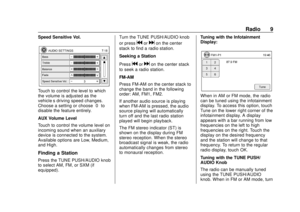
.Speed Limit Sensitivity
Touch to change the
sensitivity level for the
speed lim")
Chevrolet City Express Infotainment System (GMNA-Localizing-U.S./Canada-
11683801) - 2018 - crc - 7/12/17
Navigation 29
.Speed Limit Sensitivity
Touch to change the
sensitivity level for the
speed limit warning.
Choose a value between
zero and 30.
. Speed Warning for Curves
Touch to control the alert
that activates depending on
vehicle speed and a curve
in the road ahead. Choose
Off to disable the alert.
Choose Show Only to have
the alert display. Choose
Show & Beep to have an
audible beep in addition to
the alert displaying.
. Distance Units
Touch to switch between
US or Metric for the
distance units on the
map view. Lane Information
When the vehicle is approaching a
junction or interchange, the display
switches to a split view. Lane
information is graphically displayed
on the left side of the split display
and icons showing the proper lanes
for upcoming maneuvers are shown
in the upper right corner below the
clock.
The highlighted lanes are those
from which the next maneuver on
the route will be made. Lanes
displayed in gray are those that do
not follow the route at the upcoming
junction or interchange. The icons in
the upper right corner also indicate
direction and may change as the
junction or interchange approaches. Once the vehicle passes through
the junction or interchange, the
display returns to the previous view.
Lane information is not available for
all areas. It will only be displayed in
areas where the necessary map
data is available.
The number of lane icons in the
upper right corner may change as
the junction or interchange
approaches due to a difference in
the number of available lanes.
Page 31 of 74
 - 2018 - crc - 7/12/17
30 Navigation
Maps
This section includes basic
information about the map
database.
The data is")
Chevrolet City Express Infotainment System (GMNA-Localizing-U.S./Canada-
11683801) - 2018 - crc - 7/12/17
30 Navigation
Maps
This section includes basic
information about the map
database.
The data is stored in the internal
flash memory that is used in the
navigation system.
Detailed Areas
Road network attributes are
contained in the map database for
detailed areas. Attributes include
information such as street names,
street addresses, and turn
restrictions. A detailed area includes
all major highways, service roads,
and residential roads. The detailed
areas include points of interest
(POIs) such as restaurants, airports,
banks, hospitals, police stations,
gas stations, tourist attractions, and
historical monuments. The map
database may not include data for
newly constructed areas or map
database corrections. The
navigation system provides full
route guidance in the detailed map
areas.
Destination
Navigation Display
Several methods are available to
set your destination.
Basic Operation1. Press NAV on the center stack.
2. Select the appropriate destination setting method by
touching the display.
Available Setting Items
. Street Address:
Set a destination address.
Several methods are available to
set a destination. .
Points of Interest:
The system features a database
of places such as restaurants,
hotels, banks, and more to
assist in navigation. These
points of interest can be set as
destinations and the system can
then calculate a route.
. Cancel Route:
Touch to cancel route guidance.
If route guidance is not active,
Cancel Route will not work.
. Previous Destinations:
Searches for a destination from
the previous destinations in the
destination memory.
Up to 50 previous destinations
will be automatically stored.
If the number of previous
destinations exceeds 50, the
oldest one will be removed from
the list and the newest one will
be added.
To manually delete a previous
destination entry, select an entry
from the list and then touch
Delete.
Page 32 of 74
 - 2018 - crc - 7/12/17
Navigation 31
Touch Save to add a previous
destination to the address book.
Previous destinati")
Chevrolet City Express Infotainment System (GMNA-Localizing-U.S./Canada-
11683801) - 2018 - crc - 7/12/17
Navigation 31
Touch Save to add a previous
destination to the address book.
Previous destinations can also
be selected using voice
recognition, if equipped.
‐Press
g/Von the steering
wheel. The system provides
prompts and waits for voice
commands.
‐ Say “Navigation.”
‐ Say “Previous destinations.”
‐ Speak the number of an entry
on the displayed list to choose
that destination, or say “Next
Page” to view more entries (if
available).
If no route is set, route
guidance is calculated
automatically. If a route is set,
say “Replace Destination” to
use the chosen previous
destination as the new
destination. Say “Set as
Waypoint” to add the chosen
previous destination as a
waypoint on the current route. Say
“Show on Map” to show
the chosen previous
destination on the map.
It is not possible to retrieve
deleted previous destination
entries.
. Home:
Your home address can be
entered as a destination. Home
can also be set as a destination
using voice recognition.
‐Press
g/Von the steering
wheel. The system provides
prompts and waits for voice
commands.
‐ Say “Navigation.”
‐ Say “Home.”
If a home location is set, route
guidance to the home location
is calculated automatically.
. Address Book:
Touch to access stored
addresses. .
Intersection:
Touch to designate an
intersection of two roads as a
destination.
. City Center:
Touch to designate a city as a
destination.
. My Points of Interest:
My Points of Interest are
locations entered into the
system through the vehicle’s
USB port.
Alpha-Numeric Keyboard
Letters of the alphabet, symbols,
punctuation, and numbers, when
available, show on the navigation
display as alpha-numeric
keyboards. The alpha keyboard
displays when data needs to be
entered.