Page 185 of 261

Switching to navigation mode
X Press the NAVI button.
The main menu appears. Entering the destination
Entering characters :
Entry line
; Results list
= To delete characters
? To hide the keypad
A To cancel an entry
X Enter characters using the keypad.
Results matching the current entry appear in
results list ;.
X To hide the keypa
dand switc htothe
results list: select keypadsym bol ?.
X To cancel the entry: selectA.
X To complete the entry: select the entry from
the results list.
Entering adestinatio nbyaddress Address entry options
Yo uc an,for example:
R ente ratownorp ostcode, stree tand house
number
R ente ratownorp ostcode and street
R ente ratownorp ostcode and centre
R ente ratownorp ostcode, stree tand junction
i You can ente
rany of th etow ns,streets,
postcodes, etc. that are store dinthedigital
map. However, postcodes are no tavailable
for som ecountries .Countr yand town are suf-
ficien ttostart navigating .You can enter
either atow norap ostcode. The stree tand house number complete the destination
address.
Entering an addre ss
This example shows how to enter an address in the form of acountry, town, street and house
number or acrossing street.
X Press the NAVI button.
The main menu appears.
X Select New Route New Route.
X Select Address
Address.
X To enter the country: select the input line for
Country
Country in the input menu for addresses.
An input menu appears.
X Enter the desired country.
The results list appears below the input line.
X To hide the keypad: select the keypad sym-
bol.
X Select the desired countryf rom the results
list.
The countrya ppears in the address input
menu.
X To enter the town: select the input line for
Town or Postcode Town or Postcode in the input menu for
addresses.
An input menu appears.
X Select the desired town.
The results list appears below the input line.
X Proceed as described in "Entering acountry".
X To selectt
he centre of the town as ades-
tination: selectGo to Town Go to Town.
The location is shown on the map.
or
X To enter the street: select the input line for
Street
Street in the input menu for addresses.
An input menu appears.
X Enter the desired street.
The results list appears below the input line.
X Proceed as described in "Entering acountry".
X To complete the address entry without
further address details:
selectGo to
Go to
Street Street.
The location is shown on the map.
or X To enter the house number or crossing
street:
selectHouse House number
number or
orcrossing
crossing
street
street.
An input menu appears. 182
NavigationMultimedia system
Page 186 of 261

X
Enter the desired house numbe rorcrossing
street.
The results list appear sbelow the input line.
X To complete the address entry: select the
address in the results list.
The location is shown on the map.
X Select Select as Destination Select as Destination.
The route is being calculated.
X To start rout eguidance: selectStart
Start Nav‐
Nav‐
igation
igation.
Selecting adestinatio nfromp oints of
interest (POI) X
Pres sthe NAVI button.
The main menu appears.
X Select New Route
New Route.
X Select Places
Places.
Al ist with preset categories appears.
X Select the desired category.
Al ist of points of interest appears.
or X Select Search by Name or Category Search by Name or Category.
X Select Around Here
Around Here.
X Select the area in which the point of interest is
to be found.
If ad estination is selected, Along AlongRoute
Routeand
Around Destination
Around Destination can be selected.
X IfIn aTown
In aTown has been selected: enter the
town.
X Select the desired main category.
X Select the desired subcategory.
Al ist of points of interest appears.
X Select the desired POI.
The location is shown on the map.
X Select Select as Destination Select as Destination.
The route is being calculated.
X To start route guidance: selectStart
Start Nav‐
Nav‐
igation
igation.
Selecting adestination from the desti-
nation memory At least one location must be saved in "Saved
Loc ation".
X Press the NAVI button.
The main menu appears.
X Select New Route
New Route.
X Select Saved Location
Saved Location.
The list of saved locations appears. or
X Select ★.
The lis tofsaved locations appears.
X Select the desired location.
The location is shown on the map.
X Select Select as Destination Select as Destination.
The route is being calculated.
X To startr oute guidance: selectStart Start Nav‐
Nav‐
igation
igation.
Selecting adestination from the list of
last destinations X
Press the NAVI button.
The main menu appears.
X Select New Route
New Route.
X Select Last Destinations Last Destinations.
The list of your last destinations appears.
X Select the desired destination.
The location is shown on the map.
X Select Select as Destination Select as Destination.
The route is being calculated.
X To startr outeguidance: selectStart
Start Nav‐
Nav‐
igation
igation.
Selecting adestination from the saved
routes Requirement
:atleast on erout em ustbes aved
in "Saved Routes".
X Press th eNAVIbutton.
The main men uappears.
X Select New Route
New Route.
X Select Saved Routes
Saved Routes .
The list of saved routes appears.
X Selec tthe desired route.
The rout elist appears.
X To star troute calculation:select Calcu‐
Calcu‐
lat eR oute
lat eR oute.
X To star troute guidance: selectStart
Start Nav‐
Nav‐
igation
igation.
Entering adestination using coordi-
nates X
Pres sthe NAVI button.
The main menu appears.
X Select New Route
New Route.
X Select Coordinates
Coordinates.
X Enter the desired latitude. Navigati
on
183Multimedi asystem Z
Page 187 of 261

X
Select OK
OK.
X Enter the desire dlon gitude.
X Select Go!
Go!
The location is shown on the map.
X Select Select as Destination
Select as Destination.
The route is being calculated.
X To start route guidance: selectStart
Start Nav‐
Nav‐
igation
igation.
Selecting adestinatio nfrom all possible
destinations X
Press the NAV Ibutton.
The main menu appears.
X Select New Route
New Route.
X Select Search in All
Search in All.
Am enu appears. The currently selected
search area is displayed on the right.
X Enter the name, address or category of the
destination you are searching for.
X Select è.
Al ist of possible destinations appears.
The search results appear in the right-hand
column, filtered by category, e.g. Last des‐ Last des‐
tinations
tinations.
X Select the desired category.
Al ist of destinations in the selected category
appears.
X Select the desired destination.
The location is shown on the map.
X Select Select as Destination Select as Destination.
The route is being calculated.
X To start route guidance: selectStart
Start Nav‐
Nav‐
igation
igation.
Selecting adestination using the map X
Press the MAP button.
The map view appears.
X Move the map to the desired position.
X Select the desired point on the map.
The cursor appears.
X Select Select as Destination
Select as Destination.
The route is being calculated.
X To start route guidance: selectStart
Start Nav‐
Nav‐
igation
igation. Rout
es
Creatin ganewroute X
Press the NAV Ibutton.
The main menu appears.
X Select Multipoint Route Multipoint Route.
The route list appears.
X Select the Destination Destination.
X Enter the desired destination.
The location is shown on the map.
X Select Select as Destination Select as Destination.
The route list appears.
X To add intermediate destinations: select
add waypoint
add waypoint.
X Enter the desired destination.
The location is shown on the map.
X Select select as waypoint select as waypoint.
The route list appears.
X To startr outecalculation:select Calcu‐
Calcu‐
late Route
late Route.
X To startr outeguidance: selectStart
Start Nav‐
Nav‐
igation
igation.
Saving the route X
Create ther oute.
X To star troute calculation:select Calcu‐
Calcu‐
lat eR oute
lat eR oute.
The rout eoverview appears.
X Select 3.
X Select SaveR oute
Sav eR oute.
X Select Y.
The rout eissavedunde r"Saved Routes".
Saving th eactive route:
X Select S.
The main men uappears.
X Select Route Summary
Route Summary.
X Select 3.
X Select SaveR oute
Sav eR oute.
X Select Y.
The rout eissavedunde r"Saved Routes".
Renamin gsave droutes:
X Press th eNAVIbutton.
The main men uappears.
X Select New Route
New Route.
X Select Saved Routes
Saved Routes .
The list of save droutes appears.
X Select 3. 184
NavigationMultimedia system
Page 188 of 261

X
Select Edit Edit.
X Select the desire droute.
Am enu appears.
X Select Rename Rename.
X Enter the desire dname.
X Select Y.
Changing the save droute X
Press the NAV Ibutton.
The main menu appears.
X Select New Route
New Route.
X Select Saved Routes
Saved Routes.
The list of saved routes appears.
X Select the desired route.
The route list appears.
X To change the order of the destinations:
select the desired route.
Am
enu appears.
X Select Move Up Move Up orMove Down
Move Down.
The destination is moved one position up or
down the route list.
X To delete single destinations: select the
desired destination.
Am enu appears.
X Select Delete
Delete.
The destination is deleted from the route list.
X To add an intermediate destination: select
add waypoint add waypoint where you inten dtoadd the
intermediate destination.
X Enter the desired destination.
The location is shown on the map.
X Select select as waypoint select as waypoint.
The route list appears.
X To enter anew final destination: select
Final Destination
Final Destination.
X Enter the desired destination.
The location is shown on the map.
X Select Select as Destination
Select as Destination.
The route list appears.
X To startr outecalculation:select Calcu‐
Calcu‐
late Route
late Route.
X To startr outeguidance: selectStart
Start Nav‐
Nav‐
igation
igation. Changing the active route Adding an intermediate destination
X Select S.
The main menu appears.
X Select add waypoint
add waypoint.
X Enter the desired destination.
The location is shown on the map.
X Select select as waypoint
select as waypoint.
Avoidi ng special sections on th eroute
X Select S.
The main men uappears.
X Select Detour s&Alternatives
Detour s&Alternatives .
X Select Avoid Specia lSections
Avoid Specia lSections.
Al ist of special sections appears.
X Selec tthe desired special section.
The multimedia system calculates an alterna-
tiv er out eexcluding th eselected special sec-
tion.
X To select an alternative route: select
accept accept .
Avoiding specific roads on th eroute
X Select S.
The main men uappears.
X Select Detour s&Alternatives
Detour s&Alternatives .
X Select Avoid Specific Road
Avoid Specific Road.
Al ist of th eroad sont herout eappears.
X Selec tthe desired road.
The multimedia system calculates an alterna- tiv er out eexcluding th eselected road.
X To select an alternative route: select
accept
accept .
Avoiding th eroute ahead
X Select S.
The main men uappears.
X Select Detour s&Alternatives
Detour s&Alternatives .
X Select Avoid route ahead
Avoid route ahead.
The map appears. The rout eahead is high-
lighted.
X Use W orX to select th elengt hoft he
rout etobea voided.
The ne wrout eappears.
X To select an alternative route: select
Avoid
Avoid. Navigation
185Multimedia system Z
Page 189 of 261

Restoring the original route
X Select S.
The mai nmenu appears.
X Select Detours &Alternatives
Detours &Alternatives .
X Select Restore Original Route
Restore Original Route.
Showing alternativ eroutes Thi
sfunction is availabl ewhen aroute has been
calculated or during active route guidance.
X Route guidance activated: selectS.
The main menu appears.
X Select Detours &Alternatives
Detours &Alternatives.
X Select Alternative Routes
Alternative Routes.
Alternative routes are displayed.
or X Route calculated: selectAlternatives
Alternatives.
Alternative routes are displayed.
X To show alternative routes on the map:
select one of the routes.
X To show further alternatives: selectMore
More
Results
Results.
X To select the alternative route: select
Select Select.
X To startr outeguidance: selectStart
Start Nav‐
Nav‐
igation
igation.
Pausing and resuming active route
guidance X
To pause route guidan ce:press the NAVI
button.
The main menu appears.
X Select Ë.
The Guidance paused
Guidance paused message appears.
X To resume route guidance: selectCon‐ Con‐
tinue Guidance
tinue Guidance.
or X Select ;in the mai nmenu.
Deletin gthe next intermediate destina-
tio nora ctive route X
Select S.
The mai nmenu appears.
X Select Delete Waypoint
Delete Waypoint .
Aq uery appears. X
To delete the entire route: selectdelete delete
route route.
Route guidance is cancelled. The active route
is deleted.
X To delete the next intermediate destina-
tion: select Delete Waypoint
Delete Waypoint.
The next intermediate destination is deleted.
The multimedia system recalculates the
route.
Deleting the saved route Deletin
gasingle saved route
X Press th eNAVIbutton.
The main men uappears.
X Select New Route New Route.
X Select Saved Routes Saved Routes .
The list of saved route sappears.
X Select 4.
X Select Edit
Edit.
X Selec tthe desire droute.
Am enua ppears.
X Select Delete
Delete .
Deleting all saved routes
X Press th eNAVIbutton.
The main men uappears.
X Select New Route
New Route.
X Select Saved Routes
Saved Routes .
The list of saved route sappears.
X Select 4.
X Select Edit
Edit.
X Selec taroute.
Am enua ppears.
X Select Delete All
Delete All .
Defining anew starting point The curren
tvehicle position is the standard
starting point for route guidance. The starting
point may be changed.
This function can be used to plan aroute, for
example.
X Press the NAVI button.
The main menu appears.
X Select Multipoint Route Multipoint Route.
The route list appears.
X Select Current GPS Position
Current GPS Position.
X Select Set Starting Point
Set Starting Point.
Am essage appears. 186
NavigationMultimedia system
Page 190 of 261

X
Select OK OK.
X Enter the desire dstarting point.
The location is shown on the map.
X Select Select as Destination
Select as Destination.
The route list appears.
X If desired, enter the destination as well as
intermediate destinations.
X Select Calculat eRoute
Calculat eRoute.
The route appears on the map.
X To start route guidance: selectStart Start Nav‐
Nav‐
igation
igation.
X To resume standard route guidance: select
the starting point.
X Select Delete
Delete.
Am essage appears.
X Select OK
OK.
The current vehicl eposition is restored as the
starting point for route guidance.
Startin groute simulation Ar
oute can be simulated using thi sfun ction.
X Create the route.
X To start route calculation: selectCalcu‐
Calcu‐
lat eRoute
lat eRoute.
The route overview appears.
X Select 4.
X Select Simulation
Simulation.
The simulatio nbegin s.
X To ski
pbacktot he previous chang eof
direction: selectC.
X To ski
pforward to the next chang eof
direction: selectD.
X To interrupt the simulation: selectË.
X To increase the simulatio nspeed: select
1x.
The simulatio nspeed is increased 4-fold, 8-
fol dor1 6-fold.
X To en dthe simulation: selectX. Saving the destination
X Enter the desire ddestination.
The location is shown on the map.
X Select 4.
X Select Save Location Save Location.
X Select Y.
The destination is saved in Saved
Saved Location
Location. During route guidance
Navigation announceme nts Navigatio
nmessagess houldguideyou during
the journey withoutd istracting you from traffic
conditions or driving. Alwaysu se this function
as ag uidei nstead of the map display. The sym-
bols or the map display could distract you from traffic conditions and driving.
Repeating navigation announcements X
Press the MAP button.
The map view appears.
X Press the MAP button again.
The multimedia system repeat sthe previous
navigation message.
Display during routeg uidance :
Current vehicle position
; Current distanc etodestination
= Curren tdriving tim etodestination
? Estimate dtimeofa rrival at th edestination
Changing direction :
Nex tchange of direction and distance to
change of direction
; Change of direction after the next
= Next road or town Nav
igation
187Multimedi asystem Z
Page 191 of 261

The symbol indicatin
gthe change of direction
also indicates the type of change of direction,
e.g. aleft turn. If another change of direction will
be required immediately after you have changed direction ,the change of direction after the next
is indicated by asmaller symbol.
Lane recommendations :
Recommended lane
; Non-recommended lane
If the digi talm ap contain sthe relevan tdata, the
multimedia system can display lan erecommen-
dation sonm ulti-lane road sfor th enextc hange
of direction .Lan er ecommendation sare indica-
te datt hebotto moft hemap usin gsmall arrows.
The recommended lan eishighlighted. :
Recommended lane
; Non-recommended lane
If additional information is available, th earrows
are replace dbytraffic signs. The traffic signs
indicat epossibl edestination sand th enumber
of th eroad that leads to th erecommended lane.
The sign swhichlead to th erecommended lane
are highlighte dduring active rout eguidance.
Traffic event sonthemap Road section
saffecte dbytraffic event sare
shown on th emap in adifferen tcolour .The type
of traffic event is indicated by asymbol. :
Traffic even tsymbol
X Press the MAP button.
The map view appears.
X Select the traffic event symbol.
X Select Traffic Summary Traffic Summary.
X Select Traffic Events
Traffic Events.
Al ist of all traffic event sappears.
X Select atraffic event.
The traffic event details appear.
Displaying useful information. The following functions are available
R Where Am I
Where Am I:i ndicates the current vehicle
position
R Help Nearby
Help Nearby:i ndicates predefined POI cat-
egories, such as nearby workshops
R Country Information
Country Information :provides informa-
tion on the selected country, e.g. maximum
permissible speeds
R Trip Monitor Trip Monitor:p rovides statistic trip data,
e.g. the average speed
R Sunrise &Sunset
Sunrise &Sunset:i ndicates the time of
sunrise and sunset at the current vehicle posi- tion
R GPS Information
GPS Information :provides information on
GPS signal strength and the location of satel-
lites
X Press the NAVI button.
The main menu appears.
X Select Useful Information Useful Information .
X Select the desired information. 188
NavigationMultimedia system
Page 192 of 261

Adjusting navigation settings
Defining th eroute calculation settings Takin
gsettings into accoun tdurin groute
calculation
i Depending on local conditions, the multi-
media system ma ynot always be able to take
into account al lsettings. The calculate droute
ma yinclud eferry connections, for example,
eve nthough "Avoi dferries" is enabled.
Settin gthe vehicle profile
X Press the NAVI button.
The main menu appears.
X Select Settings
Settings.
X Select Route Preferences Route Preferences.
X Select Vehicle
Vehicle.
X Select the typ eofvehicle.
X To create anew profile: selectAdd Pro‐
Add Pro‐
file
file.
X Select the typ eofvehicle.
X Set the vehicl efactor.
Settin gthe route planning method
The following functions ar eavailable:
R Fast
Fast:t he multimedia system calculate sa
route with the shortes tpossibl ejourney time
R Easy
Easy:t he multimedia system calculate sthe
easiest possibl eroute, e.g .withasf ew turns
as possible
R Short
Short:t he multimedia system calculate sa
route covering the shortes tdistance
R Green
Green:t he multimedia system calculate sa
route covering the mos teconomical distance
X Press the NAVI button.
The main menu appears.
X Select Settings
Settings.
X Select Route Preferences
Route Preferences.
X Select Route Planning Method
Route Planning Method .
Am enu appears.
X Select the desired function.
The Ytick mark indicates the activated
function.
Settin gthe navigatio nmode
If the Off-road
Off-road functionisa ctivated ,astraight
line to the driving destination is calculate dwhen
driving off-road. X
Pres sthe NAVI button.
The main menu appears.
X Select Settings
Settings.
X Select Route Preferences Route Preferences.
X Select Navigation Mode
Navigation Mode.
Am enu appears.
X Select the desired function.
The Ytick mark indicates the activated
function.
Setting road types
The following functions are available:
R Motorways Motorways:w hen this function is activated,
motorways are taken into account during
route calculation
R Road Road With
WithPeriod
Period Charge
Charge:w hen this func-
tion is activated, roads for which there is a
time-dependent usage fee are taken into
account during route calculation
R Road With Per-use Toll
Road With Per-use Toll:w hen this func-
tion is activated, roads for which there is a
distance-dependen tusage fee are taken into
account during route calculation
R Ferries Ferries:w hen this function is activated, fer-
ries are taken into account during route cal-
culation
R Car Shuttle Trains Car Shuttle Trains:w hen this function is
activated, motorails are taken into account
during route calculation
R Unpaved Roads Unpaved Roads:w hen this function is acti-
vated, unpaved roads are taken into account
during route calculation
X Press the NAVI button.
The main menu appears.
X Select Settings
Settings.
X Select Route Preferences Route Preferences.
X Select the desired function.
The function is activated or deactivated.
Defining the sound output settings Adjusting the volume for sound output
Using this function, the volume of signal tones
and voice output can be adjusted in relation to
radi oand media volume.
The followin gfunction sare available:
R Master Master :adjust sthe volume of all soun dout-
put
R Voice
Voice:a djuststhe volume of voice outputs Navigation
189Multimedia system Z
 1
1 2
2 3
3 4
4 5
5 6
6 7
7 8
8 9
9 10
10 11
11 12
12 13
13 14
14 15
15 16
16 17
17 18
18 19
19 20
20 21
21 22
22 23
23 24
24 25
25 26
26 27
27 28
28 29
29 30
30 31
31 32
32 33
33 34
34 35
35 36
36 37
37 38
38 39
39 40
40 41
41 42
42 43
43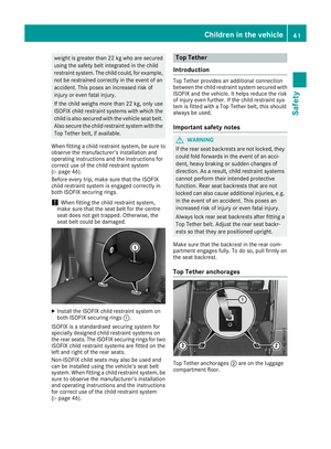 44
44 45
45 46
46 47
47 48
48 49
49 50
50 51
51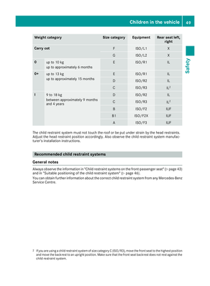 52
52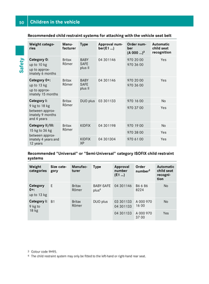 53
53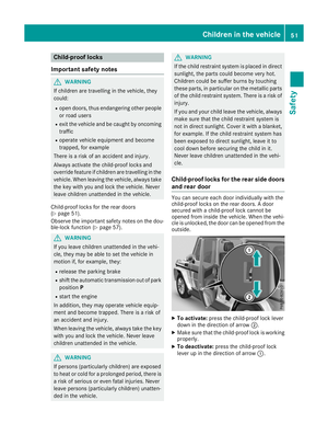 54
54 55
55 56
56 57
57 58
58 59
59 60
60 61
61 62
62 63
63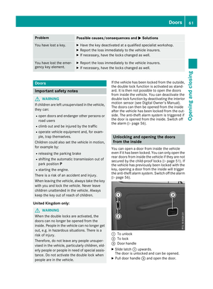 64
64 65
65 66
66 67
67 68
68 69
69 70
70 71
71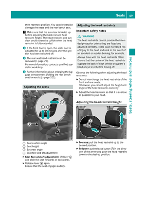 72
72 73
73 74
74 75
75 76
76 77
77 78
78 79
79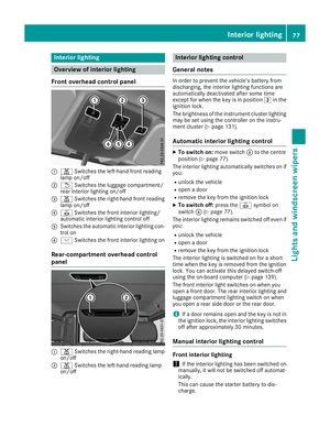 80
80 81
81 82
82 83
83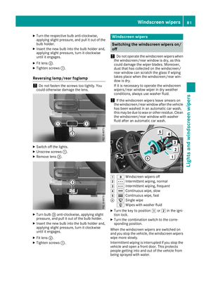 84
84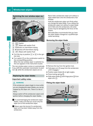 85
85 86
86 87
87 88
88 89
89 90
90 91
91 92
92 93
93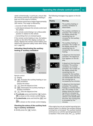 94
94 95
95 96
96 97
97 98
98 99
99 100
100 101
101 102
102 103
103 104
104 105
105 106
106 107
107 108
108 109
109 110
110 111
111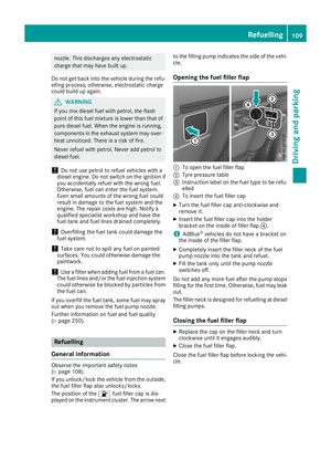 112
112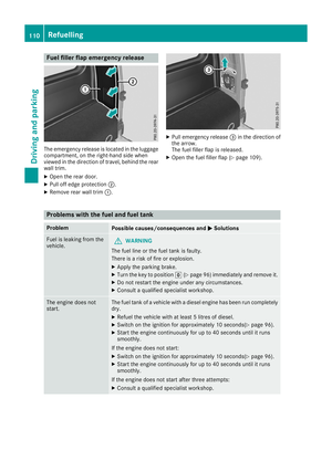 113
113 114
114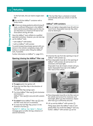 115
115 116
116 117
117 118
118 119
119 120
120 121
121 122
122 123
123 124
124 125
125 126
126 127
127 128
128 129
129 130
130 131
131 132
132 133
133 134
134 135
135 136
136 137
137 138
138 139
139 140
140 141
141 142
142 143
143 144
144 145
145 146
146 147
147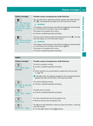 148
148 149
149 150
150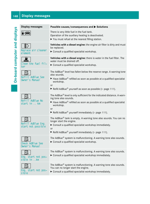 151
151 152
152 153
153 154
154 155
155 156
156 157
157 158
158 159
159 160
160 161
161 162
162 163
163 164
164 165
165 166
166 167
167 168
168 169
169 170
170 171
171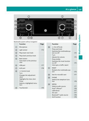 172
172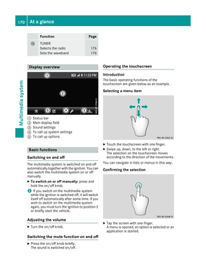 173
173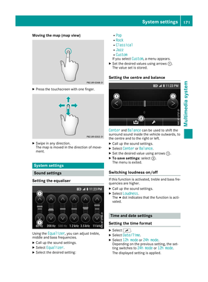 174
174 175
175 176
176 177
177 178
178 179
179 180
180 181
181 182
182 183
183 184
184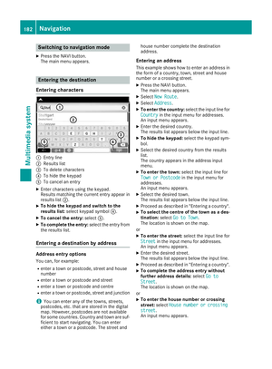 185
185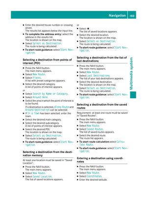 186
186 187
187 188
188 189
189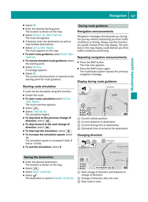 190
190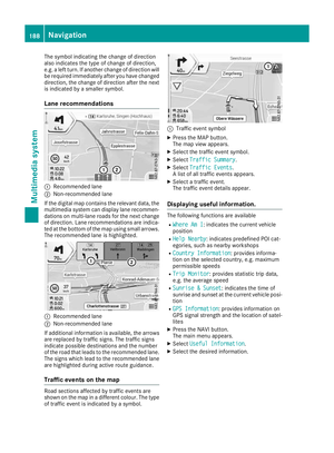 191
191 192
192 193
193 194
194 195
195 196
196 197
197 198
198 199
199 200
200 201
201 202
202 203
203 204
204 205
205 206
206 207
207 208
208 209
209 210
210 211
211 212
212 213
213 214
214 215
215 216
216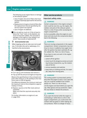 217
217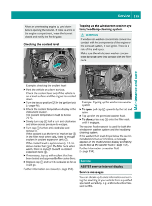 218
218 219
219 220
220 221
221 222
222 223
223 224
224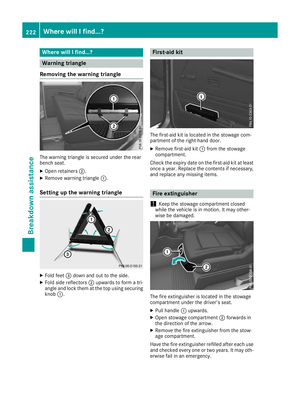 225
225 226
226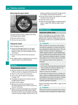 227
227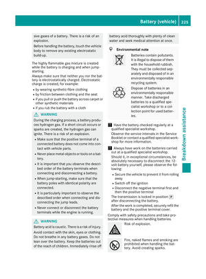 228
228 229
229 230
230 231
231 232
232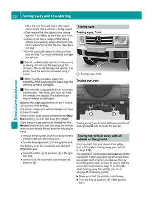 233
233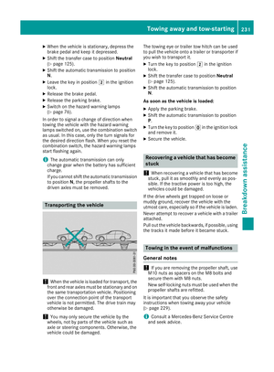 234
234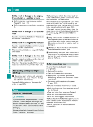 235
235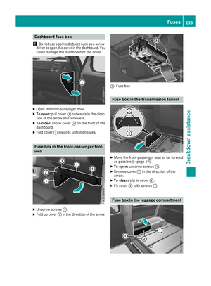 236
236 237
237 238
238 239
239 240
240 241
241 242
242 243
243 244
244 245
245 246
246 247
247 248
248 249
249 250
250 251
251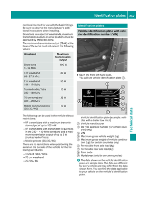 252
252 253
253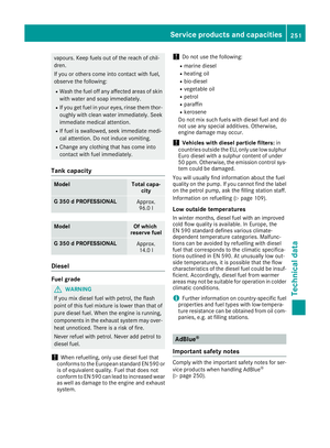 254
254 255
255 256
256 257
257 258
258 259
259 260
260