2017 AUDI Q7 display
[x] Cancel search: displayPage 212 of 402
Navig ation
Entering a destination using geo
coordinates
Applies to: veh icles with navigation system
~ Press the I NAV/MAPI button repeated ly until
the
Ent er de stin ation menu is displayed
¢page 205, fig.189 .
~ Select: left control button > G eo coordi nates.
- Se lect L a titude /Lo ng itude.
- Press the control knob to set the individua l val -
u es .
- T urn the cont rol knob to the left/r ight to
change the se lected value.
- Se lect and confirm
Start rout e guidance .
Adding a stopover
Applies to : vehicles with navigation system
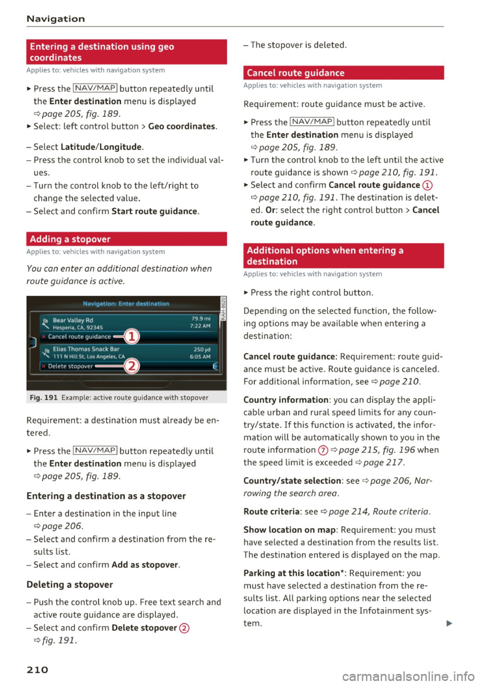
You can enter an additional destination when
route guidance is active.
N.-tviy,ltion . Fnh.•r d1_• in,,tion
l~ Bear Valley Rd
'"'-. HC'sp -cna , CA, 92345
J Cance l route guidance ==O
JI, Elias Thomas Snack Bar
' 111 N H1ll St , Lo o; Ange l~ !.. CA
Delete stopover ====~lfJ
79.9mi
7 ,12 AM
250 yd
6 005 AM
Fig . 191 Exa mple: active route g uidance w ith stopover
C ·
Requ irement: a destination must a lready be en
tered.
~ Press the I NAV/MAPI button repeatedly until
the
Ent er de stination menu is displayed
¢ page 205, fig . 189.
Entering a de stin ation as a stopo ver
- Enter a destination in the input line
¢ page 206.
- Select and confirm a destination from the re-
su lts list .
- Se lect and confirm
Add as stopo ver .
De leting a stopover
I
F
- Push the cont rol knob up . Free text search and
active route guidan ce are displayed.
- Se lect and confirm
De lete s topov er@
¢ fig. 191.
210
-The stopover is deleted.
Cancel route guidance
Applies to: vehicles with navigat ion system
Requirement: route guidance must be active.
~ Press the I NAV/MAPI b utton repeatedly unti l
the
Enter de stination menu is displayed
r=;, page 205, fig . 189 .
~ Turn the control knob to the left unti l the active
route guidance is shown
r:::> page 210, fig. 191.
~ Select and confirm Can cel route guidance @
r=;,page 210, fig. 191 . The destination is de let
ed .
Or : select the right control butto n > Cancel
route guidance .
Additional options when entering a
destination
Applies to: vehicles with navigation system
~ Press the right con trol but ton.
Depend ing on the selected fu nction, the follow
i ng opt ions may be avai lab le when entering a
dest ina tion:
Cancel route guidance: Requ irement: route guid
an ce must be ac tive. Route guida nce is canceled.
Fo r addi tional information, see
r=;, page 210.
Countr y information : you can display t he appli
cable urban and ru ral speed limits for any coun
t ry/sta te . If this f unction is activated, the infor
ma tion will be automat ically shown to yo u in the
route in format ion
0 ¢ page 215, fig. 196 when
the speed limit is exceeded
r=;, page 217 .
Country/state sele ction : see¢ page 206, Nar
rowing the search area.
Route criteria: see r=;, page 214, Route criteria .
Show location on map : Requirement: you must
have selected a destination from the results list.
The destination entered is displayed on the map .
Parking at this locat ion *: Requirement: you
must have selected a dest inat ion from the re
su lts list. All park ing options near the selected
location are displayed in the Infotainment sys
tem.
Page 213 of 402
u (0 ...... N r--. N ...... 0
0
:E
l ete individual entries or all entries (for example,
favorites or last destinat ions).
Audi connect at thi s location *: Requirement: you
must have selected a destination from the re
sults list. Allows you to search for items in the v i
cinity of the selected location, such as
Travel in
formation.
Online traffic data* :
the on line traffic informa
tion ¢
page 221 can be switched on or off .
Add destination to contact : Requirement: a cell
phone must be connected to the MMI
¢page 176. See qpage 213.
Store as favorite : see q page 213.
Voice guidance : see c> page 214 .
Navigation settings: see¢ page 213.
(Di Tips
Information on online traffic data* can also
be found online at
www.audiusa.com.
Personal route
assistance
Ap plies to: ve hicles with navigation system and persona l
rou te ass istance
Your MMI can learn your frequently driven routes
and, depending on the current vehicle position,
suggest route guidance (for example, your daily commute to work and back) .
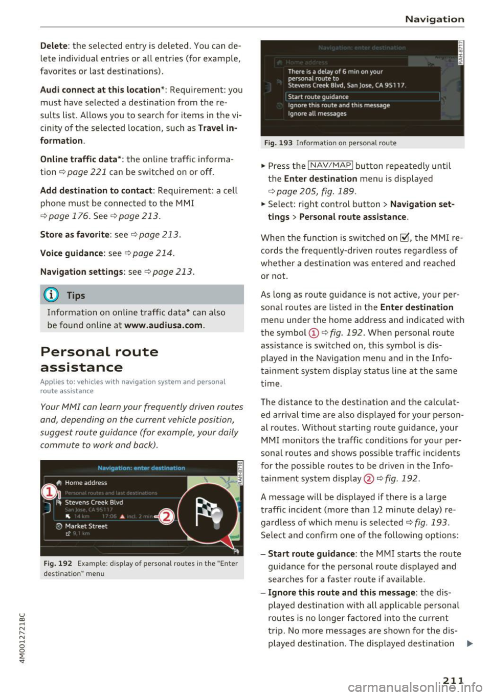
Fig. 192 Example: display o f personal routes in the "Enter
desti natio n" men u
Navigation
Fig. 193 In format ion o n perso nal route
"' Press the !NAV/MAPI button repeatedly until
the
Enter destination menu is displayed
¢page 205, fig.189 .
.,. Select: right control button > Navigation set-
tings
> Personal route assistance.
When the function is switched on~, the MMI re
cords the frequently-driven routes regardless of
whether a destination was entered and reached
or not.
As long as route guidance is not active, your per
sonal routes are listed in the
Enter destination
menu under the home address and indicated with
the symbol
CD c> fig. 192. When personal route
ass istance is switched on, this symbol is dis
played in the Navigation menu and in the Info
ta inment system display status line at the same
t ime .
The distance to the dest inat ion and the calculat
ed arrival time are also displayed for your person
al routes. Without starting route guidance, your
MMI monitors the traffic conditions for your per
sonal routes and shows possible traffic incidents
for the possible routes to be driven in the Info
tainment system display@¢
fig. 192.
A message will be displayed if there is a large
traffic incident (more than 12 minute delay) re
gardless of which men u is selected
q fig. 193.
Select and confirm one of the following options:
- Start route guidance : the MMI starts the route
guidan ce fo r the personal route displayed and
searches for a faster ro ute if available.
-Ignore this route and this message : the dis
p la yed destination with all applicable personal
routes is no longer factored into the current
trip . No more messages are shown for the d is
played destination. The disp layed destination ..,.
211
Page 214 of 402
Navigation
with all applicable personal routes will be fac
tored into the trip aga in only after stopping the
vehicle and switching the ignition on again .
-Ignore all messages: all personal routes are no
longer factored into the current trip. No more
messages a re disp layed. Messages for personal
route s when there is increased traffic will ap
pear again after the vehicle is stopped and the
ignition is sw itched on again .
As soon as you switch off personal route assis
tance, the symbol in the status line turns
off and
your trips are no longer recorded. Trips that were
already stored remain stored .
Deleting personal routes:
-Select the desired personal route in the Enter
destination
menu q fig. 192.
-Select : right control button > Delete destina
tion.
Deleting all personal routes :
-Select : I MENU I button >Settings > left control
button >
MMI settings > Factory settings .
-Select : Navigation and on line memory > Re·
store factory settings
q page 250.
(D Tips
-Personal routes are learned based on the ve
hicle position. The route is prioritized ac
cording to how frequently you drive to a
destination .
- A maximum of three personal routes are
displayed in the
Enter destination menu.
Based on the current vehicle position, the
traffic situation for the route that is most
likely to be driven out of the three routes
will always be monitored.
- Please note that personal routes that have
already been stored will remain stored after
the ignition is switched off and they must
be deleted manually.
212
Alternative routes
Applies to: vehicles with navigation system
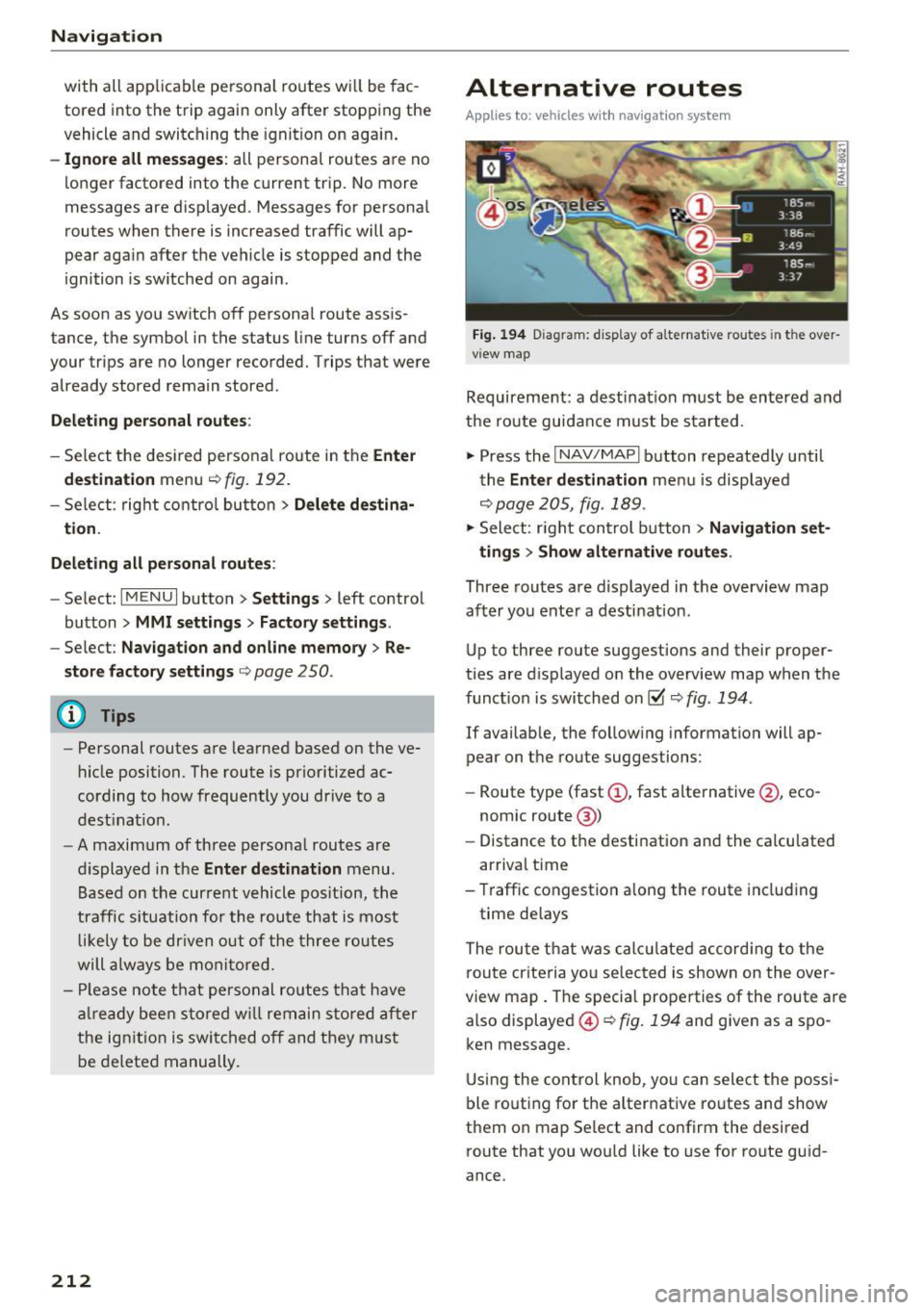
Fig. 194 D iag ram : disp lay of a lternat ive ro ute s in the over
view map
Requirement: a destination must be entered and
the route guidance must be started .
.,. Press the
I NAV/MAPI button repeatedly until
the
Enter destination menu is displayed
qpage 205, fig . 189 .
.,. Sele ct: right control b utton> Navigation set·
ting s
> Show alternative routes.
Three routes are displayed in the overview map
after you enter a destination .
Up to th ree route suggestions and their proper
ties are displayed on the overview map when the
funct io n is switched on~
q fig. 194 .
If availab le, the follow ing information will ap
pear on the route suggestions :
- Route type (fast
(D , fast alternative @, eco
nomic route@)
- Distance to the desti nation and the calcu lated
arr ival time
- Traffic congestion along the route including
time delays
The route that was calc ulated according to the
route criteria you selected is shown on the over
view map. The specia l properties of the route are
also displayed @
Q fig. 194 and given as a spo
ken message .
Using the control knob, you can select the possi
ble routing for the alternative routes and show
them on map Se lect and confirm the desired
route that you would like to use for route guid
ance.
Page 215 of 402
u co ...... N r-... N ...... 0
0
:E: '
Home address
Applies to: vehicles with navigation system
• Press t he I NAV/MAP I button repeated ly un til
t h e
Enter destination me nu i s di splayed
<=:>page 205, fig. 1 89.
Storing a home address
- Se lect and confirm Home address @
c::> page 205, fig . 189. Afte r opening the home
address for the firs t time, yo u will be asked to
cr eat e a home address.
- Se lect and co nfirm
Create now .
-Enter a desti nati on or select a des tina tion from
t h e lis t.
Or:
-Se lect and co nfirm a destination > right control
bu tton
> Store as home addre ss .
Editing the home address
- Se lect t he Home address @<=:> page 205 ,
fig. 189.
- Se lect the right control button > Edit home ad
dress .
-Se lect and co nfirm a new dest inat ion as t he
home address.
The se le ct ed des tin ation is sto re d as t he new
h ome address .
Favorites
Applies to: veh icles with navigation system
• Press t he I N AV/MAPI button repeated ly until
the
Enter destination menu is displayed
c::> page 205, fig. 189.
- Storing a destination as a favorite : search for
the des ired destination using the i nput f ie ld .
Or : select a destinat ion from the list. Select:
rig ht cont rol button
> Store as favorite .
- Renaming a favorite :
select: left contro l button
> Favorites > a favorite from the list> right
contro l button
> Rename favorite .
- Move favorite :
select a favorite from the list>
rig ht cont rol button> Move favorite . Select
and co nfirm the locat ion of t he s elected favor
i te .
Navigation
- Deleting a favorite :
select a favorite from the
list>
ri gh t cont rol b utton > Delete favorite >
Delete this favorite o r Delete all favorites.
Directory contacts
Applies to : vehicles with navigat ion system
Two addresses (private/business) can be as
signed as destinations for each contact in the di
rectory.
• Press the INAV/MAPI b utton repeatedly u nti l
the
Enter destination men u is disp laye d
c::> page 205 , fig . 18 9.
Storing a destination as a contact in the
directory
R equirement: a ce ll phone must be connected to
t h e MMI
<=:>page 176.
- Select: a destin ation > righ t con tro l b utt on >
Add destination to contact.
- En ter the fir st le tters of t he desir ed c ont act in
t he free text sear ch inpu t fie ld
c::> page 205,
fig. 189
an d th en select a contact from the list .
= Sele ct an d co nfirm Add business destination or
Add private destination.
Navigation settings
Appl ies to : vehicles with navigation system
• Press the INAV/MAPI b utton repeatedly unti l
the
Enter destination men u is disp laye d
<=:>page 205, fig.189.
• Select: r ight control b utton > Navigation set -
tings .
Depen ding on the selecte d function, the follow
ing setti ngs can be selected :
Show alternative routes
Up to three s ugges ted rou tes are shown on the
map w hen t his fu nction is switche d on ~
c::> page 2 12 .
Low fuel warning
A message is displ ayed if the fue l g auge goe s be
lo w the rese rve mar king w hen th is fu nctio n is
swi tched on~- Confirmin g this mess age disp lays..,.
213
Page 216 of 402
Navig ation
a list o f gas stations in the area. When a gas sta
tion is selected, route guidance from the current
veh icle position is calc ulated.
Trail er mode *
Trailer mode is sw itched off at the factory.
When the function is switched on~' the maxi
m um permitted speed for vehicles with trailers is
incorpo ra ted into the rou te g uidance and the ca l
culated arrival time is adjusted according ly. Trail
e r mode is disp layed using symbols-"' in the side
menu on the map .
Personal route assistance *
Personal route assistance is sw itched off at the
factory.
Your trips are recorded and destinations are sug
gested by the MMI when this f unct ion is switched
on~
¢ page 211 .
The personal route ass istance is indicated by the
~ symbol in the status line of the Infotainment
system display.
Notification when n ea rby *
The notification when nearby is switched off at
the factory .
The MMI notifies you when you are approaching
selected po ints of int erest whe n this function is
sw itched on~- You can a lso have a
Notification
tone .
Presentation mode
The Presentation mode helps yo u to effect ively
p lan a trip and follow the p lanned route without
moving the ve hicle . You can
Select starting point
when, for example , you would like to ca lculate a
route star ting from a locat ion other than the ve
h icle pos it io n. Start
Presentation mod e to simu
late route gu idance .
1> High occu pan cy vehi cle
214
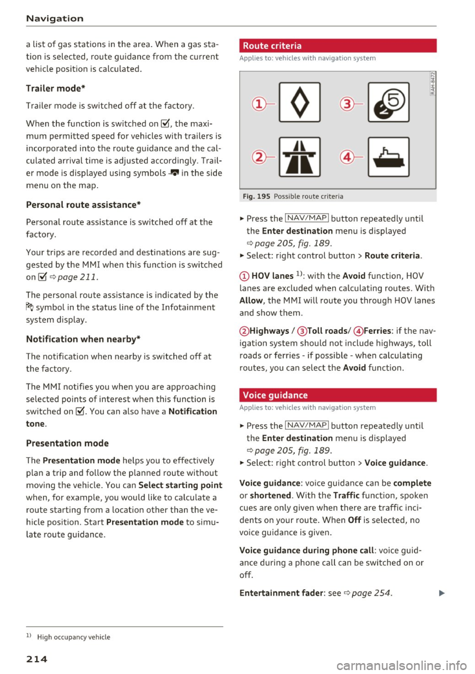
' Route criteria
Applies to: vehicles with navigation system
J(
Fig . 195 Poss ible ro ute c riter ia
.. Press the I NAV /MAP I button repeatedly until
the
Enter des tinat ion menu is displayed
¢page 205, fig. 189 .
.. Select: r ight control button> Rout e criteria .
(D HOV lanes 1>: with the Avoid function, HOV
l anes are excluded when ca lculating routes. With
Allow , the MMI will route you through HOV lanes
and show them .
@Highways /@ Toll roads /@ Ferries : if the nav
i gation system should not include highways, toll
roads or ferries -if poss ible -when calculat ing
routes, you can select the
Avoid f u nction.
Voice guidance
Applies to: vehicles with navigation system
.. Press the I NAV /MAPI button repeatedly unti l
the
En ter de stination me nu is displayed
¢page 205, fig. 189 .
.. Select: r ight con trol b utton> Voice guidance.
Voic e guidan ce :
vo ice guidance can be compl ete
o r shortened . With the Traffic func tion , spoken
cues are on ly given when there are traffic inc i
dents on your route. When
Off is se lected, no
voice guidance is given .
Voice guidan ce during phone call : voice guid
ance d uring a phone call can be swi tched on or
off.
Entertainment fader : see c::> page 254.
Page 217 of 402

u (0 ...... N r--. N ...... 0
0
:E
ume d uring voice guidance using the On/Off knob
c::> page 156 Yo u can also f ind additional in fo rma
tion under
c::> page 254.
Map
Operating the map
A ppl ies to: ve hicles with naviga tion system
F ig. 19 6 Exam ple: 30 map with th e cross hairs sw itched off
H4M
~
S FIQUt ra• St
F ig . 197 Exa mpl e: sta n dard m ap with t he cros sha ir s
sw itc hed o n
.. Press the I NAV/MAPI button repeated ly until
the map is d isplayed
<=> fig. 196.
Zoom ing in /out on the map
- T urn the cont rol k nob to the le ft or to the r ight.
Alte rn atively , you can also zoom in/out on the
map using the MM I touch contro l pad*
<=> page 161, if the c ross hairs are switched on .
Or: turn the left thumbwheel on the mu ltifunc
t ion steer ing whee l*<=>
page 13.
Turning the crosshairs on/off
- Switching th e crosshairs on :
press t he control
k no b in t he ma p view
c::> fig. 19 6.
- Switching the crosshairs off : press the I BACKI
button.
1l Only app lies to ve hicles w it h ou t camer a-based speed limit
disp lay .
Navigation
When the crosshairs are switched off
c::> fig. 196:
(D D irection . Fo r additional informa tion, see
c::>page 21 7.
@ The distance to the destinat ion includes the
calculated arrival time .
@ When the trailer mode func tion is sw itched
on~, the cor respond ing sy mbol is displayed
n ext to the arrival time.
@ Sca le: t urn the control knob to the left o r
right to decrease or increase the sca le . When
the
Automatic zoom function is sw itched on
~, an "A" for "A utomat ic" is d isplayed in the
magn ifying g lass .
® Altitude
@ Vehicle position
0 Route info rmation: var ious informa tion will
be displayed dur ing rou te g uidance ( fo r ex
amp le, the upcoming maneuver includin g
ca lculated distance and street names o r haz
ard info rmation*) . The display a lso provi des
traff ic information or po ints of interest on
the current route .
@ Road currently being d rive n on
When the crosshairs are switched on <=> fig. 197:
® The crosshairs: move the c rosshairs in the de-
s ired direct ion and set a point on the map us
i ng the MMI touc h control pad* or the con
trol knob . When the crosshairs are tur ned
off, the road be ing curren tly driven on is
shown .
@ Speed limit display1>: dis play of the max i
mum pe rm itted speed on t he expressways
and highways.
@ Ente rtain men t slidi ng menu*: only available
when media is active. More i nfo rmat ion can
b e fo und under
c::> page 162.
@ Additional information on the c ross hairs po
s it ion: if you move the crosshairs to a loca
t ion on the map, available information fo r
the current crosshairs position is displayed. Press the control knob to open desti nat ion
de tails or to start rou te g uidance.
215
Page 218 of 402

Navig ation
@ Map contents (points of interest, favorites).
When there are multip le points of interest in
the immediate vicinity, the symbo ls are
shown stacked on the map.
@ Better route re: if a better route is availab le
for the curren t route gu idance , it wi ll be indi
cated on the map includ ing the time that
wou ld be saved . More information can be
found under
c> page 221.
Map functions
Applies to: veh icles with navigation system
~ Press the I NAV/MAPI button repeated ly until
the map is d isp layed
c> page 215, fig. 196.
~ Press the left control button.
The fo llowing map functions can be selected:
Sw itch to destination input
The free text search in the Na vig ation menu is
d isp layed
c> page 205, fig. 189.
Traffic mes sages
Curre nt traffic information is displayed in the In
fotainment system disp lay . You can also find ad
d itiona l information under
c> page 220 .
Route list
The route list can only be displayed when route
guidance is active and contains information re
garding the route, the names of the streets and
the length of the route sections. Whe n trave ling
on hig hways, possib le pa rk ing lots and rest a reas
a re shown, wh ich yo u can select as a stopover.
POis along the route
Requirement: route guidance must be active .
Searching for points of interest along your cur rent route For addit iona l information, see
c>page208 .
Additional options on the map
Applies to: veh icles with navigation system
~ Press the I N AV/MAPI button repeatedly until
the map is d isp layed
r:::> page 215, fig . 196.
~ Press the right contro l button.
216
Depend ing on the function selected, the follow
ing options can also be selected under the
Map
menu:
Cancel route guidance: see c> page 210 .
Map setting s: see c> page 216 .
Route cr iteria : see c> page 214.
Voice guidance : see c> page 214.
Navigation settings : see r:::> page 213.
Show alternati ve route s: see c> page 212.
Parking along the route *: parking options near
the ve hicle are d isplayed .
Save current position : you can save your current
vehicle position as a favorite
c> page 213 or save
i t as a contact in the directory
c> page 213.
Audi connect at thi s location* : allows you to
search for
Travel info rmation at the entered lo
cation (events, weather at the destinat ion, etc.).
Online traffic data *: you can switch the online
traffic da ta and, depending on the equipment,
the ha zard information* on or off(~).
Countr y information : see c> page 210.
Avoid route *: when route guidance is active, the
ca lculated route will avoid the area you have
spec ified (maximum: 12 mi (20 km)), if possib le.
The nav igat ion sys tem calcu lates an alte rna tive
r oute . The route to be avo ided that yo u have en
te red applies only to the cur rent route and must
be set again, if needed. The areas you have se
l ected to avoid w ill appear with red and white
shading on the map .
Move route*: move your finger over the MM I
touch contro l pad* or use the contro l knob to ad
j ust the route on the overview map .
Map settings
Applies to: vehicles with navigat ion system
~ Press the I NAV/MAP I button repeatedly until
the map is displayed .
~ Select: right cont rol button> Map settings .
Depending on the selected function, the follow-
i ng settings can be selected: ...,
Page 219 of 402

u (0 ...... N r--. N ...... 0
0
:E
Day /Night :
the map is displayed with a light/
dark background.
Automatic : the map display adapts to the light
i ng conditions (fo r example, changing from
Day
to Night when driving thro ugh a tunne l).
Map display
Standard :
see c:>page 215, fig. 197 .
Online map view: see c:> page 217, fig. 198.
Map orientation
Destination :
the map indicates the dest ination
and is oriented to the north.
2D heading up map /2D north up map : the cur
rent vehicle position is dis played. The map is o ri·
ented in the direction of travel or to the north.
3D map *: the current vehicle pos ition is shown
on a th ree-dimensional map and is a ligned to the
d irection of travel. At a scale of 62 mi (100 km)
and larger, the map orientation is to the north.
Overview : the entire route from the vehicle posi·
tion to the destination or the next stopover is dis·
played on the map. The map scale depends on
the length of the route and adapts a utomatica lly.
The map is oriented to the north.
Route information
The display of route information, such as the cur·
rent street being driven on or po ints of in terest
along the current route
c;,page 215, fig. 196, can
be switched on/off or can be m inim ized on the
display of upcoming maneuvers .
Automatic zoom
On :
the map scale is adapted automat ically de·
pending on the type of road being traveled (ex·
pressway, highway, other roads) so that you al
ways have an optimal overview of the road ahead.
The sca le is also automatica lly adapted when
there are upcoming maneuvers to provide a bet·
ter detai led view.
Intersection : when route guidance is active, the
map temporarily zooms in to a detailed scale
Navigation
when there are upcoming maneuvers so that you
can see the street or turn better.
Off : the map scale you have chosen is main·
tained .
MMI map contents
Map contents, such as weather, points of inter·
est, traffic information or favorites, can be dis·
played or hidden.
The weather forecast is displayed on a 3 m i (5
km) scale on the map.
Instrument cluster map contents
You can also set which map content disp lays in
the instrument cluster
c:> page 19.
Online map display
Applies to: vehicles with a navigation system and Audi con·
nect (Infotainment)
With the on line map view, you can display the
map with satellite images.
Fig. 198 Example: on line map v iew
Fig . 199 Example: map view with onli ne St reet V iew
Requirement: the requirements for Aud i connect
(Infotainment) must be met
c:>page 189 .
.,. Press the !NAV/MAPI button repeatedly until
the map is displayed.
.,. Select: r ight control button
> Map settings >
Map display > Google Earth .
217