2019 MERCEDES-BENZ S CLASS light
[x] Cancel search: lightPage 307 of 578
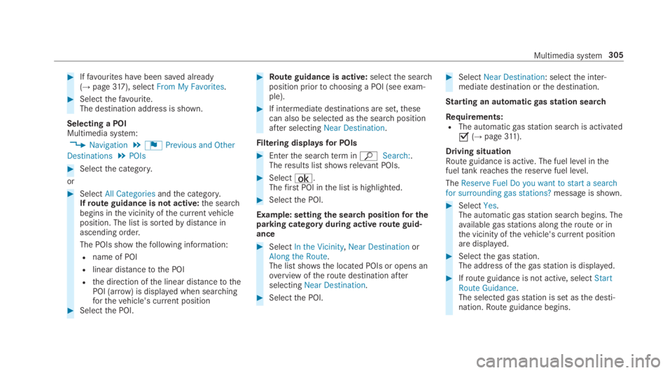
#Iffavourites havebeen saved already(→page317), selectFrom My Favorites.
#Selectthefavourite.The destination address is shown.
Selecting a POIMultimedia system:
,Navigation.¬Previous and Other
Destinations.POIs
#Selectthe category.
or
#SelectAll Categoriesandthe category.Ifroute guidance is not active:the searchbegins inthe vicinity ofthe currentvehicleposition. The list is sortedbydistance inascending order.
The POIs showthefollowing information:
Rname of POI
Rlinear distancetothe POI
Rthe direction ofthe linear distancetothePOI (arrow) is displayed when searchingforthevehicle's current position#Selectthe POI.
#Route guidance is active:selectthe searchposition priortochoosing a POI (seeexam‐ple).
#If intermediate destinations are set,thesecan also be selected asthe searchpositionafter selectingNear Destination.
Filtering displaysfor POIs
#Enterthe searchterminªSearch:.Theresults list showsrelevant POIs.
#Select¡.Thefirst POI inthe list is highlighted.
#Selectthe POI.
Example: settingthe searchpositionfor theparking category during activeroute guid‐ance
#SelectIn the Vicinity,Near DestinationorAlong the Route.The list shows the located POIs or opens anoverview oftheroute destination afterselectingNear Destination.
#Selectthe POI.
#SelectNear Destination: selectthe inter‐mediate destination orthe destination.
Starting an automaticgasstation search
Requirements:RThe automaticgasstation searchis activated�s(→page311).
Driving situationRoute guidance is active. The fuel level inthefueltankreachesthereservefuel level.
TheReserve Fuel Do you want to start a searchfor surrounding gas stations?message is shown.
#SelectYes.The automaticgasstation searchbegins. Theavailablegasstations alongtheroute or inthe vicinity ofthevehicle's current positionare displayed.
#Selectthegasstation.The address ofthegasstation is displayed.
#Ifroute guidance is not active, selectStartRoute Guidance.The selectedgasstation is set asthe desti‐nation.Route guidance begins.
Multimedia system305
Page 308 of 578
or
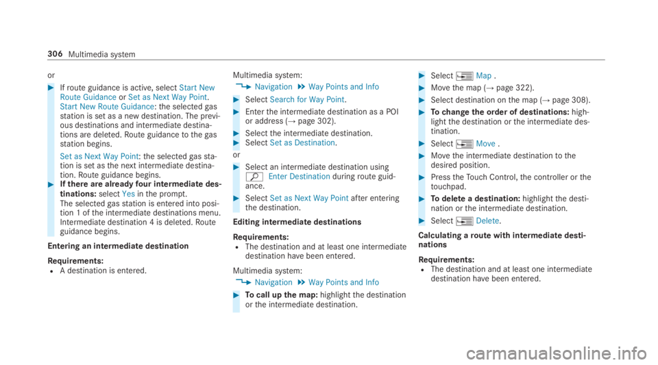
#Ifroute guidance is active, selectStart NewRoute GuidanceorSet as Next Way Point.Start New Route Guidance:the selectedgasstation is set as a new destination. The previ‐ous destinations and intermediate destina‐tions are deleted.Route guidancetothegasstation begins.
Set as Next Way Point:the selectedgassta‐tion is set asthe next intermediate destina‐tion.Route guidance begins.#Ifthere are alreadyfour intermediate des‐tinations:selectYesinthe prompt.The selectedgasstation is entered into posi‐tion 1 ofthe intermediate destinations menu.Intermediate destination 4 is deleted.Routeguidance begins.
Entering an intermediate destination
Requirements:RA destination is entered.
Multimedia system:
,Navigation.Way Points and Info
#SelectSearch for Way Point.
#Enterthe intermediate destination as a POIor address (→page 302).
#Selectthe intermediate destination.#SelectSet as Destination.
or
#Select an intermediate destination usingªEnter Destinationduringroute guid‐ance.
#SelectSet as Next Way Pointafter enteringthe destination.
Editing intermediatedestinations
Requirements:RThe destination and at least one intermediatedestination havebeen entered.
Multimedia system:
,Navigation.Way Points and Info
#Tocall upthe map:highlightthe destinationorthe intermediate destination.
#Select�
Page 309 of 578
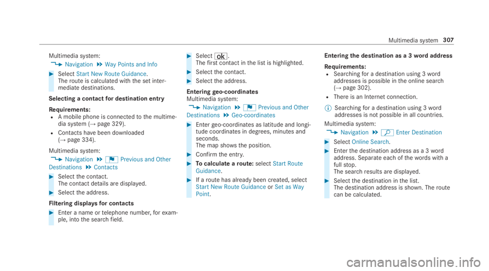
Multimedia system:
,Navigation.Way Points and Info
#SelectStart New Route Guidance.Theroute is calculated withthe set inter‐mediate destinations.
Selecting a contactfor destination entry
Requirements:RA mobile phone is connectedtothe multime‐dia system (→page 329).
RContacts havebeen downloaded(→page 334).
Multimedia system:
,Navigation.¬Previous and Other
Destinations.Contacts
#Selectthe contact.The contact details are displayed.
#Selectthe address.
Filtering displaysfor contacts
#Enter a name ortelephone number,forexam‐ple, intothe searchfield.
#Select¡.Thefirst contact inthe list is highlighted.
#Selectthe contact.
#Selectthe address.
Enteringgeo-coordinatesMultimedia system:
,Navigation.¬Previous and Other
Destinations.Geo-coordinates
#Entergeo-coordinates as latitude and longi‐tude coordinates in degrees, minutes andseconds.The map shows the position.
#Confirmthe entry.
#Tocalculate aroute:selectStart RouteGuidance.
#If aroute has already been created, selectStart New Route GuidanceorSet as WayPoint.
Enteringthe destination as a 3wordaddress
Requirements:RSearchingfor a destination using 3wordaddresses is possible inthe online search(→page 302).
RThere is an Internet connection.
%Searchingfor a destination using 3wordaddresses is not possible in all countries.
Multimedia system:
,Navigation.ªEnter Destination
#SelectOnline Search.
#Enterthe destination address as a 3wordaddress. Separate each ofthewords with afullstop.The searchresults are displayed.
#Selectthe destination inthe list.The destination address is shown. Theroutecan be calculated.
Multimedia system307
Page 310 of 578
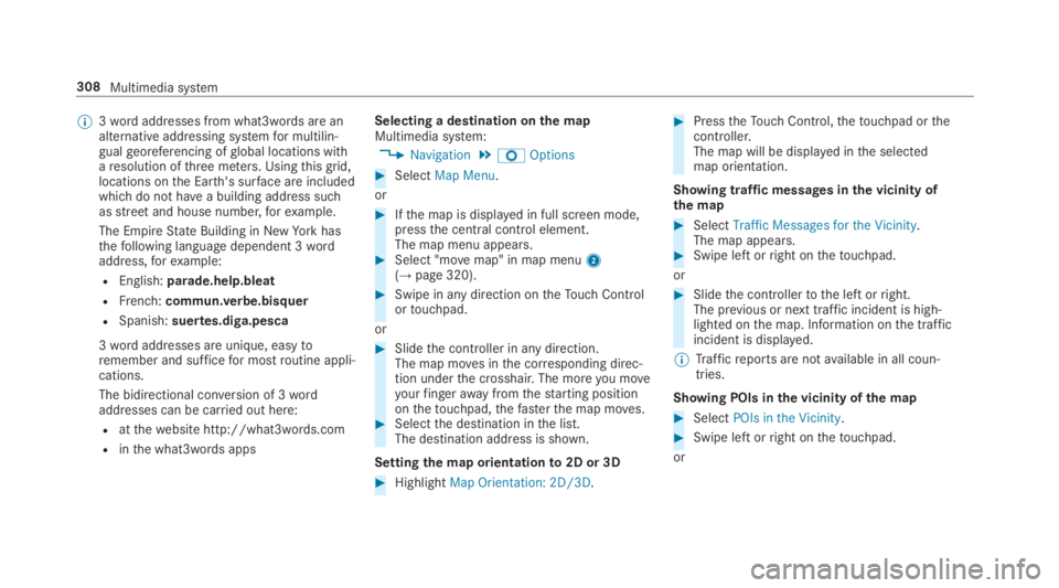
%3wordaddresses from what3words are analternative addressing systemfor multilin‐gualgeoreferencing ofglobal locations witharesolution ofthree meters. Usingthisgrid,locations onthe Earth's surface are includedwhichdo not havea building address suchasstreetand house number,forexample.
The EmpireState Building in NewYorkhasthefollowing language dependent 3wordaddress,forexample:
REnglish:parade.help.bleat
RFrench:commun.verbe.bisquer
RSpanish:suertes.diga.pesca
3wordaddresses are unique, easytoremember and sufficefor mostroutine appli‐cations.
The bidirectional conversion of 3wordaddresses can be carried out here:
Ratthewebsite http://what3words.com
Rinthe what3words apps
Selecting a destination onthe mapMultimedia system:
,Navigation.ZOptions
#SelectMap Menu.
or
#Ifthe map is displayed in full screen mode,pressthe central control element.The map menu appears.#Select "movemap" in map menu2(→page 320).
#Swipe in any direction ontheTouch Controlortouchpad.
or
#Slidethe controller in any direction.The map moves inthe corresponding direc‐tion underthe crosshair. The moreyou moveyourfingerawayfromthestarting positiononthetouchpad,thefasterthe map moves.#Selectthe destination inthe list.The destination address is shown.
Settingthe map orientationto2D or 3D
#HighlightMap Orientation: 2D/3D.
#PresstheTouch Control,thetouchpad orthecontroller.The map will be displayed inthe selectedmap orientation.
Showing traffic messages inthe vicinity ofthe map
#SelectTraffic Messages for the Vicinity.The map appears.#Swipe left orright onthetouchpad.
or
#Slidethe controllertothe left orright.The previous or next traffic incident is high‐lighted onthe map. Information onthe trafficincident is displayed.
%Trafficreports are notavailable in all coun‐tries.
Showing POIs inthe vicinity ofthe map
#SelectPOIs in the Vicinity.
#Swipe left orright onthetouchpad.
or
308Multimedia system
Page 311 of 578
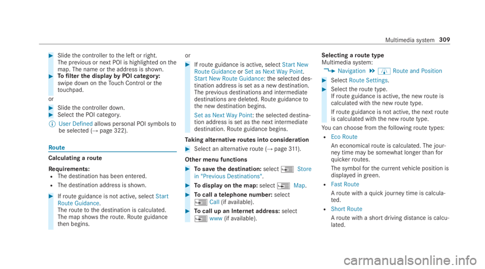
#Slidethe controllertothe left orright.The previous or next POI is highlighted onthemap. The name orthe address is shown.#Tofilterthe displaybyPOI category:swipe down ontheTouch Control orthetouchpad.
or
#Slidethe controller down.#Selectthe POI category.
%User Definedallowspersonal POI symbolstobe selected (→page 322).
Route
Calculating aroute
Requirements:RThe destination has been entered.
RThe destination address is shown.
#Ifroute guidance is not active, selectStartRoute Guidance.Theroutetothe destination is calculated.The map shows theroute.Route guidancethen begins.
or
#Ifroute guidance is active, selectStart NewRoute GuidanceorSet as Next Way Point.Start New Route Guidance:the selected des‐tination address is set as a new destination.The previous destinations and intermediatedestinations are deleted.Route guidancetothe new destination begins.
Set as Next Way Point:the selected destina‐tion address is set asthe next intermediatedestination.Route guidance begins.
Taking alternativeroutes into consideration
#Select an alternativeroute (→page311).
Other menu functions
#Tosavethe destination:select�
Page 315 of 578
Theroad and trafficrules andregulations alwayshavepriorityover multimedia system drivinginstructions.
Thefollowing driving instructions can be used:
RNavigation announcements
RRoute guidance displays
RLanerecommendations
Ifyou do notfollowthe driving instructions or ifyou leavethe calculatedroute, a newroute iscalculated automatically.
Driving instructions may differ fromthe actualroad and traffic conditions if:
RTheroute is diverted
RThe direction of a one-waystreethas beenchanged
Forthisreason,you must always observeroadand trafficrules andregulations duringyourjourney aswell asthe prevailing traffic condi‐tions.
Theroute may differ fromthe idealroute duetothefollowing:
RRoadworks
RIncompletedigital map data
Notes on GPSreceptionThe correct function ofthe navigation systemdepends amongstotherthings on GPSrecep‐tion. In certain situations GPSreception can beimpaired, defective oreven not possible, e.g. intunnels or in parkinggarages.
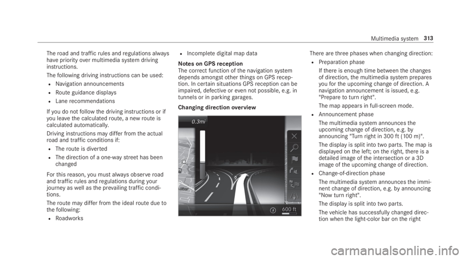
Changing directionoverview
There arethree phases whenchanging direction:
RPreparation phase
Ifthere is enough time betweenthechangesof direction,the multimedia system preparesyouforthe upcomingchange of direction. Anavigation announcement is issued, e.g."Preparetoturnright".
The map appears in full-screen mode.
RAnnouncement phase
The multimedia system announcestheupcomingchange of direction, e.g.byannouncing "Turnright in 300ft(100 m)".
The display is split into two parts. The map isdisplayed onthe left;ontheright,there is adetailed image ofthe intersection or a 3Dimage ofthe upcomingchange of direction.
RChange-of-direction phase
The multimedia system announcesthe immi‐nentchange of direction, e.g.byannouncing"Now turnright".
The display is split into two parts.
Thevehicle has successfullychanged direc‐tion whenthe light-color bar ontheright
Multimedia system313
Page 316 of 578
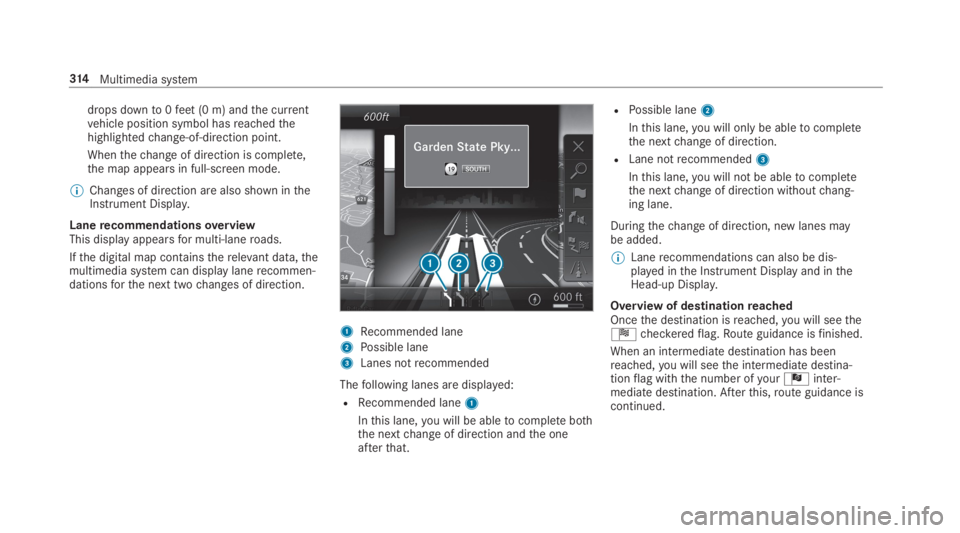
drops downto0feet(0 m) andthe currentvehicle position symbol hasreachedthehighlightedchange-of-direction point.
Whenthechange of direction is complete,the map appears in full-screen mode.
%Changes of direction are also shown intheInstrument Display.
LanerecommendationsoverviewThis display appearsfor multi-laneroads.
Ifthe digital map containstherelevant data,themultimedia system can display lanerecommen‐dationsforthe next twochanges of direction.
1Recommended lane
2Possible lane
3Lanes notrecommended
Thefollowing lanes are displayed:
RRecommended lane1
Inthis lane,you will be abletocomplete boththe nextchange of direction andthe oneafterthat.
RPossible lane2
Inthis lane,you will onlybe abletocompletethe nextchange of direction.
RLane notrecommended3
Inthis lane,you will not be abletocompletethe nextchange of direction withoutchang‐ing lane.
Duringthechange of direction, new lanes maybe added.
%Lanerecommendations can also be dis‐played inthe Instrument Display and intheHead-up Display.
Overview of destinationreachedOncethe destination isreached,you will seetheÍcheckeredflag.Route guidance isfinished.
When an intermediatedestination has beenreached,you will seethe intermediate destina‐tionflag withthe number ofyourÎinter‐mediate destination. Afterthis,route guidance iscontinued.
314Multimedia system
Page 319 of 578
Whenthevehicle is off-road,thefollowing dis‐playsare shown:
RtheRoad Not Mappedmessage
Ra direction arrowshowingthe linear directiontothe POI
Whenthevehicle is back on aroad knowntothemultimedia system,route guidance continues asnormal.
Destination
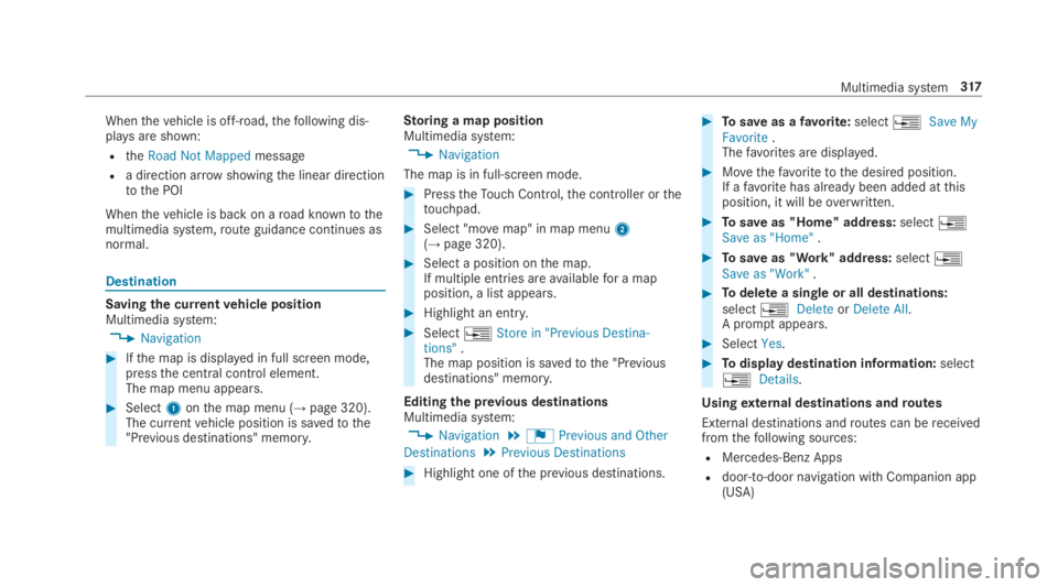
Saving the currentvehicle positionMultimedia system:
,Navigation
#Ifthe map is displayed in full screen mode,pressthe central control element.The map menu appears.
#Select1onthe map menu (→page 320).The currentvehicle position is savedtothe"Previous destinations" memory.
Storing a map positionMultimedia system:
,Navigation
The map is in full-screen mode.
#PresstheTouch Control,the controller orthetouchpad.
#Select "movemap" in map menu2(→page 320).
#Select a position onthe map.If multiple entries areavailablefor a mapposition, a list appears.
#Highlight an entry.
#Select�