Page 217 of 268

— If you calculate a route on a main road, thestarting point of the route may not exactly
match the current vehicle location.
— The endpoint of the route may not exactly match the destination.
— If you calculate a route on a main road, the system may display a route from another
main road. This may be because the
position of the vehicle icon is not accu-
rate. In this case, park the vehicle in a safe
location and reset the vehicle icon, or
continue driving to see if the position of
the vehicle icon is automatically adjusted
before recalculating the route.
— There are cases in which the system shows an indirect route to reach the
destination or waypoints, if you set them
from stored or facility information. In order
to correct this, you must be careful about
the traffic direction, especially when lanes
with different travel directions are shown
separately, such as interchanges and
service areas.
— This system makes no distinction be- tween limited traffic control and total
control (blockage) . It may show an
indirect route even if the road is usable. — Even if the ferry preference is set to OFF, a
route that uses a ferry line may be
suggested.ROUTE GUIDANCE
INFO:
The system will announce street names when the
system language is set to English. Street names
are not announced when the system is set to
French/Spanish.
REPEATING VOICE GUIDANCE
This function is available throughout route
guidance, from the time after the route calcula-
tion is completed until the vehicle arrives at the
destination. Push and hold the
Page 218 of 268

.Voice guidance is activated only for inter-
sections with certain conditions. There may
be cases where the vehicle has to turn, but
voice guidance is not provided.
. Voice guidance contents may vary, depend-
ing on the direction of the turn and the type of
intersection.
. The voice guidance timing will vary depend-
ing on the situation.
. When the vehicle has deviated from the
suggested route, voice guidance is not
available. The system will not announce this.
Refer to the map and recalculate the route.
“Recalculating route” (page 3-42)
. Voice guidance may not accurately corre-
spond with road numbers and directions at
freeway junctions.
. Voice guidance may not accurately corre-
spond to street names at freeway exits.
. The displayed street names may sometimes
differ from the actual names.
. Voice guidance is not available when the
[Guidance Voice] is turned off.
“Volume and Beeps settings”
(page 1-16) .
Voice guidance will start when the vehicle
enters the suggested route. Refer to the map
for directions to the starting point of the
route.
. When approaching a waypoint, voice gui-
dance will announce, “You have arrived at
waypoint 1 (2, 3, 4,...) .” Voice guidance will
switch to the next section of the route. When
voice guidance is not available, refer to the
map for directions.
. In some cases, voice guidance ends before
arrival at the destination. Refer to the
destination icon on the map to reach the
destination.
. If the system recognizes on which side the
destination (waypoint) is located, voice
guidance will announce “on the right/left”
after announcing the arrival at the destina-
tion.
. Voice guidance may be partially operational
or inoperative due to the angle of roads at an
intersection.
. Because freeway lane information is avail-
able only for approximately 7,000 major
freeways in North America, it is not possible
to display information for all junctions and
exits. .
Freeway exit information may differ from the
information on the actual exit signs.
. Because it is not possible to consider data
concerning roads that are seasonally avail-
able or unavailable, a route may be displayed
that does not match the actual traffic
restrictions. Be sure to follow the actual
traffic restrictions while driving.
. Canada and Alaska contain many roads with
incomplete map data. As a result, when
searching for a route, the route may include
roads with incomplete data. In regions where
road data is not complete, voice guidance
may stop for long periods of time. Be sure to
follow the actual traffic restrictions while
driving.
9-8
9. General system information
Page 219 of 268

MAP DATA
HOW TO HANDLE THE MAP SD
CARD
An SD card that includes the map data is
inserted. When handling the Map SD card,
please be careful and adhere to the following
instructions: . An SD card is inserted in the slot. This is the
SDHC card that is exclusively used for this
device. This card includes the map data. The
SDHC card is necessary to operate the
device. Do not remove this card except when
updating the map data is required.
. Never analyze, modify, delete or format the
map data. Doing so may cause an improper
operation of the device.
. The SDHC card that is exclusively used for
this device does not work properly if it is
inserted in another device.
. The map data cannot be used even if it is
copied to another SDHC card.
. Do not remove the SDHC card containing
map data from the system. Using the system
with the SDHC card containing map data
removed will prevent some functions from
operating.
NOTE:
Do not remove the SD card containing map
data that is inserted in the slot. When this
SD card containing map data is removed
the navigation system will not operate. If
the SD card containing map data is acci-
dentally removed, after reinserting the SD
card containing map data into the slot,
place the power switch in the OFF position
and then place it back in the ON position.
HOW TO ORDER MAP DATA UP-
DATES
Visit NissanNavigation.com or contact the
NISSAN NAVIGATION SYSTEM HELPDESK
to order updated map data. (See the contact
information on the inside front cover of this
manual.)
ABOUT MAP DATA
1. This map data has been prepared by CLARION CO., LTD. (CLARION) , under
license from HERE. has added, processed
and digitized data based on the digital road
map data of HERE. Due to the production
timing of the map data, some new roads may
not be included in this map data or some of
the names or roads may be different from
those at the time you use this map data. 2. Traffic control and regulation data used in
this map data may be different from those at
the time you use this map data due to the
data production timing. When driving your
vehicle, follow the actual traffic control signs
and notices on the roads.
3. Reproducing or copying this map software is strictly prohibited by law.
Published by Nissan North America, Inc.
*
C2012 HERE. All Rights Reserved.
*
CZENRIN CO., LTD.2013. All rights reserved.
Certain business data provided by Infogroup *
C
2012, All Rights Reserved.
WARNING
.This navigation system should not be
used as a substitute for your own
judgement. Any route suggestions
made by this navigation system may
never override any local traffic reg-
ulations, your own judgement, and/
or knowledge of safe driving prac-
tices. Disregard route suggestions by
the navigation system if such sugges-
tions would: cause you to perform an
hazardous or illegal maneuver, place
you in an hazardous situation, or
route you into an area you consider
9-9
9. General system information
Page 220 of 268

unsafe.
. The advice provided by the naviga-
tion system is to be regarded only as
a suggestion. There may be situa-
tions where the navigation system
displays the vehicle’s location incor-
rectly, fails to suggest the shortest
course, and/or fails to direct you to
your desired destination. In such
situations, rely on your own driving
judgement, taking into account cur-
rent driving conditions.
. Do not use the navigation system to
route you to emergency services. The
database does not contain a com-
plete listing of locations of emer-
gency service providers such as
police, fire stations, hospitals and
clinics. Please use your judgement
and your ability to ask for directions
in these situations.
. As the driver you solely are respon-
sible for your driving safety.
— In order to avoid traffic accidents, do not operate the system while
driving. — In order to avoid traffic accidents,
operate the system only when the
vehicle is stopped at a safe place
and the parking brake is set.
— In order to avoid traffic accidents or traffic offence, remember that
actual road conditions and traffic
regulations take precedence over
the information contained on the
navigation system.
— Accordingly, the Software may contain inaccurate or incomplete
information due the passage of
time, changing circumstances, and
due to the nature of the sources
used. Please observe the actual
traffic circumstances and regula-
tions at all times while driving.
— In a situation when actual road conditions and traffic regulations
differ from the information con-
tained on the navigation system,
then abide by traffic rules.
— The navigation system does not provide, or account for in any way,
information regarding traffic and
road laws; speed restrictions; road
conditions including road slope, grade, and/or surface conditions;
obstruction information including
bridge and tunnel height and
width, and/or other prevailing driv-
ing and/or road conditions. Always
rely on your own driving judgment,
taking into account current driving
conditions.
— Minimize the amount of time spent viewing the screen while driving.
The marks of companies displayed by this
product to indicate business locations are the
marks of their respective owners. The use of
such marks in this product does not imply any
sponsorship, approval, or endorsement by such
companies of this product.
END-USER TERMS
The data (“Data”) is provided for your personal,
internal use only and not for resale. It is protected
by copyright, and is subject to the following
terms and conditions which are agreed to by you,
on the one hand, and CLARION CO., LTD.
(“CLARION”) and its licensors (including their
licensors and suppliers) on the other hand.
*
C2012 HERE. All rights reserved.
This data includes information taken with permis-
9-10
9. General system information
Page 221 of 268

sion from Canadian authorities, including*CHer
Majesty, *CQueen’s Printer for Ontario, *C
Canada Post, GeoBase�Š,*CDepartment of
Natural Resources Canada. All rights reserved.
HERE holds a non-exclusive license from the
United States Postal Service
�Što publish and sell
ZIP+4�Šinformation.
*
CUnited States Postal Service�Š2012. Prices
are not established, controlled or approved by
the United States Postal Service
�Š. The following
trademarks and registrations are owned by the
USPS: United States Postal Service, USPS, and
ZIP+4.
Terms and conditions
Personal Use Only. You agree to use this Data
together with Nissan Automotive Products for
the solely personal, non-commercial purposes
for which you were licensed, and not for service
bureau, time-sharing or other similar purposes.
Accordingly, but subject to the restrictions set
forth in the following paragraphs, you agree not
to otherwise reproduce, copy, modify, decom-
pile, disassemble or reverse engineer any portion
of this Data, and may not transfer or distribute it
in any form, for any purpose, except to the extent
permitted by mandatory laws. Multi-disc sets
may only be transferred or sold as a complete set
as provided by CLARION and not as a subset
thereof.
Restrictions.Except where you have been
specifically licensed to do so by CLARION, and
without limiting the preceding paragraph, you
may not (a) use this Data with any products,
systems, or applications installed or otherwise
connected to or in communication with vehicles,
capable of vehicle navigation, positioning, dis-
patch, real time route guidance, fleet manage-
ment or similar applications; or (b) with or in
communication with any positioning devices or
any mobile or wireless-connected electronic or
computer devices, including without limitation
cellular phones, palmtop and handheld compu- ters, pagers, and personal digital assistants or
PDAs.
Warning.The Data may contain inaccurate or
incomplete information due to the passage of
time, changing circumstances, sources used and
the nature of collecting comprehensive geo-
graphic data, any of which may lead to incorrect
results.
No Warranty.This Data is provided to you “as
is,” and you agree to use it at your own risk.
CLARION and its licensors (and their licensors
and suppliers) make no guarantees, representa-
tions or warranties of any kind, express or
implied, arising by law or otherwise, including
but not limited to, content, quality, accuracy,
completeness, effectiveness, reliability, fitness
for a particular purpose, usefulness, use or
results to be obtained from this Data, or that
the Data or server will be uninterrupted or error-
free.
Disclaimer of Warranty:
CLARION AND ITS
LICENSORS (INCLUDING THEIR LICENSORS
AND SUPPLIERS) DISCLAIM ANY WARRAN-
TIES, EXPRESS OR IMPLIED, OF QUALITY,
PERFORMANCE, MERCHANTABILITY, FIT-
NESS FOR A PARTICULAR PURPOSE OR
NON-INFRINGEMENT. Some States, Territories
and Countries do not allow certain warranty
exclusions, so to that extent the above exclusion
9-11
9. General system information
Page 222 of 268
 SHALL NOT BE LIABLE TO
YOU: IN RESPECT OF ANY CLAIM, DEMAND
OR ACTION, IRRESPECTIVE OF")
may not apply to you.
Disclaimer of Liability:CLARION AND ITS
LICENSORS (INCLUDING THEIR LICENSORS
AND SUPPLIERS) SHALL NOT BE LIABLE TO
YOU: IN RESPECT OF ANY CLAIM, DEMAND
OR ACTION, IRRESPECTIVE OF THE NATURE
OF THE CAUSE OF THE CLAIM, DEMAND OR
ACTION ALLEGING ANY LOSS, INJURY OR
DAMAGES, DIRECT OR INDIRECT, WHICH
MAY RESULT FROM THE USE OR POSSES-
SION OF THE INFORMATION; OR FOR ANY
LOSS OF PROFIT, REVENUE, CONTRACTS
OR SAVINGS, OR ANY OTHER DIRECT,
INDIRECT, INCIDENTAL, SPECIAL OR CON-
SEQUENTIAL DAMAGES ARISING OUT OF
YOUR USE OF OR INABILITY TO USE THIS
INFORMATION, ANY DEFECT IN THE INFOR-
MATION, OR THE BREACH OF THESE TERMS
OR CONDITIONS, WHETHER IN AN ACTION
IN CONTRACT OR TORT OR BASED ON A
WARRANTY, EVEN IF CLARION OR ITS
LICENSORS HAVE BEEN ADVISED OF THE
POSSIBILITY OF SUCH DAMAGES. Some
States, Territories and Countries do not allow
certain liability exclusions or damages limitations,
so to that extent the above may not apply to you.
Export Control. CLARION shall not export from
anywhere any part of the Data or any direct
product thereof except in compliance with, and with all licenses and approvals required under,
applicable export laws, rules and regulations,
including but not limited to the laws, rules and
regulations administered by the Office of Foreign
Assets Control of the U.S. Department of
Commerce and the Bureau of Industry and
Security of the U.S. Department of Commerce.
To the extent that any such export laws, rules or
regulations prohibit NT from complying with any
of its obligations hereunder to deliver or dis-
tribute Data, such failure shall be excused and
shall not constitute a breach of this Agreement.
Entire Agreement.These terms and conditions
constitute the entire agreement between CLAR-
ION (and its licensors, including their licensors
and suppliers) and you pertaining to the subject
matter hereof, and supersedes in their entirety
any and all written or oral agreements previously
existing between us with respect to such subject
matter.
Governing Law.
The above terms and condi-
tions shall be governed by the laws of the State
of Illinois, without giving effect to (i) its conflict of
laws provisions, or (ii) the United Nations
Convention for Contracts for the International
Sale of Goods, which is explicitly excluded. You
agree to submit to the jurisdiction of the State of
Illinois for any and all disputes, claims and
actions arising from or in connection with the Data provided to you hereunder.
Government End Users.
If the Data is being
acquired by or on behalf of the United States
government or any other entity seeking or
applying rights similar to those customarily
claimed by the United States government, the
Data is a “commercial item” as that term is
defined at 48 C.F.R. (“FAR”) 2.101, is licensed in
accordance with the End-User Terms under
which this Data was provided, and each copy
of the Data delivered or otherwise furnished shall
be marked and embedded as appropriate with
the following “Notice of Use,” and shall be
treated in accordance with such Notice:
NOTICE OF USE
CONTRACTOR (MANUFACTURER/ SUPPLIER) NAME: HERE
CONTRACTOR (MANUFACTURER/SUPPLIER) ADDRESS:
c/o Nokia 425 West Randolph Street, Chicago, Illinois 60606
This Data is a commercial item as defined in FAR
2.101 and is subject to the End-User Terms under which this Data was provided.
*
C2012 HERE – All rights reserved.
If the Contracting Officer, federal government
agency, or any federal official refuses to use the
9-12
9. General system information
Page 223 of 268

legend provided herein, the Contracting Officer,
federal government agency, or any federal official
must notify HERE prior to seeking additional or
alternative rights in the Data.HOW TO HANDLE DISPLAY
The display is a liquid crystal display and should
be handled with care.
WARNING
Never disassemble the display. Some
parts utilize extremely high voltage.
Touching them may result in serious
personal injury.
CHARACTERISTICS OF LIQUID
CRYSTAL DISPLAY
.If the temperature inside the vehicle is
especially low, the display will stay relatively
dim or the movement of the images may be
slow. These conditions are normal. The
display will function normally when the
interior of the vehicle has warmed up.
. Some pixels in the display are darker or
brighter than others. This condition is an
inherent characteristic of liquid crystal dis-
plays, and it is not a malfunction.
. A remnant of the previous display image may
remain on the screen. This screen burn is
inherent in displays, and it is not a malfunc-
tion. .
The screen may become distorted by strong
magnetic fields.
MAINTENANCE OF DISPLAY
CAUTION
.To clean the display screen, use a dry,
soft cloth. If additional cleaning is
necessary, use a small amount of
neutral detergent with a soft cloth.
. Clean the display with the power
switch in the OFF position. If the
display is cleaned while the power
switch is placed in the ON position or
when the READY to drive indicator
light is on, unintentional operation
may occur.
. To clean the display, never use a
rough cloth, alcohol, benzine, thinner
or any kind of solvent or paper towel
with a chemical cleaning agent. They
will scratch or deteriorate the panel.
. Do not splash any liquid such as
water or car fragrance on the display.
Contact with liquid will cause the
system to malfunction.
To clean the display screen, use a dry, soft cloth.
9-13
9. General system information
Page 224 of 268

If additional cleaning is necessary, use a small
amount of neutral detergent with a soft cloth.
Never spray the screen with water or detergent.
Dampen the cloth first, then wipe the screen.HOW TO HANDLE THE SD CARD
When handling the SD card, please be careful
and adhere to the following instructions:. Always follow the instructions described in
this manual and in the handbook attached to
the SD card when using an SD card in this
device.
. Do not handle an SD card with wet hands.
Doing so may cause electric shock or a
malfunction.
. Do not allow hands or metal objects to
contact the terminal area of SD cards.
. Do not place SD cards on the instrument
panel, on any place with direct sunlight or in
moist circumstances. Doing so may damage
or deform the SD card.
. Do not use any conventional cleaner, ben-
zine, thinner or antistatic spray.
. Do not use SD cards in any place where
static electricity or electric noise adversely
affects SD cards. This may cause data
corruption or data loss.
. SD card optimization must not be performed.
. Always place the SD card in its storage case
when not in use. .
If an SD card is disposed of when it is not
used, it is recommended not only to delete
the stored data but also to physically break
the card.
9-14
9. General system information
 1
1 2
2 3
3 4
4 5
5 6
6 7
7 8
8 9
9 10
10 11
11 12
12 13
13 14
14 15
15 16
16 17
17 18
18 19
19 20
20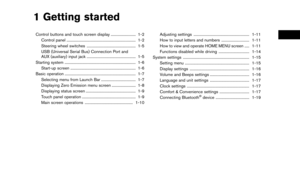 21
21 22
22 23
23 24
24 25
25 26
26 27
27 28
28 29
29 30
30 31
31 32
32 33
33 34
34 35
35 36
36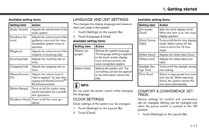 37
37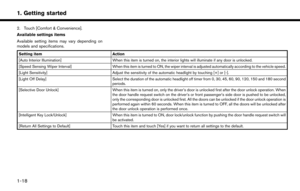 38
38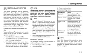 39
39 40
40 41
41 42
42 43
43 44
44 45
45 46
46 47
47 48
48 49
49 50
50 51
51 52
52 53
53 54
54 55
55 56
56 57
57 58
58 59
59 60
60 61
61 62
62 63
63 64
64 65
65 66
66 67
67 68
68 69
69 70
70 71
71 72
72 73
73 74
74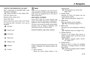 75
75 76
76 77
77 78
78 79
79 80
80 81
81 82
82 83
83 84
84 85
85 86
86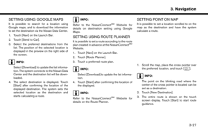 87
87 88
88 89
89 90
90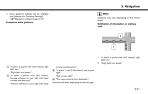 91
91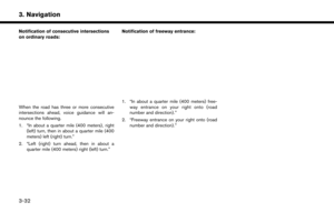 92
92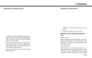 93
93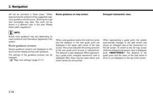 94
94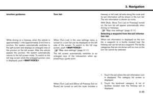 95
95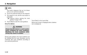 96
96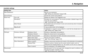 97
97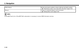 98
98 99
99 100
100 101
101 102
102 103
103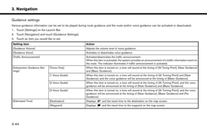 104
104 105
105 106
106 107
107 108
108 109
109 110
110 111
111 112
112 113
113 114
114 115
115 116
116 117
117 118
118 119
119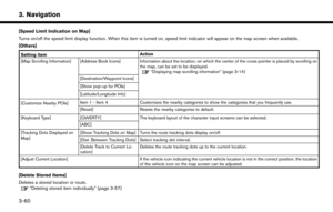 120
120 121
121 122
122 123
123 124
124 125
125 126
126 127
127 128
128 129
129 130
130 131
131 132
132 133
133 134
134 135
135 136
136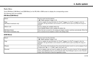 137
137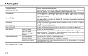 138
138 139
139 140
140 141
141 142
142 143
143 144
144 145
145 146
146 147
147 148
148 149
149 150
150 151
151 152
152 153
153 154
154 155
155 156
156 157
157 158
158 159
159 160
160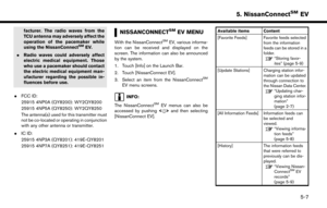 161
161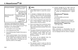 162
162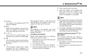 163
163 164
164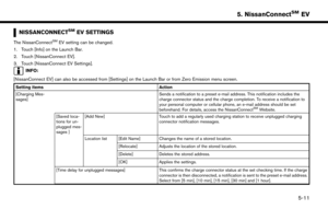 165
165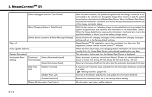 166
166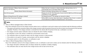 167
167 168
168 169
169 170
170 171
171 172
172 173
173 174
174 175
175 176
176 177
177 178
178 179
179 180
180 181
181 182
182 183
183 184
184 185
185 186
186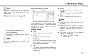 187
187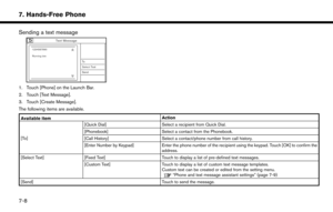 188
188 189
189 190
190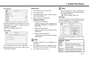 191
191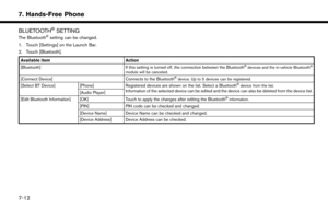 192
192 193
193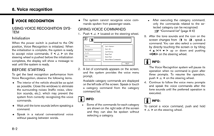 194
194 195
195 196
196 197
197 198
198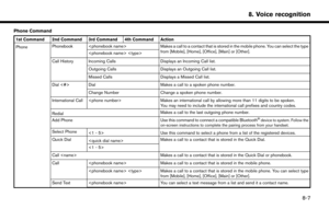 199
199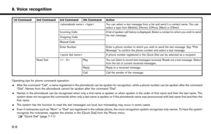 200
200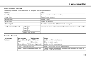 201
201 202
202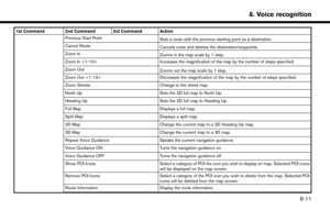 203
203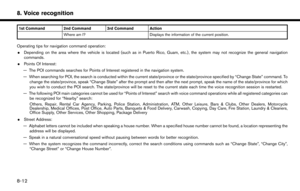 204
204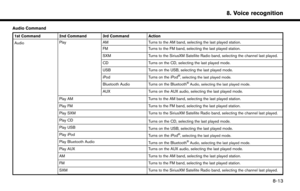 205
205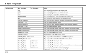 206
206 207
207 208
208 209
209 210
210 211
211 212
212 213
213 214
214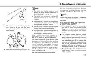 215
215 216
216 217
217 218
218 219
219 220
220 221
221 222
222 223
223 224
224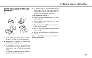 225
225 226
226 227
227 228
228 229
229 230
230 231
231 232
232 233
233 234
234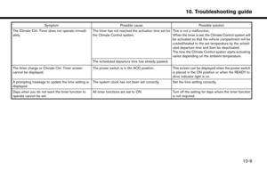 235
235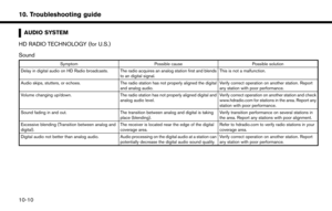 236
236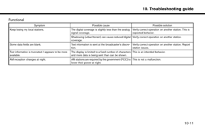 237
237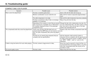 238
238 239
239 240
240 241
241 242
242 243
243 244
244 245
245 246
246 247
247 248
248 249
249 250
250 251
251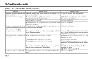 252
252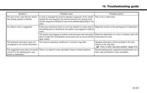 253
253 254
254 255
255 256
256 257
257 258
258 259
259 260
260 261
261 262
262 263
263 264
264 265
265 266
266 267
267