2017 NISSAN LEAF display
[x] Cancel search: displayPage 86 of 268
Voice command
1. Push <
>located on the steering wheel.
2. After the tone sounds, speak a command.
Use the following voice command to set city
center as a destination:
“City Center”*
*: This voice command operation is available only
when the language setting is in English.
SETTING FREEWAY ENTRANCE/
EXIT
It is possible to set the destination to an entrance
or exit of a freeway.
1. Touch [Navi] on the Launch Bar.
2. Touch [Freeway Entrance/Exit] to display the keyboard input screen.
3. Enter the name of the freeway. After finishing entry, touch [List].
4. Touch the preferred freeway.
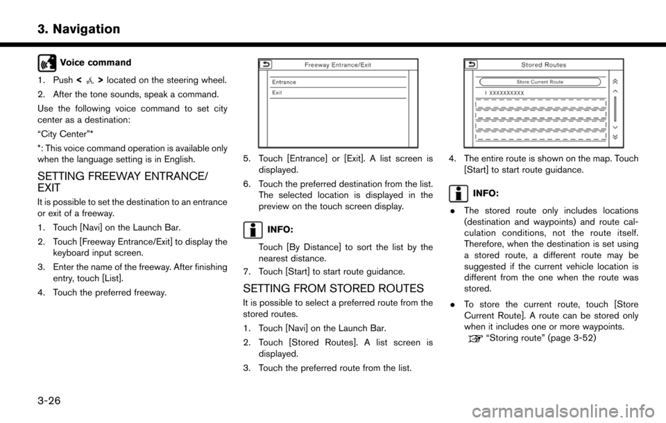
5. Touch [Entrance] or [Exit]. A list screen is displayed.
6. Touch the preferred destination from the list. The selected location is displayed in the
preview on the touch screen display.
INFO:
Touch [By Distance] to sort the list by the
nearest distance.
7. Touch [Start] to start route guidance.
SETTING FROM STORED ROUTES
It is possible to select a preferred route from the
stored routes.
1. Touch [Navi] on the Launch Bar.
2. Touch [Stored Routes]. A list screen is displayed.
3. Touch the preferred route from the list.
4. The entire route is shown on the map. Touch [Start] to start route guidance.
INFO:
. The stored route only includes locations
(destination and waypoints) and route cal-
culation conditions, not the route itself.
Therefore, when the destination is set using
a stored route, a different route may be
suggested if the current vehicle location is
different from the one when the route was
stored.
. To store the current route, touch [Store
Current Route]. A route can be stored only
when it includes one or more waypoints.
“Storing route” (page 3-52)
3-26
3. Navigation
Page 87 of 268
![NISSAN LEAF 2017 1.G Navigation Manual SETTING USING GOOGLE MAPS
It is possible to search for a location using
Google maps, and to download the information
to set the destination via the Nissan Data Center.
1. Touch [Navi] on the Launch Ba NISSAN LEAF 2017 1.G Navigation Manual SETTING USING GOOGLE MAPS
It is possible to search for a location using
Google maps, and to download the information
to set the destination via the Nissan Data Center.
1. Touch [Navi] on the Launch Ba](/manual-img/5/531/w960_531-86.png)
SETTING USING GOOGLE MAPS
It is possible to search for a location using
Google maps, and to download the information
to set the destination via the Nissan Data Center.
1. Touch [Navi] on the Launch Bar.
2. Touch [Send to Car].
3. Select the preferred destinations from thelist. The position of the selected location is
displayed in the preview on the right side of
the screen.
INFO:
Select [Download] to update the list informa-
tion. The system connects to the Nissan Data
Center and the destination list will be down-
loaded.
4. The select destination is displayed. Touch [Start] after confirming the location of the
displayed destination. The system sets the
selected location as the destination and
starts calculating a route.
INFO:
Refer to the NissanConnect
SMWebsite for
details on destination setting using Google
Maps.
SETTING USING ROUTE PLANNER
It is possible to set a route according to the route
plan created in advance at the NissanConnectSM
Website.
1. Touch [Navi] on the Launch Bar.
2. Touch [Route Planner].
3. Touch a preferred route plan.
INFO:
Select [Download] to update the list informa-
tion.
4. Touch [Start] after confirming the location of the displayed.
INFO:
Refer to the NissanConnect
SMWebsite for
details on the Route Planner.
SETTING POINT ON MAP
It is possible to set a location scrolled to on the
map as the destination and have the system
calculate a route.
1. Scroll the map, place the cross pointer over the preferred location, and touch [].
INFO:
The point on the blinking road where the
center of the cross pointer is located can be
set as a destination.
2. Touch [New Destination].
3. The entire route is shown on the touch screen display. Touch [Start] to start route
guidance.
3-27
3. Navigation
Page 88 of 268
INFO:
If a point on a freeway is set as the destination, a
confirmation message is displayed.
SETTING WITH NISSANCON-
NECTSMEV
It is possible to set the destination using the
NissanConnectSMEV features.“NissanConnectSMEV menu” (page 5-7)
INFO:
Use of NissanConnect
SMEV features is depen-
dent upon a valid subscription and the telematics
device being in operative condition, as well as
cellular connectivity, navigation map data and
GPS satellite signal reception being available.
Setting from information feeds
If the downloaded NissanConnectSMEV infor-
mation feed has location data, you can set it as a
destination. It is also possible to use Nissan-
Connect
SMEV features such as “Send to Car” or
“Route Planner”, etc. to set a destination.
1. Touch [Info] on the Launch Bar.
2. Touch [NissanConnect EV].
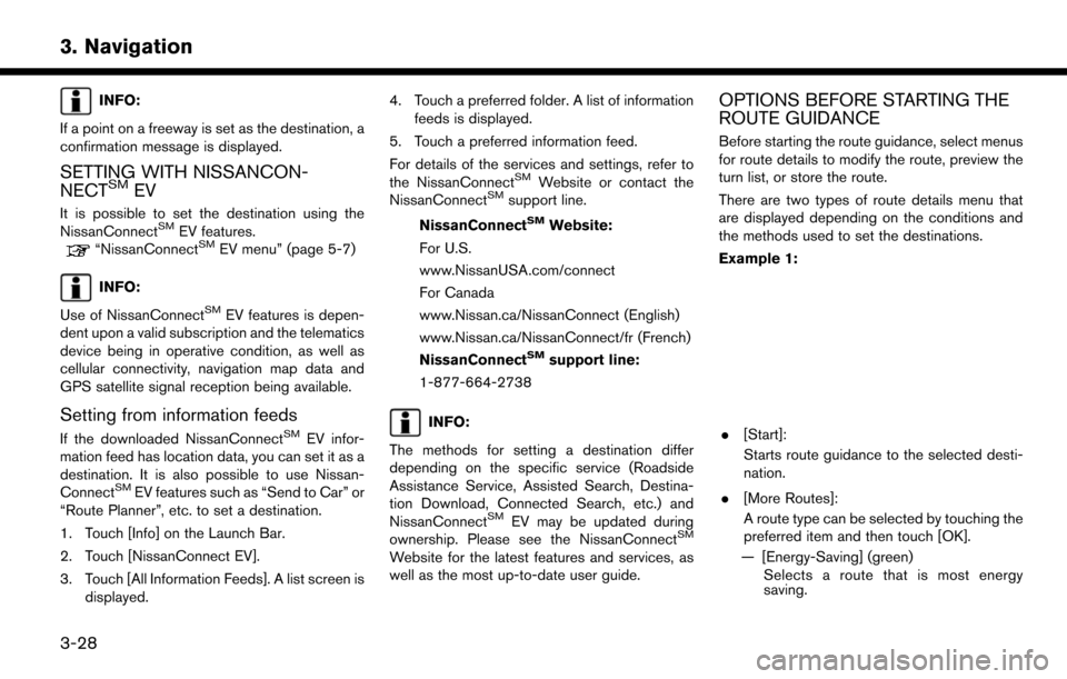
3. Touch [All Information Feeds]. A list screen is displayed. 4. Touch a preferred folder. A list of information
feeds is displayed.
5. Touch a preferred information feed.
For details of the services and settings, refer to
the NissanConnect
SMWebsite or contact the
NissanConnectSMsupport line.
NissanConnect
SMWebsite:
For U.S.
www.NissanUSA.com/connect
For Canada
www.Nissan.ca/NissanConnect (English)
www.Nissan.ca/NissanConnect/fr (French)
NissanConnect
SMsupport line:
1-877-664-2738
INFO:
The methods for setting a destination differ
depending on the specific service (Roadside
Assistance Service, Assisted Search, Destina-
tion Download, Connected Search, etc.) and
NissanConnect
SMEV may be updated during
ownership. Please see the NissanConnectSM
Website for the latest features and services, as
well as the most up-to-date user guide.
OPTIONS BEFORE STARTING THE
ROUTE GUIDANCE
Before starting the route guidance, select menus
for route details to modify the route, preview the
turn list, or store the route.
There are two types of route details menu that
are displayed depending on the conditions and
the methods used to set the destinations.
Example 1:
. [Start]:
Starts route guidance to the selected desti-
nation.
. [More Routes]:
A route type can be selected by touching the
preferred item and then touch [OK].
— [Energy-Saving] (green) Selects a route that is most energy
saving.
3-28
3. Navigation
Page 89 of 268
![NISSAN LEAF 2017 1.G Navigation Manual — [Fastest] (purple)Selects a route that is shortest in time.
— [Min. FWY] (orange) Selects a route with minimum use of
freeways.
— [Short. Dist.] (pink) Selects a route that is shortest in
dist NISSAN LEAF 2017 1.G Navigation Manual — [Fastest] (purple)Selects a route that is shortest in time.
— [Min. FWY] (orange) Selects a route with minimum use of
freeways.
— [Short. Dist.] (pink) Selects a route that is shortest in
dist](/manual-img/5/531/w960_531-88.png)
— [Fastest] (purple)Selects a route that is shortest in time.
— [Min. FWY] (orange) Selects a route with minimum use of
freeways.
— [Short. Dist.] (pink) Selects a route that is shortest in
distance.
. [Route Info]:
Route Information such as turn list and
scrolled map can be displayed. The route
can also be saved for future use.
. [Add Way Pt.]:
Route can be edited by adding a destination
or a waypoint.
— If a waypoint is added, 3 alternative routes cannot be selected.
— It is possible to edit or add a destination or waypoints to the route that is already set.
“Editing route” (page 3-39)
INFO:
. Battery power information is displayed on the
screen after [More Routes] is touched. The
remaining battery power estimation function
cannot be used to confirm condition
changes that arise after driving starts. Utilize
the function as a reference when selecting
driving routes.
. After starting to drive, refer to the driving
range on the meter and perform battery
charging allowing for some leeway.
. In the following instances, the actual battery
power may differ from the remaining battery
power estimation.
— Frequent repetition of sudden accelera- tion and sudden braking
— Change of air conditioner operating con- ditions — Change of traffic conditions and driving
routes that differ from the one used for the
estimation
— Strong wind, cold, and snow weather conditions
— Tires that do not comply with specifica- tions, low air pressure tires, worn tires,
studless tires, and others.
— Decreased capacity of the Li-ion battery
— Installation of equipment that does not comply with specifications (carriers and
others)
. Choosing different route search conditions
in [More Routes] may not always generate
results search for different routes.
Example 2:
. [Start]:
Starts route guidance to the selected desti-
3-29
3. Navigation
Page 90 of 268
![NISSAN LEAF 2017 1.G Navigation Manual nation.
. [Route Details]:
Displays information of the route and allows
the route to be edited.
The menu shown in Example 1 is displayed.
. [Move Location]:
Displays a map screen and allows the
locati NISSAN LEAF 2017 1.G Navigation Manual nation.
. [Route Details]:
Displays information of the route and allows
the route to be edited.
The menu shown in Example 1 is displayed.
. [Move Location]:
Displays a map screen and allows the
locati](/manual-img/5/531/w960_531-89.png)
nation.
. [Route Details]:
Displays information of the route and allows
the route to be edited.
The menu shown in Example 1 is displayed.
. [Move Location]:
Displays a map screen and allows the
location of the destination to be adjusted.
. [Add to Route]:
Adds a location to the route previously set.
. [Save Location]:
Saves the location in the Address Book.
. [Details]:
Displays detailed information of the destina-
tion. Touch [Show Map] to display the map
around the destination. Touch [Call] (when
available) to make a phone call to the facility
set as a destination.ROUTE GUIDANCE
ABOUT ROUTE GUIDANCE
After setting the route, select [Start] to start the
route guidance.
Throughout the route guidance, the system
navigates you through the guide points using
visual and voice guidance.
WARNING
. The navigation system’s visual and
voice guidance is for reference pur-
poses only. The contents of the
guidance may be inappropriate de-
pending on the situation.
. Follow all traffic regulations when
driving along the suggested route
(e.g., one-way traffic) .
“Route guidance” (page 9-7)
Voice guidance during route guidance
Basics of voice guidance:
Voice guidance announces which direction to
turn when approaching an intersection for which
a turn is necessary.
INFO:
. There may be some cases in which voice
guidance and actual road conditions do not
correspond. This may occur because of
discrepancies between the actual road and
the information on the map data, or may also
be due to the vehicle speed.
. In case voice guidance does not correspond
to the actual road conditions, follow the
information obtained from traffic signs or
notices on the road.
. Route guidance provided by the navigation
system does not take carpool lane driving
into consideration, especially when carpool
lanes are separated from other road lanes.
. The system will announce street names
when the system language is set to English.
Street names are not announced when the
system is set to French or Spanish.
INFO:
. When approaching a guide point (intersec-
tion or corner) , destination, etc. during route
guidance, voice guidance announces the
remaining distance and/or turning direction.
Push and hold
Page 94 of 268
will not be provided in these areas.” When
approaching the endpoint of the suggested road,
voice guidance will announce, “Entering the road
with incomplete map data. The route will be
shown in a different color in this area. Please
follow traffic regulations.”
INFO:
Actual voice guidance may vary depending on
road conditions and information registered in the
system.
Route guidance screens
Various guidance screens are displayed on the
touch screen display during route guidance.
The settings of the guidance screens can be
changed.
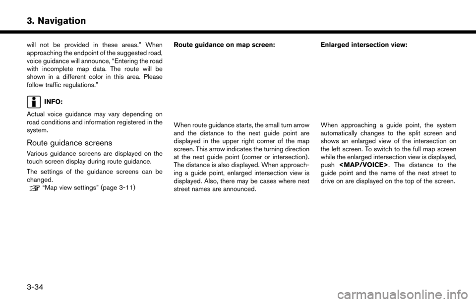
“Map view settings” (page 3-11) Route guidance on map screen:
When route guidance starts, the small turn arrow
and the distance to the next guide point are
displayed in the upper right corner of the map
screen. This arrow indicates the turning direction
at the next guide point (corner or intersection) .
The distance is also displayed. When approach-
ing a guide point, enlarged intersection view is
displayed. Also, there may be cases where next
street names are announced. Enlarged intersection view:When approaching a guide point, the system
automatically changes to the split screen and
shows an enlarged view of the intersection on
the left screen. To switch to the full map screen
while the enlarged intersection view is displayed,
push
Page 95 of 268
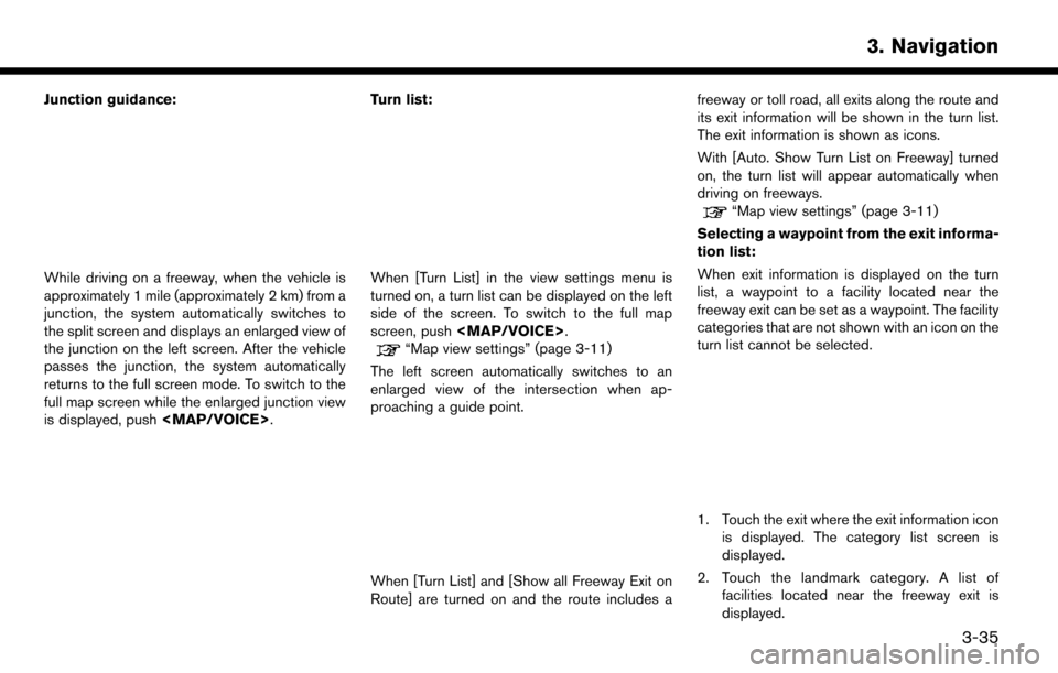
Junction guidance:
While driving on a freeway, when the vehicle is
approximately 1 mile (approximately 2 km) from a
junction, the system automatically switches to
the split screen and displays an enlarged view of
the junction on the left screen. After the vehicle
passes the junction, the system automatically
returns to the full screen mode. To switch to the
full map screen while the enlarged junction view
is displayed, push
Page 96 of 268
INFO:
The facility categories that are not shown
with an icon cannot be selected.
3. Touch the preferred facility for the waypoint.
4. The waypoint is set, and the route search is performed.
“Options before starting the route
guidance” (page 3-28)
5. Touch [Start] to start the route guidance.
ROUTE MENU
WARNING
Always stop the vehicle in a safe location
before modifying the route conditions.
Modifying the route conditions while
driving may cause an accident.
During route guidance, the route conditions can
be modified and the route information can be
confirmed. Set route conditions according to
your personal preference.
Touch [Navi] on the Launch Bar.
Route menu screen is displayed when a destina-
tion is already set.
3-36
3. Navigation