Page 25 of 229

Top Menu
25
Introduction Basic Operation
INFO Menu
This section explains the info menu displayed when you press the INFO key.
The order of display items may differ depending on the model.
In that case, 9)
Fuel/Weather changes to HD Information .
2)3)
4)
5)
6) 1)Menu 1
7)
8)
9)10)11)
12) Menu213)14)
1) Display switch menu
(P21)
Allows you to switch the menu display
type.
2)
Calendar
(P131)
Displays the calendar. Allows you to check
and set special days and anniversaries.
3)
GPS Information
(P143)
Allows you to check the name of the
current location, its latitude/longitude,
and the number of GPS satellites being
received.4)
Trip * (P138)
Allows you to check and set trip
information.
5)
Environment * (P153)
Allows you to check the outside air
temperature, altitude, and air pressure.
6)
Air Conditioner * (P142)
Allows you to check the air conditioner
status.7)
Maintenance * (P154)
Allows you to make settings for
notifi cations when engine oil, oil fi lter, and
other maintenance is due.
8)
Mobile Phone * (P145)
Allows you to make and receive telephone
calls.
9)
Fuel/Weather
(P159)
Allows you to check Fuel prices and
weather information.
10)
User SD
(P136)
Allows you to check the SD card capacity
and available space.
Also allows you to update the map
database
(P137).
11)
more
When there are many items, you can
move forward/back by page. This is not
displayed when there are few items.
12)
Map Reg. Code (P137)
Allows you to check the request code
required for updating the map.
13)
Voice Control Help * (P195)
Allows you to check a list of voice
commands, the usage for voice control,
etc.
14)
Version Info.
(P165)
Allows you to check the program version,
map version, etc.
* This is displayed when your car is equipped with the
equipment.
Page 26 of 229
26 Top Menu
SETTINGS Menu
This section explains the settings menu displayed when you press the SETTINGS key.
6)
Sound Quality Control
may not be displayed depending on the model.
2)1)
3)5)6)
4)
1) Display Off
(P216)
Allows you to switch OFF the screen
display.
2)
Picture Control
(P216)
Allows you to adjust the picture quality.
3)
Vehicle Settings *1 (P216)
Allows you to make settings for vehicle
equipment.4)
System *2
Allows you to make settings for the
Time
(P211), Language (P211), Opening
Setting
(P212), Camera (P152), A/C Cut-
in
(P212), Units (P212), Pairing (P213),
Keyboard Layout
(P215), etc.
5)
Clock Screen
(P221)
Displays the clock.
6)
Sound Quality Control (P207)
Allows you to perform settings related to
sound quality.
*1 This is displayed when your car is equipped with the
equipment.
*2 Depending on the equipment, some of the items in
[System] may not be displayed.
Page 27 of 229

Navigation Functions
27
NAVI Basic Operation
NAVI
This chapter explains navigation function operations.
Basic Operation
Navigation
Functions
What is Navigation?
Navigation is a system that measures the
location of your car and guides you along the
route to the set destination. Your car's location
displayed on the map is measured with the
“GPS” and “Map matching” functions.
GPS(Global Positioning
System)
The system that uses GPS satellites to detect
the location is called “GPS”. The radio signals
from these GPS satellites are received and
the location of one's own car is measured to
within about 30 to 200 meters.
• Measuring your car's location takes about 2
minutes in a location with a good view. The
fi rst time this product is used or it is used
after a long while, it takes about 5 minutes to
measure your car's location.• The GPS satellites are managed by the
Department of Defense of the United States
of America, which sometimes deliberately
reduces the location precision. When that
happens, the location of your car may not be
displayed in the correct location.
Map Matching
“Map matching” is a function that compares
the route tracking data for your car with the
road confi guration in the map data, estimates
the road you are driving on, and displays this
on the map.
CAUTION
• The map displayed for navigation and
the traffi c rule information were prepared
based on various types of information
when the map data was prepared, so
they may differ from the actual roads
and traffi c regulations. Always follow the
actual roads and obey the actual traffi c
regulations.
GPS Antenna
GPS��antenna
The location of your car is measured by
receiving weak radio signals from GPS
satellites with the “GPS antenna”.
ADVICE
If the radio signals from the GPS satellite
are blocked, the location of your car may
not be displayed in the correct location, so
observe the following rules.
• Do not paste a mirror type fi lm or shade
fi lm that contains carbon onto the
windshield.
• Do not place anything on or near the
GPS antenna.
• Do not use a mobile phone, PHS,
computer, etc. near the GPS antenna.
Page 28 of 229

28 Navigation Functions
Map Data
The map data may contain wrong or missing
characters, incorrect locations etc.
Position Measurement
When Accurate Position
Measurement Is Not Possible
Radio signals from GPS satellites cannot be
received in locations such as in tunnels, indoor
parking garages, locations surrounded by high
buildings, mountains or trees, under freeways
and elevated train lines. In such cases, the
position measurement uses autonomous
navigation based on the gyro sensor and
speed sensor, so accurate measurement of
your car's location may become impossible.
Measurement Error
When radio signals cannot be received from
GPS satellites, measurement error occurs
easily and the location of your car may not be
displayed correctly.
If you keep on driving, when it becomes
possible to receive radio signals from GPS
satellites, the error in the current location will
be automatically corrected.Reasons Why the Location of Your
Car Is Not Displayed Correctly
• When a freeway and general road are near
each other
• When driving roads laid out in a grid
• When driving on a mountain road with a
sharp slope
• When turning left or right after having driven
a long while on a straight road
• Immediately after the engine is switched ON
• When driving at slow speed, for example on
a congested road or in a parking lot (Because
some cars do not output a vehicle speed
signal when driving too slow)
• When traveling with chains on the tires
• When the vehicle was turned on a turntable
or the like
• When driving through a fork in the road with
a small angle between the two branches
• After the vehicle has been moved by ferry or
the like
• When driving in a multi-level parking garage
or on a spiral road
• When zig-zagging on a wide road
• When a tire has been replaced with the
emergency spare
• When driving on snow, sand, or other
slippery road
3D Position Measurement
When effective radio signals for which
positional precision can be expected can be
received from four or more GPS satellites, the
3D position of latitude, longitude, and altitude
can be calculated.
“GPS Information”(P143)
2D Position Measurement
When effective radio signals for which
positional precision can be expected can be
received from three or more GPS satellites
but not enough for 3D position measurement,
the altitude is assumed to have remained
the same since the last time it could be
measured and only the 2D of latitude and
longitude can be calculated. In this case, the
positional precision is less than for 3D position
measurement.
“GPS Information” (P143)
Non-measurable Position
When effective radio signals from GPS
satellites for which positional precision can be
expected can not be received, the position is
not measured.
“GPS Information”(P143)
Page 29 of 229

Navigation Functions
29
NAVI Basic Operation
Route Search Methods
• The route displayed in the route guidance
is a reference route to the destination. It
is not necessarily the shortest route. This
route guidance also does not take traffi c
congestion information into account.
• Not all roads are used in route guidance.
• Routes using ferries are set to be less
recommended than normal roads. Therefore,
even when a ferry provides a quicker route
to the destination, a route not using the ferry
may be displayed.
• When a toll road interchange, parking area,
or service area is set as the destination or
as a waypoint, select from an establishment
search or from a freeway simplifi ed map and
set without scrolling the map.
• Sometimes, the route is not the same as the
one prepared previously even though the
same locations were set as the destination
and waypoints.
• Sometimes routes are displayed that include
pedestrian ways, stairs, etc. that are not
passable by vehicle.
• If there is no road to the destination or only
narrow roads, a route may be displayed
that goes to some place apart from the
destination.
• Because searches are carried out passing
alongside establishments, depending on the
road confi guration, roundabout routes may
be displayed.
• Sometimes routes are searched that take
traffi c rule information into account.
• Sometimes, some temporary rules are not
taken into account or the time for which
they are applied differs from when they are
actually in effect.
Route Guidance
• When your car is driving on the searched
route, this displays the distance until the
destination or the next waypoint.
• When your car is driving off the searched
route, this displays the distance from the
point where you left the route until the
destination or the next waypoint.
• The display of the estimated time of arrival
at the destination is calculated based on the
remaining time data in the map data and
learning trip information.
• Sometimes even though you need to turn
at a junction, the junction name is not in the
guidance and the junction is not covered in
the audio guidance.
• Sometimes left and right turn guidance
differs from the actual road confi guration.
• When you go off the route, for example by
turning one junction too early, sometimes the
audio guidance continues for the route you
had been on.
• Sometimes the distance in the guidance is
slightly too high or too low.
Precautions for operating the
navigation
• During route guidance, always obey the
actual traffi c regulations. Failure to do so
may cause a traffi c accident.
• The route is searched using the map data on
the map card. Sometimes it may differ from
actual restrictions for construction, one-way
rules, and other traffi c rules. Always obey
the actual traffi c regulations.
• Traffi c rules that depend on the time of
day refl ect the time at which the route was
searched. When driving the route, always
obey the actual traffi c regulations.
• The distance your car has traveled is
measured with the speed sensor (and this
speed is proportional to the rotation rate of
the tires).When the tires are new, if you have
non-standard tires, or if the tire air pressure
is not correct, error inputs the distance
measurement more easily and the location
of your car may not be displayed correctly.
• The route is a reference route to around the
destination. It is not the shortest route or the
route most free of traffi c congestion.
• While you are driving, the amount of road
information displayed is restricted and some
roads may not be displayed.(For example,
narrow streets)
• If the distance to the destination is extremely
short or extremely long, route search may be
impossible.
• Even if you travel off the route, the route is
automatically recalculated.
• The estimated time of arrival varies with the
road conditions and how you drive.
Page 30 of 229

30 Navigation Screen
Navigation Screen
This section explains the navigation map screen and the display contents for the menu
screens.
Map Display Contents
The map screens include the current location screen and scroll screens (P31).
Current Location Screen
This section explains the contents displayed on the current location screen, which is displayed
when you press the MAP key.
3)
4) 1)6) 5)
8)
7)
2)
9)
10)
1) Route guidance mark
The road you are to drive is indicated by
an arrow.
With the [Screen] “Searched Root”, you
can select [Arrow] or [Line].
→“Navi Settings”(P196)
2) Car's location mark
The arrow shows the location of your car
and the direction of the arrow shows the
direction you are traveling in.
3) Junction guidance icon
Shows the distance until the next junction
to turn and which way to turn. Touching
this displays the junction guidance map.
→“Check the Next Junction to Turn”(P58)
4) ▲
(P33)
Displays a sub-menu.
5) Icons
(P32)
Displays the current telephone and audio
status.
6) Clock
Displays the current time using 12- or 24-
hour time.
7)
RTT
Displays traffi c congestion information and
traffi c rule information etc. Touching RTT
symbol allows you to check the detailed
information.
→ “Checking the RTT Traffi c Messages” (P79)
8) Direction icon
Touching this displays the map switching
screen.
→“Select the Map Screen”(P34)
9) Scale icon
Shows the scale of the displayed map.
Touching this changes the scale.
→“Switch the Scale”(P40)
10) Destination/waypoint information
Shows the time, direction, and distance
to the destination or waypoint. Each time
you touch this, the display switches to the
estimated time of arrival, time remaining,
and local time. The time and distance at
this time are the expected time of arrival,
time remaining, or local time and distance
to the destination or waypoint from a
location off the route.
ADVICE
• The menu items vary with the navigation
settings and travel status. Some items
may not be displayed.
• To make the explanation clearer, the
navigation images in this manual leave
out some landmarks.
Page 31 of 229
.")
Navigation Screen
31
NAVI Basic Operation
Scroll Screens
This section explains the contents displayed on the scroll screens displayed when the map is
scrolled or after a search is performed (P40).
6)
Adjust may change to Tuning depending on the model.
2)
3)
4) 1)
6) 5)
7)
9)8)
1) City name
If there is a city name for the cursor
position, this city name is displayed.
2)
mark
Shows the starting point with the mark.
3)
mark
The set destination
(P47) is shown with
the
mark.
4)
mark
The Cursor mark is displayed at the center
point of the location scrolled to.5)
Set
Displays the scroll menu
(P32).
Allows you to set the destination,
waypoints, and address book.
6)
Adjust
The
mark position can be fi ne tuned.
→“Scroll Fine Adjustment”(P41)
7) mark
The set waypoints
(P61) are shown with
the
mark.
Up to 5 waypoints can be set. They are
shown with
, , , , in the
order in which they are passed.
8) POI icons
Trademarks, sight-seeing areas, etc. are
shown with these marks.
9)
Back
Returns to the previous screen.
ADVICE
• The display of 7) POI icons can be
removed from the map screen by setting
[Hide All] for [Screen] “POI icons”.
→“Navi Settings”(P196)
• You can select which 7) POI icon types to
display and which not to display.
→“POI Icons on Map”(P201)
Page 32 of 229
.
Displayed when connected to
Bluetooth.
→“Bluetooth Setting”(P213)
Displ")
32 Navigation Screen
Individual Icons
This section explains the icons displayed on
the current location screen (P30).
Displayed when connected to
Bluetooth.
→“Bluetooth Setting”(P213)
Displays the signal strength
and whether or not the phone is
roaming.
Displayed when the phone is
used.
Redisplays the phone operation
panel
(P150).
Whether or not to display can be
selected with [Screen] “Mobile
Phone Icon”.
→“Navi Settings”(P196)
AV icon
Displays the status of the audio
source currently being used.
For details, see
“AV Icons”(P83).
Whether or not to display can
be selected with [Screen] “Other
Indicator Icons”.
→“Navi Settings”(P196)
NOTE
• The audio screen currently being played
can be displayed by touching the AV icon
depending on the model.
Display the Destination Menu
You can set the destination and erase routes
from this menu screen.
The
DEST key may change to the key
depending on the model.
1Press the DEST key.
▼
This displays the destination menu.
Display the Scroll Menu
You can set the location scrolled (P40) to as the destination or set it in the address
book.
ADVICE
• You can also display the scroll menu from
the map screen displayed with search
results by touching [Adjust], and then
[Set].
1On the scroll screen, touch
Set .
▼
The scroll menu is displayed.
 1
1 2
2 3
3 4
4 5
5 6
6 7
7 8
8 9
9 10
10 11
11 12
12 13
13 14
14 15
15 16
16 17
17 18
18 19
19 20
20 21
21 22
22 23
23 24
24 25
25 26
26 27
27 28
28 29
29 30
30 31
31 32
32 33
33 34
34 35
35 36
36 37
37 38
38 39
39 40
40 41
41 42
42 43
43 44
44 45
45 46
46 47
47 48
48 49
49 50
50 51
51 52
52 53
53 54
54 55
55 56
56 57
57 58
58 59
59 60
60 61
61 62
62 63
63 64
64 65
65 66
66 67
67 68
68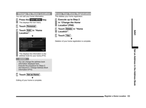 69
69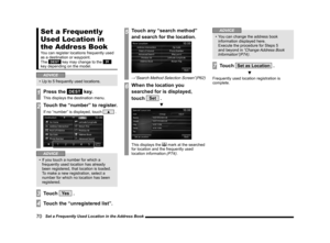 70
70 71
71 72
72 73
73 74
74 75
75 76
76 77
77 78
78 79
79 80
80 81
81 82
82 83
83 84
84 85
85 86
86 87
87 88
88 89
89 90
90 91
91 92
92 93
93 94
94 95
95 96
96 97
97 98
98 99
99 100
100 101
101 102
102 103
103 104
104 105
105 106
106 107
107 108
108 109
109 110
110 111
111 112
112 113
113 114
114 115
115 116
116 117
117 118
118 119
119 120
120 121
121 122
122 123
123 124
124 125
125 126
126 127
127 128
128 129
129 130
130 131
131 132
132 133
133 134
134 135
135 136
136 137
137 138
138 139
139 140
140 141
141 142
142 143
143 144
144 145
145 146
146 147
147 148
148 149
149 150
150 151
151 152
152 153
153 154
154 155
155 156
156 157
157 158
158 159
159 160
160 161
161 162
162 163
163 164
164 165
165 166
166 167
167 168
168 169
169 170
170 171
171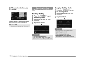 172
172 173
173 174
174 175
175 176
176 177
177 178
178 179
179 180
180 181
181 182
182 183
183 184
184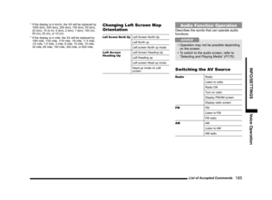 185
185 186
186 187
187 188
188 189
189 190
190 191
191 192
192 193
193 194
194 195
195 196
196 197
197 198
198 199
199 200
200 201
201 202
202 203
203 204
204 205
205 206
206 207
207 208
208 209
209 210
210 211
211 212
212 213
213 214
214 215
215 216
216 217
217 218
218 219
219 220
220 221
221 222
222 223
223 224
224 225
225 226
226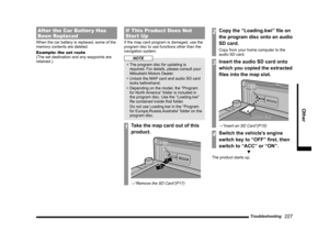 227
227 228
228
Sound Quality Control
may not be displayed depending on the model.
2)1)
3)5)6)
4)
1")