Page 102 of 252
101
Map Menu
Guidance Menu
HENTER button (on map)
Guidance Menu
Directions
Display a list of the guidance points
on your route for your confirmation.
1.Rotate
i
to select a guidance
point from the list. Press
u
.
The system displays a map of the guidance point.
2.Press
u
to select
RETURN
or press
the CANCEL (BACK) button to return to the previous screen.
■Directions
1DirectionsGuidance points with exit information are indicated by a (freeway exit information) icon. Move
y
to select
Exit Info
to display the
exit information. 2Freeway Exit Information
P. 102
The route guidance inform
ation is automatically
deleted when you reac
h your destination.
QRG
Navigation
Page 104 of 252
103
Map Menu
Guidance Menu
HENTER button (on map)
Guidance Menu
Guidance Mode
Select the display mode during route guidan
ce: single-screen mode (default) or split-
screen mode.
Rotate
i
to select an option.
The following options are available: •Single Screen:
Displays the map and guidance screens on separate screens.
■Guidance Mode
1Guidance ModeThe guidance mode can al
so be selected from
the System Setup menu. 2Routing & Guidance
P. 48
Map screen
Press the MAP/GUIDE button
Guidance screen
Continued
QRG
Navigation
Press
u
.
Page 109 of 252
108
Map Menu
Map Information
Navigation
HENTER button (on map)
Map Information
Select the map orientation.
Rotate
i
to select
North-up
or
Heading-up
. Press
u
.
The system changes the map orientation and displays the
The following options are available: •North-up
: Displays the map with
North always pointing up.
•Heading-up
: Displays the map so that the direction you are traveling is always
pointing up.■Map Orientation
1Map Orientationd
“Display Heading-up”
(from map screen),
d
“Display North-up”
(from map screen)
The red arrow in the symbol always points North. On scales greater than
1 mile, North-up mode is
always used.
QRG
map screen.
Page 110 of 252

109
Map Menu
Map Information
HENTER button (on map)
Map Information
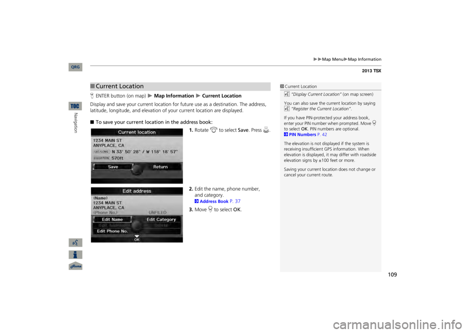
Current Location
Display and save your current location for fu
ture use as a destination. The address,
latitude, longitude, and elevation of your current location are displayed. ■To save your current loca
tion in the address book:
1.Rotate
i
to select
Save
. Press
u
.
2.Edit the name, phone number, 2Address Book
P. 37
3.Move
r to select
OK
.
■Current Location
1Current Locationd
“Display Current Location”
(on map screen)
You can also save the current location by saying d
“Register the Current Location”
.
If you have PIN-protec
ted your address book,
enter your PIN number when prompted. Move
r
to select
OK
. PIN numbers are optional.
2PIN Numbers
P. 42
The elevation is not displayed if the system is receiving insufficient GPS information. When elevation is displayed, it
may differ with roadside
elevation signs by ±100 feet or more. Saving your current loca
tion does not change or
cancel your current route.
QRG
Navigation
and category.
Page 111 of 252
110
Map Menu
Map Information
Navigation
HENTER button (on map)
Map Information
Map Legend
See an overview of the map lines, areas, rout
es, traffic information, navigation icons,
and weather icons.
Rotate to
i
select an item.
The system displays the map
legend.
■Map Legend
1Map LegendA visual guide helps you see the map legend. 2Map Screen Legend
P. 10
2AcuraLink Real-Time Traffic™
P. 15
2AcuraLink Real-Time Weather™
P. 15
QRG
Page 117 of 252
116
Map Menu
Weather Information
Navigation
HENTER button (on map)
Weather Info.
Warning List So
rted by Distance
View a list of all weather
warnings for a given locati
on or route (U.S. only).
1.Rotate
i
to select a warning.
Press
u
.
Move
w
or
y
to select
All
US
, Within 500mi
, or
On
Route
to specify the warnings
to display.
The system displays the detailed information.
2.Press u
to listen to the weather
warning.
■Warning List
1Warning ListA warning icon in the list indicates that your vehicle is in the warning area or that the calculated route runs through the area. The “On Route” tab is available only when you are following route guidance. You can also say
d
“Read List”
to listen to the
weather warning information.
QRG
Page 118 of 252
117
Map Menu
Weather Information
HENTER button (on map)
Weather Info.
Warning Map
View a color-coded weather warning map.
Each color corresponds to a different
type of warning.
1.Scroll the map to position the cursor over a colored area, adjusting the map scale as necessary. Press
u
.
The system displays the detailed information.
2.
■Warning Map
1Warning MapYou can change the map scale to 50, 150, or 350 miles. Moving the cursor does not
display the detailed
information.You can also say
d
“Read List”
to listen to the
weather warning information.A visual guide helps y
ou see a weather warning
map. 2AcuraLink Real-Time Weather™
P. 15
QRG
Navigation
Press u
to listen to the weather
warning.
Page 119 of 252
118
Map Menu
Weather Information
Navigation
HENTER button (on map)
Weather Info.
Radar Map
View a weather radar image map di
splaying rain and snow systems.
Scroll the map to view weather information, adjust
ing the map scale
as necessary.
■Radar Map
1Radar MapYou can change the map scale to 50, 150, or 350 miles. Moving the cursor does not
display the detailed
information.A visual guide helps y
ou see a weather radar
image map. 2AcuraLink Real-Time Weather™
P. 15
QRG