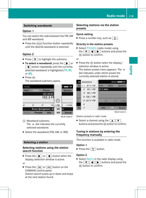
Page 89 of 214

Disp
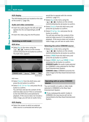
laying andc hangi nganavoi ded
area X
Select anentry inthe listusi ng the
9: buttons.
X Select Option s usi
ng the ; button and
press the9button toconfirm.
X Select Displa y/Change and
press the
9 button toconfirm.
The area tobe avoi ded isindi cated inthe
map.
X To chang ethe posi tion ofthe area: press
the =;9 or; button.
The area ismoved onthe map.
X To chang ethe size ofthe area: press the
U orT button.
The area isenla rged orredu ced.
X To confirm thechang e:press the9
button.
The lista ppears andthechang eis ent ered.
Deleting asetarea X
Sele ctan ent ryinthelist usin gth e
9: buttons.
X Sele ctOpt ions usin
gth e; buttonand
pres sth e9 butt ontocon firm.
X Sele ctDel ete and
pres sth e9 butt onto
con firm.
Aq uery appear sask ing whet hertheen try
sho uld bedelet ed.
X Se lec tYes or
No .
If you selectYes ,
th een try is delet ed.
If you selectNo ,
th epro cess will be
can celed. "R
ecor drou te" funct ion
Swit chingth efu nct ion on/of f X
To swit chon nav igationmod e:pre ssthe
Ø function button.
X To show themen u:pre ssthe9 button. X
Se lec tNav i in
themain function bar usin g
th e9=; buttons and pressthe
9 buttonto confirm .
X Se lec tSav eOff -roadRoute and
press
th e9 buttonto confirm . Off
-road routemen u
X Se lec tSav eOff -roadRoute again
and
pre ssthe9 buttonto confirm .
De pen dingon thepre vious state ,swit ch
th eopt ion onO oroff ª.
X To exit themen u:pre ssthe=
or ; button.
Disp laying mem oryusage When
themem oryis90 %full, youseea
mes sage tothis eff ect.You willalso seea
mes sage when themem oryisco mple tely full.
X To confi rmthemes sage:pre ssthe9
but ton.
i Inord erto be able tocontinue usingth e
"Reco rdrout e"fun ction ,you should delete
the route memory afterwards.
X To switch onnavigation mode:pressthe
Ø functionbutton .
X To show themenu: pressthe9button .
X Select Navi in
the main functionbar using
the 9=; buttonsand press the
9 button toconf irm.
X Select SaveOff-road Route and
press
the 9button toconf irm. Additional
settings
87Navigation system Z
Page 90 of 214

X
Sel ect Off -road Rou
te Mem
ory and
press
the 9button toconfi rm. Off-ro
adrou tememo rymenu
X Sel ect Off -road Rou
te Mem
ory Use
d and
pre ssthe 9button toconfi rm.
Ab arsho wsthemem oryusage asa
perc entag e.
X To close thedis pla y:pres sth eß
fun ction button.
i When themem oryisco mple tely full, you
can notselec tth eOff -roadRoute Mem
ory men
uite m.
Deleti ngtherou temem ory X
To swit chon nav igat ionmod e:pres sth e
Ø function button.
X To show themen u:pres sth e9 button.
X Sel ect Navi in
themain function bar usin g
th e9=; buttons and pres sth e
9 buttonto confirm .
X Sel ect SaveOff -roadRoute and
pres s
th e9 buttonto confirm .
X Sel ect Off -road Rou
te Mem
ory and
pres s
th e9 buttonto confirm .
X Sel ect Delete Off-roadRouteMemory and
pres sth e9 buttonto confirm .
Aq uery appear sask ing whet herthe
mem oryshould bedelet ed.
X Se lec tYes or
No .
If you selectYes ,
th emem oryisdelet ed. If
you selectNo ,
th epro ces swill be
can celed. Free
way information
When drivingonfreeways, youcan have the
ne ares tgas statio ns,res tareas, etc.,aswel l
as you rcurr entd istanc efrom them, shown
on the right-hand sideofthe disp lay.
X To swi tch onnavig ation mode: pressthe
Ø function button.
X To show themenu: pressthe9button.
X Select Navi in
the main function barusing
the 9=; buttonsandpress the
9 button toconfirm.
X Select Highway Information and
press
the 9button toconfirm.
Dependi ngon the previ ousstate, switch
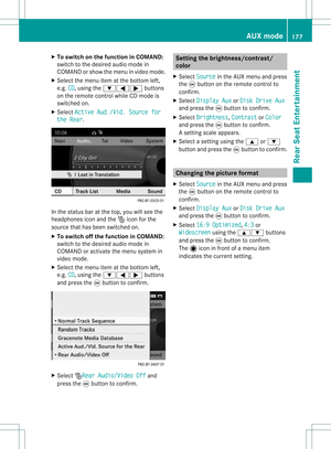
the option onO oroff ª. Example
displaywith function active
: Icons forfreew ayservice facilities
; Name offreew ayservice
= Distance fromcurrent vehicleposi tion
i Ifthe digitalmap does notsupplyany
data ,only astyli zed road witho utfreew ay
informati onisvisib leon the right-hand side
of the disp lay. 88
Additio
nalsetting sNavigatio nsystem
Page 91 of 214

Comp
assfunct ion
You canseethecur ren tvehicle position and
direct ionoftravel inthe compass view.
X To switch onnavigat ionmode: pressthe
Ø function button .
X To show themenu: pressthe9button .
X Select Positio n in
the navigation menu
bar using the:=; buttonsand
press the9button tocon firm.
X Select Compass and
press the9button to
con firm.
Depen dingonthe previous state,switch
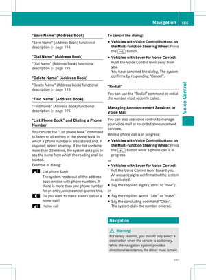
the option onO oroff ª. Ex
ample display: compass
: Current directionoftravel
; Current heightaboveaverage sealevel
(rounded tothe nearest 50m)
= Current vehicleposition :longitude
coordinat es
? Number ofGPS satellites currentlybeing
used
A Current vehicleposition: latitude
coordinat es
B Currently setsteerin gangle ofthe front
wheels
i Todisplay current height;,thesystem
must beable toreceive atleast four
satellites. Steeringangle Bcan bea
maximum of35° inboth direction s. Upda
tingthedigital map
Introdu ction The
digital mapsgenerated bythe map
software becomeoutdated inthe same way
as conv ention alroad maps. Optimal route
guidance canonly beprovided bythe
navigation systeminconj unct ionwith the
most up-to- datemapsoftware.
Infor mation aboutnewversions ofthe digital
map canbeobtained fromanauthorized
Mercedes-B enzCenter. Youcanhave your
digital mapupdated therewithaDVD ,or you
can update ityourself.
i The update process cantake along time
(over anhour), depending onthe size ofthe
map software. Duringthistime, youwill
only beable toswitch onradio mode and
to accept incomin gcalls. Theupdate willbe
completed morequickly ifthe vehicle is
station ary.
If you carry outtheupdate withtheengine
switched offand thestart erbattery has
insufficient power,COMAND may
automatically switchoffduring theprocess
in order toprotec tthe battery. Ifthis
occurs, restarttheupdate withtheengine
runnin g. G
War
ning!
Never runtheengine inan enclosed space.
The exhaust fumescontainpoisonous carbon
monox ide.Inhaling exhaustfumesis
hazardous toyour health andcanlead toloss
of consc iousness anddeath.
Upda teprocess X
Insert theDVD (Ypage 129).
The update begins. COMAND checks
whether thedigital maponthe DVD is
compatible withthenavigation systemand
system software.
If this isthe case andtheDVD 'smap data
has notalready beeninstalled, the
COMAND startsupdating thedigital map. Additional
settings
89Navigation system Z
Page 92 of 214

If
the map data hasalready been install ed,
the disp layshows version dataanda
messag eto this effect.
X To con firm themessage :press the9
button.
X Eject theDVD.
Whil ethe update isrunning, youwillsee a
messag eto this effect andaprogress bar.The
naviga tionsystem isnot opera tional untilthe
upd ate iscomplete.
i You cannot ejecttheDVD duringthe
upd ate. Ifyou switch offCOMAND during
the update, theupdate isinterrupted. It
then continues fromwhere itwas
interrupted whenthesystem isrestarted.
COMAND mayprompt youtochange theDVD
duri ngthe update.
X Press theV load/eject button.
X Take theDVD outofthe slot.
X Insert thereque stedDVD.
Once theupdate has been successfu lly
completed, youwillsee amessag eto this
effect.
X To con firm themessage :press the9
button.
X Take theDVD outofthe slot.
The update iscomplete.
If the upd ateisnot successfu llycompleted,
you willsee amessag ethat themap update
is not possi ble.
X To con firm themessage :press the9
button.
X Take theDVD outofthe slot. 90
Addition
alsettingsNavigation system
Page 93 of 214

Problems
withthenavigation system Problem Possible
causes/co nsequences andM Solutions
COMAND
isunable to
cont inue route
guida nceafter the
journey hasbeen
interr upted. Route
guidanceiscanceled ifyou interr uptthejourney formore
than twohours.
"Interr upting thejourney" referstostopping thevehicle and
switching offCOMAND. "Continuing routeguidance"refers to
switching COMAND backonand driving on.
X Continue routeguidance(Ypage 68).
COMAND determines thevehicle's position.Depending onthe
driving situation, thismay take some time.
Route guidancemay berestric tedduring thedeterminat ionof
the vehicle's position.
When positioning iscomplete, routeguidanceisresumed with
navigation announcementsandroute guidancedisplay s. Problem Possible
causes/co nsequences andM Solutions
COMAND
isunable to
determine thevehicle's
position. COMAND
hastoredetermine theposition ofthe vehicle ifthe
vehicle hasbeen transport ed(e.g. byferry, bymotorail orafter
towing).
X Start thevehicle andpullaway .
COMAND determines thevehicle's position.Depending onthe
driving situation, thismay take some time.
Route guidancemay berestric tedduring thedeterminat ionof
the vehicle's position.
When positioning iscomplete, routeguidanceisresumed with
navigation announcementsandroute guidancedisplay s. Problems
withthenavigation system
91Navigation system Z
Page 94 of 214

Problem Possible
causes/co nsequences andM Solutions
The
Navigation Unavailable message
appea rs. COMAND
hasanintegrated harddiskonwhich thedigital mapis
stored.
To protect thehard diskfrom damage, COMAND switchesitoff at
very high temperatures. Thenavigation systemwillthen be
temporarily unavailable.
X Let the vehicle andCOMAND cooldown.
X To hide themessage: switchCOMAND offand then onagain. If
an area ofthe hard dischasamalfunction ,COMAND canno
longer access themap data inthis area, forexample when
calculating aroute.
X To hide themessage: switchCOMAND offand then onagain.
The navigation systemwillbeoperational againuntilithas to
access thefaulty areaofthe hard diskonce more. Themessage
will then reappear.
X Consult anauthorized Mercedes-B enzCenter. Problem Possible
causes/co nsequences andM Solutions
You
willsee amessage
informin gyou that the
DVD containing the
digital mapis
incompatible withthe
system software. The
DVD containing thedigital mapcannot beused forthe update.
X To confirm themessage: pressthe9button.
X Ejec tthe DVD .
X Have thesystem software updatedatan authorized Mercedes-
Benz Center. Problem Possible
causes/co nsequences andM Solutions
The
map software
update hasfailed. The
DVD isdirty orscratc hed.
X Clea nthe DVD .
X Restart theupdate. There
isoverheating duetoexcessive temperatures inthe vehicle
interior.
X Wait untilthevehicle interior hascooled down.
X Restart theupdate. COMAND's
integralharddiskisfaulty.
X Consult anauthorized Mercedes-B enzCenter. 92
Problems
withthenavigation systemNavigationsystem
Page 95 of 214
Vehi
cle equi pmen t<0023002300230023002300230023002300230023002300230023002300230023
00230023002300230023002300230023002300230023002300230023> 94
General notes<0023002300230023002300230023002300230023002300230023002300230023
0023002300230023002300230023002300230023002300230023002300230023
002300230023002300230023> 94
Telephony viathe Bluet ooth®
inter-
face ........ .......... .................. .................. . 95
Reception andtransm ission volume .99
Telephone operation........ .......... ....... 100
Using thephone book<0023002300230023002300230023002300230023002300230023002300230023
002300230023002300230023> 102
Using calllists .................. ................. 107
Using theaddress book <0023002300230023002300230023002300230023002300230023002300230023
002300230023> 109
Opera tingthetelephone usingthe
mult ifunction steeringwheel.......... 115 93Telephone
Page 96 of 214

Vehi
cle equi pmen t
i TheseOpe rating Instru ctionsdescri beall
sta nda rdand optio nal equipme ntava ilab le
for your veh icleat the time ofpurcha se.
Pl ea se note thatyour vehicle maynotbe
equipped withallfeatures described. General
notes Introdu
ction
The telephone function,inconj unct ionwith a
Bluetooth ®
-capable mobilephone, offers
Bluetooth ®
inter face telephony.
Using theBluetooth ®
inter face andasuitable
mobile phone, youcan receive vCards.
For more inform ationonsuitable mobile
phones andonconn ectin gaBluetooth ®
-
capable mobilephonetoCOMAND, visit
htt p://www.mbusa- mobile.comorcall
the Mercedes-B enzCustomer Assistance
Center under
1-8 00-FOR-ME RCedes(1-800- 367-6372 )
(US) orCustomer Relationsunder
1-8 00-387- 0100 (Canada) . Import
antsafety notes G
War
ning
A driver's attentiontothe road must alway s
be his/her primary focuswhendriving. For
your safety andthesafety ofothers, we
recommen dthat youpull over toasafe
location andstop before placing ortakin ga
telephone call.Ifyou choose touse themobile
phone whiledriving, pleaseusethehandsfree
device andonly usethemobile phonewhen
weather, road,andtraffic conditionspermit.
Some jurisdiction sprohibit thedriver from
using acellular mobilephonewhiledriving a
vehicle.
Bear inmind thatataspeed ofjust 30mph
(approximately 50km/ h),your vehicle is coverin
gadistance of44 feet (approximately
14 m)every second. G
War
ning
You andothers maydamage yourhealth due
to excessive electromagneticradiation. By
using anexter nalanten na,the possible health
risks ofelectrom agneticfields,whichare
under discussion amongthescient ific
communit y,should belargely prevent ed. Calls
disconnec tedwhile thevehicle
is in motion
Ac allmay bedisc onnected if:
R there isins ufficie ntnetwo rkcover age in
cer tain areas .
R you mov efrom onetrans mitter/ rec eive r
area (cell)int oano ther and nochann elsare
fr ee.
R you useaSI M car dwhic his no tcompatible
with thenetwork available.
R when usingamobile phonewith
"Twincard", thesecond SIMcard is
registered onthe network atthe same time. Operat
ingoptions
You canoperate thetelephone byusing:
R the = and; button orthe 9button
on COMAND
R the 6 or~ button andthenumber
keypad onCOMAND
R using the6 or~ button onthe
multifunct ionsteerin gwheel
R voice comman dsvia the Voice Control
System
Unless statedotherwise, thedescription sand
illustrations inthis section refertoCOMAND. 94
General
notesTelephone