Page 49 of 94
48
RoutingAddress
Book
Navigation Set UP
Navigation Set Up
This function allows you to correct any error in the position or direction of your vehicle display.
Before Steps select
Adjusting Current Position and Direction
select
Open the [Calibrate Position] screen
Move to the correct position and select .
Use
or to adjust the direction in which you are
heading, and select .
Distance
This function automatically corrects any error in the display of the current
position that might occur after tire replacement.
select
You will have to drive about 6 miles (10 km) before distance correction is complete.
Set Cloc
The current
a GPS sate
select
Open th
e
Map Vers
The map an
select
Map and so
Calibration
MENU
�%�:�����A�'�#���D�Q�Q�M�����2�C�I�G�����������6�J�W�T�U�F�C�[�����/�C�T�E�J���������������������������������2�/
Page 50 of 94
49
Navigation Set UP
select
.
h you are
urrent
omplete.
Set Clock
The current time is set using this function. Since time notification is \
provided by
a GPS satellite.
select
Open the [SET CLOCK] screen
Select if you prefer 24-hour display;
for 12-hour display.
Select to move the setting ahead by one hour,
and similarly, select to move it back by one
hour.
How to exit .
Map Version
The map and software version numbers can be confirmed using this function.
select
Map and software versions are now displayed.
�%�:�����A�'�#���D�Q�Q�M�����2�C�I�G�����������6�J�W�T�U�F�C�[�����/�C�T�E�J���������������������������������2�/
Page 51 of 94
![MAZDA MODEL CX-7 2007 Navigation Manual (in English) 50
RoutingAddress
Book
Navigation Set UP
Navigation Set Up
This function replaces all the settings in the mobile navigation system with the initial default
settings.
[Default List]
Restore System Def](/manual-img/28/13911/w960_13911-50.png "MAZDA MODEL CX-7 2007 Navigation Manual (in English) 50
RoutingAddress
Book
Navigation Set UP
Navigation Set Up
This function replaces all the settings in the mobile navigation system with the initial default
settings.
[Default List]
Restore System Def")
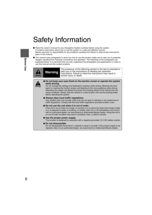
50
RoutingAddress
Book
Navigation Set UP
Navigation Set Up
This function replaces all the settings in the mobile navigation system with the initial default
settings.
[Default List]
Restore System Defaults
Before Steps
select
select
MENU
Open the [SYSTEM DEFAULTS] screen
Select .
If you execute Restore System Defaults, all of your stored setting data will be deleted.
ItemInitial condition
Menu names
Map Orientation North up
Map display mode Single-screen display
Map Display scale/Map scale for Dual-screen is not object of backup.Single-screen: 10,000 map (1/16 mi)Display guidance language English
Quick-POI map display All Off
Quick-POI Selection A : Gas station
B : ATM
C : Police Station
D : Grocery store
E : All Restaurant
F : Hotel
Search Area US9 (including Washington DC)
Map Color 1
Day/Night/Auto Setting Auto
Distance Units (Miles/KM) (Global setting) Miles
Volume Presets 4
Time display change (12h/24h)24h
Keyboard layout ABC
Arrival Time Time
Navigation Setup (Clock) Off
Navigation Setup (Beep) On
Map Configuration
Freeway Infor m ation O ff
Guidance Screen ON
Map screen Single
Turn Guidance Screen Turn List
�%�:�����A�'�#���D�Q�Q�M�����2�C�I�G�����������6�J�W�T�U�F�C�[�����/�C�T�E�J���������������������������������2�/
Page 52 of 94
51
Navigation Set UP
Navigation Set Up
You can change the language of the menu and the voice guidance.
Before Steps
select
select
Language
MENU
Open the [LANGUAGE] screen
Select your preferred language from the list.
�%�:�����A�'�#���D�Q�Q�M�����2�C�I�G�����������6�J�W�T�U�F�C�[�����/�C�T�E�J���������������������������������2�/
Page 53 of 94
![MAZDA MODEL CX-7 2007 Navigation Manual (in English) 52
RoutingAddress
Book
Navigation Set UP
Navigation Set Up
Before Steps
select
select
Map Configuration
MENU
Open the
[MAP
CONFIGURATION]
screen
nMap Screen
Select single or dual map dis](/manual-img/28/13911/w960_13911-52.png "MAZDA MODEL CX-7 2007 Navigation Manual (in English) 52
RoutingAddress
Book
Navigation Set UP
Navigation Set Up
Before Steps
select
select
Map Configuration
MENU
Open the
[MAP
CONFIGURATION]
screen
nMap Screen
Select single or dual map dis")
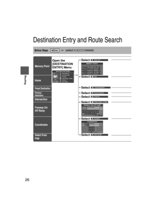
52
RoutingAddress
Book
Navigation Set UP
Navigation Set Up
Before Steps
select
select
Map Configuration
MENU
Open the
[MAP
CONFIGURATION]
screen
nMap Screen
Select single or dual map display.
nTurn Guidance
Enlarged Junction Diagram
Before a fork in the road , an enlarged diagram of the junction automatically
appears in a second screen.This is to make route guidance even clearer.
Turn List
While using route guidance, the
directions for the next junction where
you have to turn are shown as Turn
List.
Turn Arrow
While using route guidance, the
directions for the next junction where
you have to turn are shown as Turn
Arrow.
nJunction Detail
Select whether the Enlarged Junction diagram screen is
displayed automatically.
nFreeway Information
Allows selection of whether the guidance screen is to be
displayed while driving on a freeway.
Single map Dual map
During route guidance, an enlarged
diagram of an approaching fork or junction
appears. When you drive past the junction,
the enlarged diagram disappears.During route guidance, an enlarged diagram of
the freeway automatically appears in a second
screen as you approach a fork on the freeway.
This is to make route guidance even clearer.
�%�:�����A�'�#���D�Q�Q�M�����2�C�I�G�����������6�J�W�T�U�F�C�[�����/�C�T�E�J���������������������������������2�/
Page 54 of 94
 53
If necessary
Precautions/System Performance
Voice guidance has the following functions:
nIntersection guidance
lThe system voice announces the distance to an upcoming turn and the turning direction")
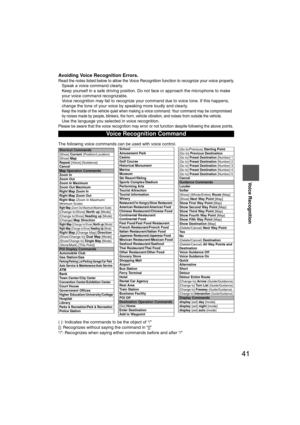
53
If necessary
Precautions/System Performance
Voice guidance has the following functions:
nIntersection guidance
lThe system voice announces the distance to an upcoming turn and the turning direction.
This guidance function is automatic. Therefore, you do not have to set it, and it cannot be
disabled.
l The system vocally announces the distance to an upcoming highway branching point or
junction.
Voice Guidance
l The navigation system is just a support system for the driver. The driver should
always pay attention to the traffic situation to safely make decisions. You may
be unable at times to arrive at your destination due to out-of-date information
on a map disc. You should be especially careful when selecting an urgent
destination such as a hospital or a police station.
l Your route may sometimes include roads that are not open to vehicles or are
closed due to traffic regulations. Please comply with the local traffic
regulations.
l Do not change the settings and destination locations while driving. Minimize
the time spent viewing the monitor screen and listening to the voice guidance
while driving. Operating the system will distract the driver from looking ahead
of the vehicle and may cause an accident. Always stop the vehicle in a safe
location and use the parking brake before operating the system.
When two intersections are close together, the
voice guidance may be late. When two roundabouts are close together, the
voice guidance for the second may be late.
Warnings
Second branching pointFirst branching point150m
100m
Route
In 700m left turn. Left turn ahead,
then right turn.
Roundabout.
Take the second
exit.
�%�:�����A�'�#���D�Q�Q�M�����2�C�I�G�����������6�J�W�T�U�F�C�[�����/�C�T�E�J���������������������������������2�/
Page 55 of 94
 54
RoutingAddress
Book
If necessary
GPS is a position detecting system utilizing the signals
from GPS satellites deployed by the U.S. Department of
Defense. The Mobile Navigation System uses input f")
54
RoutingAddress
Book
If necessary
GPS is a position detecting system utilizing the signals
from GPS satellites deployed by the U.S. Department of
Defense. The Mobile Navigation System uses input from
three or more satellites and calculates the vehicle position
based on the principle of triangulation.
The positioning accuracy of the system corresponds to the
error display of the GPS which is from about 30 to 200 meters.
l If you are using the system for the first time, or if you have not used it for some time, it takes
about 5 minutes (or about 2 minutes in open areas) to calculate your vehicle’s position.
nGPS signal reception is poor in the following places
lThe GPS satellites are controlled by the U.S. Defense Department, which may intentionally
lower positioning accuracy. In such cases, there may be vehicle position deviations.
l There may be vehicle position deviations for some time until GPS signals are received after
turning on the ignition.
This function compares your vehicle’s tracking data with the road data on the map
disc, applies dead reckoning to determine the road you are driving on, and displays
your vehicle on that road on the map.
l Intelligent map matching addresses the following problems to achieve high accuracy in
vehicle positioning.
Position Correction for Elevated RoadsPosition accuracy is improved by detecting if the vehicle is
running on or under an elevated road.
Position Correction for Parking GaragesPosition accuracy is improved by detecting if the vehicle is
driving in an elevated or underground parking garage.
High-precision GyrosensorA gyro detects turns with an accuracy of 0.05° per second.
Combined with a speed sensor, it enables the system to
display the current vehicle position even where GPS signals
may be blocked.
l Using a spare tire in place of the regular one may cause vehicle position deviations.
l Any difference between the direction which your vehicle actually travels and that shown on
the map is automatically eliminated by azimuth correction.
GPS
In tunnelsAmong high-rise buildingsUnder elevated roads In wooded areas
Map Matching
�%�:�����A�'�#���D�Q�Q�M�����2�C�I�G�����������6�J�W�T�U�F�C�[�����/�C�T�E�J���������������������������������2�/
Page 56 of 94
 55
If necessary
Precautions/System Performance
In the following situations, your vehicle position may not be displayed \
correctly on the
map. But, as you keep driving, your vehicle position will be")
55
If necessary
Precautions/System Performance
In the following situations, your vehicle position may not be displayed \
correctly on the
map. But, as you keep driving, your vehicle position will be automatical\
ly corrected
utilizing map matching and GPS data.
Although you may encounter the following problems in route guide, there \
is nothing
wrong with the system.
Positioning Accuracy
Running on an
elevated roadMaking a turn after
driving on a long
straight roadRunning on a steep
mountain road
Running on a spiral
roadEntering an intersection
where a road branches
off at a small angle
Running on gridiron
layout of roadsRunning on a
slippery road with
tire chainsSnaking on a wide
road
When your vehicle
is on a turntable
with the ignition
turned offAfter getting off a
ferryboat or vehicle
train
Route Guide
For certain intersection shapes,
the upcoming turn or the name of
the intersection may not be
announced. For certain intersection shapes,
you may be prompted to turn right
or left When you should actually
stay on the same road. Voice guidance for the planned
route may continue even after you
have deviated from that route
such as having turned too early.
Some points where the road
divides on highways or toll roads
may not be displayed or
announced. The Intersection Zoom Map may
not always agree with the actual
shape of the intersection.
The announced distance to an
upcoming turn may differ slightly
from reality.
STOP
CAR FERRY
Left turn
ahead
In 300 m
right turn
300m
0m
In 300 m
right turn
�%�:�����A�'�#���D�Q�Q�M�����2�C�I�G�����������6�J�W�T�U�F�C�[�����/�C�T�E�J���������������������������������2�/


 48
RoutingAddress
Book
Navigation Set UP
Navigation Set Up
This function allows you to correct any error in the position or direction of your vehicle display.
Before Steps select
Adjusting Current")
 49
Navigation Set UP
select
.
h you are
urrent
omplete.
Set Clock
The current time is set using this function. Since time notification is \
provided by
a GPS satellite.
select
Open the [S")
![MAZDA MODEL CX-7 2007 Navigation Manual (in English) 51
Navigation Set UP
Navigation Set Up
You can change the language of the menu and the voice guidance.
Before Steps
select
select
Language
MENU
Open the [LANGUAGE] screen
Select your preferr](/manual-img/28/13911/w960_13911-51.png "MAZDA MODEL CX-7 2007 Navigation Manual (in English) 51
Navigation Set UP
Navigation Set Up
You can change the language of the menu and the voice guidance.
Before Steps
select
select
Language
MENU
Open the [LANGUAGE] screen
Select your preferr")