Page 32 of 174

�Do not allow the system to get wet.
Excessive moisture such as
spilled liquids may cause the sys-
tem to malfunction.
SETTING UP THE ST ART -UP
SCREEN
When you turn the ignition key to ACC, the
above warning is displayed on the screen. If it
is necessary to change language, select one ofthe languages, then press the PUSH ENTER
button. Read the warning and select the
I Agree (English) orENTER (Franc¸ais)
key .
INFO:
If you do not press the PUSH ENTER button,
the system will not proceed to the next step dis-
play .
CONFIRMATION OF DESTINA-
TION OR WAYPOINT
When the engine is turned off during route cal-
culation and then turned on, the [CONFIRMA-
TION OF DEST ./WA YPOINT] screen will be
displayed after the [SYSTEM ST ART -UP]
screen.In the [CONFIRMA TION OF DEST ./
WA YPOINT] screen, the following four keys are
displayed.
�T o All Destinations
�From Next Waypoint
�Cancel Guidance
�Change (only in Expert Mode)
INFO:
When the PREVIOUS or MAP button is
pressed in this screen, the [T urn by turn]
INV1458
INV1459
HOW DO I OPERATE THE NISSAN NAVIGATION SYSTEM?
4-16
Page 33 of 174
screen will be displayed.
When theT o All Destinationskey is
selected
Route guidance will start to all
destinations/waypoints from the current loca-
tion.
When theFrom Next Waypointkey
is selected
1. Select theFrom Next Waypoint key .2. When the
Y es key is selected, route guid-
ance to the current waypoint is deleted and
route calculation to the next destination will
start.
INFO:
�If you do not want to delete the route guid-
ance, select the
No key and the screen
will return to the map.
�This key can be selected only when a
waypoint is set.
�When the PREVIOUS button is pressed,the previous screen will be displayed.
Select the key when you want to start route
guidance to the next waypoint/destination.
When theCancel Guidancekey is
selected
The route guidance is canceled.
1. Select the
Cancel Guidance key .INV1460
INV1461
INV1462
HOW DO I OPERATE THE NISSAN NAVIGATION SYSTEM?
4-17
Page 34 of 174
2. When theY es key is selected, route guid-
ance is canceled.
INFO:
�If you do not want to delete the route guid-
ance, select the
No key and the screen
will return to the map.
�Press the VOICE button to activate the
route guidance again.
�When the PREVIOUS button is pressed,
the previous screen will be displayed.
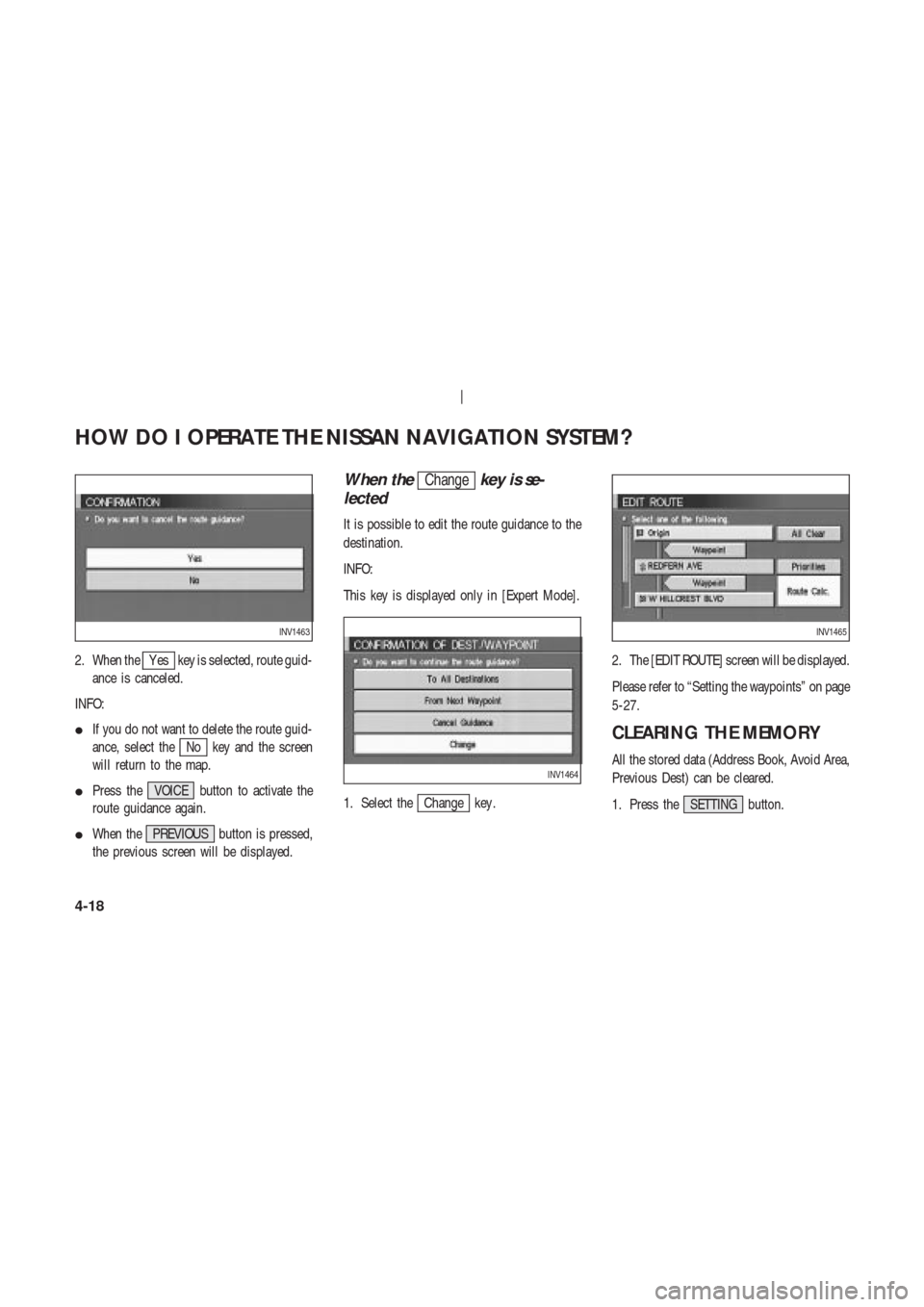
When theChangekey is se-
lected
It is possible to edit the route guidance to the
destination.
INFO:
This key is displayed only in [Expert Mode].
1. Select the
Change key .2. The [EDIT ROUTE] screen will be displayed.
Please refer to “Setting the waypoints” on page
5-27.
CLEARING THE MEMORY
All the stored data (Address Book, Avoid Area,
Previous Dest) can be cleared.
1. Press the SETTING button.
INV1463
INV1464
INV1465
HOW DO I OPERATE THE NISSAN NAVIGATION SYSTEM?
4-18
Page 37 of 174
. If your
trip is longer than 1,100 miles (1,770
km), please divide your trip by se-")
ABOUT ROUTE GUIDANCE
�The NISSAN Navigation System may
not calculate routes longer than
about 1,100 miles (1,770 km). If your
trip is longer than 1,100 miles (1,770
km), please divide your trip by se-
lecting one or two intermediate des-
tinations. Set your destination as the
first intermediate destination. Once
you pass the intermediate destina-
tion, you may set your final destina-
tion as your destination if it is within
1,100 miles (1,770 km). Otherwise,
set your destination using your sec-
ond intermediate destination.
NOTE:
The navigation system does not take
driving in “carpool lanes” into consid-
eration for the guidance, especially
when carpool lanes are separated from
other road lanes.
NOTES ON ROUTE GUIDANCE
�The route selected by the system may not
be the shortest, nor are other circumstances
such as traffic jams considered.
�Because of the inevitable difference in road
conditions and circumstances between the
time you use this system and the time the
information was produced for the DVD,
there may be discrepancies in roads and
regulations. In such cases, follow the actual
information available.
�During route calculation, the map will not
scroll, however the vehicle icon will move
with the actual vehicle’s movement.
�During route calculation, buttons such as
MAP , DEST , ZOOM OUT and
ZOOM IN and the joystick will be dis-
abled.
�In some cases, after the calculation is com-
plete, it may take some time to get the cal-
culated route on the display .�Waypoints that have been passed will not
be covered by the re-routing calculation.
�If you scroll the map while the suggested
route is being drawn, it may take more time
to finish drawing.
�If waypoints are set, the system is calculat-
ing multiple routes between waypoints si-
multaneously , and the following may result.
— If one section (or more) of the routes be-
tween the waypoints is not found, none of
the route will be displayed.
— The route may not connect completely at
some waypoints.
— The route may require a U-turn close to
some waypoints.
�Route calculation may not be completed in
the following cases.
— If there is no main road within 3.1 miles (5
km) from the vehicle, a message saying so
will appear on the screen. T ry requesting
HOW DO I OPERATE THE NISSAN NAVIGATION SYSTEM?
4-21
Page 38 of 174
 from the destination or waypoint, a
message saying so will appear on the
screen. T r")
route calculation when the vehicle is closer
to the main road.
— If there is no main road within 3.1 miles (5
km) from the destination or waypoint, a
message saying so will appear on the
screen. T ry setting the location closer to the
main road.
— If the vehicle is too close to the destination
or if there are no branches of the roads to
the destination. A message saying so will
appear on the screen.
— If it is deemed impossible to reach the des-
tination or waypoints because of traffic
regulations, etc.
— If the only route to reach the destination or
waypoints is extremely complicated.
— If the destination, current vehicle position
or waypoint is within the avoid area.
— If the setting of avoid areas covers the
routes to the destination, route calculationmay not be possible.
�The following may occur when the route is
being displayed.
— If you are requesting a calculation from the
main road, the origin of the route may not
exactly match the current vehicle position.
— If you are requesting a calculation to the
destination on the main road, the end of the
route may not exactly match the destination.
— If you are requesting a calculation from the
main road, the system may show a route
from another main road. This may be be-
cause the icon to show the current vehicle
position (vehicle icon) is not set accurately .
In that case, park the car in a safe place and
reset the vehicle icon, or continue driving
to see if the vehicle icon appears on the
main road before requesting route calcula-
tion again.
— There are cases in which the system shows
a detoured route to reach the destination orwaypoints, if you set them from memory or
facility information. In order to correct this,
you will have to be careful about the traffic
direction, especially when the lanes with
different travel directions are shown sepa-
rately . Such places are interchanges and
service areas.
— This system makes no distinction between
limited traffic control and total control
(blockage). It may show a detoured route
even if the road is usable.
— Even if the freeway preference is set to OFF ,
the route may be set on them. T o avoid this,
set a waypoint on another road type and re-
quest calculation.
— Even if the preference is set to OFF for a
ferry line, the route may be set on it. T o
avoid this, set a waypoint on a road and re-
quest calculation.
— Ferry lines, except those which accept only
pedestrians, bicycles and motorcycles, are
HOW DO I OPERATE THE NISSAN NAVIGATION SYSTEM?
4-22
Page 39 of 174

stored in this system. When using them,
take into consideration the travel time re-
quired and operational condition to decide
whether to use them or not.
ABOUT THE DISPLAY ERROR
The following cases may affect the display ac-
curacy of the vehicle’s position or travel direc-
tion. The accuracy will return to normal if the
driving conditions return to normal.
— When there is a similar road nearby .
— When the vehicle is traveling on a long
stretch of straight road or series of curves
with a large radius.
— When the vehicle is traveling in an area with
a grid road system.
— When the vehicle is making consecutive S
curves.
— When the vehicle is at a large Y -shaped
junction.— When the vehicle is on a loop bridge.
— When the vehicle is on a snow-covered or
unpaved road.
— When the vehicle has made several con-
secutive turns or zigzags.
— When the vehicle is rotated on a parking lot
turntable while the ignition switch is OFF .
— Immediately after the vehicle is driven out
of a parking garage or underground parking
lot.
— When the vehicle has different sizes of tires
or tire chains.
— When the vehicle is moved immediately af-
ter the engine is started.
HOW DO I OPERATE THE NISSAN NAVIGATION SYSTEM?
4-23
Page 42 of 174
V ARIOUS W A YS TO SET
THE DESTINA TION (OR
W A YPOINT)
WARNING
T o operate the navigation system or
to use the screen functions, first park
the vehicle in a safe place and set the
parking brake. Using the system
while driving can distract the driver
and may result in a serious accident.
EXPERT MODE CATEGORIES
T o set the destination and waypoints, you can
choose from the eight categories described be-
low. Use these options to choose the best way
to find the route to the destinations and
waypoints.
�Address Book
�Previous Dest.
�Address/Street
�Intersection�Point of Interest (POI)
�City
�Phone Number
�Map
EASY MODE CATEGORIES
When the Expert Mode is canceled, the follow-
ing three categories will be displayed as Easy
Mode.
�Home
�Address/Street
INV1453
INV1454
HOW DO I PROGRAM A DESTINATION?
5-2
Page 43 of 174

INFO:
�Use the
Address Book key and the
Point of Interest (POI) key in the same
way as in Expert Mode.
Please refer to “Setting with the
Address Book key” on page 5-3 and")
�Point of Interest (POI)
INFO:
�Use the
Address Book key and the
Point of Interest (POI) key in the same
way as in Expert Mode.
Please refer to “Setting with the
Address Book key” on page 5-3 and
“Setting with the
Point of Interest (POI)
key” on page 6-2.
�If the
Short Menus key is highlighted in
green in the [SETTING] screen, the screen
is in Easy Mode. In this case, the keys dis-
played are different from the screen in Ex-
pert Mode.
�If you set a destination or waypoints, they
will be displayed with icons.
�If you want to go to places close to the
stored locations or facilities, use categories
such as facility , nearby facility or memory
for easier setting.�When using either the Point of Interest
(POI) or nearby Points of Interest catego-
ries, the names called up can be set as the
destination if you do not scroll the screen.
If you want to choose a different place on
the screen from the one called up, you will
have to scroll the screen.
SETTING WITH THEAddress Book
KEY
The Address Book will allow you to store lo-
cations in the memory . This is especially useful
for locations that you visit frequently .
Please refer to “Setting up and editing the ad-
dress book” on page 7-2.1. Press the DEST button.
2. Select the
Address Book key on the
[DEST . SETTING] screen.
The [DEST . SETTINGS (Address Book)] screen
will be displayed.
INV1453
HOW DO I PROGRAM A DESTINATION?
5-3


WARNING
T o operate the navigation system or
to use the screen functions, first park
the vehicle in a safe place and set the
parking brake. Usin")