2019 MERCEDES-BENZ S CLASS service
[x] Cancel search: servicePage 314 of 578

#SelectYes.The automaticgasstation searchbegins. Theavailablegasstations alongtheroute or inthe vicinity are displayed.
#Selectthegasstation.#Whenthere is noroute,thegasstation is setasthe destination.
or
#Whenthere is aroute,thegasstation is setasthe next intermediate destination.
Startingthe automatic servicestationsearch
Requirements:RATTENTION ASSIST andtheSuggest RestAreafunction are activated (→page 238).
Driving situationTheATTENTION ASSIST Do you want to searchfor a rest area?message is shown.
#SelectYes.The servicestation search starts. Theavaila‐ble servicestations alongtheroute or inthe
vicinity ofthevehicle's current position aredisplayed.
#Selectthe servicestation.The servicestation address is displayed.#Ifroute guidance is not active, selectStartRoute Guidance.The selected servicestation is set as a desti‐nation.Route guidance begins.
or
#Ifroute guidance is active, selectStart NewRoute GuidanceorSet as Next Way Point.Start New Route Guidance:the selectedservicestation is set as a new destination.The previous destination and all intermediatedestinations are deleted.Route guidancetothe servicestation begins.
Set as Next Way Point:the selected servicestation is set asthe next intermediate desti‐nation.Route guidance begins.
Route guidance
Notes onroute guidance
&WARNINGRisk of distraction from oper‐ating integrated communication equip‐ment whilethevehicle is in motion
Ifyou operate communication equipmentintegrated inthevehicle when driving,youwill be distracted fromthe traffic situation.This could also causeyoutolose control ofthevehicle.
#Only operatethis equipment whenthetraffic situation permits.
#Ifyou cannot be sure ofthis,stopthevehicle whilst paying attentiontoroadand traffic conditions and operatetheequipment withthevehiclestationary.
You must observethe legalrequirementsforthecountry in whichyou are currently driving whenoperatingthe multimedia system.Route guidance begins once aroute has beencalculated.
312Multimedia system
Page 320 of 578

RRear Seat Entertainment System
%Received destinations are saved inthe previ‐ous destinations.
A promptappears onthe media display.
#A destination has beenreceived withoutpicture information:selectYes.
#Ifroute guidance is not active, selectStartRoute Guidance.Theroutetothe destination is calculated.The map shows theroute.Route guidancethen begins.
or
#Ifroute guidance is active, selectStart NewRoute GuidanceorSet as Next Way Point.Start New Route Guidance:thereceived des‐tination address is set as a new destination.The previous destinations and intermediatedestinations are deleted.Route guidancetothe new destination begins.
Set as Next Way Point:thereceived destina‐tion address is set asthe next intermediatedestination.Route guidance begins.
#A destination has beenreceived with pic‐tureinformation:selectStart Route Guid-ance.Route guidancestarts.#Aroute has beenreceived:selectStartRoute Guid. from Beginning of Route.
or
#SelectStart Route Guidance from CurrentPosition.Route guidancestarts fromthe selectedposition.
Route guidance with current trafficreports
Traffic informationoverviewTrafficreports arereceived using LiveTrafficInformation and are usedforroute guidance.
This service is unavailable in some countries.
There may be differences betweenthe trafficreportsreceived andthe actualroad and trafficconditions.
Important information on LiveTraffic Informa‐tion:
RCurrent trafficreports arereceived viatheInternet connection.
RThe traffic situation is updated at short,regu‐lar intervals.
RThe subscription information shows thesta‐tus (→page318).
Information onthevehicle's position isregularlysenttoDaimlerAG. The datais immediatelyren‐dered anonymousbyDaimlerAGandforwardedtothe traffic data provider. Usingthis data, traf‐ficreportsrelevanttothevehicle's position aresenttothevehicle. Thevehicle acts as a sensorfortheflowof traffic and helpstoimprovethequality ofthe trafficreports.
Ifyou do not wishtotransmityourvehicle posi‐tion,you can havethis service deactivated at anauthorized Mercedes-Benz Center.
Displaying subscription information
Requirements:RThevehicle is equipped with LiveTrafficInformation.
318Multimedia system
Page 323 of 578

• Filtersthe display of POIs inthe vicinityaccordingtoPOI category
5Switchesthe display of personal POI sym‐bols onthe map on or off
6Switches one ofthefollowing displayson oroff depending onthe equipment:
•Weather information
• Satellite map
•Traffic incidents
7Switchesthe traffic map display on or off
The map and satellite images are shown inglobeprojection. This allowsfor arealistic map displayin all map scales. The map uses elevation model‐ing.
Depending onthe map data, important buildingsin manycities are depictedrealistically onthemap in small map scales (e.g. 1/32 mi (20 m),1/16 mi (50 m)). Other buildings are shown asmodels.
%You can setthe unit of measurement ofthemap scale (→page 294).
If online information isavailable, fuel prices andtheavailability of parking spaces in parkinggarages are displayed,forexample.
%Requirements:
RMercedes me connect isavailable.
RYou havea user accountfortheMercedes me portal.
RThe service has been activated at anauthorized Mercedes-Benz Center.
Further information can befound at: http://www.mercedes.me
%The online information is notavailable in allcountries.
IfDisplay in COMANDis activated inTraffic SignAssist (→page240), speed limits andovertakingrestrictions are displayed onthe map.
%Company logos displayed onthe map aretrademarksoftherespective companies andused solelyforthe purpose of indicatingthelocations ofthese companies. The use ofsuch logos onthe map does not indicateapproval of, supportof or advertisingby
these companiesforthe navigation systemitself.
Settingthe map scale
Requirements:RThe map is shown.
Multimedia system:
,Navigation
#Tozoom in:swipe down ontheTouch Con‐trol.
or
#Turnthe controller counter-clockwise.
or
#Movetwofingers apart onthetouchpad.#Tozoom out:swipe up ontheTouch Control.
or
#Turnthe controller clockwise.
or
#Movetwofingerstogether onthetouchpad.
%You can setthe unit of measurement ofthemap scale (→page 294).
Multimedia system321
Page 327 of 578

For automatic map updatesAutomaticOnline Updatemust be activated inthe sys‐tem settings (→page 297).
Rthe manual map update updates map datafor several or allregions.
Further information onthe online map update isavailable at an authorized Mercedes-Benz Centeror at http://www.mercedes.me.
Further information on updates: http://manuals.daimler.com/baix/cars/connectme/en_GB/index.html.
Overview of map dataYourvehicle is supplied with map data atthefac‐tory. Depending onthe country, map dataforyourregion is either pre-installed orthe mapdata is supplied on a datastorage medium.
Ifthe map data onyourvehicle has been instal‐led atthefactory andyou wishtoreinstall it,youdo not needtoenterthe activation code.
For map datathatyou havepurchased intheformof a datastorage medium,you must enterthe accompanying activation code.
%Ifyou savethe map data on a datastoragemedium withthe online map update service,no entryisrequired. The activation code isstored onthe datastorage medium duringthe downloading process.
Observethefollowing when enteringthe activa‐tion code:
RThe activation code can be usedfor onevehi‐cle
RThe activation code is not transferable
RThe activation code has six digits
Intheevent ofthefollowing problems, pleasecontact an authorized Mercedes-Benz Center:
RThe multimedia system does not accepttheactivation code
RYou havelostthe activation code
Displayingthe compassMultimedia system:
,Navigation.ÀRoute and Position
#SelectCompass.
The compass display showsthefollowinginformation:
Rthe current direction of travel with bear‐ing (360°format) and compass direction
Rlongitude and latitude coordinates indegrees, minutes and seconds
Rheight (rounded)
Rnumber of GPS satellites from which asignal can bereceived
Settingthe map scale automaticallyMultimedia system:
,Navigation.ZOptions
The map scale is set automatically depending onyour driving speed.
For journeysin cities with detailed city models, amap view fromthe driver's perspective is used.
#SwitchAuto Zoomon�sor off�S.
Multimedia system325
Page 328 of 578

%The automatically selected map scale can bechanged manuallyfor a short time. The set‐ting isreset automatically after afew sec‐onds.
Displayingthe satellite mapMultimedia system:
,Navigation.ZOptions.Map
Content
#SwitchSatellite Mapon�sor off�S.
or
#If satellite map display6isavailable inthemap menu, switch it on�sor off�S(→page 320).Switched on�s: satellite maps are displayedin map scales of 2 mi (2 km) or less.
Switched off�S: satellite maps are not dis‐played in map scales from 2 mi (2 km)to10mi (10 km).
%Satellite mapsforthese map scales are notavailable in all countries.
Displayingweather information
Requirements:RMercedes me connect isavailable.
RYou havea user accountforthe Mercedesme portal.
RThe service isavailable.
RThe service has been activated at an author‐ized Mercedes-Benz Center.
Further information can befound at: http://www.mercedes.me
Multimedia system:
,Navigation.ZOptions.Map
Content
#ActivateWeather Information�s.
or
#Ifweather information display6isavailableinthe map menu, activate�s(→page 320)it.Currentweather information is displayed onthe navigation map, e.g.temperature orcloud cover.
%Weather information is notavailable in allcountries.
Calling upthe Digital Operator's Manual(navigation)
Calling up information on navigationMultimedia system:
,Navigation.ZOptions.Naviga-
tion Info
#Selectthetopic.
Telephone
Telephony
Notes ontelephony
&WARNINGRisk of distraction from oper‐ating integrated communication equip‐ment whilethevehicle is in motion
Ifyou operate communication equipmentintegrated inthevehicle when driving,youwill be distracted fromthe traffic situation.
326Multimedia system
Page 341 of 578

%The service provider isresponsiblefortheseapps andthe services and content connec‐tedtoit.
Connecting Mercedes-Benz Link withthemultimedia system#Connectthe Mercedes-Benz Link control boxwiththe�
Page 345 of 578

Thefollowing system information is transmitted:
RSoftwarerelease ofthe multimedia system
RSystem ID (anonymized)
The transfer ofthis data is usedtooptimize com‐munication betweenthevehicle andthe mobilephone.
Todothis, andtoassign severalvehiclestothemobile phone, avehicle identifier israndomlygenerated.
This has no connectiontothevehicle identifica‐tion number (VIN) and is deleted whenthe multi‐media system isreset (→page 298).
Thefollowing drivingstatus data is transmitted:
RTransmission position engaged
RDistinction between parking,standstill,roll‐ing and driving
RDay/night mode ofthe instrument cluster
The transfer ofthis data is usedtoalter howcontent is displayedtocorrespondtothe drivingsituation.
Thefollowing position data is transmitted:
RCoordinates
RSpeed
RCompass direction
RAcceleration direction
This datais only transferred whilethe navigationsystem is active in ordertoimproveit (e.g. so itcan continue functioning when in a tunnel).
Mercedes me connect
Notes on Mercedes me connect
Mercedes me connect providesthefollowingservices:
RAccident and breakdown management (mebutton)
RConcierge Service (whenthe service is acti‐vated), appointmentrequests or similar (mebutton)
RMercedes-Benz emergency call system (auto‐matic emergency call or SOS button)
The Mercedes-Benz Customer Center andtheMercedes-Benz emergency call center areavaila‐bleforyou aroundthe clock.
The me button andthe SOS button can befoundonthevehicle'soverhead control panel(→page 344).
You can also callthe Mercedes-Benz CustomerCenter usingthe multimedia system(→page 344).
Please notethat Mercedes me connect is aMercedes-Benz service. In emergencies, alwayscallthe national emergency servicesfirst usingthestandard national emergency service phonenumbers. In emergencies,you can also usetheMercedes-Benz emergency call system(→page 346).
Observethe conditions of usefor Mercedes meconnect andother services. These can beobtained inthe Mercedes me portal: https://me.secure.mercedes-benz.com
Multimedia system343
Page 346 of 578

Callingthe Mercedes-Benz Customer Centerusing the multimedia system
Requirements:RYou haveaccesstoa GSM network.
RThe contract partner's GSM network cover‐age isavailable intherespectiveregion.
RThe ignition is switched on sothatvehicledata can be transferred automatically.
Multimedia system:
,Phone.ªContacts
#CallMercedes me connect.The call is made.
Then,you can select a service and be con‐nectedtoa specialist atthe Mercedes-BenzCustomer Center.
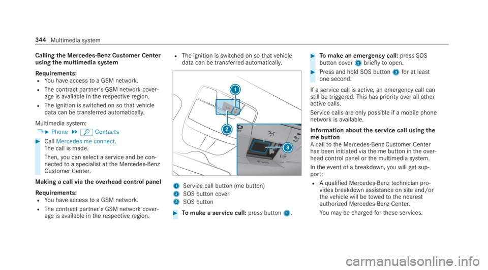
Making a call viatheoverhead control panel
Requirements:RYou haveaccesstoa GSM network.
RThe contract partner's GSM network cover‐age isavailable intherespectiveregion.
RThe ignition is switched on sothatvehicledata can be transferred automatically.
1Service call button (me button)
2SOS button cover
3SOS button
#Tomake a service call:press button1.
#Tomake an emergency call:press SOSbutton cover2brieflytoopen.
#Press and hold SOS button3for at leastone second.
If a service call is active, an emergency call canstill be triggered. This has priorityover allotheractive calls.
Service calls are only possible if a mobile phonenetwork isavailable.
Information aboutthe service call usingthemebuttonA calltothe Mercedes-Benz Customer Centerhas been initiated viathe me button intheover‐head control panel orthe multimedia system.
Intheevent of a breakdown,you willget sup‐port:
RAqualified Mercedes-Benztechnician pro‐vides breakdown assistance on site and/orthevehicle will betowedtothe nearestauthorized Mercedes-Benz Center.
You may bechargedforthese services.
344Multimedia system