2019 INFINITI QX50 information screen
[x] Cancel search: information screenPage 188 of 288

9. Navigation (if so equipped)
reception being available.
Searching by connecting Data Cen-
ter
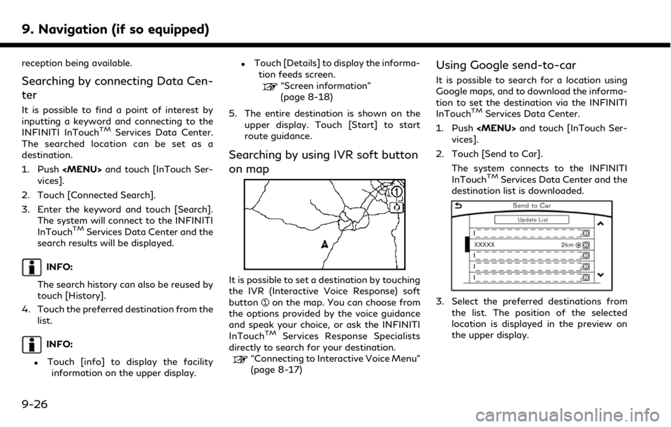
It is possible to find a point of interest by
inputting a keyword and connecting to the
INFINITI InTouch
TMServices Data Center.
The searched location can be set as a
destination.
1. Push
Page 195 of 288

areas. Voice guidance will not be provided in
these areas.” When approaching the end-
point of the suggested road, voice guidance
will announce, “Entering the road with
incomplete map data. Please use the direc-
tion arrow and distance information to
proceed to your destination.”
Route guidance screens
Various guidance screens are displayed on
the upper display during route guidance.
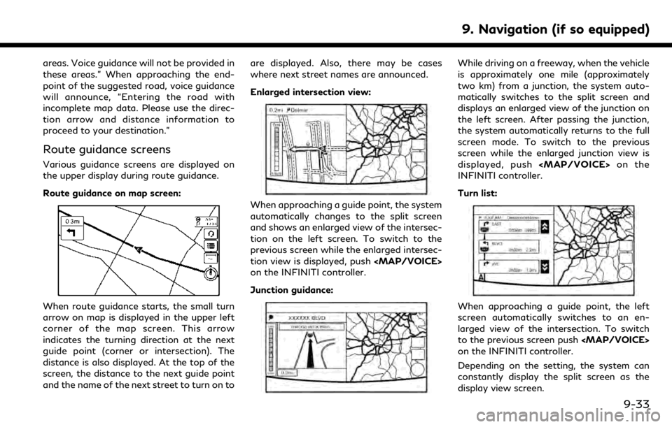
Route guidance on map screen:
When route guidance starts, the small turn
arrow on map is displayed in the upper left
corner of the map screen. This arrow
indicates the turning direction at the next
guide point (corner or intersection). The
distance is also displayed. At the top of the
screen, the distance to the next guide point
and the name of the next street to turn on toare displayed. Also, there may be cases
where next street names are announced.
Enlarged intersection view:
When approaching a guide point, the system
automatically changes to the split screen
and shows an enlarged view of the intersec-
tion on the left screen. To switch to the
previous screen while the enlarged intersec-
tion view is displayed, push
Page 196 of 288
![INFINITI QX50 2019 Navigation Manual 9. Navigation (if so equipped)
Showing freeway exit information:
When [Show FWY Exit] is set to ON and the
route includes a freeway or toll road, all exits
along the route which have exit information
INFINITI QX50 2019 Navigation Manual 9. Navigation (if so equipped)
Showing freeway exit information:
When [Show FWY Exit] is set to ON and the
route includes a freeway or toll road, all exits
along the route which have exit information](/manual-img/42/34995/w960_34995-195.png)
9. Navigation (if so equipped)
Showing freeway exit information:
When [Show FWY Exit] is set to ON and the
route includes a freeway or toll road, all exits
along the route which have exit information
will be shown in the turn list. The exit
information is shown as icons.
Selecting a waypoint from the exit infor-
mation list:
When exit information is displayed on the
turn list, a facility located near the freeway
exit can be set as a waypoint. The facility
categories that are not shown with an icon
cannot be selected.
1. Touch the exit where the exit informa-tion icon is displayed. The category list
screen is displayed.
2. Touch the landmark category. The list screen for showing facilities located near
the freeway exit is displayed.
INFO:
The facility categories that are not
shown with an icon cannot be selected.
3. Touch the preferred facility for the waypoint.
4. The waypoint is set, and the route search is performed.
“Procedures after setting route”
(page 9-27)
GUIDANCE SCREEN SETTINGS
The guidance screen can be displayed at all
times even when the vehicle is located away
from the guide point. Various types of
screens can be set.
“Display View Bar” (page 2-12)
CANCELING ROUTE
It is possible to delete a destination and all
waypoints that have already been set.
1. Push
2. Touch [Cancel Route].
3. A confirmation message is displayed.
The destination and the waypoints are
deleted.
INFO:
The deleted destination and waypoints
cannot be reactivated.
ROUTE MENU SCREEN
WARNING
Always stop the vehicle in a safe location
before modifying the route conditions.
Modifying the route conditions while
driving may cause an accident.
During route guidance, the route conditions
9-34
Page 197 of 288

can be modified and the route information
can be confirmed. Set route conditions
according to your personal preference.
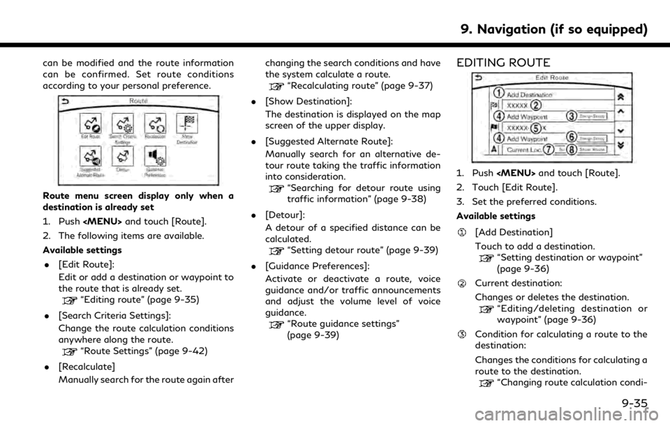
Route menu screen display only when a
destination is already set
1. Push
2. The following items are available.
Available settings . [Edit Route]:
Edit or add a destination or waypoint to
the route that is already set.
“Editing route” (page 9-35)
. [Search Criteria Settings]:
Change the route calculation conditions
anywhere along the route.
“Route Settings” (page 9-42)
. [Recalculate]
Manually search for the route again after changing the search conditions and have
the system calculate a route.
“Recalculating route” (page 9-37)
. [Show Destination]:
The destination is displayed on the map
screen of the upper display.
. [Suggested Alternate Route]:
Manually search for an alternative de-
tour route taking the traffic information
into consideration.
“Searching for detour route using
traffic information” (page 9-38)
. [Detour]:
A detour of a specified distance can be
calculated.
“Setting detour route” (page 9-39)
. [Guidance Preferences]:
Activate or deactivate a route, voice
guidance and/or traffic announcements
and adjust the volume level of voice
guidance.
“Route guidance settings”
(page 9-39)
EDITING ROUTE
1. Push
2. Touch [Edit Route].
3. Set the preferred conditions.
Available settings
[Add Destination]
Touch to add a destination.
“Setting destination or waypoint”
(page 9-36)
Current destination:
Changes or deletes the destination.
“Editing/deleting destination or
waypoint” (page 9-36)
Condition for calculating a route to the
destination:
Changes the conditions for calculating a
route to the destination.
“Changing route calculation condi-
9. Navigation (if so equipped)
9-35
Page 200 of 288

9. Navigation (if so equipped)
INFO:
. When a waypoint has been set on the
route, the system will search for only one
route, even if route recalculation is
performed.
. When the vehicle deviates from the
suggested route, the route from the
current location to the destination is
automatically searched again by the
Auto Reroute function.
“Route Settings” (page 9-42)
SEARCHING FOR DETOUR
ROUTE USING TRAFFIC INFOR-
MATION
When a serious traffic event occurs on the
route, or if the system finds a faster route, a
detour alert will display automatically. If the
automatic alert is not noticed, a detour can
also be searched for manually.
1. Push
2. Touch [Suggested Alternate Route].
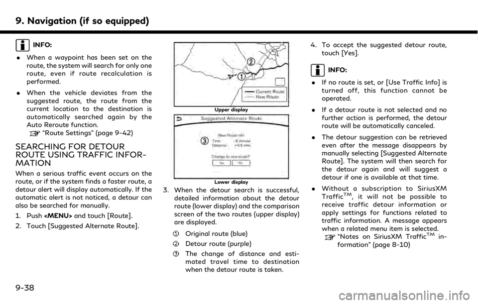
Upper display
Lower display
3. When the detour search is successful, detailed information about the detour
route (lower display) and the comparison
screen of the two routes (upper display)
are displayed.
Original route (blue)
Detour route (purple)
The change of distance and esti-
mated travel time to destination
when the detour route is taken. 4. To accept the suggested detour route,
touch [Yes].
INFO:
. If no route is set, or [Use Traffic Info] is
turned off, this function cannot be
operated.
. If a detour route is not selected and no
further action is performed, the detour
route will be automatically canceled.
. The detour suggestion can be retrieved
even after the message disappears by
manually selecting [Suggested Alternate
Route]. The system will then search for
the detour again and will suggest a
detour if one is available at that time.
. Without a subscription to SiriusXM
Traffic
TM, it will not be possible to
receive traffic detour information or
apply settings for functions related to
traffic information. A message appears
when a related menu item is selected.
“Notes on SiriusXM TrafficTMin-
formation” (page 8-10)
9-38
Page 201 of 288
![INFINITI QX50 2019 Navigation Manual Automatic detour guidance
When [Auto Reroute] and [Use Traffic Info]
are turned on in the detailed route settings, a
message will be displayed automatically
when the system finds a detour.
“Route Se INFINITI QX50 2019 Navigation Manual Automatic detour guidance
When [Auto Reroute] and [Use Traffic Info]
are turned on in the detailed route settings, a
message will be displayed automatically
when the system finds a detour.
“Route Se](/manual-img/42/34995/w960_34995-200.png)
Automatic detour guidance
When [Auto Reroute] and [Use Traffic Info]
are turned on in the detailed route settings, a
message will be displayed automatically
when the system finds a detour.
“Route Settings” (page 9-42)
Upper display
Lower display
To accept the suggested detour route, touch
[Yes].
INFO:
. If no operation is performed for one
minute after the message is displayed,
the message disappears. The detour will
not be accepted, and the current sug-
gested route will remain unchanged.
. When [Traffic Announcement] is turned
on in the guidance settings, the system
will announce voice guidance at the same
time that the message appears on the
screen.
“Guidance settings” (page 9-39)
SETTING DETOUR ROUTE
To detour from the suggested route, a route
detouring for a specified distance can be
calculated.
1. Push
upper half display.
2. Touch [Detour].
3. Touch a detour distance select from 1/2 mile, 1 mile, 3 miles or 5 miles. After
calculating the detour, the system dis-
plays the detour route on the map.
INFO:
. When the vehicle has deviated from the
suggested route, [Detour] cannot be
selected.
. If the system cannot calculate a detour
with the specified conditions the pre-
vious suggested route is displayed.
. If the vehicle is traveling very fast, the
detour route may start from a location
that the vehicle has already passed.
ROUTE GUIDANCE SETTINGS
The route search conditions and route
guidance can be set.
1. Push
2. Touch [Navigation].
3. Touch the item you would like to set.
Guidance settings
Various guidance information can be set to
be played during route guidance and the
route and/or voice guidance can be acti-
vated or deactivated.
9. Navigation (if so equipped)
9-39
Page 205 of 288
![INFINITI QX50 2019 Navigation Manual [Auto Reroute]If the vehicle deviates from the suggested route, the system
automatically recalculates a route that leads the vehicle to the
suggested route.
INFO:
. Only one of these route condition c INFINITI QX50 2019 Navigation Manual [Auto Reroute]If the vehicle deviates from the suggested route, the system
automatically recalculates a route that leads the vehicle to the
suggested route.
INFO:
. Only one of these route condition c](/manual-img/42/34995/w960_34995-204.png)
[Auto Reroute]If the vehicle deviates from the suggested route, the system
automatically recalculates a route that leads the vehicle to the
suggested route.
INFO:
. Only one of these route condition can be
utilized at a time.
. The recalculated route may not be the
shortest route because the system prior-
itizes roads that are easy to drive on for
safety reasons.
. If route conditions are set from [Search
Criteria], all sections in the route are
subject to the same route conditions
even though different route conditions
have been set for different sections in
[Edit Route].
. If [Use Time Restricted Roads] is deac-
tivated, the system calculates a route
without any consideration of the regula-
tions concerning the time or day of the
week. Therefore, the suggested route
may include a road subject to traffic
regulations concerning the time or day of
the week. When driving along the route,
always follow all traffic regulations
regardless of whether [Use Time Re-
stricted Roads] is set to be considered or not.
. If the system cannot calculate any alter-
native routes, the previous route is
displayed.
. If the vehicle greatly deviates from the
suggested route, the system calculates a
new route.
. Traffic jam information displayed on the
map screen is not statistical traffic
information.
. Even when [Use Real Time Traffic Info]
is turned on, if traffic information has not
been provided for the area, a detour may
not always be indicated in a location
where a traffic jam occurs.
. The system may not lead to a detour if
traffic closure or a traffic jam occurs far
from the present location.
. The system calculates to reduce the time
required for the entire route from the
start to the destination. If there are no
appropriate routes, the system may lead
to a route where a traffic jam occurs instead of leading to a detour.
9. Navigation (if so equipped)
9-43
Page 206 of 288

9. Navigation (if so equipped)
VIEWING TRAFFIC INFORMA-
TION
SiriusXM TrafficTMinformation is a sub-
scription service offered by SiriusXM® Sa-
tellite Radio.
This service provides real-time information
regarding traffic flow, accidents, road con-
struction and other incidents, where avail-
able.
SiriusXM Traffic
TMcombines information
from commercial and public traffic data
providers including government depart-
ments of transportation, police, emergency
services, road sensors, cameras and aircraft
reports. The traffic information is broadcast
to the vehicle by the SiriusXM® satellites.
Traffic information available for the route
the driver selected is shown on the naviga-
tion screen so traffic conditions between
you and the destination are known. Three
types of real-time traffic information for
major roadways are shown on the naviga-
tion system:
. Unscheduled traffic data for example,
accidents and disabled vehicles.
. Scheduled traffic data, for example road
construction and road closures. .
Traffic flow information (rate of speed
data).
WARNING
SiriusXM TrafficTMinformation is not a
substitute for attentive driving. Traffic
conditions change constantly and emer-
gency situations can arise without warn-
ing. Relying only on SiriusXM Traffic
TM
information may lead to a collision and
could result in serious personal injury.
NOTE:
Flow information is provided only for roads
equipped with traffic sensors and is not
available in all markets covered by the
service. Flow data may not be available on
portions of a road that is under construc-
tion.
SiriusXM Traffic
TMinformation is available
in limited markets. To subscribe or to check if
this service is available in the area:
call 1-866-635-2349 or see www.siriusxm.
com/siriusxmtraffic
INFO:
If a contract is not completed for SiriusXM
Traffic
TMinformation service, a message
appears, and it will not be possible to check
the information on the traffic information
system.
9-44