Page 89 of 164
[NissanConnect Services]Display the NissanConnectSMServices menu.“NissanConnectSMServices” (page 7-14)
[SXM Info] Display the SiriusXM Travel Link information menu.
“Viewing SiriusXM Travel Link�Š” (page 7-8)
INFO:
. A SiriusXM Travel Link or SiriusXM Traffic subscription is necessary to receive SiriusXM information services.
. Use of NissanConnect
SMServices features is dependent upon a valid subscription and the telematics device being in operative condition, as well as
cellular connectivity, navigation map data and GPS satellite signal reception being available.
7-3
7. Information and settings
Page 90 of 164

SiriusXM TRAFFIC INFORMA-
TION
VIEWING TRAFFIC INFORMATION
SiriusXM Traffic information is a subscription
service offered by SiriusXM Satellite Radio.
This service provides real-time information re-
garding traffic flow, accidents, road construction
and other incidents, where available.
SiriusXM Traffic combines information from
commercial and public traffic data providers
including government departments of transpor-
tation, police, emergency services, road sensors,
cameras and aircraft reports. The traffic informa-
tion is broadcast to the vehicle by the SiriusXM
satellites. Traffic information available for the
route you selected is shown on the navigation
screen so traffic conditions between your vehicle
and the destination are known. Three types of
real-time traffic information for major roadways
are shown on the navigation system: . Unscheduled traffic data for example, acci-
dents and disabled vehicles.
. Scheduled traffic data, for example road
construction and road closures.
. Traffic flow information (rate of speed data) .
WARNING
SiriusXM Traffic information is not a
substitute for attentive driving. Traffic
conditions change constantly and emer-
gency situations can arise without warn-
ing. Relying only on SiriusXM Traffic
information may lead to a collision and
could result in serious personal injury.
NOTE:
Flow information is provided only for roads
equipped with traffic sensors and is not
available in all markets covered by the
service. Flow data may not be available on
portions of a road that is under construc-
tion.
SiriusXM Traffic information is available in for a
limited number of markets. To subscribe or to
check if this service is available in your area:
call 1-866-635-2349 or see www.siriusxm.com/
siriusxmtraffic
INFO:
If you do not have a contract for SiriusXM Traffic
information service, a message appears, and it
will not be possible to check the information on
the traffic information system.
VIEWING AVAILABLE TRAFFIC IN-
FORMATION
1. Push .
2. Touch [Traffic Information].
3. Touch the preferred information.
7-4
7. Information and settings
Page 91 of 164
![NISSAN PATHFINDER 2017 R52 / 4.G Navigation Manual Availableitem Action
[Nearby
Traffic Info] The list of available traffic information
around the current vehicle location is
displayed.
[Info on
Route] This is only available when a route is
set. The l](/manual-img/5/542/w960_542-90.png "NISSAN PATHFINDER 2017 R52 / 4.G Navigation Manual Availableitem Action
[Nearby
Traffic Info] The list of available traffic information
around the current vehicle location is
displayed.
[Info on
Route] This is only available when a route is
set. The l")
Availableitem Action
[Nearby
Traffic Info] The list of available traffic information
around the current vehicle location is
displayed.
[Info on
Route] This is only available when a route is
set. The list of traffic information
found on the recommended route
from the current vehicle location to
the destination is displayed. The
detailed information about displayed
events can also be checked.
Viewing traffic information list
The list of traffic information found on the
recommended route from the current vehicle
location to the destination is displayed. The
detailed information about displayed events can
also be checked.
1. Push
.
2. Touch [Traffic Information].
3. Touch [Nearby Traffic Info] or [Info on Route].
4. Touch the preferred information from Traffic info screen.
5. Touch the event to check the detailedinformation. Touch [Map] to display traffic
information location.
6. The map screen centered around the se-lected event is displayed. On the display, the
detailed information about the event is
displayed.
The message can be scrolled.
7. Touch [
] to return to the previous screen.
DISPLAY URGENT TRAFFIC INFOR-
MATION
When an urgent event is found around the
current vehicle location, a message pops up
automatically with a voice announcement.
The message includes the icon, event type, event
information and the direct distance from the
current location to the event.
INFO:
. Urgent traffic information is displayed re-
gardless of whether the traffic information
system is on or off.
. When there are multiple urgent events, the
event with the shortest direct distance from
the current location is displayed.
. If the urgent event is on the recommended
route, and if a detour is found, the detour
route notification screen is displayed when
the vehicle approaches the detour point.
7-5
7. Information and settings
Page 92 of 164
![NISSAN PATHFINDER 2017 R52 / 4.G Navigation Manual TRAFFIC INFORMATION SETTINGS
This displays or changes the settings for the
traffic information related functions.
1. Push<SETTING>.
2. Touch [Navigation].
3. Touch [Traffic Info Settings].
4. Touch th](/manual-img/5/542/w960_542-91.png "NISSAN PATHFINDER 2017 R52 / 4.G Navigation Manual TRAFFIC INFORMATION SETTINGS
This displays or changes the settings for the
traffic information related functions.
1. Push<SETTING>.
2. Touch [Navigation].
3. Touch [Traffic Info Settings].
4. Touch th")
TRAFFIC INFORMATION SETTINGS
This displays or changes the settings for the
traffic information related functions.
1. Push.
2. Touch [Navigation].
3. Touch [Traffic Info Settings].
4. Touch the preferred setting. The indicator for the selected setting illuminates.
Available setting items . [Use Traffic Info]:
Enables all traffic information related func-
tions.
. [Show Incidents on Map]:
Displays the traffic incidents (e.g., accident)
on the map screen.
. [Show Traffic Info]:
Displays the traffic flow with an arrow on the
map screen. .
[Traffic Announcements]:
Announces the traffic information event on
the route.
INFO:
. Even when [Show Traffic Info] and [Show
Incidents on Map] are set to off, the list
display of [Info on Route] and [Nearby Traffic
Info] will not be affected.
. Even when [Traffic Announcement] is set to
off, the route guidance will not be affected.
Also, the announcement of emergency in-
formation and weather information will not be
turned off.
Voice command
1. Push <
>located on the steering-wheel.
2. After the tone sounds, speak a command. To turn the traffic information system on or
off:
“Traffic Information”
TRAFFIC INFORMATION ON MAP
With a subscription to SiriusXM Traffic service,
traffic information is displayed on both 2D map
and Birdview
TMmap screen.
“Notes on SiriusXM Traffic information”
(page 7-13)
Screen information
7-6
7. Information and settings
Page 93 of 164

*1Traffic indicator:
Displays the reception condition of traffic
information transmitted from the provider.When reception condition of traffic
information transmitted from the provider is
not detected, the traffic indicator will be
“grayed-out”.
*2Estimated travel time to destination calcu-
lated with consideration of traffic informa-
tion on route.
*3Road conditions
Free Flow: Green arrow
Moderate traffic: Yellow arrow
Heavy traffic: Red arrow
Section affected by serious traffic event:
Purple arrow
*4Traffic information icon:
If a route is not already set, all of the traffic
information icons on the map screen are
displayed in color. When a route is already
set, the icons on the route are displayed in
color, and the icons outside the route are
displayed in gray.
: Accident
: Closed road
: Information
: Road work
: Slippery road
: Weather
: Incident
Traffic information display and scale levels
2D map and Birdview Map
5 miles 10 km
2 miles 4 km
1 mile 2 km
1/2 mile 1 km
1/4 mile 400 m
1/8 mile 200 m
1/16 mile 100 m
1/32 mile 50 m
1/64 mile 25 m
SiriusXM TRAVEL LINK�Š
SiriusXM Travel Link information is a subscription
service offered by SiriusXM Satellite Radio. It is
necessary to subscribe to use the SiriusXM
Travel Link information.
This service provides real-time information re-
garding current weather, fuel prices, sports
scores, stock tickers and movie times where
available. The SiriusXM Travel Link is broadcast
to the vehicle by SiriusXM Satellite Radio.
The service enables you to view the following
information on the navigation system: *Current information around the destination
*Detailed information and forecasts of an area of
interest
*Countrywide and local maps with the current
weather, temperature, warnings and road condi-
tion information
*List of warning/watches events detected
around the current location
*Pop-up messages on the navigation screen with
voice announcements when warnings and
watches are detected around the current loca-
tion
7-7
7. Information and settings
Page 94 of 164
WARNING
SiriusXM Travel Link information is not a
substitute for attentive driving. Weather
conditions change constantly and emer-
gency situations can arise without warn-
ing. Relying only on SiriusXM Travel Link
information could result in serious per-
sonal injury.
VIEWING SiriusXM TRAVEL LINK�Š
SiriusXM Travel Link information is available in
limited markets. To subscribe to or check if this
service is available in the area, call 1-866-635-
2349 or access http://www.siriusxm.com/
travellink.
INFO:
. If a contract is not completed for the
SiriusXM Travel Link information service, a
message appears and it will not be possible
to check the information on the traffic
information system.
. The weather information is available only for
areas that provide weather information to SiriusXM Travel Link.
example
7-8
7. Information and settings
Page 95 of 164
![NISSAN PATHFINDER 2017 R52 / 4.G Navigation Manual Automotive Weather information
Step 1Step 2 Menu item Action
Push <INFO>. [SXM Info] [Automotive
Weather] [Current Weather] Display current weather condition information. Touch [Near Destination] to
d](/manual-img/5/542/w960_542-94.png "NISSAN PATHFINDER 2017 R52 / 4.G Navigation Manual Automotive Weather information
Step 1Step 2 Menu item Action
Push <INFO>. [SXM Info] [Automotive
Weather] [Current Weather] Display current weather condition information. Touch [Near Destination] to
d")
Automotive Weather information
Step 1Step 2 Menu item Action
Push . [SXM Info] [Automotive
Weather] [Current Weather] Display current weather condition information. Touch [Near Destination] to
display the current weather condition for the area near the destination, touch
[Near Current Loc.] to display the current weather conditions near the
vehicles current location. Touch [Selected City] to change the city.
[5-DAY Forecast] Display the current five-day weather forecast. Touch [Near Destination] to display the five-day weather forecast for area near the destination, touch
[Near Current Loc.] to display the five-day weather forecast for the area near
the vehicle’s current location. Touch [Selected City] to change the city.
[Graphical Map] Display a graphical map of the weather information. Touch [+]/[-] to change the map scale to 320 miles (640 km) (U.S), 32 miles (64 km) (Middle scale)
or 5 miles (10 km) (Detail scale). Touch [Radar] to display the weather radar
map. Touch [Chart] to display weather surface features and pressure, when
the map scale is U.S. (320 miles (640 km)). Touch [Storm] to display Storm
information, when the map scale is U.S. (320 miles (640 km)) or Middle
scale (32 miles (64 km)). Touch [Winds] to display wind information, when
map scale is Detail scale (5 miles (10 km)).
7-9
7. Information and settings
Page 96 of 164
![NISSAN PATHFINDER 2017 R52 / 4.G Navigation Manual Fuel Prices information
Step 1Step 2 Menu item Action
Push <INFO>. [SXM Info] [Fuel Prices] Display fuel prices. Select gas station from the fuel prices list to display
detail information or a call a](/manual-img/5/542/w960_542-95.png "NISSAN PATHFINDER 2017 R52 / 4.G Navigation Manual Fuel Prices information
Step 1Step 2 Menu item Action
Push <INFO>. [SXM Info] [Fuel Prices] Display fuel prices. Select gas station from the fuel prices list to display
detail information or a call a")
Fuel Prices information
Step 1Step 2 Menu item Action
Push . [SXM Info] [Fuel Prices] Display fuel prices. Select gas station from the fuel prices list to display
detail information or a call a selected gas station from the list.
Touch [Select Fuel] to select fuel type information, touch [Prices] to display
the fuel price list.
Touch [Near Current Loc.]/[Near Destination]/[Select Fuel] to sort by
distance or sort by prices from the list.
Set destination selected gas station from the list.
Sports Score information
Step 1 Step 2 Menu item Action
Push . [SXM Info] [Sports Scores] Select from list. Display current event state (scheduled
game, during the game, match results)
XM channels to display infor-
mation Select to listen to the radio.
[Select League] [Add League] Add favorite sports genre for the list. When
the number of registration is 10, it will be
grayed out.
[Delete League] [Multi Select] Delete multiple selected sports scores.
[Delete All] Delete all sports scores.
Select from
list.Delete a selected sports score.
Select from list. Display the detail of a score.
7-10
7. Information and settings
 1
1 2
2 3
3 4
4 5
5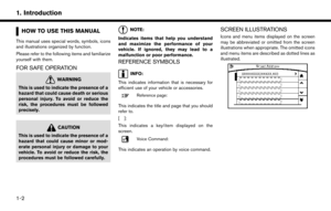 6
6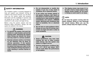 7
7 8
8 9
9 10
10 11
11 12
12 13
13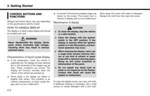 14
14 15
15 16
16 17
17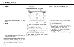 18
18 19
19 20
20 21
21 22
22 23
23 24
24 25
25 26
26 27
27 28
28 29
29 30
30 31
31 32
32 33
33 34
34 35
35 36
36 37
37 38
38 39
39 40
40 41
41 42
42 43
43 44
44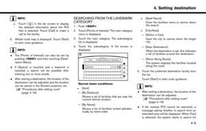 45
45 46
46 47
47 48
48 49
49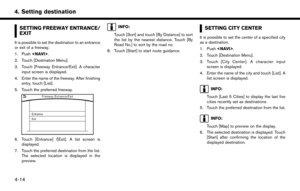 50
50 51
51 52
52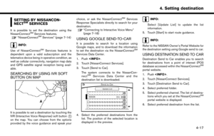 53
53 54
54 55
55 56
56 57
57 58
58 59
59 60
60 61
61 62
62 63
63 64
64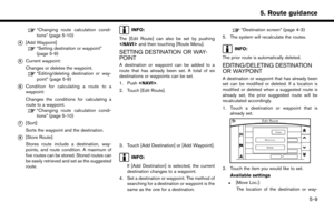 65
65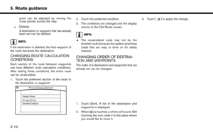 66
66 67
67 68
68 69
69 70
70 71
71 72
72 73
73 74
74 75
75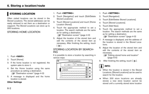 76
76 77
77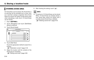 78
78 79
79 80
80 81
81 82
82 83
83 84
84 85
85 86
86 87
87 88
88 89
89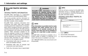 90
90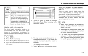 91
91 92
92 93
93 94
94 95
95 96
96 97
97 98
98 99
99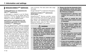 100
100 101
101 102
102 103
103 104
104 105
105 106
106 107
107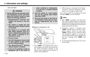 108
108 109
109 110
110 111
111 112
112 113
113 114
114 115
115 116
116 117
117 118
118 119
119 120
120 121
121 122
122 123
123 124
124 125
125 126
126 127
127 128
128 129
129 130
130 131
131 132
132 133
133 134
134 135
135 136
136 137
137 138
138 139
139 140
140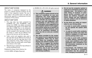 141
141 142
142 143
143 144
144 145
145 146
146 147
147 148
148 149
149 150
150 151
151 152
152 153
153 154
154 155
155 156
156 157
157 158
158 159
159 160
160 161
161 162
162 163
163![NISSAN PATHFINDER 2017 R52 / 4.G Navigation Manual [NissanConnect Services]Display the NissanConnectSMServices menu.“NissanConnectSMServices” (page 7-14)
[SXM Info] Display the SiriusXM Travel Link information menu.
“Viewing SiriusXM Travel Link](/manual-img/5/542/w960_542-88.png "NISSAN PATHFINDER 2017 R52 / 4.G Navigation Manual [NissanConnect Services]Display the NissanConnectSMServices menu.“NissanConnectSMServices” (page 7-14)
[SXM Info] Display the SiriusXM Travel Link information menu.
“Viewing SiriusXM Travel Link")
