2017 NISSAN MAXIMA change time
[x] Cancel search: change timePage 116 of 243
6. Navigation
US UnitsMetric Units
320 mi 640 km
80 mi 160 km
32 mi 64 km
8mi 16km
5mi 10km
2mi 4km
1mi 2km
1/2 mi 1 km
1/4 mi 500 m
1/8 mi 200 m
1/16 mi 100 m
1/32 mi 50 m
1/64 mi 25 m
INFO:
Depending on the map scale, traffic information
icons cannot be displayed on the map screen
(for U.S. and Canada) .
“Traffic information on map” (page 6-47)
CHANGING MAP
Changing map view and map orienta-
tion
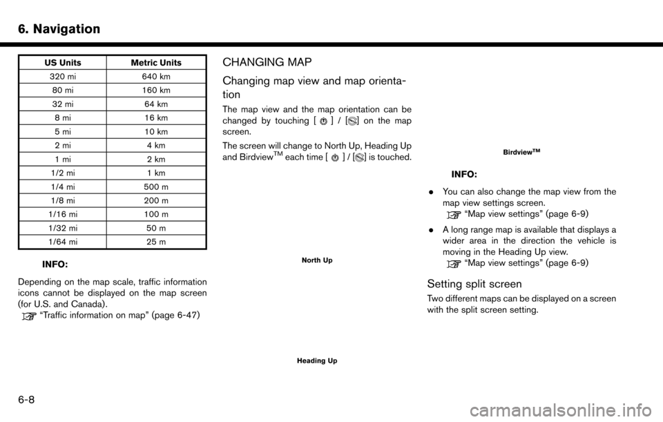
The map view and the map orientation can be
changed by touching []/[] on the map
screen.
The screen will change to North Up, Heading Up
and Birdview
TMeach time []/[] is touched.
North Up
Heading Up
BirdviewTM
INFO:
. You can also change the map view from the
map view settings screen.
“Map view settings” (page 6-9)
. A long range map is available that displays a
wider area in the direction the vehicle is
moving in the Heading Up view.
“Map view settings” (page 6-9)
Setting split screen
Two different maps can be displayed on a screen
with the split screen setting.
6-8
Page 147 of 243
![NISSAN MAXIMA 2017 A36 / 8.G Nissan Connect Navigation Manual 6. Touch [Calculate] to apply the change.
RECALCULATING ROUTE
A route can be manually searched again after
changing the search conditions, etc.
1. Touch [Navi] on the Launch Bar.
2. Touch [Recalculate NISSAN MAXIMA 2017 A36 / 8.G Nissan Connect Navigation Manual 6. Touch [Calculate] to apply the change.
RECALCULATING ROUTE
A route can be manually searched again after
changing the search conditions, etc.
1. Touch [Navi] on the Launch Bar.
2. Touch [Recalculate](/manual-img/5/539/w960_539-146.png)
6. Touch [Calculate] to apply the change.
RECALCULATING ROUTE
A route can be manually searched again after
changing the search conditions, etc.
1. Touch [Navi] on the Launch Bar.
2. Touch [Recalculate]. A message is displayedand the route is recalculated.
3. Touch [Start] or conduct other operations as necessary.
“Options before starting the route
guidance” (page 6-26)
INFO:
. When a waypoint has been set on the route,
the system will search for only one route,
even if route recalculation is performed.
. When the vehicle deviates from the sug-
gested route, the route from the current
location to the destination is automatically
searched again by the Auto Reroute func-
tion.
“Route Settings” (page 6-43)
SEARCHING FOR DETOUR ROUTE
USING TRAFFIC INFORMATION (for
U.S. and Canada)
When a serious traffic event occurs on the route,
or if the system finds a faster route, a detour alert
will display automatically. If the automatic alert is
not noticed, a detour can also be searched for
manually.
1. Touch [Navi] on the Launch Bar.
2. Touch [Traffic Detour].
3. When the detour search is successful,
detailed information about the detour route
and the comparison screen of the two routes
are displayed.
*1Original route (blue)
*2Detour route (purple)
*3The change of distance and estimated
travel time to destination when the
detour route is taken.
4. To accept the suggested detour route, touch [Yes].
INFO:
. Without a subscription to SiriusXM Traffic, it
will not be possible to receive traffic detour
information or apply settings for functions
related to traffic information. A message
appears when a related menu item is
selected.
“Notes on SiriusXM Traffic information”
(page 5-20)
. If no route is set, or [Use Real Time Traffic
Information] is turned off, this function cannot
be operated.
“Route Settings” (page 6-43)
. If a detour route is not selected and no
further action is performed, the detour route
will be automatically canceled.
. The detour suggestion can be retrieved even
after the message disappears by manually
selecting [Traffic Detour]. The system will
then search for the detour again and will
6. Navigation
6-39
Page 148 of 243
![NISSAN MAXIMA 2017 A36 / 8.G Nissan Connect Navigation Manual 6. Navigation
suggest a detour if one is available at that
time.
Automatic detour guidance
When [Auto Reroute] and [Use Real Time Traffic
Information] are turned on in the detailed route
settings, a m NISSAN MAXIMA 2017 A36 / 8.G Nissan Connect Navigation Manual 6. Navigation
suggest a detour if one is available at that
time.
Automatic detour guidance
When [Auto Reroute] and [Use Real Time Traffic
Information] are turned on in the detailed route
settings, a m](/manual-img/5/539/w960_539-147.png)
6. Navigation
suggest a detour if one is available at that
time.
Automatic detour guidance
When [Auto Reroute] and [Use Real Time Traffic
Information] are turned on in the detailed route
settings, a message will be displayed automati-
cally when the system finds a detour.
“Route Settings” (page 6-43)
To accept the suggested detour route, touch
[Yes].
INFO:
. If no operation is performed for 1 minute after
the message is displayed, the message
disappears. The detour will not be accepted,
and the current suggested route will remain
unchanged. .
When [Traffic Announcements] is turned on
in the guidance settings, the system will
announce voice guidance at the same time
the message appears on the screen.
“Guidance settings” (page 6-41)
SETTING DETOUR ROUTE
To detour from the suggested route, a route
detouring for a specified distance can be
calculated.
1. Touch [Navi] on the Launch Bar.
2. Touch [Detour].
3. Touch a detour distance select from 1/2 mile
(1km) , 1 mile (2km) , 3 miles (5km) or 5 miles
(10km) . After calculating the detour, the
system displays the detour route on the map.
INFO:
. When the vehicle has deviated from the
suggested route, [Detour] cannot be se-
lected.
. If the system cannot calculate a detour with
the specified conditions the previous sug-
gested route is displayed.
. If the vehicle is traveling very fast, the detour
route may start from a location that the
vehicle has already passed.
ROUTE GUIDANCE SETTINGS
The route search conditions and route guidance
can be set.
6-40
Page 154 of 243
6. Navigation
VIEWING TRAFFIC INFORMA-
TION (for U.S. and Canada)
SiriusXM Traffic information is a subscription
service offered by SiriusXM Satellite Radio.
This service provides real-time information re-
garding traffic flow, accidents, road construction
and other incidents, where available.
SiriusXM Traffic combines information from
commercial and public traffic data providers
including government departments of transpor-
tation, police, emergency services, road sensors,
cameras and aircraft reports. The traffic informa-
tion is broadcast to the vehicle by the SiriusXM
satellites. Available traffic information on the
route the driver selected is shown on the
navigation screen so traffic conditions between
you and the destination are known. Three types
of real-time traffic information for major roadways
are shown on the navigation system:
* Unscheduled traffic data for example, accidents
and disabled vehicles.
* Scheduled traffic data, for example road
construction and road closures.
* Traffic flow information (rate of speed data) .
WARNING
SiriusXM Traffic information is not a
substitute for attentive driving. Traffic
conditions change constantly and emer-
gency situations can arise without warn-
ing. Relying only on SiriusXM Traffic
information may lead to a collision and
could result in serious personal injury.
NOTE:
. Flow information is provided only for
roads equipped with traffic sensors and
is not available in all markets covered
by the service. Flow data may not be
available on portions of a road that is
under construction.
. A SiriusXM Traffic subscription is ne-
cessary to view Traffic Info.
“SiriusXM Travel Link (for U.S. and
Canada)” (page 5-19)
VIEWING AVAILABLE TRAFFIC IN-
FORMATION
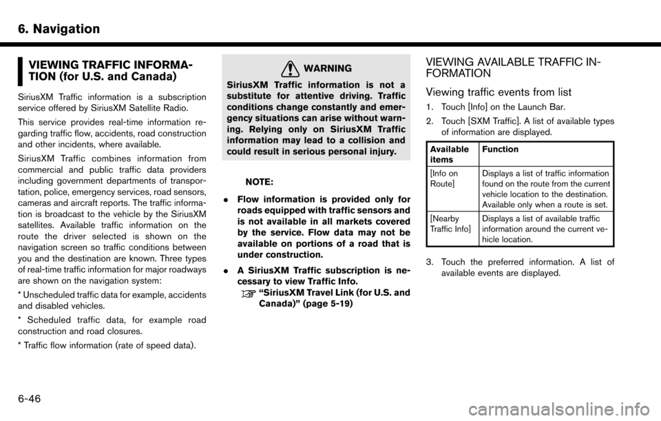
Viewing traffic events from list
1. Touch [Info] on the Launch Bar.
2. Touch [SXM Traffic]. A list of available types
of information are displayed.
Available
items Function
[Info on
Route] Displays a list of traffic information
found on the route from the current
vehicle location to the destination.
Available only when a route is set.
[Nearby
Traffic Info] Displays a list of available traffic
information around the current ve-
hicle location.
3. Touch the preferred information. A list of
available events are displayed.
6-46
Page 156 of 243
6. Navigation*
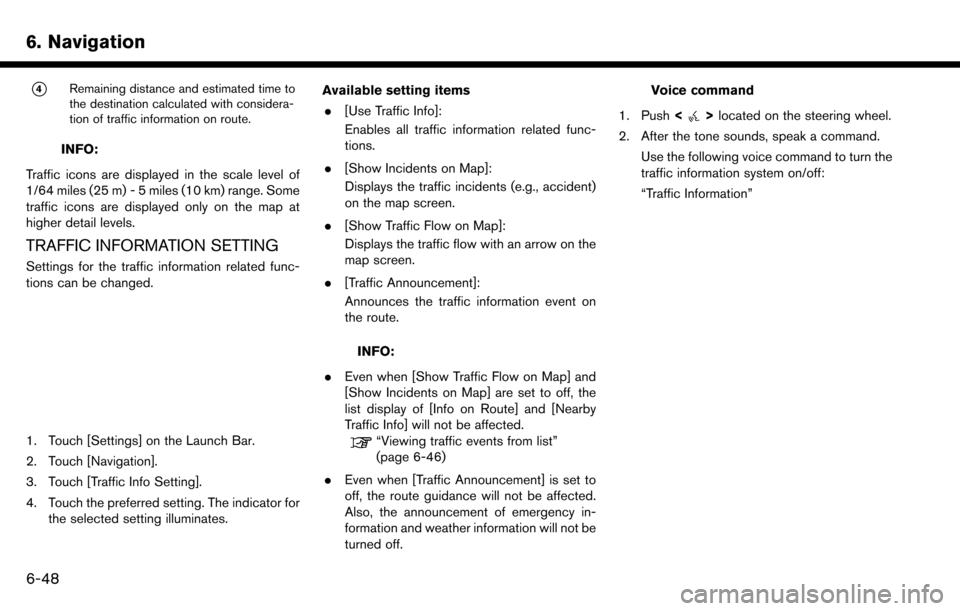
4Remaining distance and estimated time to
the destination calculated with considera-
tion of traffic information on route.
INFO:
Traffic icons are displayed in the scale level of
1/64 miles (25 m) - 5 miles (10 km) range. Some
traffic icons are displayed only on the map at
higher detail levels.
TRAFFIC INFORMATION SETTING
Settings for the traffic information related func-
tions can be changed.
1. Touch [Settings] on the Launch Bar.
2. Touch [Navigation].
3. Touch [Traffic Info Setting].
4. Touch the preferred setting. The indicator for the selected setting illuminates. Available setting items
. [Use Traffic Info]:
Enables all traffic information related func-
tions.
. [Show Incidents on Map]:
Displays the traffic incidents (e.g., accident)
on the map screen.
. [Show Traffic Flow on Map]:
Displays the traffic flow with an arrow on the
map screen.
. [Traffic Announcement]:
Announces the traffic information event on
the route.
INFO:
. Even when [Show Traffic Flow on Map] and
[Show Incidents on Map] are set to off, the
list display of [Info on Route] and [Nearby
Traffic Info] will not be affected.
“Viewing traffic events from list”
(page 6-46)
. Even when [Traffic Announcement] is set to
off, the route guidance will not be affected.
Also, the announcement of emergency in-
formation and weather information will not be
turned off.
Voice command
1. Push <
>located on the steering wheel.
2. After the tone sounds, speak a command. Use the following voice command to turn the
traffic information system on/off:
“Traffic Information”
6-48
Page 173 of 243
— The endpoint of the route may not exactlymatch the destination.
— If you calculate a route on a main road, the system may display a route from another
main road. This may be because the
position of the vehicle icon is not accu-
rate. In this case, park the vehicle in a safe
location and reset the vehicle icon, or
continue driving to see if the position of
the vehicle icon is automatically adjusted
before recalculating the route.
— There are cases in which the system shows an indirect route to reach the
destination or waypoints, if you set them
from stored or facility information. In order
to correct this, you must be careful about
the traffic direction, especially when lanes
with different travel directions are shown
separately, such as interchanges and
service areas.
— This system makes no distinction be- tween limited traffic control and total
control (blockage) . It may show an
indirect route even if the road is usable.
— Even if the ferry preference is set to OFF, a route that uses a ferry line may be
suggested.ROUTE GUIDANCE
INFO:
. For U.S. and Canada:
The system will announce street names
when the system language is set to English.
Street names are not announced when the
system is set to French/Spanish.
. For Mexico:
The system will announce street names
when the system language is set to Spanish.
Street names are not announced when the
system is set to English/French.
Repeating voice guidance
This function is available throughout route
guidance, from the time after the route calcula-
tion is completed until the vehicle arrives at the
destination. Push and hold the
Page 196 of 243
7. Voice recognition
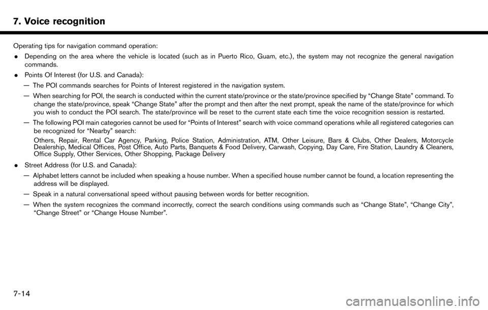
Operating tips for navigation command operation:. Depending on the area where the vehicle is located (such as in Puerto Rico, Guam, etc.) , the system may not recognize the general navigation
commands.
. Points Of Interest (for U.S. and Canada):
— The POI commands searches for Points of Interest registered in the navigation system.
— When searching for POI, the search is conducted within the current state/province or the state/province specified by “Change State” command. To change the state/province, speak “Change State” after the prompt and then after the next prompt, speak the name of the state/province for which
you wish to conduct the POI search. The state/province will be reset to the current state each time the voice recognition session is restarted.
— The following POI main categories cannot be used for “Points of Interest” search with voice command operations while all registered categories can be recognized for “Nearby” search:
Others, Repair, Rental Car Agency, Parking, Police Station, Administration, ATM, Other Leisure, Bars & Clubs, Other Dealers, Motorcycle
Dealership, Medical Offices, Post Office, Auto Parts, Banquets & Food Delivery, Carwash, Copying, Day Care, Fire Station, Laundry & Cleaners,
Office Supply, Other Services, Other Shopping, Package Delivery
. Street Address (for U.S. and Canada):
— Alphabet letters cannot be included when speaking a house number. When a specified house number cannot be found, a location representing the address will be displayed.
— Speak in a natural conversational speed without pausing between words for better recognition.
— When the system recognizes the command incorrectly, correct the search conditions using commands such as “Change State”, “Change City”, “Change Street” or “Change House Number”.
7-14
Page 202 of 243
7. Voice recognition
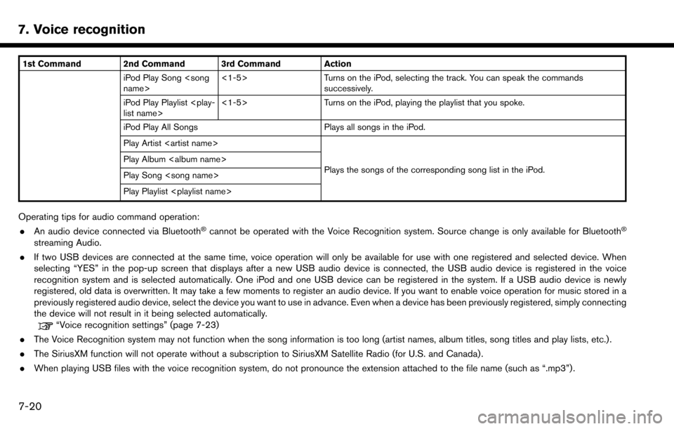
1st Command 2nd Command 3rd Command ActioniPod Play Song
successively.
iPod Play Playlist
iPod Play All Songs Plays all songs in the iPod.
Play Artist
Plays the songs of the corresponding song list in the iPod.
Play Album
Play Song
Play Playlist
Operating tips for audio command operation:
. An audio device connected via Bluetooth�Šcannot be operated with the Voice Recognition system. Source change is only available for Bluetooth�Š
streaming Audio.
. If two USB devices are connected at the same time, voice operation will only be available for use with one registered and selected device. When
selecting “YES” in the pop-up screen that displays after a new USB audio device is connected, the USB audio device is registered in the voice
recognition system and is selected automatically. One iPod and one USB device can be registered in the system. If a USB audio device is newly
registered, old data is overwritten. It may take a few moments to register an audio device. If you want to enable voice operation for music stored in a
previously registered audio device, select the device you want to use in advance. Even when a device has been previously registered, simply connecting
the device will not result in it being selected automatically.
“Voice recognition settings” (page 7-23)
. The Voice Recognition system may not function when the song information is too long (artist names, album titles, song titles and play lists, etc.) .
. The SiriusXM function will not operate without a subscription to SiriusXM Satellite Radio (for U.S. and Canada) .
. When playing USB files with the voice recognition system, do not pronounce the extension attached to the file name (such as “.mp3”) .
7-20