Page 81 of 90
 81
1
2
3
4
5
6
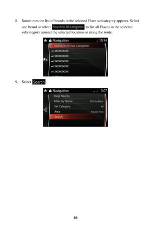
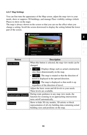
4.2.5 Map Settings
You can fine-tune the appearance of the Map screen, adjust the map view to your
needs, show or suppress 3D buildings, an d manage Place visibility settings (which
P")
81
1
2
3
4
5
6
4.2.5 Map Settings
You can fine-tune the appearance of the Map screen, adjust the map view to your
needs, show or suppress 3D buildings, an d manage Place visibility settings (which
Places to show on the map).
The map is always shown on the screen so that you can see the effect when you
change a setting. Scroll the screen downward to display the setting behind the lower
part of the screen.
ButtonDescription
When this button is selected, the map view mode can be
changed.
• : Displays things such as actual construction sites three dimensionally on the map.
• : The map is rotated so that the direction of travel is displayed in the upward direction.
• : The map is displayed so that north is up regardless of the direction of travel.
Adjust the basic zoom and tilt levels to your needs.
Three levels are available.
During route guidance in any map view mode, the
function for zooming in on approaching intersections
turns on/off automatically.
Show or hide 3D city models, 3D artistic or block
representation of all city buil ding data containing actual
building sizes and positions on the map.
Page 82 of 90
82
When enabled, the map zooms out to show an overview
of the surrounding area if the next route event
(maneuver) is far away. The system goes back to the
normal map view when you approach the next event.
Select which Places to show on the map while
navigating. Too many Places
make the map crowded, so
it is a good idea to show as few as possible. You have
the following possibilities:
• Select the checkbox to show or hide the Place category.
• Select the name of the Place category to open the list of its subcategories.
ButtonDescription
Page 83 of 90
83
1
2
3
4
5
6
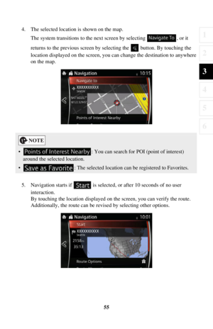
4.2.6 Visual Guidance settings
Adjust how the software helps you navigate with different kinds of route related
information on the Map screen.
ButtonDescription
Whenever adequate information is available, lane
information similar to the real ones on road signs
above the road is displayed at the top of the map. You
can turn this f eature on or off.
If you are approaching a highway/freeway exit or a
complex intersection and the needed information
exists, the map is replaced with a 3D view of the
junction. You can turn this feature on or let the map
be displayed for the whole route.
When entering tunnels, the surface roads and
buildings can be disturbing. This feature shows a
generic picture of a tunnel instead of the map. A top-
down overview of the tunnel and remaining distance
are also displayed.
Page 84 of 90
 84
5Glossary
Active route
The currently navigated route. Whenever a destination is set, the route is active until
you delete it or reach your destination. See also: Route.
City Center
The city center")
84
5Glossary
Active route
The currently navigated route. Whenever a destination is set, the route is active until
you delete it or reach your destination. See also: Route.
City Center
The city center is not the geometric center of the city but an arbitrary point the map
creators have chosen. In cities and villag es, it is usually the most important
intersection; in larger cities, it is one of the important intersections.
Color theme
The navigation system has different color themes for daytime and nighttime which
can be selected as desired.
One daytime scheme and one nighttime scheme is always selected for the map and
for the menus.
The navigation system uses them when it switches from day to night and back.
GPS accuracy
Several factors have impact on the devia tion between your real position and the one
given by the GPS device. For example, signal delay in the ionosphere or reflecting
objects near the GPS device have a different and varying impact on how accurately
the GPS device can calculate your position.
Page 85 of 90
 85
1
2
3
4
5
6
Map
The navigation system works with digital maps which are not simply the
computerized versions of traditional paper maps. Similarly to paper road maps, the
2D mode of digital maps s")
85
1
2
3
4
5
6
Map
The navigation system works with digital maps which are not simply the
computerized versions of traditional paper maps. Similarly to paper road maps, the
2D mode of digital maps show you streets, roads, and elevation by colors.
In 3D mode, you can see the altitude differences, for example valleys and mountains,
elevated roads, and in selected cities 3D landmarks and 3D buildings are also
displayed.
You can use digital maps interactively: you can zoom in and out (increase or
decrease the scale), you can tilt them up and down, and rotate them left and right. In
GPS-supported navigation, digital maps facilitate route planning.
North-up map orientation
In North-up mode the map is rotated so it s top always faces North. This is the
orientation for example in Find on Map.
Road Safety Camera
This function is not available in some countries and regions.
Special alert points for speed, red light or bus lane cameras. Different data sources
are available. You can configure the navigation system to warn you when you
approach one of these cameras.
Detecting the location of Road Safety Cameras is prohibited in certain countries. It is
the sole responsibility of the driver to ch eck whether this feature can be used during
the trip.
The software is capable of showing and wa rning for more than just cameras. Various
other types of proximity alert points like school zones and railway crossings are also
available.
Route
A sequence of maneuvers (for example, turns and roundabouts) to reach the
destination. The route contains one star t point and one or more destinations.
Track-up map orientation
In Track-up mode the map is rotated so its top always points in the current driving
direction. This is the default orientation in 3D map view mode.
Vehicle marker
The current position is indicated by a blue arrow on the map. The direction the blue
arrow is pointed indicat es the current heading.
Page 86 of 90
 86
6 End-User Terms
HERE END-USER TERMS
The data is provided for your personal, internal use only and not for resale. It is
protected by copyright, and is subject to the following terms and condition")
86
6 End-User Terms
HERE END-USER TERMS
The data is provided for your personal, internal use only and not for resale. It is
protected by copyright, and is subject to the following terms and conditions which
are agreed to by you, on the one hand, and VISTEON and its licensors (including
their licensors and suppliers) on the other hand.
© 2013 HERE. All rights reserved.
The Data for areas of Canada includes information taken with permission from
Canadian authorities, including: © Her Majesty the Queen in Right of Canada, ©
Queen’s Printer for Ontario, © Canada Post Corporation, GeoBase
®, © Department
of Natural Resources Canada.
HERE holds a non-exclusive license from the United States Postal Service
® to
publish and sell ZIP+4
® information. ©United States Postal Service® 2013. Prices
are not established, controlled or approv ed by the United States Postal Service
®. The
following trademarks and regi strations are owned by the USPS: United States Postal
Service, USPS, and ZIP+4.
The Data for Mexico includes certain data from Instituto Nacional de Estadística y
Geografía.
Terms and Conditions
Personal Use Only: You agree to use this Data together with VISTEON’s CMU for
the solely personal, non-commercial purposes for which you were licensed, and not
for service bureau, tim e-sharing or other similar purposes. Accordingly, but subject
to the restrictions set forth in the following paragraphs, you agree not to otherwise
reproduce, copy, modify, d ecompile, disassemble, create any derivative works of, or
reverse engineer any portion of this Data, an d may not transfer or distribute it in any
form, for any purpose, except to the extent permitted by mandatory laws.
Restrictions
: Except where you have been specifically licensed to do so by VISTEON,
and without limiting the preceding paragraph, you may not (a) use this Data with any
products, systems, or applications installed or otherwise connected to or in
communication with vehicles, capable of vehi cle navigation, positioning, dispatch, real
time route guidance, fleet management or similar applications; or (b) with or in
communication with any positioning devices or any mobile or wireless-connected
electronic or computer devices, including without limitation cellular phones, palmtop
and handheld computers, pagers, and personal digital assistants or PDAs.
Page 87 of 90
 87
1
2
3
4
5
6
Warning: The Data may contain inaccurate or incomplete information due to the
passage of time, changing circumstances, s ources used and the nature of collecting
comprehensive geograp")
87
1
2
3
4
5
6
Warning: The Data may contain inaccurate or incomplete information due to the
passage of time, changing circumstances, s ources used and the nature of collecting
comprehensive geographic data, any of which may lead to incorrect results.
No Warranty
. This Data is provided to you “as is,” and you agree to use it at your
own risk. VISTEON and its licensors (and their licensors and suppliers) make no
guarantees, representations or warranties of any kind, express or implied, arising by
law or otherwise, including but not limited to, content, quality, accuracy,
completeness, effectiveness, reliability, fitness for a particular purpose, usefulness,
use or results to be obtained from this Da ta, or that the Data or server will be
uninterrupted or error-free.
Disclaimer of Warranty
: VISTEON AND ITS LICE NSORS (INCLUDING THEIR
LICENSORS AND SUPPLIERS) DISC LAIM ANY WARRANTIES, EXPRESS
OR IMPLIED, OF QUALITY, PERF ORMANCE, MERCHANTABILITY, And
FITNESS FOR A PARTICULAR PURPOSE OR NON-INFRINGEMENT. Some
States, Territories and Countries do not allow certain warranty exclusions, so to that
extent the above exclusion may not apply to you.
Disclaimer of Liability
: VISTEON AND ITS LICENSORS (INCLUDING THEIR
LICENSORS AND SUPPLIERS) SHALL NOT BE LIABLE TO YOU: IN
RESPECT OF ANY CLAIM, DEMAND OR ACTION, IRRESPECTIVE OF THE
NATURE OF THE CAUSE OF THE CLAIM, DEMAND OR ACTION
ALLEGING ANY LOSS, INJURY OR DA MAGES, DIRECT OR INDIRECT,
WHICH MAY RESULT FROM THE USE OR POSSESSION OF THE
INFORMATION; OR FOR ANY LOSS OF PROFIT, REVENUE, CONTRACTS
OR SAVINGS, OR ANY OTHER DIRECT, INDIRECT, INCIDENTAL, SPECIAL
OR CONSEQUENTIAL DAMAGES ARISING OUT OF YOUR USE OF OR
INABILITY TO USE THIS INFORMATION, ANY DEFECT IN THE
INFORMATION, OR THE BREACH OF THESE TERMS OR CONDITIONS,
WHETHER IN AN ACTION IN CONTRACT OR TORT OR BASED ON A
WARRANTY, EVEN IF VISTEON OR ITS LICENSORS HAVE BEEN
ADVISED OF THE POSSIBILITY OF SUCH DAMAGES. Some States,
Territories and Countries do not allow certain liability exclusions or damages
limitations, so to that extent the above may not apply to you.
Page 88 of 90
 88
Export Control
: VISTEON shall not export from anywhere any part of the Data or
any direct product thereof except in co mpliance with, and with all licenses and
approvals required under, applicab")
88
Export Control
: VISTEON shall not export from anywhere any part of the Data or
any direct product thereof except in co mpliance with, and with all licenses and
approvals required under, applicable export laws, rules and regulations, including but
not limited to the laws, rules and regulation s administered by the Office of Foreign
Assets Control of the U.S. Department of Commerce and the Bureau of Industry and
Security of the U.S. Department of Comm erce. To the extent that any such export
laws, rules or regulations prohibit HERE from complying with any of its obligations
hereunder to deliver or distribute Data, such failure shall be excused and shall not
constitute a breach of this Agreement.
Entire Agreement
: These terms and conditions cons titute the entire agreement
between VISTEON (and its licensors, incl uding their licensors and suppliers) and
you pertaining to the subject matter hereof, and supersedes in their entirety any and
all written or oral agreements previously existing between us with respect to such
subject matter.
Governing Law
: The above terms and conditions sh all be governed by the laws of
the State of Illinois [“Nether lands” where European HERE Data is used], without
giving effect to (i) its conflict of law’s provisions, or (ii) the United Nations
Convention for Contracts for the International Sale of Goods, which is explicitly
excluded. You agree to submit to the juri sdiction of the State of Illinois [“The
Netherlands” where European HERE Data is used] for any and all disputes, claims
and actions arising from or in connection with the Data provided to you hereunder.
Government End Users
: If the Data is being acquired by or on behalf of the United
States government or any other entity seeking or applying rights similar to those
customarily claimed by the United States government, this Data is a “commercial
item” as that term is defined at 48 C.F. R. (“FAR”) 2.101, is licensed in accordance
with these End-User Terms, and each copy of Data delivered or otherwise furnished
shall be marked and embedded as appropri ate with the following “Notice of Use,”
and shall be treated in acc ordance with such Notice:


 82
When enabled, the map zooms out to show an overview
of the surrounding area if the next route event
(maneuver) is far away. The system goes back to the
normal map view when you approach the next")
 83
1
2
3
4
5
6
4.2.6 Visual Guidance settings
Adjust how the software helps you navigate with different kinds of route related
information on the Map screen.
ButtonDescription
Whenever adequate infor")