Page 16 of 90

16
2.4.3.3 Lane information and Signposts
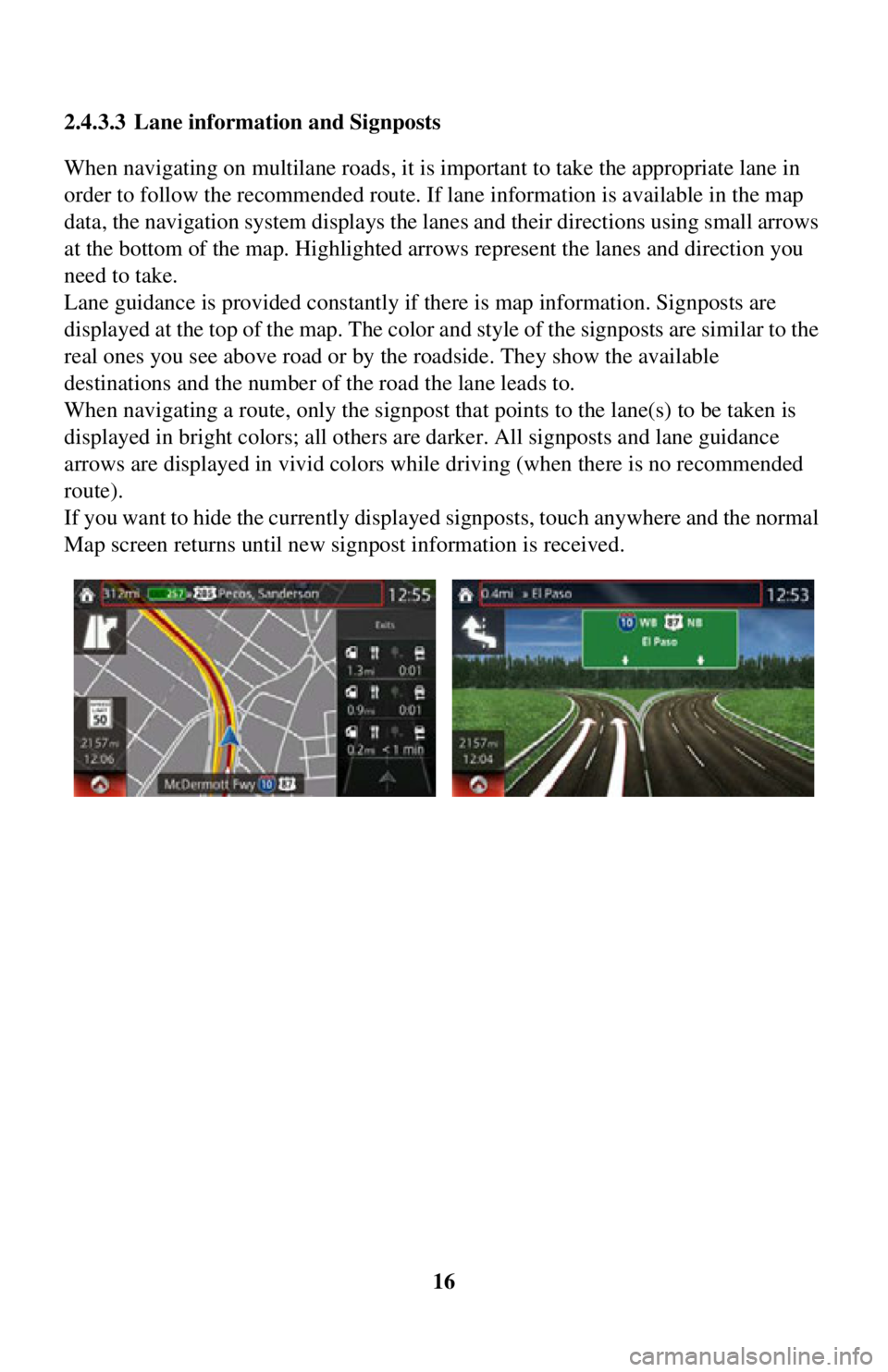
When navigating on multilane roads, it is im
portant to take the appropriate lane in
order to follow the recommended route. If lane information is available in the map
data, the navigation system displays the lanes and their directions using small arrows
at the bottom of the map. Highlighted ar rows represent the lanes and direction you
need to take.
Lane guidance is provided constantly if there is map information. Signposts are
displayed at the top of the map. The color and style of the signposts are similar to the
real ones you see above road or by the roadside. They show the available
destinations and the number of the road the lane leads to.
When navigating a route, only the signpost that points to the lane(s) to be taken is
displayed in bright colors; all others are darker. All signposts and lane guidance
arrows are displayed in vivid colors while driving (when there is no recommended
route).
If you want to hide the currently displa yed signposts, touch anywhere and the normal
Map screen returns until new signpost information is received.
Page 74 of 90

74
4.1.3 Road safety cameras and other proximity alert points (Only some
countries and regions)
There is a special proximity warning for road safety camer as (like speed or red light
cameras) and other proximity alert points (like schools or railroad crossings).
The application can warn you when you a pproach road safety cameras like speed
cameras or dangerous areas li ke school zones or railroad crossings. You can set up
the different alert type s individually in Warning Settings (page 78).
The following alert types are available:
• Audio warning: When appr oaching one of these points, a beep sound (regular
sound) can be used or the type of warning can be announced (TTS), and an extra
alert can warn you if you exceed the given speed limit while approaching the point.
• Always: The type of the alert point, its distance, and the related speed limit appear
on the Map screen while you are approaching one of these points.
For some of the alert points, the enforced or expected speed limit is available. For
these points, the audio alert can be diff erent if you are below or above the given
speed limit.
Setting can be selected using Warning Settings:
• Only when speeding: The audio alert is only played when you exceed the given
speed limit.
• When approaching: The audio alert is always played when approaching one of these alert points. To draw you attentio n, the alert may differ if you exceed the
speed limit.
The warning for road safety cameras is di sabled when you are in a country where
road safety camera warning is prohibited. However, you must ensure on your own
liability that using this feature is legal in the country where you intend to use it.
Page 85 of 90

85
1
2
3
4
5
6
Map
The navigation system works with digital maps which are not simply the
computerized versions of traditional paper maps. Similarly to paper road maps, the
2D mode of digital maps show you streets, roads, and elevation by colors.
In 3D mode, you can see the altitude differences, for example valleys and mountains,
elevated roads, and in selected cities 3D landmarks and 3D buildings are also
displayed.
You can use digital maps interactively: you can zoom in and out (increase or
decrease the scale), you can tilt them up and down, and rotate them left and right. In
GPS-supported navigation, digital maps facilitate route planning.
North-up map orientation
In North-up mode the map is rotated so it s top always faces North. This is the
orientation for example in Find on Map.
Road Safety Camera
This function is not available in some countries and regions.
Special alert points for speed, red light or bus lane cameras. Different data sources
are available. You can configure the navigation system to warn you when you
approach one of these cameras.
Detecting the location of Road Safety Cameras is prohibited in certain countries. It is
the sole responsibility of the driver to ch eck whether this feature can be used during
the trip.
The software is capable of showing and wa rning for more than just cameras. Various
other types of proximity alert points like school zones and railway crossings are also
available.
Route
A sequence of maneuvers (for example, turns and roundabouts) to reach the
destination. The route contains one star t point and one or more destinations.
Track-up map orientation
In Track-up mode the map is rotated so its top always points in the current driving
direction. This is the default orientation in 3D map view mode.
Vehicle marker
The current position is indicated by a blue arrow on the map. The direction the blue
arrow is pointed indicat es the current heading.