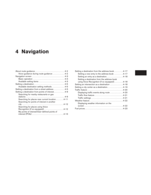
Page 25 of 80
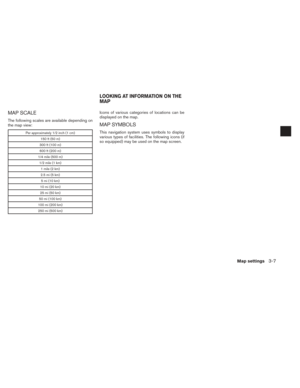
MAP SCALE
The following scales are available depending on
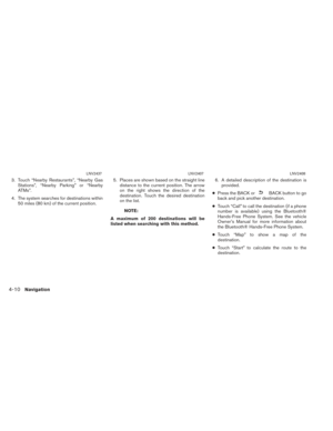
the map view:
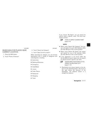
Per approximately 1/2 inch (1 cm)150 ft (50 m)
300 ft (100 m)
600 ft (200 m)
1/4 mile (500 m) 1/2 mile (1 km) 1 mile (2 km)
2.5 mi (5 km) 5 mi (10 km)
10 mi (20 km)
25 mi (50 km)
50 mi (100 km)
100 mi (200 km)
250 mi (500 km)
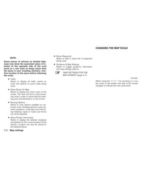
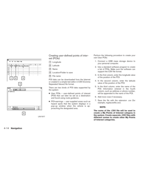
Icons of various categories of locations can be
displayed on the map.
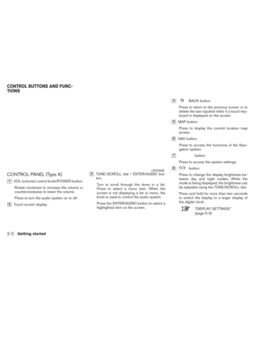
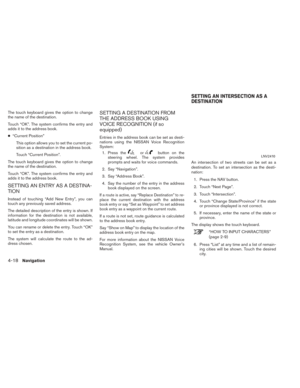
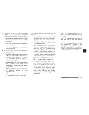
MAP SYMBOLS
This navigation system uses symbols to display
various types of facilities. The following icons (if
so equipped) may be used on the map screen.
LOOKING AT INFORMATION ON THE
MAP
Map settings3-7
Page 26 of 80
Page 27 of 80

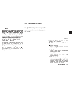
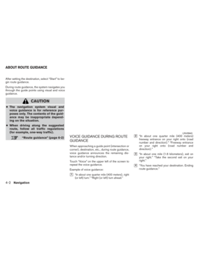
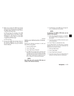
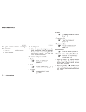
Other settings are available for the map screen,
such as switching the map view or changing the
map direction.1. Press the
or MENU button.
2. Touch the “Settings” key. 3. Touch the “Navigation” key.
4. Touch the “Guidance & Map Settings” key.
When selected, the system will offer the fol-
lowing map setting options:
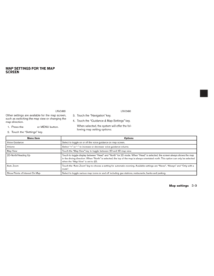
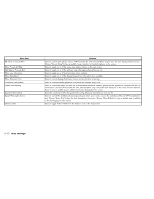
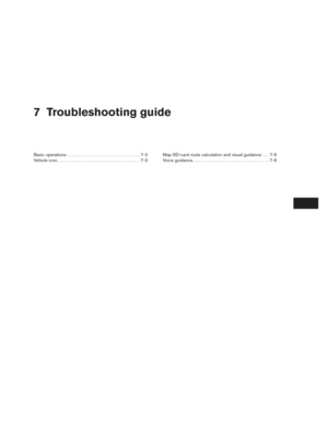
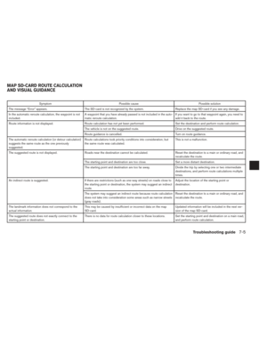
Menu Item Options
Voice Guidance Select to toggle on or off the voice guidance on map screen.
Volume Select “+” or “-” to increase or decrease voice guidance volume.
Map View Touch the “Map View” key to toggle between 2D and 3D map view.
2D-North/Heading Up Touch to toggle display between “Head” and “North” for 2D mode. When “Head” is selected, the screen always shows the map
in the driving direction. When “North” is selected, the top of the map is always orientated north. This option can only be selected
when the “Map View” is set to 2D.
Auto Zoom Touch the “Auto Zoom” key to choose a setting for automatic zooming. Available settings are “Never”, “Always” and “Only with a
route”.
Show Points of Interest On Map Select to toggle various map icons on and off including gas stations, restaurants, banks and parking.
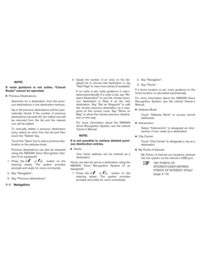
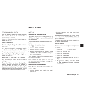
LNV2490LNV2460
MAP SETTINGS FOR THE MAP
SCREEN
Map settings3-9
Page 28 of 80

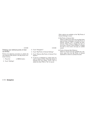
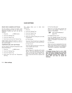
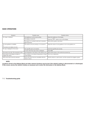
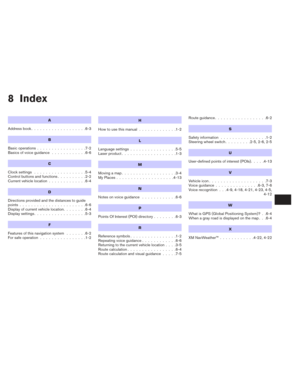
Menu ItemOptions
My Points of Interest Alert Select to control alert options. Choose “Off” to disable the alert. Choose “Show Only” to have the alert displayed on the screen.
Choose “Show & Beep” to have an audible beep in addition to the alert displayed on the screen.
Show Presets On Map Select to toggle on or off the preset radio station buttons on the map screen.
Split Map for Freeway Exit Select to toggle on or off the split view map when approaching a freeway exit.
Show Lane Information Select to toggle on or off lane information when available.
Show Speed Limit Select to toggle on or off the display of speed limit information when available.
Show Estimated Time Select to control display of estimated time of arrival or trip time remaining.
Customize Travel Speed Select to customize travel speeds on local roads and freeways along route.
Speed Limit Warning Select to control the speed limit alert that activates when the vehicle speed is greater than the speed limit information for the cu r-
rent location. Choose “Off” to disable the alert. Choose “Show Only” to have the alert displayed on the screen. Choose “Show &
Beep” to have an audible beep in addition to the alert displayed on the screen.
Speed Limit Sensitivity Select the sensitivity level for the speed limit warning. Choose a value between zero and 30
Speed Warning for Curves Select to control the alert that activates depending on vehicle speed and a curve in the road ahead. Choose “Off” to disable the
alert. Choose “Show Only” to have the alert displayed on the screen. Choose “Show & Beep” to have an audible beep in addition
to the alert displayed on the screen.
Distance Units Select to toggle “US” or “Metric” for the distance units on the map screen.
3-10Map settings
Page 29 of 80

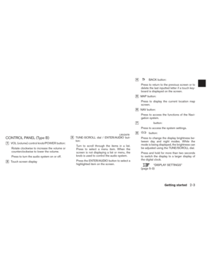
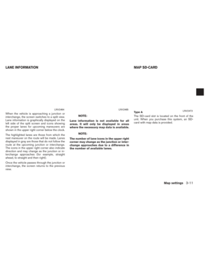
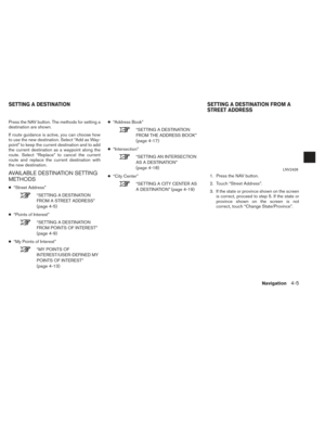
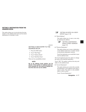
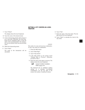
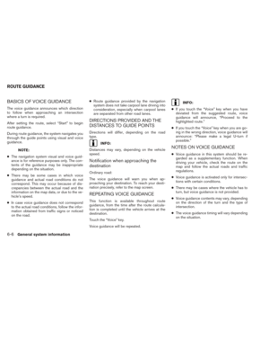
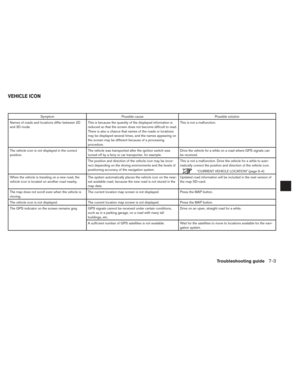
When the vehicle is approaching a junction or
interchange, the screen switches to a split view.
Lane information is graphically displayed on the
left side of the split screen and icons showing
the proper lanes for upcoming maneuvers are
shown in the upper right corner below the clock.
The highlighted lanes are those from which the
next maneuver on the route will be made. Lanes
displayed in gray are those that do not follow the
route at the upcoming junction or interchange.
The icons in the upper right corner also indicate
direction and may change as the junction or in-
terchange approaches (for example, straight
ahead, to straight and then right) .
Once the vehicle passes through the junction or
interchange, the screen returns to the previous
view.NOTE:
Lane information is not available for all
areas. It will only be displayed in areas
where the necessary map data is available.
NOTE:
The number of lane icons in the upper right
corner may change as the junction or inter-
change approaches due to a difference in
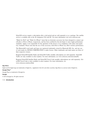
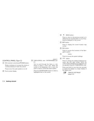
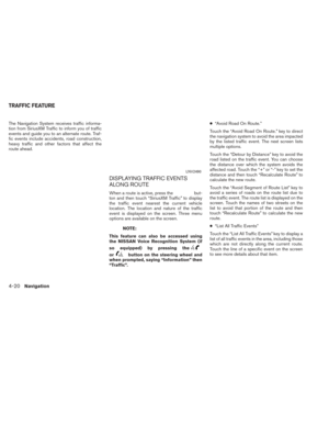
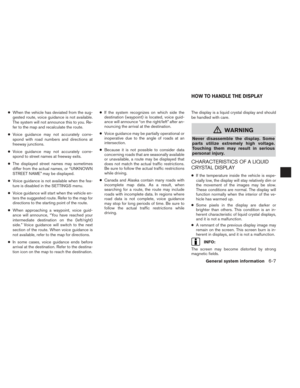
the number of available lanes. The SD-card slot is located on the front of the
unit. When you purchase this system, an SD-
card with map data is provided.
LNV2464LNV2465Ty p e ALNV2473
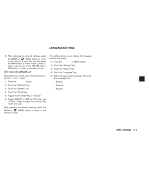
LANE INFORMATION
MAP SD-CARD
Map settings3-11
Page 30 of 80

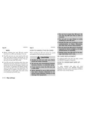
NOTE:
● Before inserting the map SD-card confirm
that there is no SD-card already in the slot.
● The SD-card slot can only read the SD-card
with map data provided specifically for use
with the vehicle’s navigation system. The sys-
tem will not read other SD-cards.
● If an SD-card with something other than map
data (such as music, pictures or movies) is in-
serted into the slot, the Navigation System will
not function. A message will appear prompt-
ing for the map SD-card to be reinserted. This
message will not appear if the SD-card is re-
moved while in audio mode. The audio mode
is not affected by the SD-card.HOW TO HANDLE THE SD-CARD
When handling the SD-card, please be careful
and adhere to the following instructions:
CAUTION
● Handle the SD-card with care. Never
touch the metal contacts.
● Do not use any conventional cleaner,
benzine, thinner, or antistatic spray.
● If you need to clean the SD-card use
a soft cloth.
● Never attempt to use an SD-card that
has been cracked, deformed or re-
paired using adhesive. Doing so may
damage the equipment. ●
Do not try to bend the SD-card. Do
not use any SD-card that is bent or
cracked.
● Do not put on any sticker or write
anything on the SD card.
● Handle the SD-card carefully to avoid
contamination or flaws. Otherwise,
the data may not be read properly.
● Do not store the SD-card in locations
exposed to direct sunlight, or in high
temperatures or humidity.
● Always place the SD-card in its stor-
age case when not in use.
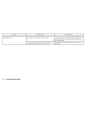
SD-CARD REPLACEMENT
For additional SD-cards with map data, contact
the NISSAN Navigation Helpdesk.
HOW TO ORDER MAP DATA UP-
DATES
To order updated map data and voice
commands, contact the NISSAN Navigation
Helpdesk. See the contact information on the in-
side front cover of this manual.
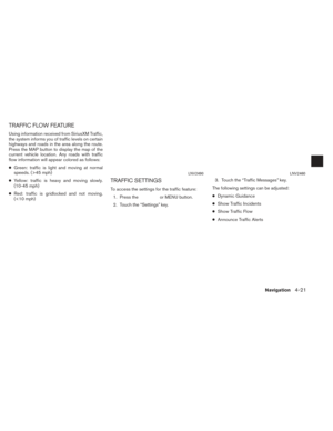
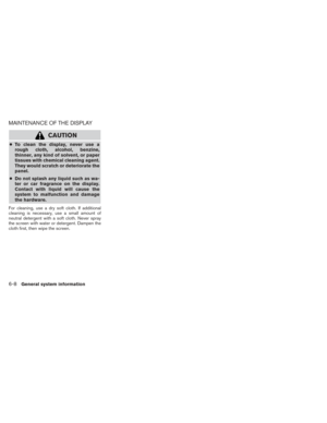
Ty p e BLNV2474Type CLNV2475
3-12Map settings
Page 31 of 80

ABOUT THE MAP DATA
●Bosch has compiled the digitized map data
into a usable format. © 2011 Robert Bosch
GmbH all rights in compilation software
reserved. Due to the production timing of the
map data, some new roads may not be
included, or some names and roads may be
different from those in use at the time this map
data is used.
● Traffic control and regulation data used in this
map data may be different from those in use at
the time this map data is used. When driving,
follow the actual traffic control signs and no-
tices on the roads.
● Reproducing or copying this map software is
strictly prohibited by law.mWARNING
● This navigation system should not be
used to replace your own judgement.
No itinerary suggested by this navi-
gation system should ever override
any freeway regulations, your own
judgement, or a knowledge of safe
driving practices. Do not follow the
navigation system’s suggested itin-
erary if it would cause you to perform
a dangerous or illegal act, place you
in a dangerous situation, or take you
into an area you consider unsafe.
● The advice provided by the naviga-
tion system is to be regarded as a
suggestion only. There may be times
when the navigation system displays
the vehicle’s location incorrectly,
fails to suggest the shortest route, or
fails to direct you to your desired
destination. In such instances, rely
on your own judgement taking into
account the driving conditions at the
time. ●
Do not use the navigation system to
locate emergency services. The data-
base does not contain a complete
listing of emergency services such as
police stations, fire stations, hospi-
tals and walk-in clinics. Please show
discretion and ask for directions in
such instances.
● As the driver, you alone are respon-
sible for your driving safety.
– In order to avoid a traffic accident, do not operate the system while
driving.
– In order to avoid a traffic accident, operate the system only when the
vehicle is stopped at a safe place
and the parking brake is on.
– In order to avoid a traffic accident or traffic offence, remember that
actual road conditions and traffic
regulations take precedence over
the information contained on the
navigation system.
Map settings
3-13
Page 32 of 80

– The software may contain inaccu-rate or incomplete information
due to the passage of time, chang-
ing circumstances, and the
sources of information used.
Please respect current traffic con-
ditions and regulations at all
times while driving.
– Where actual road conditions and highway regulations differ from
the information contained on the
navigation system, abide by the
highway regulations.
– Keep the amount of time spent viewing the screen while driving to
a strict minimum.
The navigation system does not provide, nor rep-
resent in any way information on: traffic and
highway regulations; technical aspects of the ve-
hicle including weight, height, width, load and
speed limits; road conditions including grade,
percentage of incline and surface conditions;
obstacles such as the height and width of
bridges and tunnels; and other current driving or
road conditions. Always rely on your own judge-
ment when driving a car, taking into account cur-
rent driving conditions. The company trademarks used in this product to
identify locations and business offices are the
trademarks of their respective owners. Their use
does not represent sponsorship, approval or
recommendation of this product by these
companies.
END-USER TERMS
The data (“Data”) is provided for your personal,
internal use only and not for resale. It is pro-
tected by copyright, and is subject to the follow-
ing terms and conditions which are agreed to by
you, on the one hand, and NISSAN and its licen-
sors (including their licensors and suppliers) on
the other hand.
© 2011 NAVTEQ. All rights reserved.
The Data for areas of Canada includes informa-
tion taken with permission from Canadian
authorities, including: © Her Majesty the Queen
in Right of Canada, © Queen’s Printer for
Ontario, © Canada Post Corporation,
GeoBase®, © Department of Natural Re-
sources Canada.
NAVTEQ holds a non-exclusive license from the
United States Postal Service® to publish and
sell ZIP+4® information.
©United States Postal Service® 2009. Prices
are not established, controlled or approved by
the United States Postal Service®. The follow-ing trademarks and registrations are owned by
the USPS: United States Postal Service, USPS,
and ZIP+4.
The Data may include or reflect data of licensors,
including Her Majesty the Queen in the Right of
Canada (“Her Majesty”) , Canada Post
Corporation (“Canada Post”) and the Depart-
ment of Natural Resources Canada (“NRCan”) .
Such data is licensed on an “as is” basis. The
licensors, including Her Majesty, Canada Post
and NRCan, make no guarantees, representa-
tions or warranties respecting such data, either
express or implied, arising by law or otherwise,
including but not limited to, effectiveness,
completeness, accuracy or fitness for a particu-
lar purpose.
The licensors, including Her Majesty, Canada
Post and NRCan, shall not be liable in respect of
any claim, demand or action, irrespective of the
nature of the cause of the claim, demand or ac-
tion alleging any loss, injury or damages, direct
or indirect, which may result from the use or pos-
session of the data or the Data. The licensors, in-
cluding Her Majesty, Canada Post and NRCan,
shall not be liable in any way for loss of revenues
or contracts, or any other consequential loss of
any kind resulting from any defect in the data or
the Data.
3-14Map settings


150 ft (50 m)
300 ft (100 m)
600 ft (200 m)
1/4 mile (500 m) 1/2 mile (1 km) 1 mile (2 km)
2.5")
