2014 MITSUBISHI MIRAGE lock
[x] Cancel search: lockPage 3 of 135

3
12. SOURCE OPERATIONS ..................................................................................................................................................................105
Radio Operations ..............................................................................................................................................................................105
DVD Video Operations ......................................................................................................................................................................106
Audio CD Operations ........................................................................................................................................................................111
MP3/WMA/AAC Disc Operations ......................................................................................................................................................112
SD Memory Card/USB Memory Operations .....................................................................................................................................115
iPod Operations ................................................................................................................................................................................117
Bluetooth Audio Operations ..............................................................................................................................................................120
13. TELEPHONE OPERATIONS ...........................................................................................................................................................122
Using your Bluetooth Mobile Phone with this Unit ............................................................................................................................122
14. SYSTEM SETTINGS ........................................................................................................................................................................125
Audio Settings ...................................................................................................................................................................................125
Display Adjustment ...........................................................................................................................................................................126
Volume and Beeps Settings ..............................................................................................................................................................126
Selecting a Language .......................................................................................................................................................................126
Phone Settings .................................................................................................................................................................................126
Bluetooth Settings .............................................................................................................................................................................129
Clock Settings ...................................................................................................................................................................................130
Other Settings ...................................................................................................................................................................................130
15. TROUBLESHOOTING......................................................................................................................................................................131
205-0010-00_QY-7375M-A_EN.indb 3205-0010-00_QY-7375M-A_EN.indb 33/12/2013 9:57:13 AM3/12/2013 9:57:13 AM
Page 17 of 135
17
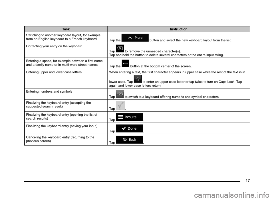
Task Instruction
Switching to another keyboard layout, for example
from an English keyboard to a French keyboard
Tap the
button and select the new keyboard layout from the list.
Correcting your entry on the keyboard
Tap
to remove the unneeded character(s).
Tap and hold the button to delete several characters or the entire input string.
Entering a space, for example between a first name
and a family name or in multi-word street names
Tap the
button at the bottom center of the screen.
Entering upper and lower case letters When entering a text, the first character appears in upper case while the rest of the text is in
lower case. Tap
to enter an upper case letter or tap twice to turn on Caps Lock. Tap
again and lower case letters return.
Entering numbers and symbols
Tap
to switch to a keyboard offering numeric and symbol characters.
Finalizing the keyboard entry (accepting the
suggested search result)
Tap
.
Finalizing the keyboard entry (opening the list of
search results)
Tap
.
Finalizing the keyboard entry (saving your input)
Tap
.
Canceling the keyboard entry (returning to the
previous screen)
Tap
.
205-0010-00_QY-7375M-A_EN.indb 17205-0010-00_QY-7375M-A_EN.indb 173/12/2013 9:57:14 AM3/12/2013 9:57:14 AM
Page 20 of 135
20
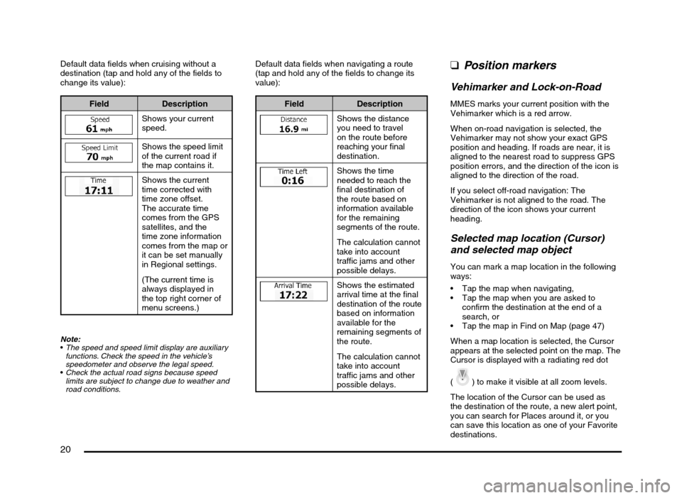
Default data fields when cruising without a
destination (tap and hold any of the fields to
change its value):
Field Description
Shows your current
speed.
Shows the speed limit
of the current road if
the map contains it.
Shows the current
time corrected with
time zone offset.
The accurate time
comes from the GPS
satellites, and the
time zone information
comes from the map or
it can be set manually
in Regional settings.
(The current time is
always displayed in
the top right corner of
menu screens.)
Note:
The speed and speed limit display are auxiliary
functions. Check the speed in the vehicle’s
speedometer and observe the legal speed.
Check the actual road signs because speed
limits are subject to change due to weather and
road conditions.
Default data fields when navigating a route
(tap and hold any of the fields to change its
value):
Field Description
Shows the distance
you need to travel
on the route before
reaching your final
destination.
Shows the time
needed to reach the
final destination of
the route based on
information available
for the remaining
segments of the route.
The calculation cannot
take into account
traffic jams and other
possible delays.
Shows the estimated
arrival time at the final
destination of the route
based on information
available for the
remaining segments of
the route.
The calculation cannot
take into account
traffic jams and other
possible delays.
qPosition markers
Vehimarker and Lock-on-Road
MMES marks your current position with the
Vehimarker which is a red arrow.
When on-road navigation is selected, the
Vehimarker may not show your exact GPS
position and heading. If roads are near, it is
aligned to the nearest road to suppress GPS
position errors, and the direction of the icon is
aligned to the direction of the road.
If you select off-road navigation: The
Vehimarker is not aligned to the road. The
direction of the icon shows your current
heading.
Selected map location (Cursor)
and selected map object
You can mark a map location in the following
ways:
Tap the map when navigating,
Tap the map when you are asked to
confirm the destination at the end of a
search, or
Tap the map in Find on Map (page 47)
When a map location is selected, the Cursor
appears at the selected point on the map. The
Cursor is displayed with a radiating red dot
(
) to make it visible at all zoom levels.
The location of the Cursor can be used as
the destination of the route, a new alert point,
you can search for Places around it, or you
can save this location as one of your Favorite
destinations.
205-0010-00_QY-7375M-A_EN.indb 20205-0010-00_QY-7375M-A_EN.indb 203/12/2013 9:57:15 AM3/12/2013 9:57:15 AM
Page 23 of 135
23
3D object types
MMES supports the following 3D object types:
Type Description
3D terrain 3D terrain map data shows changes in terrain, elevations or depressions in the land when you view the map in 2D, and
use it to plot the route map in 3D when you navigate. Hills and mountains are shown in the background of the 3D map, and
illustrated by color and shading on the 2D map.
Elevated roads Complex intersections and vertically isolated roads (such as overpasses or bridges) are displayed in 3D.
3D landmarks Landmarks are 3D artistic or block representations of prominent or well-known objects.
Elements of the active route
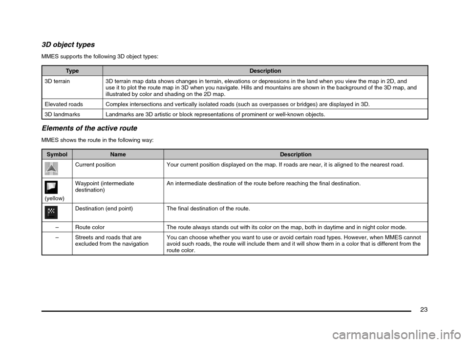
MMES shows the route in the following way:
Symbol Name Description
Current position Your current position displayed on the map. If roads are near, it is aligned to the nearest road.
(yellow)Waypoint (intermediate
destination)An intermediate destination of the route before reaching the final destination.
Destination (end point) The final destination of the route.
– Route color The route always stands out with its color on the map, both in daytime and in night color mode.
– Streets and roads that are
excluded from the navigationYou can choose whether you want to use or avoid certain road types. However, when MMES cannot
avoid such roads, the route will include them and it will show them in a color that is different from the
route color.
205-0010-00_QY-7375M-A_EN.indb 23205-0010-00_QY-7375M-A_EN.indb 233/12/2013 9:57:15 AM3/12/2013 9:57:15 AM
Page 24 of 135
24
qManipulating the map
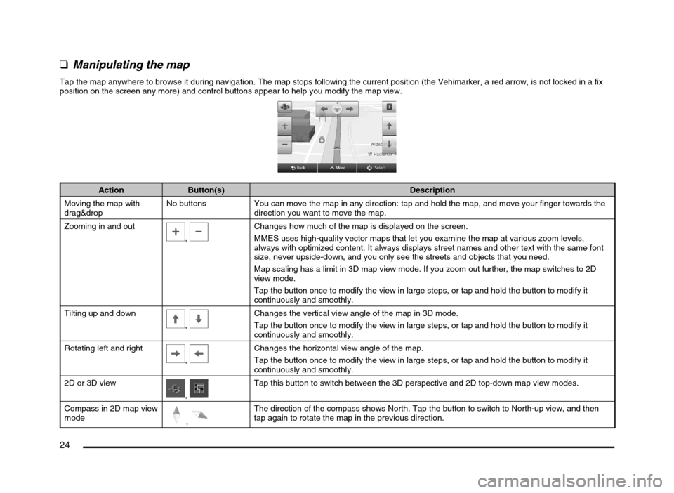
Tap the map anywhere to browse it during navigation. The map stops following the current position (the Vehimarker, a red arrow, is not locked in a fix
position on the screen any more) and control buttons appear to help you modify the map view.
Action Button(s) Description
Moving the map with
drag&dropNo buttons You can move the map in any direction: tap and hold the map, and move your finger towards the
direction you want to move the map.
Zooming in and out
, Changes how much of the map is displayed on the screen.
MMES uses high-quality vector maps that let you examine the map at various zoom levels,
always with optimized content. It always displays street names and other text with the same font
size, never upside-down, and you only see the streets and objects that you need.
Map scaling has a limit in 3D map view mode. If you zoom out further, the map switches to 2D
view mode.
Tap the button once to modify the view in large steps, or tap and hold the button to modify it
continuously and smoothly.
Tilting up and down
,
Changes the vertical view angle of the map in 3D mode.
Tap the button once to modify the view in large steps, or tap and hold the button to modify it
continuously and smoothly.
Rotating left and right
,
Changes the horizontal view angle of the map.
Tap the button once to modify the view in large steps, or tap and hold the button to modify it
continuously and smoothly.
2D or 3D view
, Tap this button to switch between the 3D perspective and 2D top-down map view modes.
Compass in 2D map view
mode
,
The direction of the compass shows North. Tap the button to switch to North-up view, and then
tap again to rotate the map in the previous direction.
205-0010-00_QY-7375M-A_EN.indb 24205-0010-00_QY-7375M-A_EN.indb 243/12/2013 9:57:15 AM3/12/2013 9:57:15 AM
Page 70 of 135
70
q
Map settings
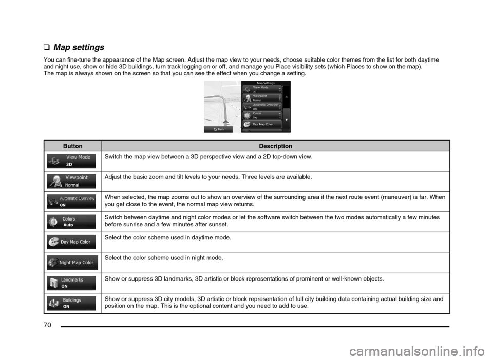
You can fine-tune the appearance of the Map screen. Adjust the map view to your needs, choose suitable color themes from the list for both daytime
and night use, show or hide 3D buildings, turn track logging on or off, and manage you Place visibility sets (which Places to show on the map).
The map is always shown on the screen so that you can see the effect when you change a setting.
Button Description
Switch the map view between a 3D perspective view and a 2D top-down view.
Adjust the basic zoom and tilt levels to your needs. Three levels are available.
When selected, the map zooms out to show an overview of the surrounding area if the next route event (maneuver) is far. When
you get close to the event, the normal map view returns.
Switch between daytime and night color modes or let the software switch between the two modes automatically a few minutes
before sunrise and a few minutes after sunset.
Select the color scheme used in daytime mode.
Select the color scheme used in night mode.
Show or suppress 3D landmarks, 3D artistic or block representations of prominent or well-known objects.
Show or suppress 3D city models, 3D artistic or block representation of full city building data containing actual building size and
position on the map. This is the optional content and you need to add to use.
205-0010-00_QY-7375M-A_EN.indb 70205-0010-00_QY-7375M-A_EN.indb 703/12/2013 9:57:24 AM3/12/2013 9:57:24 AM
Page 77 of 135

77
6. GLOSSARY
2D/3D GPS reception
The GPS receiver uses satellite signals to
calculate its (your) position and needs at
least four signals to give a three-dimensional
position, including elevation. Because the
satellites are moving and because objects
can block the signals, your GPS device might
not receive four signals. If three satellites
are available, the receiver can calculate the
horizontal GPS position but the accuracy is
lower and the GPS device does not give you
elevation data: only 2D reception is possible.
Active route
The currently navigated route. Whenever the
destination is set, the route is active until you
delete it, reach your destination or you quit
MMES. See also: Route.
City Center
The city/town center is not the geometric
center of the city/town but an arbitrary point
the map creators have chosen. In towns
and villages, it is usually the most important
intersection; in larger cities, it is one of the
important intersections.
Color theme
MMES comes with different color themes for
daytime or night use of the map and menu
screens. Themes are custom graphic settings
and they can have different colors for streets,
blocks or surface waters in 2D and 3D modes,
and they display shades or shadows in
different ways in 3D mode.
One daytime scheme and one night scheme
is always selected for the map and for the
menus. MMES uses them when it switches
from day to night and back.
GPS accuracy
Several factors have impact on the deviation
between your real position and the one given
by the GPS device. For example, signal delay
in the ionosphere or reflecting objects near
the GPS device have a different and varying
impact on how accurately the GPS device can
calculate your position.
Map
MMES works with digital maps which are not
simply the computerized versions of traditional
paper maps. Similarly to the paper road maps,
the 2D mode of digital maps show you streets,
roads, and elevation is also shown by colors.
In 3D mode, you can see the altitude
differences, for example valleys and
mountains, elevated roads, and in selected
cities 3D landmarks and 3D buildings are also
displayed.You can use digital maps interactively: you
can zoom in and out (increase or decrease
the scale), you can tilt them up and down, and
rotate them left and right. In GPS-supported
navigation, digital maps facilitate route
planning.
North-up map orientation
In North-up mode the map is rotated so its top
always faces North. This is the orientation for
example in Find on Map.
Road Safety Camera
Special alert points for speed, red light or
bus lane cameras. Different data sources
are available. You can configure MMES to
warn you when you approach one of these
cameras.
Detecting the location of Road Safety Cameras
is prohibited in certain countries. It is the sole
responsibility of the driver to check whether
this feature can be used during the trip.
The software is capable of showing and
warning for more than just cameras. Various
other types of proximity alert points like
school zones and railroad crossings are also
available.
Route
A sequence of route events, i.e. maneuvers
(for example, turns and traffic circles) to reach
the destination. The route contains one start
point and one or more destinations. The start
point is the current position by default. If you
need to see a future route, the start point can
be replaced with any other given point.
205-0010-00_QY-7375M-A_EN.indb 77205-0010-00_QY-7375M-A_EN.indb 773/12/2013 9:57:25 AM3/12/2013 9:57:25 AM
Page 95 of 135

95
Main menu operation
(Navigation screen)
(Bluetooth Phone)
(General settings) Switching between
day and night modes.Turning the
Monitor Display Off
and displaying the
Clock screen.
205-0010-00_QY-7375M-A_EN.indb 95205-0010-00_QY-7375M-A_EN.indb 953/12/2013 9:57:26 AM3/12/2013 9:57:26 AM