Page 65 of 210

Dep
endingonthe point ofinte rest
se lected ,CO MAND uses diffe rent
ref ere nce points inde term ining the linea r
di sta nce tothe destinati on:
R vicini tyof cur rent positio n:the linea r
di sta nce isthe dista nce ofthe point of
inte restfro mthe current vehicle
po sitio n.
R vicini tyof de stinati on:the linea rdistanc e
is the distanceof the point ofinterest
fro mt hedestination entered.
Long names ofpoints ofinterest are
abbreviated. Aninformation iconisshown
after theentr y.
X To call upthe complete display:press
the ; button.
Selec tingapoint ofint eres t X
Sele ctapoin tof interes tusin gth e
9: buttonsand pres sth e9 butt on
to con firm.
The fulladdre ssofthepoin tofintere st
sel ecte dap pe ars. :
Pointofinte restwith address
; Tostart rout ecalc ulation
= Tostore anaddress inthe dest ination
memo ry
? Todisplay details
A Tomak eacall (when available)
B Tocan celselec tion
C Toshow anaddress onthe map X
To sta rtrou tecalcula tion:selectStar t and
press the9butt ontocon firm .
X To stor ean address inthedest ination
mem ory:selec tSave and
press the9
butt ontocon firm .You cannow selec t
st orage options (Ypage 79).
X To show thedet ailed view: select
Deta ils and
press the9butt onto
con firm .
X To connect acall: select Call and
press
the 9button toconfirm (avai lable ifthe
poi ntofinterest entrycontains aphone
numbe r).
X To callup the map: select Map and
press
the 9button toconfirm.
X You canscroll themap andselect a
desti nation (Ypag e56).
ZAGA T®
rating service Entries
featuringtheZicon contai naddition al
ZAGAT information .ZAGAT rates restau rants,
for instance ,in reg ardto the quality ofthe
foo d,furnis hing, service,and provides an
av era gepricing level aswellas age nera l
de scri ption. After
selecti nganentry with aZ ico n,yo uc an
call uptheZAGA Trat ing inthesubse quent
sc ree n. Ent
ering apoint ofint eres t
63Navi gatio n Z
Page 66 of 210

1
ZAGA Trat ings
2 Todisplay details
X To disp laythedescr iption: selec t
Deta ils .
Ex
ample ofaZAGA Tdesc ription
Point ofinter estlist with characterbar If
you have selected"Sear chingfor apoin tof
int erest byname "(Y page 60)or"Searc hing
for apoint ofint erest byphon enumb er",the
list ofall point sof interest contain edon the
map appears.
Proc eedasdesc ribed inthe "Searc hingfora
phon ebook entry" sect ion(Ypage 103).
i IfCOMA NDcan unambig uouslyassign
the char acters entered toone entry,the
address entryappears automatically.
X To sta rtrou tecalcula tion:selectStar t and
press the9butt ontocon firm . Enter
ingapoint ofint eres tusing the
map
X To switch onnavigat ionmode: pressthe
Ø function button .
X To show themenu: pressthe9button .
X Select Guide in
the navigation menubar
using the:=; buttonsand
press the9button tocon firm.
If points ofinter estare available:
Depen dingonthe map scale selected,
point ofinter esticons appear onthe map.
The scale atwhich theicons aredisplayed
on the map varies accordin gto the icon.
You canselect theicons thatCOMAND will
display (Ypage 83).
If there arepoints ofinter est,youwillsee
a message tothis effec t.
i You also seethis message ifyou have
selected themenu itemNo Symbols under
"Map display" (Ypage 83).
X Press the9button andconfirm the
message. Point
ofinter estonthe map
: Information aboutthehighlighted pointof
inter est
; Highlighted pointofinter est
X To select apoint ofint erest :selec t
Nex t or
Pre vious and
pres sth e9 butt on
to con firm.
X To show details fortheselecti on:selec t
Det ails and
pres sth e9 butt onto
con firm. 64
Enter
ingapoint ofint eres tNavi gatio n
Page 67 of 210

X
To start route calculati on:sel ect Start and
pressthe 9button toconfi rm.
Ap rompt appears asking whethe rthe point
of interest shouldbeused asthe
destination.
X Select Yes or
No and
press the9button
to confirm .
If you select Yes ,
route calculation begins.
If you select No ,
you can select anew point
of interest . Route
guidance General
informat ion G
WARNING
COMAND calculates theroute tothe
destination withouttakingaccount ofthe
following, forexample:
R traffic lights
R stop andgive waysigns
R parking orstopping restrictions
R lane narrowing
R other roadandtraffic rulesandregulations
COMAND maygiveincorrec tdriving
recommen dationsifthe data onthe digital
map does notcorrespond tothe actual
condition s,e.g. theroad layou thas chang ed.
For this reas on,you must always observeth e
res pec tiveroad andtraff icrules and
reg ulatio nsdurin gyour journ ey. Road and
tr aff icrules andregulatio nsalways have
prio rityove rsyst em drivin g
rec omm endat ions.
Rout eguidan cebegi nsonce aroute hasbeen
calculated (Ypage 51).
COMAND guidesyoutoyour destinat ionby
means ofnavigation commandsinthe form
of audib lenavigation announcementsand
route guidance displays.
The route guidance displayscan only beseen
if the display isswitched tonavigation mode.
If you donot follow thenavigation
announc ementsor ifyou leave thecalculated route,
COMAND automatically calculatesa
new route tothe destination .
If the digital mapcontains thecorrespon ding
informat ion,thefollowing applies:
R when selecting aroute, COMAND triesto
avoid roads thatonly have limited access,
e.g. roads closed tothrough trafficandnon-
residents .
R roads thathave timerestriction s(e.g.
closed onSundays andpublic holiday s)are
avoided forroute guidance. Switching
betweenthefull-screen
map andthechange-of-dir ection
display
X Press theß button .
COMAND switchestothe respect ive
display . Change
ofdirection
Introdu ction Changes
ofdirection havethree phases:
R Preparation phase
R Ann ouncemen tphase
R Change-of- directionphase
Prepa ration phase COMAND
preparesyouforthe upcoming
change ofdirection .Based ontheex ample
displ aybelow, thech ang eof dire ction is
ann oun ced withth ePre pareto turn rig
ht mes
sage. Themap canbeseen inthe
full- scree ndisplay. Rou
teguid ance
65Navigat ion Z
Page 68 of 210

= Current vehiclepos ition (the tipofthe
tria ngleind icates the vehicle’sdi r")
Exam
ple displ ay:initi ation pha se
: Next road
; Pointatwh ich the change ofdirecti on
take spl ace (lig ht blue dot)
= Current vehiclepos ition (the tipofthe
tria ngleind icates the vehicle’sdi recti on
of trav el)
? Current road
Disp lay? depends onthe setti ngselected
for "Inform ation inmap "(Y page 84).
An nounc eme ntphase CO
MAND announcesthe imm inentcha nge of
di recti on.Basedon the followi ng exa mpl e,
the change ofdirecti onisanno uncedwi th the
In 400 meters turnrig htontothe A81 mes
sage.
The displ ayisnow splitinto twosecto rs.In
the left ha lf,yousee thenorma lmap view. In
the righthalf,ther eis an enl arg edviewof the
are asu rrou nding the intersectio n
(i nterse ctionzoom), thechange ofdirection
also being illustrated. Example
display:announc ementphase
: Next road
; Point atwhich thechange ofdirection
takes place(lightbluedot,shown inboth
the left and right halfofthe display )
= Graphic represent ationofthe distance to
the next change ofdirection
? Change ofdirection (turnrighthere)
A Distan cetothe next change ofdirection
B Route (blueline,shown inboth theleft
and right halfofthe display )
i The filled-in sectionofvisual display for
distance =gets shorter thenearer youget
to the announc edchange ofdirection .
Change-of-dir ectionphase COMAND
announcesthe imminent changeof
direction .Based ontheex ample display
below, thech ang eof dire ction isann oun ced
40 met ersbefore thech ang eof dire ction with
th eTur n rig
ht mes
sage. Thedispl ayissplit
int otwo halves,asintheann oun cem ent
phase . 66
Rou
teguid anceNaviga tion
Page 69 of 210

; Graphic representation ofthe distance to
the next change of")
Exam
ple displ ay:c hange-of-direct ionphase
: Current vehicleposition (thetipofthe
triangle indicates thevehicle’s direction
of travel)
; Graphic representation ofthe distance to
the next change ofdirection
= Distanc eto the next change ofdirection
Once thechange ofdirection iscompleted,
COMAND automatically switchesbacktofull-
screen display. Lane
recommendat ions
Overview On
multilane roads,COMAND candispla y
lane recommen dationsforthe next change of
direction. Thecorresponding datamust be
avail able inthe digital map.
COMAND displayslane recommen dations
6, based onthe next twochanges of
direction. Thenumber oflanes reflects the
situation atthe point ofthe next change of
direction. Thesituation beforehand maybe
different. Example
ofdisplay :day desig n
: Poin tof thenex tchan geofdirec tion
; Poin tofthe change ofdirection afternext
= Next change ofdirection (inthis case, turn
off tothe right)
? Graphic representat ionofthe distance to
the next change ofdirection
A Distanc eto the next change ofdirection
B Recommended lane(dark blue)
C Possible lane(light blue)
D Non-r ecommended lane(light gray)
E Current vehicleposition (thetipofthe
triangle indicates thevehicle’s direction
of travel) Route
guidance
67Navigation Z
Page 70 of 210

Disp
layandd escri ption oflane recom mendation s The
colo rsused inthelane recomm endatio ndisplay varydepen dingonwhet herday ornigh t
design isswitc hedon. Lane Day
design Nigh
tdesign Recom
mendedlane B
In this lane, youwillbeable tocom pleteth e
nex ttwo chan gesofdirec tionw itho ut
chan ginglanes. Dar
kblue Light
blue Possib
lelane C
In this lane, youwillonly beable tocom plete
the nextchange ofdirection without
changing lanes. Light
blue Dark
blue Lane
notrecommen dedD
In this lane, youwillnotbeable tocomplete
the next change ofdirection without
changing lane. Light
gray Gray
Cancel
ingorcontinuing route
guidance
Cancel ingroute guidance X
To switch tonavigation mode:pressthe
Ø functionbutton.
X To show themenu: pressthe9button.
X Select Destination in
the navigation
menu barusing the:=;
buttons andpress the9button toconfirm .
X Select Cancel route guidance and
press
the 9button toconfirm .
Continuing routeguidance X
To switch tonavigation mode:pressthe
Ø functionbutton.
X To show themenu: pressthe9button.
X Select Destination in
the navigation
menu barusing the:=;
buttons andpress the9button toconfirm .X
Select Continue routeguidance and
press the9button toconfirm .
COMAND calculates theroute. Destination
orarea ofdestination
reached
When youreach yourdestination, COMAND
displa ysacheck eredflagand route guidance
is automatically ended.
For certain pointsofinterest (airports or
freeway intersections),youwillsee theArea of
destination reached message
in
addition tothe check eredflag. Navigat
ionannouncements G
WARNING
Navigation announcemen tsare intended to
direct youwhile driving without diverting your
attent ionfrom theroad anddriving.
Please alwaysuse this feature instead of
consulting themap display fordirections.
Consulting thesymbols ormap display for 68
Route
guidanceNavigat ion
Page 71 of 210

direct
ionsmay cause youtodivert your
atte ntion from driving andincrease yourrisk
of an acciden t.
Repea tingnavigat ionannouncement s i
Audible navigationannoun cementsare
muted duringatelephon ecall.
If you have missed anannoun cement,you can
call upthe curren tannoun cementat any
time.
X To show themenu: presstheØ
func tion butto n.
X Select +inthe navigat ionmenu barusing
the :=; buttonsand press the
9 butto nto con firm.
Switching navigationannouncement s
on/off X
To switch off:press the8 button
during anannoun cement.
You willbriefly seethemessage: The guidan
ceinstru ctions havebeen muted .
X To switch on:press theØ function
butto n.
X Select +inthe navigat ionmenu barusing
the :=; buttonsand press the
9 butto nto con firm.
i COMAND automaticallyswitch esthe
navigat ionannoun cementsback onwhen:
R itreceiv esRDS- TMC trafficreport s
during traffic-dependen troute guidance
and recalculates theroute (Ypage 51).
R you have anew route calculated.
R you switch COMAND backonagain or
start theengine. Reducing
volumeduring anavig ation
anno uncemen t The
volu meofan active audio orvide osou rce
can beautomatica llyredu cedduring a
navig ationannou ncement.
X Sele ctNavi in
the mainmenu barusing the
9=; buttonsand press the9
button tocon firm.
X Select Audio fadeout and
press the9
button tocon firm.
Depen dingonthe previous status,the
func tion isswitch edon O oroff ª.
Sett ingthe volume manually X
Adj ust the volume usingtheqcon trol
kn ob during anavigation announcement.
or
X Select +inthe map view withthemenu
shown andadjust thevolume usingthe
q con trol knob. Nav
igation system displaysinthe
mult ifunction display
Calling upthe navigat ionsystem menu X
Press theV orU button repeatedly
until Navi appears
inthe display.
The view inthe multifunc tiondisplay depends
on whether routeguidance isactive ornot .
Rout eguida nceisinactive: thedirect ionof
travel and,ifkn own, thename ofthe road you
are curren tlytravelin galong areshown inthe
multifunc tiondisplay.
Rout eguida nceisactive: thedisplay inthe
multifunc tiondisplay depends onwhether a
change ofdirect ionisannoun cedornot .
When achange ofdirect ionisannoun ced,you
will see asymbol forthe change ofdirect ion
and adistanc egraphic. Thedistanc e
indicat orshort enstowards thetop ofthe
display asyou approach thepoint ofthe
announ cedchange ofdirect ion. Rout
eguida nce
69Navigation Z
Page 72 of 210

When
routeguidance isactive, thefollowing
messages maybeshown:
R O
You have reached yourdestin ation.
R NEW ROUTE COMAND
calculates anew route, e.g.
because youhave deviated fromthe
calculated routeoras aresult ofatraff ic
jam report .COMAND thencontinues route
guidance.
R CALC RTE COMAND
iscalculating aroute. COMAND
then startsroute guidance.
R OFF MAP The
vehicle position isoutside ofthe range
of the digital map.Thevehicle isin an off-
map position .
R OFF ROAD The
vehicle ison aroad thatisnot onthe
digital maporthe vehicle isno longer ona
road, e.g.inacar park.
R NO ROUTE COMAND
isunable tocalculate aroute to
the selected destination.
R Directio n The
vehicle hasentered anoff- map position
during routeguidance. Avoiding
asection oftherou te
blocked byatraf fic jam
This function bloc ksasec tiono fthe route
ahead ofyou. Youcansetthe length ofthe
blocked routesection. Ifpossible, COMAND
calculates adetour around theblocked
section ofthe route.
X To switch tonavigation mode:pressthe
Ø functionbutton.
X To show themenu: pressthe9button.
X Select Route in
the navigation menubar
using the:=; buttonsand
press the9button toconfirm . X
Select Detour and
press the9button to
confirm .
X To block asection ofthe route: select
Longer or
Shorter repeatedly
andconfirm
using the9button untilthedesired
section hasbeen selected.
i The total length ofthe section thatcanbe
blocked isdefined bythe digital map.The
menu itemsareavaila bleaccordingly.
X To star troute calculation: selectStart and
press the9button toconfirm .
X To change theblocke dsection: select
Cha nge while
themess ageisshown and
pres sth e9 butt ontocon firm.
X Then ,bloc kthe desired sectionofthe
route.
X To delete theblocke dsection: select
Del ete while
themess ageisshown and
pres sth e9 butt ontocon firm.
COMA NDcalc ulates therout ewitho utthe
block . Selecting
analterna tiveroute
With the"Alternativ erout e"fun ction, routes
oth erthan theorigin alone canbecalc ulated.
X To switch tonaviga tionmode:press the
Ø function butt on.
X To show themenu :press the9butt on.
X Selec tRout e in
the navig ation menubar
using the:=; buttons and
press the9butt ontocon firm .
X Selec tAlte rnativeroute and
press the
9 butt ontocon firm .
You seetheselec tedrout e.The display now
shows asplit -screen view. Onthe left-han d
side, oneormor ealter native rout esare
shown fromstart todest ination. The
curr entrout eis highligh teddark blue; other
alter native rout esappear lightblue. 70
Rou
teguid anceNavigat ion
 1
1 2
2 3
3 4
4 5
5 6
6 7
7 8
8 9
9 10
10 11
11 12
12 13
13 14
14 15
15 16
16 17
17 18
18 19
19 20
20 21
21 22
22 23
23 24
24 25
25 26
26 27
27 28
28 29
29 30
30 31
31 32
32 33
33 34
34 35
35 36
36 37
37 38
38 39
39 40
40 41
41 42
42 43
43 44
44 45
45 46
46 47
47 48
48 49
49 50
50 51
51 52
52 53
53 54
54 55
55 56
56 57
57 58
58 59
59 60
60 61
61 62
62 63
63 64
64 65
65 66
66 67
67 68
68 69
69 70
70 71
71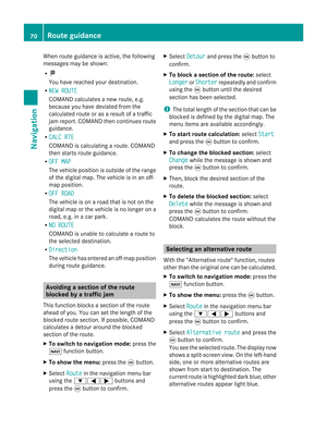 72
72 73
73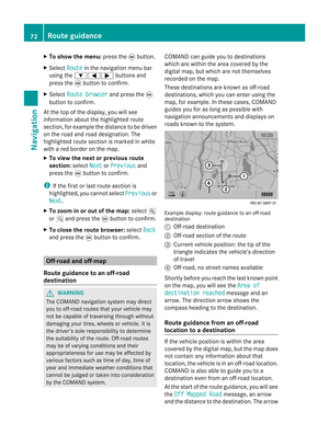 74
74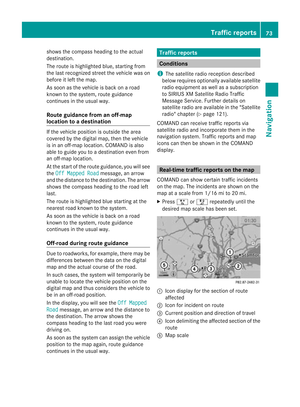 75
75 76
76 77
77 78
78 79
79 80
80 81
81 82
82 83
83 84
84 85
85 86
86 87
87 88
88 89
89 90
90 91
91 92
92 93
93 94
94 95
95 96
96 97
97 98
98 99
99 100
100 101
101 102
102 103
103 104
104 105
105 106
106 107
107 108
108 109
109 110
110 111
111 112
112 113
113 114
114 115
115 116
116 117
117 118
118 119
119 120
120 121
121 122
122 123
123 124
124 125
125 126
126 127
127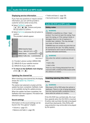 128
128 129
129 130
130 131
131 132
132 133
133 134
134 135
135 136
136 137
137 138
138 139
139 140
140 141
141 142
142 143
143 144
144 145
145 146
146 147
147 148
148 149
149 150
150 151
151 152
152 153
153 154
154 155
155 156
156 157
157 158
158 159
159 160
160 161
161 162
162 163
163 164
164 165
165 166
166 167
167 168
168 169
169 170
170 171
171 172
172 173
173 174
174 175
175 176
176 177
177 178
178 179
179 180
180 181
181 182
182 183
183 184
184 185
185 186
186 187
187 188
188 189
189 190
190 191
191 192
192 193
193 194
194 195
195 196
196 197
197 198
198 199
199 200
200 201
201 202
202 203
203 204
204 205
205 206
206 207
207 208
208 209
209