Page 73 of 190

i
The length ofthe blockable routesection
is predetermin edbythe digital map.The
menu itemsareavailab leaccordin gly.
X To star trout ecalculation: selectStart
and press Wtoconf irm.
X To delete theblocked section: select
Delete whilethemessage isshown and
press Wtoconf irm.
COMAND calculates theroute without the
block. Selecting
analter native route
With the"Altern ativeroute" function,routes
other thantheoriginal onecanbecalculated.
X To switch onnavigation mode:pressthe
g funct ionbutton .
X To show themenu: pressWthe COMAND
cont roller.
X Select Routeinthe navigation system
menu barbyturnin gcVd theCOMAND
cont roller andpress Wtoconf irm.
X Select Alternativ eRoute andpress W
to conf irm.
You seetheselected route.Thedisplay now
shows asplit-sc reenview. Onthe left- hand
side, oneormore alternat iveroutes are
shown fromstarttodestinat ion.The
curren troute ishighlighted darkblue; other
alternative routesappear lightblue.
On the right- hand side,inform ationonthe
current lyselected alternative routeis
shown, e.g.length ofroute, estimated
driving timeandestimated timeofarrival.
X To select thenext orprevious
alterna tiveroute:select Nextor
Previous andpress Wtoconf irm.
The selected routeishighlighted darkblue.
X To select theoriginal route:select Back
a correspon dingnumber oftimes andpress
W toconf irm. X
To star trout eguidance usingthe
selected alternativeroute:select Start
and press Wtoconf irm.
COMAND calculates thealternative route. Displaying
destinationinforma tion
You have enteredadestination (Y page 51)
or apoint ofinteres t(Y page 61)and possibly
an intermediate stop(Ypage 59).
X To switch onnavigat ionmode: pressthe
g func tion button.
X To show themenu: pressWthe COMAND
con troller.
X Select Routeinthe navigat ionsystem
menu barbyturn ingcVd theCOMAND
con troller and press Wtocon firm.
X Select Destin ationInformationand
press Wtocon firm.
Dest ination information isdisplayed. Ex
ample display: destinationinformation
: Dist ance, estimatedtime ofarrival and
estim atedremainin gdrivin gtime to
int ermediate stop
; Intermediate stopP
= State and city
? Dest ination O
A Dist ance, estimatedtime ofarrival and
estim ateddrivin gtime todestin ation
X To close thedestina tioninform ation:
slide XVY theCOMAND controller orpress
the k backbutton. Rout
eguida nce
71Navigat ion
ZACOMAND NTG4.0BR204USAEditionA2011 ;1; 3,en- US
d2iren kl Version:3.0 .3.6
2010
-05-31T09: 21:57+0 2:00-Seite 71 Z
Page 74 of 190

o")
Route
overvi ew
Yo ucan usethe routeove rvie wto move along
the routesecti onbysecti onand view
info rma tion anddeta ils ab ou teach sectiono f
the route.
Yo uha ve ente redade stinati on(Ypage 51)
or apo int ofinte rest(Y page 61)and possibly
an intermediate stop(Ypage 59)).
X To switch onnavigat ionmode: pressthe
g func tion button.
X To show themenu: pressWthe COMAND
con troller.
X Select Routeinthe navigat ionsystem
menu barbyturn ingcVd theCOMAND
con troller and press Wtocon firm.
X Select Route Browse rand press Wto
con firm.
At the top ofthe display, youwillsee
infor mation aboutthehighlighted route
sect ion,forexample thedistan cetobe driven
on the road androad designat ion.The
highlighted routesectionismark edinwhite
with ared border onthe map.
X To view thenext orprevious route
section: selectNextorPrevio usand
press Wtocon firm.
i Ifthe first orlast route sectionis
highlighted, youcann otselect Previo usor
Next.
X To zoom inor out ofthe map:select N
or M and press Wtocon firm.
X To close therout eoverview: select
Back andpress Wtocon firm. Off-
road andoff-m ap
Impor tantsafet yguidelines G
War
ning
The COMAND navigationsystem maydirect
you tooff- road routes thatyour vehicle may not
becapable oftrav ersing through without
damaging yourtires,wheels orvehicle. Itis
the driver’s solerespon sibility todeterm ine
the suitability ofthe route. Off-road routes
may beofvarying condition sand their
appropriaten essforuse may beaffect edby
various factorssuch astime ofday, time of
year andimmediate weathercondition sthat
cann otbe judged ortake ninto consi derati on
by the COMAND system .
Route guidanc eto ades tinatio nthat is
no ton adig itized road CO
MAND canguide yo uto destina tions
wh ich arewi thi nt he area covered bythe
digital map,butwhich arenot themselves
recorded onthe map.
These destinations areknown asoff-r oad
destinations, whichyoucan enter using the
map, forexample. Inthese cases, COMAND
guides youforaslong aspossible with
navigation announcemen tsand displa yson
roads known tothe system. Example
display:route guidance toan off-r oad
destination
: Off- road destination
; Off- road route section (dashed blue)
= Current vehicleposition (thetipofthe
triangle indicates thevehicle’s direction
of travel)
? Off- road (nostreet names available)
Short lybefore reaching thelast known point
on the map, youwillhear theannounc ement:
You will enter anarea with
unreliable mapdata inxxmiles. 72
Rout
eguidanceNa vigation
ZACOMAND NTG4.0BR204USAEdition A2011; 1;3,en-US
d2irenkl Version:3.0.3.6
2010-
05-31T09: 21:57+02: 00-Seite 72
Page 75 of 190

If
the vehicle reaches anarea which isnot part
of the digitalmap, thedisp layapp ears asa
spli t-screen view.Onthe right-hand side,an
arrow appears which points tooff-road
destination :.Youwill hear the
announc ement:"Please followthearrow on
the display" .Asthe vehicle approachesthe
destination, theArea ofdestination
reached message appears.
Route guidance fromanoff-road
location toad esti nation If
th eveh icle posit ioniswith inthearea
cov ered bythedigit almap, butthemap does
no tcon tain anyinform ationabout that
locat ion,th eveh icle isin an off-road locat ion.
COMA NDisalso able toguide youtoa
dest inationeven from anoff-road locat ion.
At thest art oftherout eguidan ce,you willsee
th eOff Mapped Roadmes sage, anarro w
and thedist anceto thed estin ation. Thearrow
shows thecompass headingtothe actual
destin ation.
The route ishighlighted blue,startingfrom
the last recogn izedstreet the vehicle wason
before itleft themap.
As soon asthe vehicle isback onaroad
kn own tothe system, routeguidance
con tinues inthe usual way.
Rout eguida ncefrom anoff-m ap
location toad esti nation If
th eveh icle posit ionisouts idethearea
cov ered bythedigit almap, then theveh icle
is in an off-map locat ion.COMAND isalso
able toguide youtoadestination evenfrom
an off-map location.
At the start ofthe route guidance,youwillsee
the Off Mapped Roadmessage, anarrow
and thedistance tothe destination. Thearrow
shows thecompass headingtothe road left
last.
The route ishighlig htedbluefrom thenearest
road known tothe system. As
soon asthe vehicle isback onaroad
known tothe system, routeguidance
cont inues inthe usua lway .
Off-road duringrouteguidance Due
toroad const ruction work,forexample,
there maybedifferences betweenthedata
on the digital mapandtheactual course of
the road.
In such cases, thesystem willtemporarily be
unable tolocate thevehicle position onthe
digital mapandthus considers thevehicle to
be inan off-road position.
In the displa y,you willsee theOff Mapped
Road message, anarrow andthedistance to
the destination. Thearrow shows the
compass headingtothe actual destination.
As soon asthe system canassign thevehicle
position tothe map again,route guidance
cont inues inthe usua lway . Tra
ffic report s Condition
s
To receive real-time trafficreports via
satellite radio,yourequire:
R optionally available satellite radio
equi pment
R asubscription toSIRIUS XMSatellite Radio
Traffic Message Service
Further information onsatellite radiois
avail able inthe "Satellite radio"section
(Y page 123).
COMAND canreceive trafficreports via
satellite radioandtake these intoaccount for
route guidanceinthe navigation system.
Received trafficreports aredispla yedinthe
map either astext oras icons. Real-time
traffic report son the map
COMAND canshow certain trafficincidents
on the map. Traffic reports areshown onthe
map atscales of0.05 mito20 mi. Tr
affic report s
73Navigat ion
ZACOMAND NTG4.0BR204USAEdition A2011; 1;3,en-US
d2irenkl Version:3.0.3.6
2010-0
5-31T09: 21:57+02:00-Seite 73 Z
Page 76 of 190
X
To hide themen u:slid eZV theCOMAND
contro ller and ,wh en the FullScr een
menu itemi sshown, pressWtoconfirm.
The map canbeseen inthe full-screen
displa y.
X Turn cVd theCOMAND controller untilthe
desired mapscale isset. 1
Icon delimiting thesection ofthe route
affected
2 Icon indicating anincident onthe route
(traffic flow)
3 Destination
4 Map scale 74
Tr
affic report sNavigat ion
ZACOMAND NTG4.0BR204USAEdition A2011; 1;3,en-US
d2irenkl Version:3.0.3.6
2010-0
5-31T09 :21:57+02:0 0-Seite 74
Page 77 of 190
 This
appear sat thebegi nning ofthe
aff ectedrou")
Icon
forreal-tim etraf fic rep orts Icon Descr
iption Tr
affic rep ortsin thema pdis pla y List
of
tr af fic
rep orts Tr
affic
rep orts Warn
ing
(re d) This
appear sat thebegi nning ofthe
aff ectedrout esec tion ifrout e
guidan ceisact ive and therout eleads
th roug han affectedarea. En
try typ e:
warn ing En
try
typ e:
warn ing Traf
fic
inc iden t
(yello w) This
appear sat thebegi nning ofthe
aff ectedrout esec tion ifrout e
guidan ceisact ive and therout eleads
th roug han area affectedby atraff ic
inc iden t. En
try typ e:
caut ion En
try
typ e:
caut ion Traf
ficjam
on rout e
(st op- and -go
tr aff ic) This
appear sat thebegi nning ofa
tr aff icjam (average speed
25 –45 mph )if rout eguidan ceis
act ive and therout eleads throug han
area ofcong est ed traff ic.
Yello wcar icons may appear in
co njunc tion withth is ico n. En
try typ e:
tr aff icjam
on rout e
(st op- and -
go traff ic) En
try
typ e:
tr aff icjam
on rout e
(st op- and -
go traff ic) Traf
ficjam
on therout e This
appear sat thebegi nning ofa
tr aff icjam (average speed
5–2 0mph)ifroute guidance isactiv e
and theroute leads through anarea of
con gested traffic.
Red caricon smay appear in
con junc tion with thisicon. En
try type:
traf ficjam
on route En
try
type:
traf ficjam
on route Block
ed
route section
on route Appears
atthe beginn ingofablock ed
route sectionifroute guidance is
activ eand theroute leads through the
block edsect ion.
The XXXX iconsmay appear in
con junc tion with thisicon. En
try type:
block ed
route
sect ion En
try
type:
block ed
route
sect ion Yellow
line with
arrows Traffic
inciden ts Possible
delays(e.g.roadwork )
Appears onthe side ofthe road
affec ted(direct ionoftrav el) (Not
available) (Not
available) Tr
aff icrep orts
75Navigat ion
ZACOMAND NTG4.0BR204USAEditionA2011 ;1; 3,en- US
d2iren kl Version:3.0 .3.6
2010
-05-31T09: 21:57+0 2:00-Seite 75 Z
Page 78 of 190

Icon Descr
iption Tr
affic rep ortsin thema pdis pla y List
of
tr af fic
rep orts Tr
affic
rep orts Gree
n
lin ewit h
arr ows Un
impe ded
tr aff icflo w No
delays
On lyappear son theside oftheroad
(dir ection oftravel) onwhic htraff ic
flo wisunim peded (Not
availab le) (Not
availab le) Red
line
wit h
arr ows Warn
ing
mes sage In
cid enton road
Ap pear son theside ofther oad
affect ed(direction oftravel) (Not
availa ble) (Not
availa ble) Displaying
real-timetraffic repor ts
X To switch onnavigation mode:pressthe
Ø functionbutton .
X To show themenu: pressWthe COMAND
cont roller.
X Select Traffic byturnin gcVd the
COMAND controller andpress Wto
conf irm.
If the dialog fieldshows theNoTraffic
Messages message,thismeans that:
R no traffic reports havebeen received yet.
R no traffic reports areavaila ble.
X To cancel thesearch: selectCancel and
press Wtoconf irm.
X To close thereport window: selectOK
and press Wtoconf irm.
If traffic reports exist,alist isshown.
The cont entofthe listvaries depending on
whether routeguidance isactive ornot .
List when routeguidance isnot active The
listshows allthe roads, areasorregions
for which reports areavaila ble. A
traffic report mayrefer toan area ora
region, e.g.ifvisibility isimpaired duetofog.
X To read atraffic report :select aroad,
area orregion byturnin gcVd the
COMAND controller andpress Wto
conf irm.
List when routeguidance isactive The
first listshows theroads, areasand
regions thatliealong theroute andforwhich
traffic reports areavaila ble. 76
Tr
affic repor tsNavigation
ZACOMAND NTG4.0BR204USAEdition A2011; 1;3,en-US
d2irenk lV ersion:3.0.3.6
2010
-05-31T09 :21:57+0 2:00-Seite 76
Page 79 of 190

X
To sho wall repo rts:select Dis playAll
Mes sagesbyturning cVd theCOMAND
contro ller and pressW toconfi rm.
Yo usee alist of allroa ds, area sand regions
for which trafficrep orts areav ailabl e, eve n
if the reports donot affect your rou te. X
To sho watraffi crepo rt:select aroa d,
ar ea orreg iona nd pre ssW toconfi rm.
X To clos ethe list: slid eXVY theCOMAND
contro ller. Ex
ample :traffi crepo rt 1
Dep endingonyour sel ecti on: Rea dout
all messagesonrouteorAll
Mes sages
2 Report8of 16 for the roadaf fecte d
3 Text of rep ort
4 Road,ar ea orreg iona ffected bytraffic
reports
5 Icon forstate/pro vince
6 Icon forreport type,e.g. traffic flow
messa ge
X To scro llwi thin arepor tortoaccess
th enext report:tur ncVd theCOMA ND
con troller .
X To returnto therep ort:slide XVY the
COMA NDcontroller .
Displa yingtraf fic rep ortson thema p X
Sele ctTra fficSym bol Informationby
tur nin gcVd theCOMA NDcontroller and
pres sW tocon firm. Tr
affic rep orts
77Navigat ion
ZACOMA NDNTG4 .0BR2 04USA EditionA201 1;1;3,en- US
d2ir enklV ersion:3.0.3.6
2010
-05-31T09 :21:57+0 2:00-Seite 77 Z
Page 80 of 190

Exam
ple displ ay
: Road conce rned
; Icon forreport type,e.g .traf ficflow
mes sage
X Sel ect Nextor Pre viousbyturning cVd
the COMAND controller and pressW to
confi rminord erto conti nuehighl ighti ng
traf ficicons.
X To chang ethe map scale :sel ect Map by
sl id ing ZV theCOMAND controller and
pre ssW toconfi rm.
Yo ucan now zoom inor outof the map.
X To sho wthe detai ledv iew: select
Detai lsand press Wtocon firm . Ex
ample display: traffic iconinformat ion
X To close thedet ailed view: slideXVY the
COMAN Dcon troller. Hav
ingtraff icrep ortson therou te
rea dout
Intr oduct ion The
read- aloud functionisonly available while
rout eguidanc eis act ive. Itreads outtraffic
repor tsaffec tingthe curr entrout e.You can
set the language (Y page 45)and theread-
aloud speed (Ypage 39).
You canstartthe read-aloud function
manually orset itto automatic.
Star ting theread- aloud function
manua lly X
To switch onnavigation mode:pressthe
Ø functionbutton.
X To show themenu: pressWthe COMAND
cont roller.
X Select Traffic byturning cVdthe
COMAND controller andpress Wto
confirm .
X Select Readoutallmessages on
route andpress Wtoconfirm .
COMAND readsoutthereports insequence.
i Ifthere arenoreports forthe route, the
Read outallmessages onroute menu
item isshown ingray andcannot be
selected.
X To switch offthe read- aloud function:
select Cancel read-aloud functionand
press Wtoconfirm orpress the8
button.
COMAND readsthecurrent reportaloud
and then exits theread-aloud function.
Automat icread- aloud function X
To switch onnavigation mode:pressthe
Ø functionbutton. 78
Tr
affic report sNavigat ion
ZACOMAND NTG4.0BR204USAEdition A2011; 1;3,en-US
d2irenkl Version:3.0.3.6
2010-
05-31T09:21 :57+02:00-Seite 78
 1
1 2
2 3
3 4
4 5
5 6
6 7
7 8
8 9
9 10
10 11
11 12
12 13
13 14
14 15
15 16
16 17
17 18
18 19
19 20
20 21
21 22
22 23
23 24
24 25
25 26
26 27
27 28
28 29
29 30
30 31
31 32
32 33
33 34
34 35
35 36
36 37
37 38
38 39
39 40
40 41
41 42
42 43
43 44
44 45
45 46
46 47
47 48
48 49
49 50
50 51
51 52
52 53
53 54
54 55
55 56
56 57
57 58
58 59
59 60
60 61
61 62
62 63
63 64
64 65
65 66
66 67
67 68
68 69
69 70
70 71
71 72
72 73
73 74
74 75
75 76
76 77
77 78
78 79
79 80
80 81
81 82
82 83
83 84
84 85
85 86
86 87
87 88
88 89
89 90
90 91
91 92
92 93
93 94
94 95
95 96
96 97
97 98
98 99
99 100
100 101
101 102
102 103
103 104
104 105
105 106
106 107
107 108
108 109
109 110
110 111
111 112
112 113
113 114
114 115
115 116
116 117
117 118
118 119
119 120
120 121
121 122
122 123
123 124
124 125
125 126
126 127
127 128
128 129
129 130
130 131
131 132
132 133
133 134
134 135
135 136
136 137
137 138
138 139
139 140
140 141
141 142
142 143
143 144
144 145
145 146
146 147
147 148
148 149
149 150
150 151
151 152
152 153
153 154
154 155
155 156
156 157
157 158
158 159
159 160
160 161
161 162
162 163
163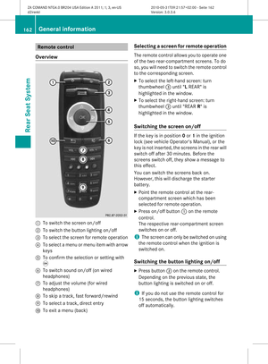 164
164 165
165 166
166 167
167 168
168 169
169 170
170 171
171 172
172 173
173 174
174 175
175 176
176 177
177 178
178 179
179 180
180 181
181 182
182 183
183 184
184 185
185 186
186 187
187 188
188 189
189