2017 AUDI TT ROADSTER diagram
[x] Cancel search: diagramPage 21 of 314
CD
CD
.... N
" N .... 0 r--. V, co
Driver information system
Overview
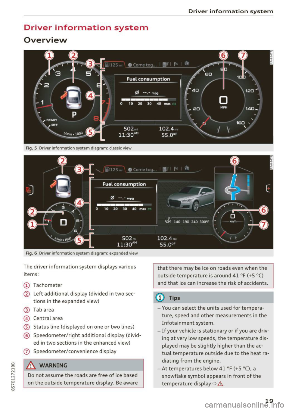
Fig. S Dr iver information system diagram: classic v iew
Fig. 6 D river information system diagram : expanded view
The driver information system displays various
items:
@ Tachometer
@ Left additional display (divided in two sec-
tions in the expanded view)
@ Tab area
@ Central area
® Status line (displayed on one or two lines)
@ Speedometer/right additional display (divid-
ed in two sections in the enhanced view)
(J) Speedometer/convenience display
A WARNING
Do not assume the roads are free of ice based
on the outside temperature display . Be aware
Driver in forma tion system
that there may be ice on roads even when the
outside temperature is around 41 °F ( +S °C)
and that ice can increase the risk of acc idents.
(D Tips
- You can select the units used for tempera
ture, speed and other measurements in the
Infotainment system.
- If your vehicle is stationary or if you are driv
ing at
very low speeds, the temperature dis
played may be slightly higher than the ac
tual temperature outside due to the heat ra
diating from the engine.
- At temperatures below 41 °F (+S °C), a
snowflake symbol appears in front of the
temperature display~ ,&.
19
Page 104 of 314
Multi Media Interface
Opening the selection/
options menu with the
control knob
Applies to: vehicles with joystick function
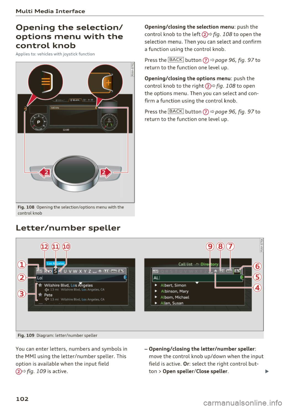
Fig. 108 Opening the sele ctio n/op tions men u w ith the
con tro l knob
Letter/number speller
Fig. 109 Diagram : letter/ number spe ller
You can ente r letters, numbers and symbo ls in
the MMI using the letter/number speller. This
option is available when the input field
@¢fig. 109 is active .
102
Opening/closing the selection menu: push the
contro l knob to the left @¢
fig. 108 to open the
selection menu . T hen you can select and confirm
a function using the control knob.
Press the
I BACK ! button 0 ¢ page 96, fig. 97 to
return to the funct ion one level up.
Opening/closing the options menu: push the
control knob to the right@¢
fig. 108 to open
the options menu. Then you can select and con
firm a function using the control knob.
Press the
I BACK I button 0 ¢ page 96, fig. 97 to
return to the function one leve l up .
-Opening/closing the letter/number speller:
move the contro l knob up/down when the input
field is active .
Or: select the right control but-
ton
> Open speller/Close speller. II>
Page 107 of 314
CD
CD
.... N
" N ...... 0
" V, co
Multi Media Interface
Menus and Symbols
I~ :c
' ~
@
14
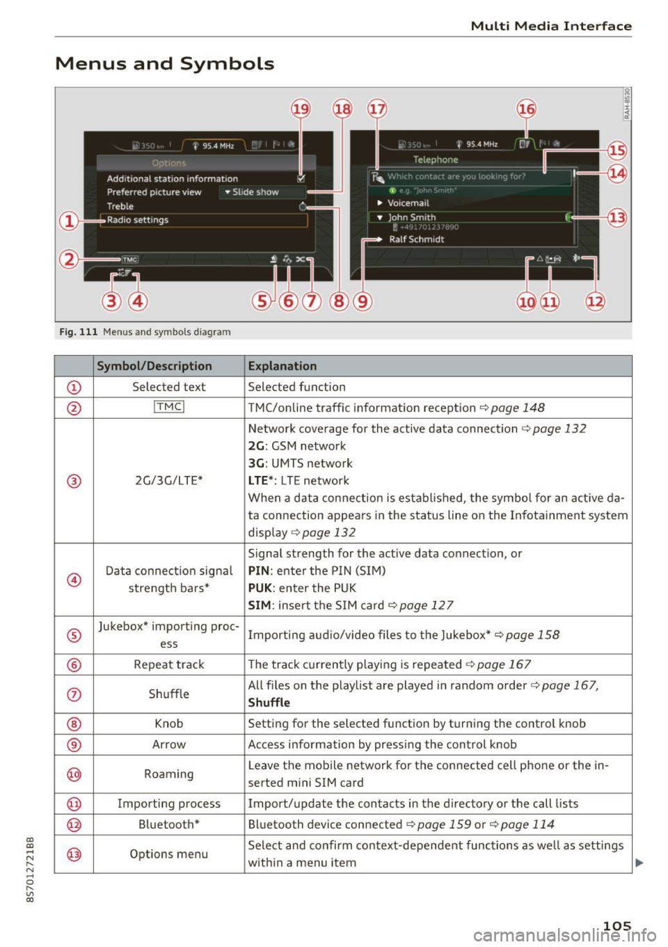
Fig. 111 Menus and symbols diagram
Symbol/Description Explanation
CD Selected text Selected function
@ I
TMC I TMC/online traffic informat ion recept ion c::>page 148
Network coverage for the active data connection c::> page 132
2G: GSM network
3G : UMTS network
® 2G/3G/LTE* LTE *: LTE network
When a data connection is establ ished, the symbol for an act ive da-
ta connection appea rs in the status line on the Infota inment system
display
c::> page 132
Signal strength for the active data connect ion, or
@
Data connect ion signa l PIN: enter the PIN (SIM)
strength bars*
PUK : enter the PUK
SIM: insert the SIM card c::> page 12 7
®
Jukebox* importing proc-
Importing audio/video files to the Jukebox*
c::> page 158
ess
® Repeat track The track currently playing is repeated c::>page 167
0 Shuffle All files on the playlist are played in random o
rder
c::> page 167,
Shuffle
® Knob Setting for the selected function by turning the control knob
® Arrow Access information by pressing the control
knob
@ Roaming Leave the mobile network for the connected cell phone or the in-
serted mini SIM card
@ Importing process Import/update the contacts in the directory or the call lists
@ Bluetooth* Bluetooth device connected c::> page 159 or c::> page 114
@ Options menu Select
and confirm context-dependent functions as well as settings
within a menu item
105
Page 138 of 314
Navigation
Navigation
Opening navigation
A pplies to: ve hicles w ith navigation system
The navigation system directs you to your destination, around traffic incidents and on alternative
routes, if desired.
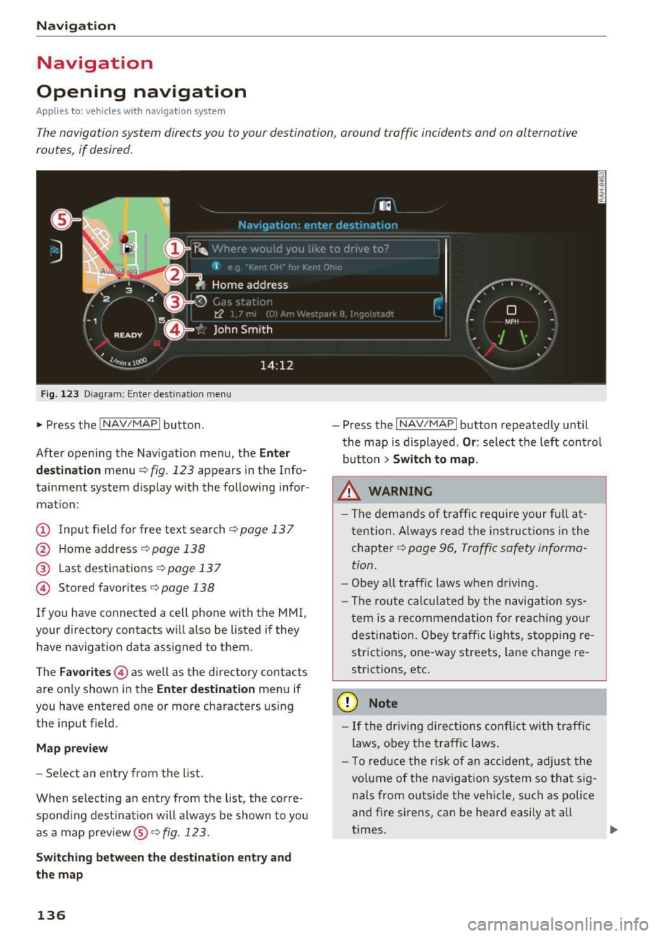
Fig. 123 Diagram: Enter destination menu
~ Press the I NAV/MAPI button.
After opening the Navigation menu, the
Enter
destination
menu Q fig. 123 appears in the Info
tainment system display with the following infor mat ion:
(!) Input field for free text search q page 13 7
@ Home address 9poge 138
@ Last destinations qpoge 137
© Stored favorites q page 138
If you have connected a cell phone with the MMI,
your directory contacts will also be listed if they
have navigation data assigned to them .
The
Favorites © as well as the directory contacts
are only shown in the
Enter destination menu if
you have entered one or more characters using the input field.
Map preview
-Select an entry from the list.
When selecting an entry from the list, the corre
spond ing dest ination will always be show n to you
as a map preview®~
fig. 123.
Switching between the destination entry and
the map
136
- Press the I NAV/MAPI button repeatedly until
the map is displayed .
Or: select the left control
button
> Switch to map.
.&_ WARNING
-The demands of traffic require your full at
tention. Always read the instructions in the
chapter
9 page 96, Traffic safety informa
tion.
- Obey all traffic laws when driving.
- The route calculated by the navigation sys-
tem is a recommendation for reaching your
destination. Obey traffic lights, stopp ing re
strictions, one-way streets, lane change re
strictions, etc.
(D Note
- If the dr iving directions conflict with traffic
laws, obey the traffic laws.
- T o reduce the risk of an accident, adjust the
volume of the navigation system so that sig
nals from outside the vehicle, such as police
and fire sirens, can be heard easily at all
times.
-
Page 146 of 314
Navigation
~ Select: right contro l button > Show alternative
routes.
Up to three route suggestions and their proper
ties are displayed on the map when this function
is switched on¢
fig. 128.
If available, the following information w ill ap
pear on the route suggestions:
- Route type (fast
(D, fast a lternative @, eco
nomic route@)
- Distance to the destination and the calculated arrival time
- Heavy traffic along the route including time de
lays
Map
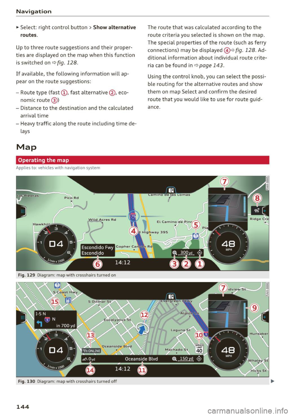
Operating the map
Applies to: veh icles with navigation system
Escondido Fwy
Escondido
Fig. 129 Diag ram : map with crossha irs t urned on
Fig. 130 Diagram : map with crossha irs tu rned off
144
The route that was calculated according to the
route criteria you selected is shown on the map.
The special properties of the route (such as ferry
connections) may be displayed @¢
fig. 128 . Ad
ditional information about individual route crite
ria can be found inc:;,
page 143 .
Using the control knob, you can select the poss i
ble routing for the alternative routes and show
them on map Select and confirm the desired route that you would like to use for route guid
ance.