2015 MERCEDES-BENZ SLS AMG GT COUPE sat nav
[x] Cancel search: sat navPage 22 of 202
Menu
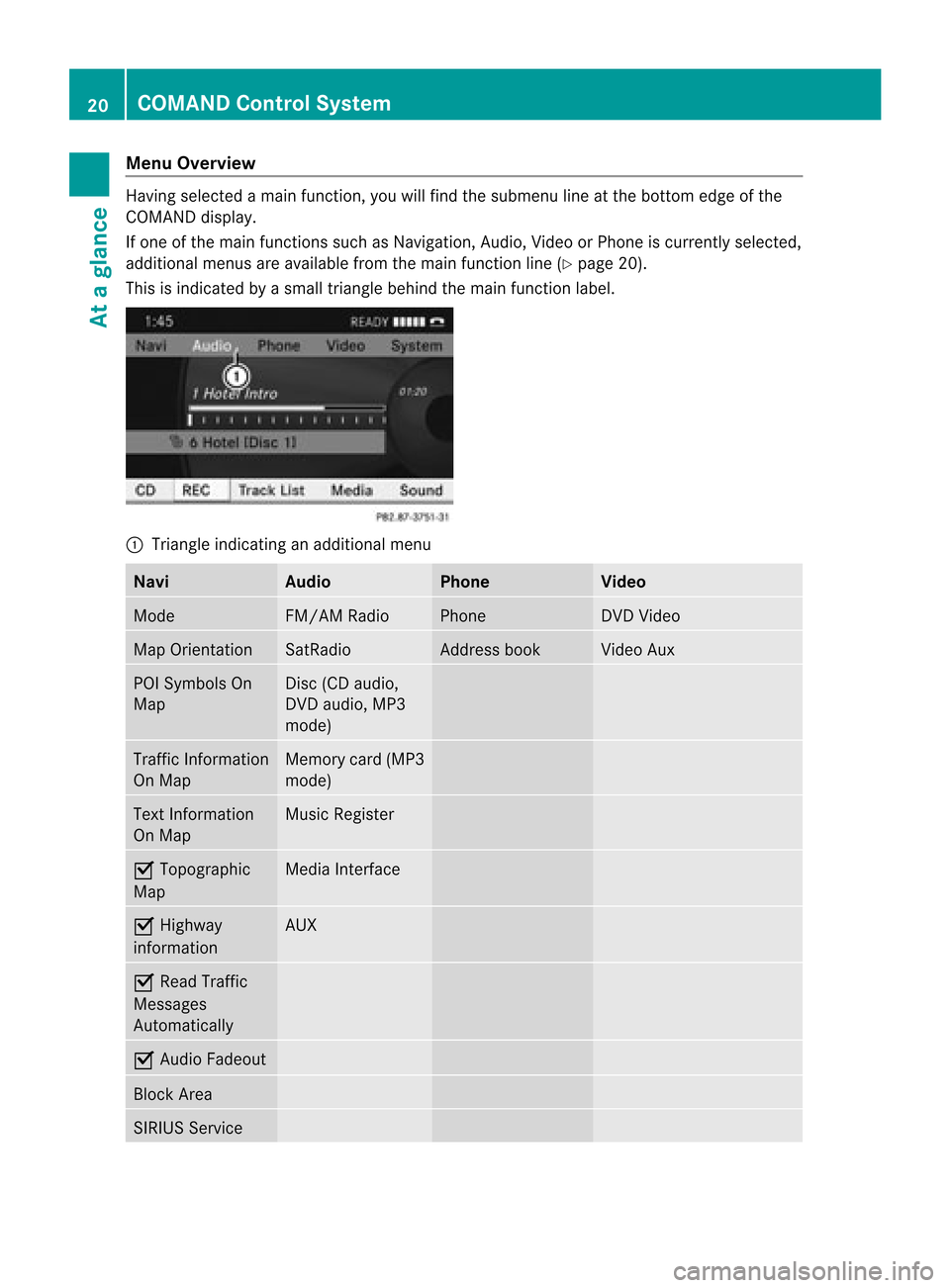
Overvi ew Having
selected amai nfunc tion ,you willfindth esubm enulin eat thebot tome dge ofthe
COMAND display.
If one ofthe main functionssuch asNavigation ,Audio, Videoor Pho neiscur ren tly sele cted,
addit ionalmen usare availab lefrom themain function line(Y page 20).
This isind icat edbyasmal ltriangl ebehi ndthe main function label. 1
Tria ngle indica tinganadd itiona lmenu Navi Audio Phone Video
Mode FM/AM
Radio Phone DVD
Video Map
Orientatio n SatRa
dio Address
book Vide
oAux POI
Symbol sOn
Map Disc
(CDaudio,
DVD audio, MP3
mode) Traffi
cInformation
On Map Memory
card(MP3
mode) Text
Information
On Map Musi
cRegister Ç
Topographic
Map Media
Interface Ç
Highway
infor mation AUX
Ç
Read Traffic
Messages
Autom atically Ç
Audio Fadeout Block
Area SIRIUS
Service 20
COMAND
ControlSystemAtaglance
Page 57 of 202

Gene
ralInfo rmat ion
Operational Readinessofthe
Navigation SystemaftertheSystem
Software Update Sometimes
theinstall edmap software isno
longer compatib lefollo wing asystem
software update byan authorized Mercede s-
Benz Center. Inthis case, thenaviga tion
system isnot opera tional.
X To update mapsoftware :Proceed as
describ edinthe “Upda teProcess” section
(Y page 53).Usemap software compatib le
with thesystem software .
i Plea senote thatinthis case theupdate
must runthrough righttothe end. Ifyou
cancel beforeh and,thenaviga tionsystem
wil lstill notberead yfor opera tion.
After start-up orinitia lstart-up, thenaviga tion
system mustperform aposi tion finding
opera tion.Asaresul t,you may have todrive
for some timeuntilprecise routeguidance
takes place.
GPS Rece ption The
correct functioning ofthe naviga tion
system isals odepe ndent onthe GPS
reception. Incertain situations, theGPS
reception maybeimpa ired, distorted oreven
imposs ible, e.g. intunnels, multi-storey car
parks ordue tosnow onthe GPS antenna. If
there issnow onthe GPS antenna, youshou ld
remove it.The GPS antenna isat the rear on
the vehicle 'sroof.
Route Guidance afterVehic leTransport After
vehicle transport (e.g.byferry, cartrain
or by towing) COMAND mustdetermine the
vehicle locationagain.
Position findingtakesplaceautomatically
when thevehicle isdriven offagain, evenif
COMAND isswitched off.The actual length of
time mayvaryfrom casetocase. While
thevehicle isdetermin ingitsposition,
route guidance issubject tothe following
restric tions:
R Navigation announcements,route
guidance displaysand display edstreet
names donot match theactual location.
R COMAND doesnotissue anynavigation
announc ements.
R The message OffMapped Road and
a
direction arrowaredisplay edinstead ofthe
route guidance displays.The arrow
indicates thedirection ofthe destination .
i Direct ionarrow accuracy isalso
dependent oncorrec tvehicle position
and/or direction.
Onc ethe position findingoperation hasbeen
complet ed,route guidance takesplaceagain
via navigation announcementsand route
guidance displays.
Interr upting Journey during Rout e
Guida nce i
Aninterruption inthe journ eymeans
parkin gthe vehicle andswitch ingoffthe
vehicle.
The continuation ofthe journ eymeans
switch ingthe vehicle onagain and
con tinuing todrive.
If you interrupt thejourn eyduring route
guidance andcontinue itlater, thefollowing
applies:
R Ifyou continue the journ eywithin 2hours,
COMAND automatically continues route
guidance.
R Ifyou cont inue thejourney after2hours,
route guidance iscanceled. Youwillhave
to cont inue thecanceled routeguidance
again manually (Ypage 89).
Measur ementUnits The
measurement unitsdisplay edin
navigation modeareidentical tothose setin
the instr ument cluster. Introdu
ction
55Navigation Z
Page 62 of 202

Same
asDyn amicRou te wi
th the
excep tionthatame ssageapp ears asking
you whethe ryou want toallow the
rerouting ornot .
R Fast Route COMAND
calculates aroute byminimizin g
the driving timewithout takinginto acount
traffic messages.
R Avoid Highways R
Avoid TollRoads R
Avoid Tunnels R
Avoid Ferries R
Avoid AutoTrains 1
Route calculation mode
; Route options
Setting RouteCalculation Mode
X Display menusystem ifapplicabl e
(Y page 58).
X Select Navi £
Mode .
X Select Short Route ,
Dynamic Route ,
Dynamic Route Only After Request or
Fast Route .
X To exit menu: Slideomp .
Setting RouteOptions
X Display menusystem ifappli cable
(Y page 58).
X Select Navi £
Mode .
X To switch routeoption on/off: Select
required option.
Depending onthe previous status,the
option willbeswitched onÇ oroffc.
You may activate severaloptions. i
The calculated routemayinclude ferry
conn ections ,for example, evenifthe
operation AvoidFerries has
been
activated.
i Ifyou change theroute mode setting
when routeguidanceisactive, COMAND
calculates anew route.
Map Display Map
Orientat ion 1
Currently setmap orientation
The following displaysare possible:
R 9=o rientatio ntonort h(the map display
is orient edtothe nort h,nort his alwa ysat
the top)
R 8=D rivingdirection (themap displayis
oriented inthe direction oftravel, the
dire ction oftravel isalw aysat the top, the
orange tipofthe symb olpoints
northward s)
R 8=B ird's-eye view
(t he map display isorien tedinthe direc tion
of travel, themap projection repr oduces
the curv ature ofthe eart h'ssurf ace, the
oran getip ofthe symbol points
nor thwar ds) 60
Intr
odu ctionNavigat ion
Page 63 of 202

Exam
ple of ma pfrom bird' s-ey evie w
1 Curre ntcros shairslocati on
2 Curre ntly setmapori enta tion
X To setmap orientatio n:Dis play menu
sy stem ifap plica ble (Y page 60) .
X Sel ect Navi £
Map Display .
Ad otR indicates thecurrent setting. 1
Options formap orient ation
X Select North Up or
Heading Up or
Bird's-eye View .
X To exit menu: Slideomp .
X Hide menu systems ifap plicab le
(Y page 58).
The map orientati onchang esaccor dingly.
Setti ngPOI Symbo ls You
canselect whichPOIs aretobe displa yed
as symbol son the map .Points ofinter ests
include, forexample, gasstation ,hotels,
cinemas andrestaurant s. 1
Options forPOI symbols (Ypage 61).
X To set: Display menusystem ifapplicabl e
(Y page 58).
X Select Navi £
POI Symbols OnMap .
X Select Standard Symbols or
Personal Symbols or
No Symbols .
The settings have thefollowing effect:
R Standard Symbols Displays
thefactor y-setsymbols
R Personal Symbols The
listofPOIs isdisplay ed
R No Symbols No
POI symbols areshown onthe map.
i The listindicates allsymbols forall
count riesthat arecont ained inthe digital
map. However, notallPOIs areavailba lein
all count ries.Asaresult, certainPOI
symbols maynotbeshown onthe map
even though thesymbol displayisswitched
on.
X To exit menu: Slideomp .
X Hide menu system ifap plicab le
(Y page 58).
Traffic Informatio non Map Provi
dedyouhav easub scrip tiontoSIRIU S
XM Satel lite Radio Traffic Mess ageServi ce,
yo ucan havethe traffi cinform ation displ ayed
on the map.The rearethre ediffer ent
cate goriesof info rma tiony ou can select. Introdu
ction
61Navigation Z
Page 65 of 202
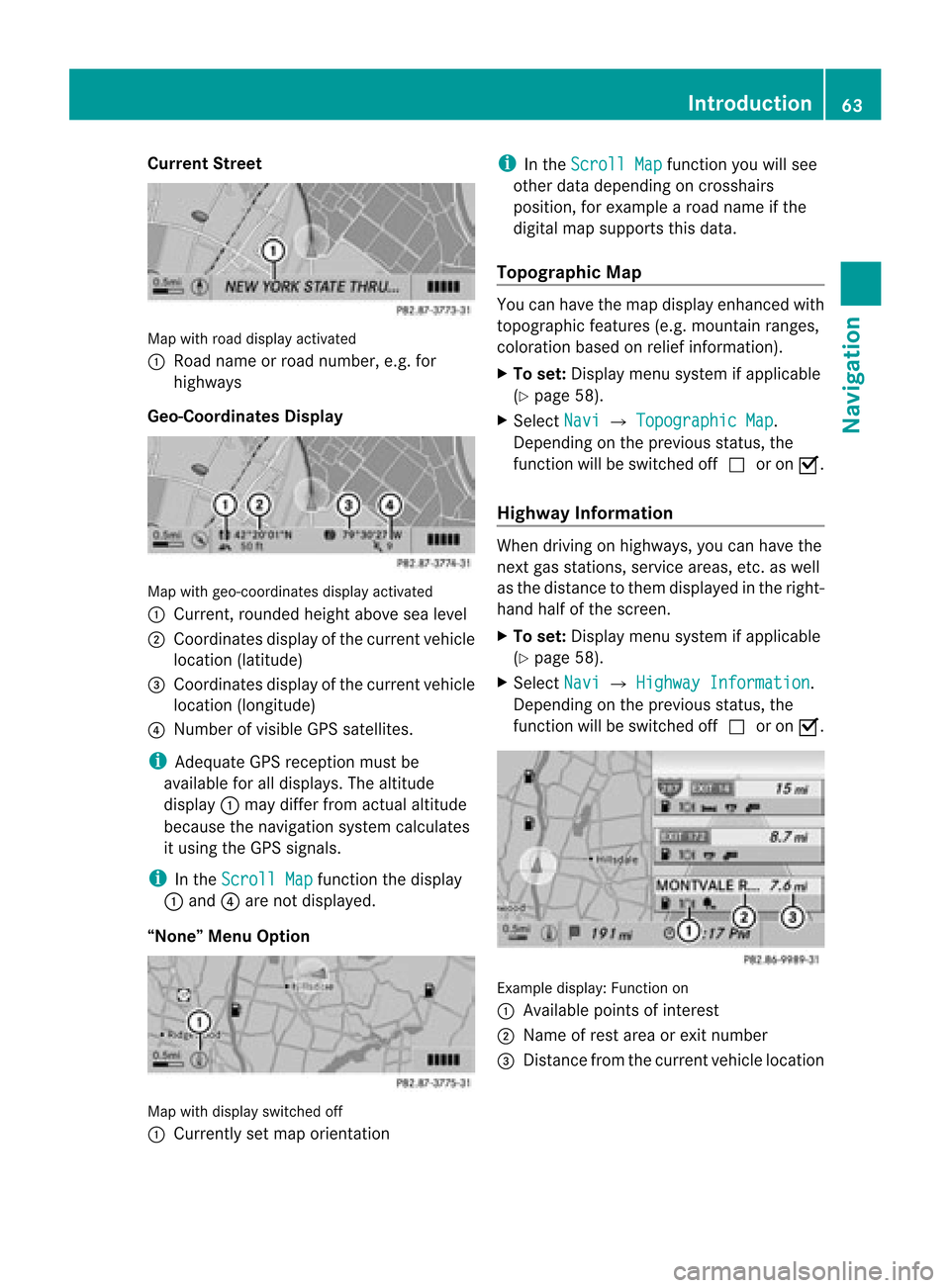
Cur
rentSt reet Map
withroad displayact ivat ed
1 Road nameor road number, e.g.for
highway s
Geo-Coordinates Display Map
withgeo-coor dinatesdisplayactivated
1 Current, rounded heightabovesealevel
2 Coordinates displayofthe current vehicle
location (latitude)
3 Coordinates displayofthe current vehicle
location (longitude)
4 Number ofvisible GPSsatellites.
i Adequate GPSreception mustbe
availa bleforalldisplay s.The altitude
display 1may differ fromactual altitude
because thenavigation systemcalculates
it using theGPS signals.
i Inthe Scroll Map funct
ionthe display
1 and 4are not display ed.
“None” MenuOption Map
withdisplay switched off
1 Currently setmap orientat ion i
Inthe Scroll Map funct
ionyou willsee
other datadepending oncrosshairs
position, forexample aroad name ifthe
digital mapsupports thisdata.
Topogra phicMap You
canhave themap display enhancedwith
topographic features(e.g.mountain ranges,
coloration basedonrelief informat ion).
X To set: Display menusystem ifapplicabl e
(Y page 58).
X Select Navi £
Topographic Map .
Dependin gon the previous status,the
funct ionwill beswitched offcor onÇ.
Highway Information When
driving onhighway s,you can have the
next gasstation s,service areas,etc.aswell
as the distance tothem display edinthe right-
hand halfofthe screen .
X To set: Display menusystem ifapplicabl e
(Y page 58).
X Select Navi £
Highway Information .
Dependin gon the previous status,the
funct ionwill beswitched offcor onÇ. Example
display:Functionon
1 Available pointsofinter est
2 Name ofrest area orexit number
3 Distan cefrom thecurrent vehiclelocation Introdu
ction
63Navigation Z
Page 67 of 202
Disp
laying andC hangi nganExisting
Bloc kArea X
To select the areayo uwa nttodis pla y
or chang e:Slide qmr .
X Sel ect Option s £
Display/Change .
The map displ ayappe ars with the block
are amar ked red.
X To setthe map scale :Ro tate ymz .
X To scrol lthe map: Slideqmr ,omp or
wmx .
X To def inethe cente rof the bloc karea :
Pre ssn.
X To setthe desi redsize ofthe blockarea:
Rota teymz .
X To confi rm the area andexitmap
dis play :Pre ssn.
X Hid emenu system ifap plica ble
(Y page 58) .
De finingaN ew Block Area
X Sele ctOpt ion s £
AvoidNew Area The
map isdisplayed.
X To set thema pscale: Rotateymz .
X Rot ate ymzunt ilth edesi redsizeof the
ne wbloc karea isset.
X Slide qmr ,ompor wmxtoshiftthe
new block area tothe desired region.
X To confi rm the areaand exitmap
dis pla y:Pre ssn.
X Hid emenu syste mifapplicable
(Y page 58).
Deleting aBlock Area
X To select thear ea you want todelet e:
Slide qmr .
X Sel ect Option s £
Delete .
Yo uwi llbe pro mpte dto confi rmthatyou
wish todelete theblock area.
X Select Yes or
No .
If you select Yes COMAND
deletesthe
entr y. SIRIUS
XMTraffic Service
You candisplay theSIRIUS XMServic e
informat ion.
X To display theSIRIUS XMservice
informa tion:Select Navi £
SIRIUS Service
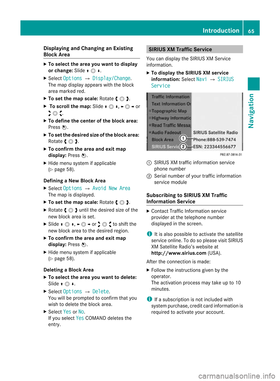
:
SIRIUS XMtraffic informat ionservice
phone number
; Serial number ofyour traffic informat ion
service module
Subscribing toSIRIUS XMTraffic
Informat ionService X
Contact TrafficInformation service
provider atthe telephone number
display edinthe screen .
i Itis also possible toactivate thesatellite
service online.Todo soplease visitSIRIUS
XM Satellite Radio’swebsite at
htt <0010002D00220022001700170017002100130009001200090015001300210003
000F000DF (USA).
Aft erthe conn ection ismade:
X Follow theinstr uctions givenbythe
operator.
The activation processmaytake upto10
minutes.
i Ifasubscription isnot included with
system purchase, creditcardinform ationis
required toactivate youraccount . Introdu
ction
65Navigation Z
Page 69 of 202
R
Last States/Provinces R
States (U.S.A.) or
R Provinces (Canada) .
X To sele ctalist: Rotat eymzor slide
qmr .
X Press n.
The selected state/provinc elist appears.
X To selected astate/ province :Ro tate
ymzor slideqmr .
X Press n.
The Enter Dest ination menuappears again.
The selected state/provinc ehas been
ent ered automatically.
Entering aCity i
You canonly entertho secities that are
sto red inthe digital map.Anyzip code that
has already beenentered isdelete dwhen
a cit yis ent ered.
X In the Enter Des tination menu,selec t
City .
The citylist isdisplayed withorwithout
predic tivespeller. Thedisplay ofthe
predic tivespeller dependson how many
cit ies are available forthe selec tedstate/
prov ince.
City Listwith Predictive Speller
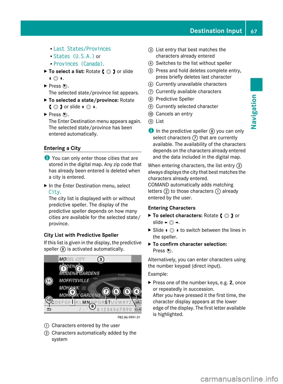
If this listisgiven inthe display, thepredic tive
speller 8isact ivate dautomat ically. 1
Charact ersentered bythe user
2 Charact ersautomat icallyadded bythe
syste m 3
List entrythat best matc hesthe
char acters already entered
4 Swit ches tothe listwithout speller
5 Press andhold delete scom plete entry,
press briefly deleteslast char acter
6 Curren tlyunavailable characters
7 Curren tlyavailable characters
8 Predic tiveSpeller
9 Curren tlyselec tedchar acter
a Cance lsan ent ry
b List
i Inthe predic tivespeller 8you can only
selec tcharacters 7that arecurrent ly
availa ble.Theavaila bilityofthe characters
depends onthe characters alreadyentered
and thedata included inthe digital map.
When enterin gcharacters, thelistentr y3
alwa ysdispla ysthe city that best matches the
characters alreadyentered.
COMAND automatically addsmatching
letters 2tothose characters 1already
entered bythe user.
Entering Character s
X To selec tcharacters: Rotateymzor
slide omp .
X Sli de qmr tosw itch betwe enthe lines in
the speller.
X To confi rm charac terselecti on:
Pre ssn.
Alte rnatively, yo ucan ente rcharacters using
the number keypad(directinput).
Example:
X Press oneofthe number keys,e.g.2,once
or repeatedly insuccession.
Aft eryou have pressed itthe first time, the
character displayappea rsat the lower
edge ofthe displa y.The first letter available
is highlighted. Des
tination Input
67Navigat ion Z
Page 84 of 202
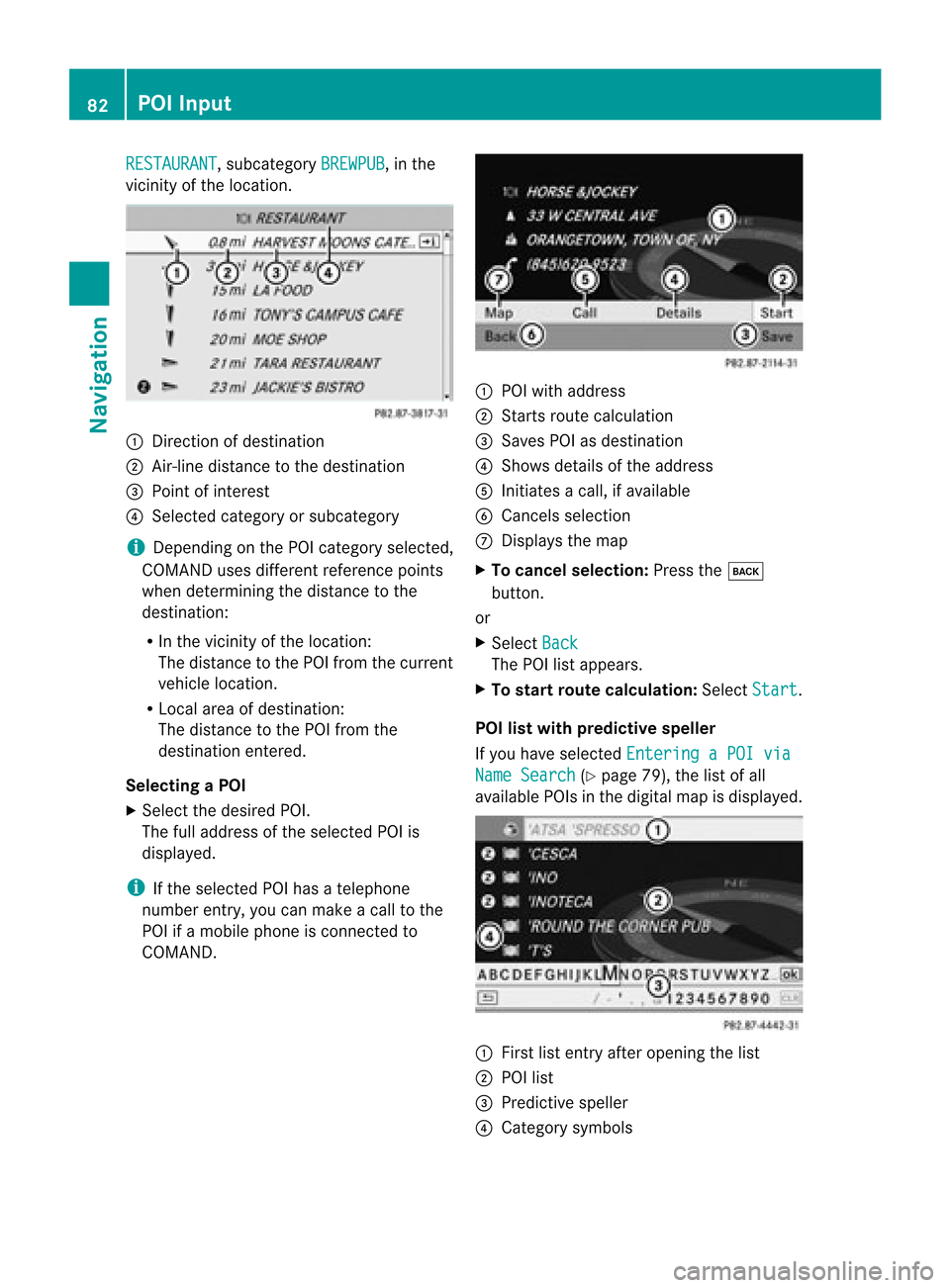
RESTAURANT ,
subcategory BREWPUB ,
in the
vicinity ofthe location. 1
Direction ofdestination
2 Air-line distance tothe destination
3 Point ofinterest
4 Selected categoryorsubcategory
i Depending onthe POI category selected,
COMAND usesdifferent reference points
when determining thedistance tothe
destination:
R In the vicinity ofthe location:
The distance tothe POI from thecurrent
vehicle location.
R Local areaofdestination:
The distance tothe POI from the
destination entered.
Selec tingaPOI
X Select thedesired POI.
The fulladdress ofthe select edPOI is
displayed.
i Ifthe select edPOI hasatelephone
number entry,you can make acall tothe
POI ifamobile phoneiscon nected to
COMAND . 1
POI with address
2 Starts route calculation
3 Saves POIasdestin ation
4 Shows details ofthe address
5 Initiates acall, ifavailable
6 Cancels selection
7 Displays themap
X To cancel selection: Pressthek
button .
or
X Select Back The
POIlistappears.
X To star trout ecalculation: SelectStart .
POI listwith predictive speller
If you have select edEnterin gaPOI via Name
Search (Y
page 79),thelistofall
available POIsinthe digital mapisdisplayed. 1
First listentryafter openin gthe list
2 POI list
3 Predict ivespeller
4 Category symbols 82
POI
InputNavigation