Page 73 of 164

•Toroutetheaudiocableoutofthecenterconsole,usetheaccesscutoutontheright
side of the console.
NOTE:
When connecting your MP3 Player device
for the first time, the system may take
several minutes to read your music, de-
pending on the number of files. For ex-
ample, the system will take approximately
five minutes for every 1000 songs loaded
on the device. Also during the reading pro-
cess, the Shuffle and Browse functions will
be disabled. This process is needed to en-
sure the full use of your MP3 Player fea-
tures and only happens the first time it is
connected. After the first time, the reading
process of your MP3 Player will take con-
siderably less time unless changes are
made or new songs are added to the play-
list.
•TheUSBportsupportscertainMini,Classic,Nano,Touch,andiPhone®devices. The
USB port also supports playing music from compatible external USB Mass Storage
Class memory devices. Some iPod®software versions may not fully support the USB
port features. Please visit Apple’s website for iPod®software updates.
Audio Jack
The Audio Jack allows a portable device, such as an MP3 player or an iPod®to be plugged
into the radio and utilize the vehicle’s sound system, using a standard 3.5 mm audio
cable, to amplify the source and play through the vehicle speakers.
Press the “Player” button on the touchscreen on the then choose AUX source will change
the mode to auxiliary device if the Audio Jack is connected, allowing the music from your
portable device to be heard through the vehicle's speakers.
The functions of the portable device are controlled using the device controls. The volume
may be controlled using the radio or portable device.
To r o u t e t h e a u d i o c a b l e o u t o f t h e c e n t e r c o n s o l e , u s e t h e a c c e s s c u t o u t o n t h e r i g h t s i d e
of the console.
USB/MP3/Audio Cable Access
ELECTRONICS
71
Page 74 of 164

Remote CD/Disc Player — If Equipped
The CD/Disc Player is located inside the center console.
With the printed side facing the rear of the car, lift up the protective door and insert the
disc into the disc slot. The radio pulls the disc in automatically. The radio selects the
appropriate mode after the disc is recognized, and starts playing the first track.
The CD/Disc can also be selected by pressing the “Player” button on the touchscreen,
then press the “Source” button on the touchscreen and then press the “Disc” button on
the touchscreen.
NOTE:
•DependingontheCD/Discbeingused,youwillonlybeabletobrowsebyfolder.
•ThereareVoiceCommandsavailablewhileinthismode.RefertotheUconnect®Voice
Command section in this guide.
Bluetooth® Streaming Audio
•IfequippedwithUconnect®Voice Command, your Bluetooth-equipped MP3 Player
devices, cell phones or other media players, may also be able to stream music to your
vehicle's sound system. Your connected device must be Bluetooth-compatible, and
paired with your Uconnect®system (see Uconnect®Phone section or
www.UconnectPhone.com for pairing instructions). You can access the music from
your connected Bluetooth®device by touching the Source soft-key while in Player
mode.
Garmin® Navigation (8.4N Only)
Uconnect®8.4N integrates Garmin’s consumer-friendly navigation into your vehicle.
Garmin Navigation includes Lane Assist and Junction View, Speed Limit information, and
adatabasewithoversixmillionpointsofinterest.
Press the “Nav” button on the touchscreen in the menu bar to access the Navigation
system.
Changing The Navigation Voice Prompt Volume
1. Program a destination.
2. While traveling on your route, press the upper left area of the map screen where your
next turn is displayed.
3. The Navigation system will then repeat the distance to your next turn.
4. While the Navigation system is speaking, use the ON/OFF VOLUME rotary knob to
adjust the volume to a comfortable level. Please note the volume setting for Navigation
Voice Prompt is different than the audio system.
ELECTRONICS
72
Page 75 of 164
Main Navigation Menu
Acquiring Satellites
The GPS Satellite strength bars indicate the strength of your satellite reception.
Acquiring satellite signals can take a few minutes. When at least one of the bars is green,
your device has acquired satellite signals. If no signal is found the Navigation system still
can operate with internal gyro direction & location based on data provided by the vehicle.
Sensor Assisted GPS technology uses the speed sensors attached to your vehicle’s
drivetrain and a gyroscope to supplement the existing GPS data. The combined data
provides accurate positioning for your vehicle in tunnels, indoor parking garages, urban
canyons, and any other area where GPS signals can become obstructed.
Main Navigation Menu Touchscreen
1—WhereTo?Button2—ViewMapButton3—SettingsButton
4—ToolsButton5—DetourButton6—StopButton
ELECTRONICS
73
Page 76 of 164

Finding Points Of Interest
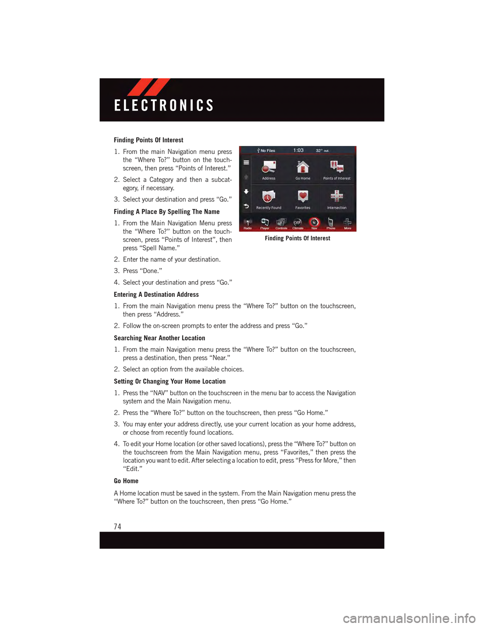
1. From the main Navigation menu press
the “Where To?” button on the touch-
screen, then press “Points of Interest.”
2. Select a Category and then a subcat-
egory, if necessary.
3. Select your destination and press “Go.”
Finding A Place By Spelling The Name
1. From the Main Navigation Menu press
the “Where To?” button on the touch-
screen, press “Points of Interest”, then
press “Spell Name.”
2. Enter the name of your destination.
3. Press “Done.”
4. Select your destination and press “Go.”
Entering A Destination Address
1. From the main Navigation menu press the “Where To?” button on the touchscreen,
then press “Address.”
2. Follow the on-screen prompts to enter the address and press “Go.”
Searching Near Another Location
1. From the main Navigation menu press the “Where To?” button on the touchscreen,
press a destination, then press “Near.”
2. Select an option from the available choices.
Setting Or Changing Your Home Location
1. Press the “NAV” button on the touchscreen in the menu bar to access the Navigation
system and the Main Navigation menu.
2. Press the “Where To?” button on the touchscreen, then press “Go Home.”
3. You may enter your address directly, use your current location as your home address,
or choose from recently found locations.
4. To edit your Home location (or other saved locations), press the “Where To?” button on
the touchscreen from the Main Navigation menu, press “Favorites,” then press the
location you want to edit. After selecting a location to edit, press “Press for More,” then
“Edit.”
Go Home
AHomelocationmustbesavedinthesystem.FromtheMainNavigationmenupressthe
“Where To?” button on the touchscreen, then press “Go Home.”
Finding Points Of Interest
ELECTRONICS
74
Page 77 of 164
Searching By Phone Number
1. From the main Navigation menu press
the “Where To?” button on the touch-
screen, press the “down” arrow to dis-
play the secondary selections, then
press “Phone Number.”
2. Enter the desired Phone Number and
follow the prompts.
Secondary Search Selections
From the main Navigation menu press the
“Where To?” button on the touchscreen,
then press the “down” arrow to display the
secondary search selections.
SelectionSelection Description
ExtrasVisit http://www.garmin.com/us/extras to addmore content to your device with purchasableand free downloads.
CitiesSelect a City within the current state to routeto that specific City Center.
RoutesLet’s you create and save your own routes withyour own destinations or points of interests.
Browse MapsLet’s you browse and select destinations fromthe Map.
CoordinatesEnter destination using its Geographical co-ordinates instead of an address.
Searching By Phone Number
ELECTRONICS
75
Page 78 of 164
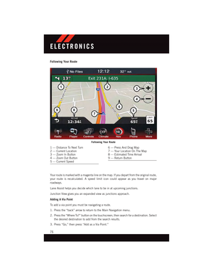
Following Your Route
Yo u r r o u t e i s m a r k e d w i t h a m a g e n t a l i n e o n t h e m a p . I f y o u d e p a r t f r o m t h e o r i g i n a l r o u t e ,
your route is recalculated. A speed limit icon could appear as you travel on major
roadways.
Lane Assist helps you decide which lane to be in at upcoming junctions.
Junction View gives you an expanded view as junctions approach.
Adding A Via Point
To a d d a v i a p o i n t y o u m u s t b e n a v i g a t i n g a r o u t e .
1. Press the “back” arrow to return to the Main Navigation menu.
2. Press the “Where To?” button on the touchscreen, then search for a destination. Select
the desired destination to add from the search results.
3. Press “Go,” then press “Add as a Via Point.”
Following Your Route
1—DistanceToNextTurn2—CurrentLocation3—ZoomInButton4—ZoomOutButton5—CurrentSpeed
6—PressAndDragMap7—YourLocationOnTheMap8—EstimatedTimeArrival9—ReturnButton
ELECTRONICS
76
Page 79 of 164

Taking A Detour
To t a k e a d e t o u r y o u m u s t b e n a v i g a t i n g a r o u t e .
•Press“Detour.”
NOTE:
If the route you are currently taking is the only reasonable option, the device might not
calculate a detour.
Traffic
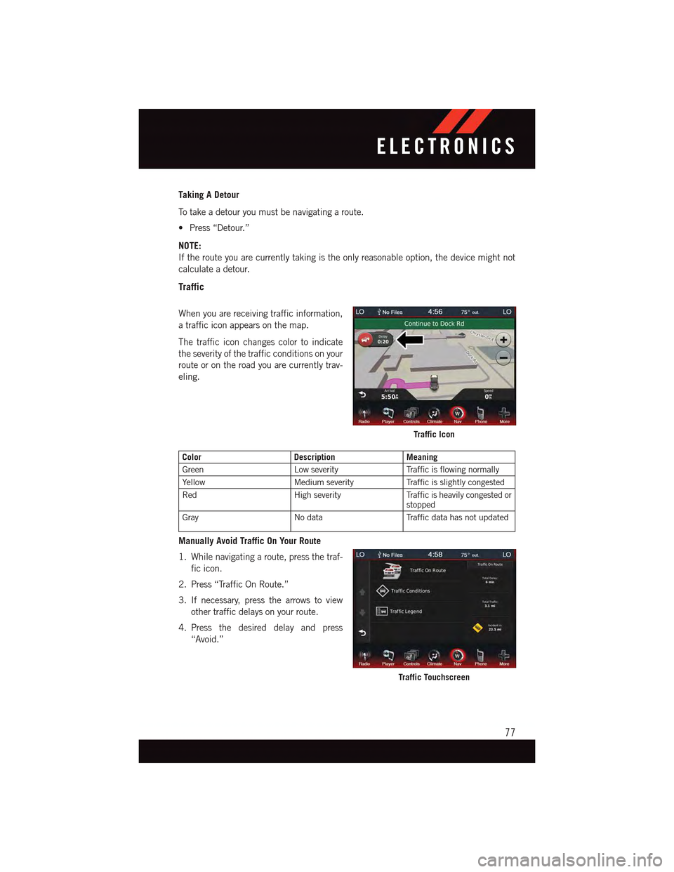
When you are receiving traffic information,
atrafficiconappearsonthemap.
The traffic icon changes color to indicate
the severity of the traffic conditions on your
route or on the road you are currently trav-
eling.
ColorDescriptionMeaning
GreenLow severityTr a f f i c i s f l o w i n g n o r m a l l y
Ye l l o wMedium severityTr a f f i c i s s l i g h t l y c o n g e s t e d
RedHigh severityTr a f f i c i s h e a v i l y c o n g e s t e d o rstopped
GrayNo dataTr a f f i c d a t a h a s n o t u p d a t e d
Manually Avoid Traffic On Your Route
1. While navigating a route, press the traf-
fic icon.
2. Press “Traffic On Route.”
3. If necessary, press the arrows to view
other traffic delays on your route.
4. Press the desired delay and press
“Avoid.”
Traffic Icon
Traffic Touchscreen
ELECTRONICS
77
Page 80 of 164
View The Traffic Map
The traffic map shows color-coded traffic flow and delays on nearby roads.
1. From the map, press the “traffic icon.”
2. Press “Traffic Map” to view the traffic incidents on a map.
Search For Traffic Delays
1. From the map, press the “traffic icon.”
2. Press “Traffic Search” to view a list of
traffic delays.
3. Press an item in the list to view delays on
the road.
4. If there is more than one delay, press the
“arrows” to view additional delays.
Traffic Search
ELECTRONICS
78