2014 MITSUBISHI MIRAGE change time
[x] Cancel search: change timePage 6 of 135

6
Disclaimers
Mitsubishi Motors will in no way be held
responsible for losses resulting from fire,
earthquake, tsunami, flood, or other natural
disasters; from actions of third parties; from
other accidents; or from inappropriate or
abnormal usage conditions utilized by the
customer, be said conditions deliberate or
unintentional.
There will be no indemnification for
alteration or loss of any information stored
upon this product (address book etc.) by
the customer or a third party resulting from
improper use of this product, the influence
of static electricity or electric noise, or at
the time of malfunction or repair or similar
circumstances. We recommend that you
create backups of important information as
a precautionary measure.
Some personal information (addresses
in address book, telephone numbers
etc.) input into this product may remain in
memory even if this product is removed. The
customer is responsible for proper handling
and management (including deleting) of
personal information to protect privacy when
handing this product over to anyone else or
disposing of it. Mitsubishi Motors will in no
way be held responsible.
Mitsubishi Motors will in no way be held
responsible for any collateral losses (loss
of business profits, alteration or loss of
recorded data) resulting from the usage or
inability to use this product. Please be aware that the map displayed
is from when the data was prepared, so
it may differ from current conditions. Also,
Mitsubishi Motors will in no way be held
responsible for any losses resulting from
map data inadequacies.
This product contains data on traffic
regulations, but due to changes in traffic
rules, this data may differ from the actual
traffic rules. Always obey the actual traffic
regulations. Also, Mitsubishi Motors will in
no way be held responsible for any losses
resulting from traffic accidents or traffic
rule violations due to traffic regulation data
inadequacies.
Returns, refunds, exchange, or conversion
for reasons of map data inadequacy or the
like are not possible. There may be times
when the map data does not match the
specific objective of the user. The contents
of the map data are subject to change
without notice. The map data may contain
wrong or missing characters, incorrect
locations etc.
The rule guidance and audio guidance,
for example when to turn, may sometimes
differ from the actual traffic signs or traffic
regulations. Always obey the actual traffic
signs and actual traffic regulations.
For the purpose of product improvement,
specifications and external appearance
may be subject to change without advance
notice. Accordingly, while the contents
of the User Manual may differ, please be
aware that returns, refunds, exchange, or
conversion are not possible. This User Manual explains details for
multiple vehicle models together. Depending
on the vehicle model, there may be
functions that may be described but not
available, or requirements for separately
purchased-products. Thank you for your
understanding.
Images and illustrations used in the
User Manual are either those used in
development, or used for explanations.
Please be aware that these may differ from
the actual images and illustrations used in
the product.
Please be aware that Mitsubishi Motors,
including after-sales service departments,
will in no way be held responsible for any
losses or detriment resulting from alteration
or loss of any information stored in this
product, including customer registration
information.
Before Use
205-0010-00_QY-7375M-A_EN.indb 6205-0010-00_QY-7375M-A_EN.indb 63/12/2013 9:57:13 AM3/12/2013 9:57:13 AM
Page 10 of 135

10
1. WARNINGS
AND SAFETY
INFORMATION
The navigation system helps you find your
way to your destination with a connected
GPS receiver. MMES does not transmit your
position; others cannot track you.
If you accept it when first using the
application, MMES collects usage information
and GPS logs that may be used for improving
the application and the quality and coverage
of maps. The data is processed anonymously;
no one will be able to track any personal
information. If you change your mind later,
you can enable or disable the log collection in
Settings (page 74).
It is important that you look at the display only
when it is safe to do so. If you are the driver of
the vehicle, we recommend that you operate
MMES before you start your journey. Plan the
route before your departure and stop if you
need to change the route. Some operations
are restricted while driving for safety.
You must obey the traffic signs and follow
the road geometry. If you deviate from the
recommended route, MMES changes the
instructions accordingly.
2. GETTING
STARTED
MMES is optimized for in-car use. You can
use it easily by tapping the screen buttons and
the map with your fingertips.
When using the navigation software for
the first time, an initial setup process starts
automatically. Do as follows:
1. Select the language and voice used for
voice guidance messages. Later you can
alter your selection via the Sound and
Warnings settings (page 66).
2. If needed, modify the settings. Later you
can alter your selection via the Regional
settings (page 73).
3. If needed, modify the default route
planning options. Later you can alter your
selection via the Route settings (page 68).
4. The initial setup is now complete. The
Configuration wizard can be restarted
later from the Settings menu (page 64).
After the initial setup process, the Navigation
menu appears and you can start using MMES.
205-0010-00_QY-7375M-A_EN.indb 10205-0010-00_QY-7375M-A_EN.indb 103/12/2013 9:57:14 AM3/12/2013 9:57:14 AM
Page 20 of 135

20
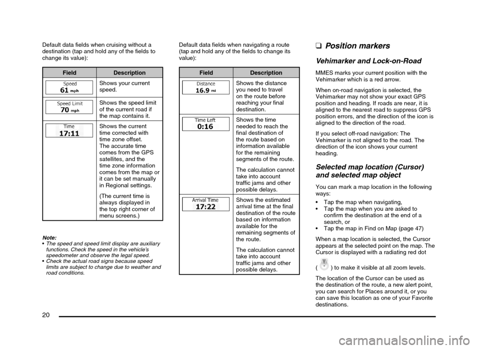
Default data fields when cruising without a
destination (tap and hold any of the fields to
change its value):
Field Description
Shows your current
speed.
Shows the speed limit
of the current road if
the map contains it.
Shows the current
time corrected with
time zone offset.
The accurate time
comes from the GPS
satellites, and the
time zone information
comes from the map or
it can be set manually
in Regional settings.
(The current time is
always displayed in
the top right corner of
menu screens.)
Note:
The speed and speed limit display are auxiliary
functions. Check the speed in the vehicle’s
speedometer and observe the legal speed.
Check the actual road signs because speed
limits are subject to change due to weather and
road conditions.
Default data fields when navigating a route
(tap and hold any of the fields to change its
value):
Field Description
Shows the distance
you need to travel
on the route before
reaching your final
destination.
Shows the time
needed to reach the
final destination of
the route based on
information available
for the remaining
segments of the route.
The calculation cannot
take into account
traffic jams and other
possible delays.
Shows the estimated
arrival time at the final
destination of the route
based on information
available for the
remaining segments of
the route.
The calculation cannot
take into account
traffic jams and other
possible delays.
qPosition markers
Vehimarker and Lock-on-Road
MMES marks your current position with the
Vehimarker which is a red arrow.
When on-road navigation is selected, the
Vehimarker may not show your exact GPS
position and heading. If roads are near, it is
aligned to the nearest road to suppress GPS
position errors, and the direction of the icon is
aligned to the direction of the road.
If you select off-road navigation: The
Vehimarker is not aligned to the road. The
direction of the icon shows your current
heading.
Selected map location (Cursor)
and selected map object
You can mark a map location in the following
ways:
Tap the map when navigating,
Tap the map when you are asked to
confirm the destination at the end of a
search, or
Tap the map in Find on Map (page 47)
When a map location is selected, the Cursor
appears at the selected point on the map. The
Cursor is displayed with a radiating red dot
(
) to make it visible at all zoom levels.
The location of the Cursor can be used as
the destination of the route, a new alert point,
you can search for Places around it, or you
can save this location as one of your Favorite
destinations.
205-0010-00_QY-7375M-A_EN.indb 20205-0010-00_QY-7375M-A_EN.indb 203/12/2013 9:57:15 AM3/12/2013 9:57:15 AM
Page 23 of 135

23
3D object types
MMES supports the following 3D object types:
Type Description
3D terrain 3D terrain map data shows changes in terrain, elevations or depressions in the land when you view the map in 2D, and
use it to plot the route map in 3D when you navigate. Hills and mountains are shown in the background of the 3D map, and
illustrated by color and shading on the 2D map.
Elevated roads Complex intersections and vertically isolated roads (such as overpasses or bridges) are displayed in 3D.
3D landmarks Landmarks are 3D artistic or block representations of prominent or well-known objects.
Elements of the active route
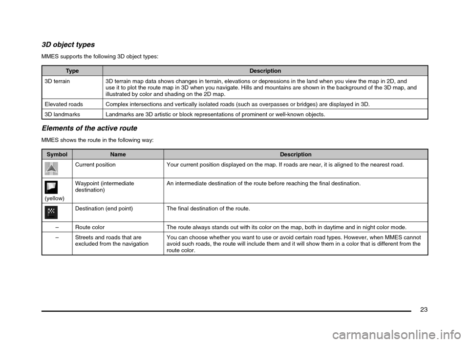
MMES shows the route in the following way:
Symbol Name Description
Current position Your current position displayed on the map. If roads are near, it is aligned to the nearest road.
(yellow)Waypoint (intermediate
destination)An intermediate destination of the route before reaching the final destination.
Destination (end point) The final destination of the route.
– Route color The route always stands out with its color on the map, both in daytime and in night color mode.
– Streets and roads that are
excluded from the navigationYou can choose whether you want to use or avoid certain road types. However, when MMES cannot
avoid such roads, the route will include them and it will show them in a color that is different from the
route color.
205-0010-00_QY-7375M-A_EN.indb 23205-0010-00_QY-7375M-A_EN.indb 233/12/2013 9:57:15 AM3/12/2013 9:57:15 AM
Page 52 of 135

52
4. You have the following options on this
screen (for detailed instructions on how to
use them, see the next chapter):
to edit the
route: to add or remove destinations or
change their sequence. You can also
set a route start point other than your
current location. This can be useful to
plan and save a future trip.
to display the
entire route on the map.
to bypass a
part of the route.
to delete the
active route.
to open a list
with more options like selecting from
route alternatives, changing route
parameters, simulating the route,
saving the active route or loading a
previously saved route.
to return to the
Navigation menu.
Modifying the route
When navigation is already started, there
are several ways to modify the active route.
The following sections show some of those
options.
qSelecting a new destination
when already having a route:
New Route, Waypoint or
Final Destination
If you already have a recommended route
and you select a new destination as described
in the above sections, the application will
ask you whether to start a new route, add
a new waypoint (intermediate destination)
to the route or append the newly selected
destination at the end of the current route.
to plan a new route to the
newly selected location. The previous
destination and waypoint(s) are deleted.
to add the newly selected
location as an intermediate destination to
your route. The other destinations of the
route remain intact.
Note:
The new waypoint is placed among destinations
to keep the route optimal. To decide where a
waypoint to appear, use the Edit Route feature.
to append the newly selected
destination at the end of the route. The
other destinations of the route remain
intact. The previous final destination is now
the last waypoint.
qSetting a new starting
position for the route
For normal navigation, all routes are planned
from the current position. In order to check
future routes, simulate them or see their
length in time and distance, you can turn
off the GPS receiver. Then you can set
the starting point of the route to a different
location than the current position.
1. If you are on the Map screen, tap
to return to the
Navigation menu.
2. In the Navigation menu, tap
.
205-0010-00_QY-7375M-A_EN.indb 52205-0010-00_QY-7375M-A_EN.indb 523/12/2013 9:57:22 AM3/12/2013 9:57:22 AM
Page 55 of 135

55
qChecking route alternatives
for an existing route
To recalculate the active route with a different
route planning method, you can modify
the Route settings. There is another way
to do this and to compare different route
alternatives with the same route planning
method. Do as follows:
1. If you are on the Map screen, tap
to return to the
Navigation menu.
2. In the Navigation menu, tap
.
3. Tap .
4. Tap .
5. You see the basic details of three route
alternatives with the selected route
planning method.
Tap any of them to see it on the map.
6. Or if you cannot find a good alternative,
tap
and scroll down for
routes with different routing methods.
7. Select one of the route alternatives then
tap and hold
for a few
seconds to return to the Map screen.
MMES recalculates the route. The orange
line now shows the new recommended
route.
qChanging the road types
used in route planning
To recalculate the active route with different
road type preferences, do as follows. These
changes can also be made in Settings (page
64).
1. On the Map screen, tap
and then
tap
.
2. Tap any of the listed road types to modify
the route. If needed, scroll the list for all
road types. You have the following options:
- You might need to
avoid freeways when you are driving
a slow car or you are towing another
vehicle.
- Charge roads are
pay roads where you can purchase
a pass or vignette to use the road for
a longer period of time. They can be
enabled or disabled separately from
toll roads.
205-0010-00_QY-7375M-A_EN.indb 55205-0010-00_QY-7375M-A_EN.indb 553/12/2013 9:57:23 AM3/12/2013 9:57:23 AM
Page 58 of 135

58
5. Tap to save the
changes to the alert point.
Watching the simulation
of the route
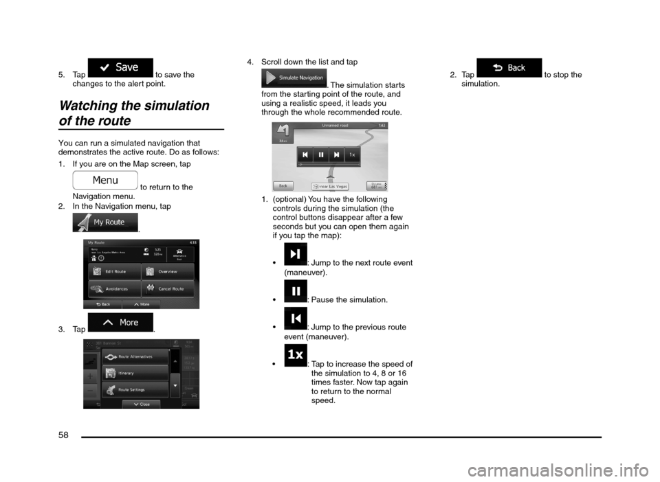
You can run a simulated navigation that
demonstrates the active route. Do as follows:
1. If you are on the Map screen, tap
to return to the
Navigation menu.
2. In the Navigation menu, tap
.
3. Tap
.
4. Scroll down the list and tap
. The simulation starts
from the starting point of the route, and
using a realistic speed, it leads you
through the whole recommended route.
1. (optional) You have the following
controls during the simulation (the
control buttons disappear after a few
seconds but you can open them again
if you tap the map):
: Jump to the next route event
(maneuver).
: Pause the simulation.
: Jump to the previous route
event (maneuver).
: Tap to increase the speed of
the simulation to 4, 8 or 16
times faster. Now tap again
to return to the normal
speed.2. Tap
to stop the
simulation.
205-0010-00_QY-7375M-A_EN.indb 58205-0010-00_QY-7375M-A_EN.indb 583/12/2013 9:57:23 AM3/12/2013 9:57:23 AM
Page 63 of 135

63
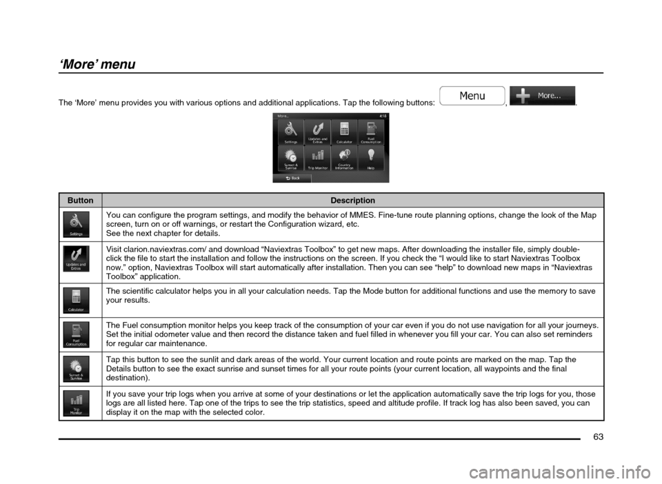
‘More’ menu
The ‘More’ menu provides you with various options and additional applications. Tap the following buttons: , .
Button Description
You can configure the program settings, and modify the behavior of MMES. Fine-tune route planning options, change the look of the Map
screen, turn on or off warnings, or restart the Configuration wizard, etc.
See the next chapter for details.
Visit clarion.naviextras.com/ and download “Naviextras Toolbox” to get new maps. After downloading the installer file, simply double-
click the file to start the installation and follow the instructions on the screen. If you check the “I would like to start Naviextras Toolbox
now.” option, Naviextras Toolbox will start automatically after installation. Then you can see “help” to download new maps in “Naviextras
Toolbox” application.
The scientific calculator helps you in all your calculation needs. Tap the Mode button for additional functions and use the memory to save
your results.
The Fuel consumption monitor helps you keep track of the consumption of your car even if you do not use navigation for all your journeys.
Set the initial odometer value and then record the distance taken and fuel filled in whenever you fill your car. You can also set reminders
for regular car maintenance.
Tap this button to see the sunlit and dark areas of the world. Your current location and route points are marked on the map. Tap the
Details button to see the exact sunrise and sunset times for all your route points (your current location, all waypoints and the final
destination).
If you save your trip logs when you arrive at some of your destinations or let the application automatically save the trip logs for you, those
logs are all listed here. Tap one of the trips to see the trip statistics, speed and altitude profile. If track log has also been saved, you can
display it on the map with the selected color.
205-0010-00_QY-7375M-A_EN.indb 63205-0010-00_QY-7375M-A_EN.indb 633/12/2013 9:57:24 AM3/12/2013 9:57:24 AM