Page 81 of 236
My Music Mode
Audio l
2-57
Info On/Info Off
Press the Menu
button ▶ Press
Info On .
The screen display can be set differently
depending on user selection.
When the title, artist, and album info are dis-
played, the button is changed to
Info Off
.
Press Info Off
to restore the previous
information display setting.
i Information
• The title, artist and album info are dis-
played only when such information is
recorded within the MP3 file ID3 tag.
Using Menus within the
List Screen
Moving between Lists
Press the List button ▶ Press ▲ ,
▼ .
If six (6) or more files or folders exist in
the same folder, the list will be displayed
across two or more pages.
Press the
▲
, ▼
cursor buttons to
quickly find the desired page.
Page 84 of 236
3-2
Please observe and comply with local traffic rules and regulations.
For your safety, some features cannot be operated while driving for your safety. Features that cannot be operated will be dis-
abled.
The route displayed for destination guidance is a reference and
the route guidance will take you to the vicinity of your destination
.
The highlighted route is not always; the shortest distance, the least
congested, and in some cases might, not be the fastest route.
Road, name, and POI information may not always been com- pletely updated. Some places may not include up to date infor-
mation.
The car position mark does not always indicate your exact loca-
tion. This system uses GPS information, various sensors, and
road map data to display the current position. However, errors in
displaying your location may occur if the satellite is transmitting
inaccurate signals or two or less satellite signals are being
received. Errors that occur in such conditions cannot be corrected.
The position of the vehicle within the navigation may differ from your actual location depending on various reasons, including
the satellite transmission state, vehicle state (driving location
and conditions), etc. Additionally, the car position mark may dif-
fer from the actual position if the map data is different from the
actual road landscape, such as changes due to the construction
of new roads. If such differences occur, driving for a short period
of time will automatically correct the position of the vehicle
through map matching or GPS information. (several minutes
may be necessary in certain cases)
Before Use
Precautions for Safe Driving
Page 85 of 236
Before Use
Navigation l
3-3
Operating the Navigation
The navigation can be operated via touch. Touch the correspond-
ing button on the screen to operate.
If the button does not respond, take your finger off the screen and try again.
When a button function is operating, the color of the selected button will be displayed differently.
To return to the previous screen, press the button.
Press the button to cancel functions that can be operated
on the current screen.
(Some functions may not be cancelled.)
i Information
• Buttons that cannot be operated will be disabled.
Page 86 of 236
3-4
About the Map
Some roads, site names, and facility infor-
mation may have changed after map data
update and may differ with actual road
conditions.
About Map Scale
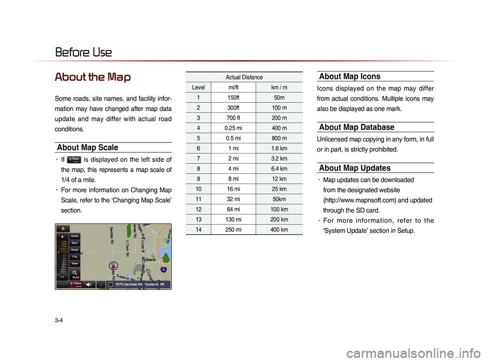
• If is displayed on the left side of
the map, this represents a map scale of
1/4 of a mile.
• For more information on Changing Map
Scale, refer to the ‘Changing Map Scale’
section.
Actual Distance
Level mi/ft km / m
1 150ft 50m
2 300ft 100 m
3 700 ft 200 m
4 0.25 mi 400 m
5 0.5 mi 800 m
6 1 mi 1.6 km
7 2 mi 3.2 km
8 4 mi 6.4 km
9 8 mi 12 km
10 16 mi 25 km
11 32 mi 50km
12 64 mi 100 km
13 130 mi 200 km
14 250 mi 400 km About Map Icons
Icons displayed on the map may differ
from actual conditions. Multiple icons may
also be displayed as one mark.
About Map Database
Unlicensed map copying in any form, in full
or in part, is strictly prohibited.
About Map Updates
• Map updates can be downloaded
from the designated website
(http://www.mapnsoft.com) and updated
through the SD card.
• F o r m o r e i n f o r m a t i o n , r e f e r t o t h e
‘System Update’ section in Setup.
Before Use
Page 89 of 236
Starting Navigation
Navigation l
3-7
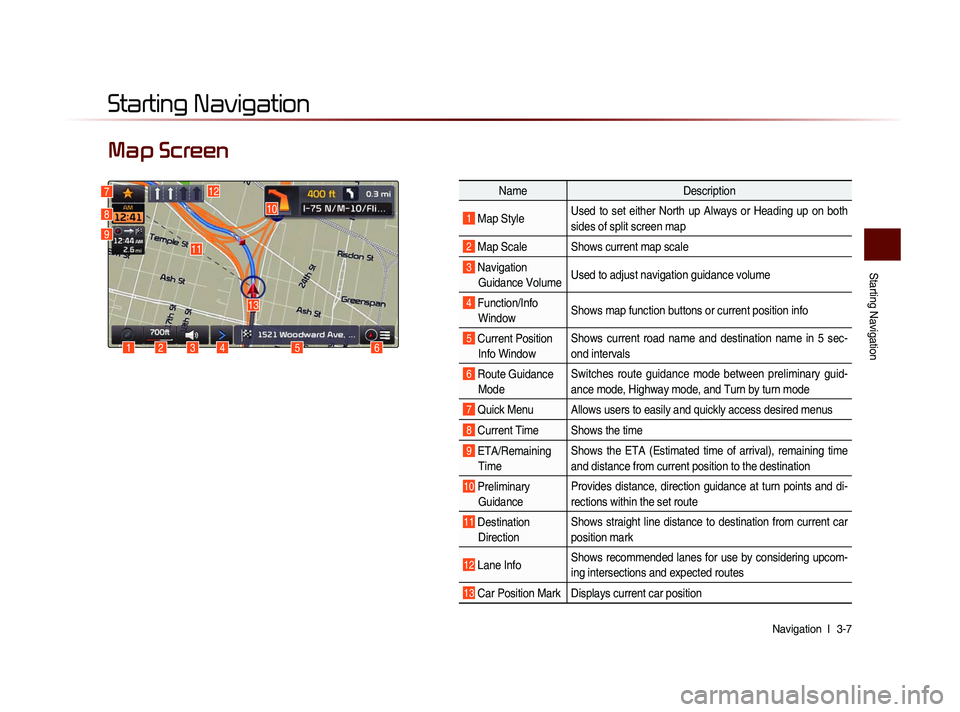
Map Screen
Starting Navigation
6
10
1234
13
127
8
9
Name Description
1 Map Style Used to set either North up Always or Heading up on both
sides of split screen map
2 Map Scale Shows current map scale
3 Navigation
Guidance Volume Used to adjust navigation guidance volume
4 Function/Info
Window Shows map function buttons or current position info
5 Current Position
Info Window Shows current road name and destination name in 5 sec-
ond intervals
6 Route Guidance
Mode Switches route guidance mode between preliminary guid-
ance mode, Highway mode, and Turn by turn mode
7 Quick Menu Allows users to easily and quickly access desired menus
8 Current Time Shows the time
9 ETA/Remaining
Time Shows the ETA (Estimated time of arrival), remaining time
and distance from current position to the destination
10 Preliminary
Guidance Provides distance, direction guidance at turn points and di-
rections within the set route
11 Destination
Direction Shows straight line distance to destination from current car
position mark
12 Lane Info
Shows recommended lanes for use by considering upcom-
ing intersections and expected routes
13 Car Position Mark Displays current car position
5
11
Page 90 of 236
3-8
Initial Screen
Press the Agree button to display the
most recently used mode.
If Audio mode is used with the navigation
turned on, navigation guidance will be
provided in the background. If you turn the
ignition on, then the most recently played
mode will restart.
i Information
• Once the vehicle ignition is turned on, the
User Warning screen will always be displayed.
Make sure to carefully read the warning page
as it contains important information related to
system operations while driving.
Current Position
Press the MAP
VOICE key or the button
displayed at the upper right side in some
map conditions to display the map of the
current position and the neighboring area.
i Information
• When riding in a new car or after replacing
the battery terminal, the car position mark
may at first appear at a different location.
• Even if the car position mark on the map
i s d i f f e r e n t , m a p m a t c h i n g a n d G P S
coordinates are utilized to automatically
update the current position. It may take
up to several minutes to find your current
position.
Map Display Settings
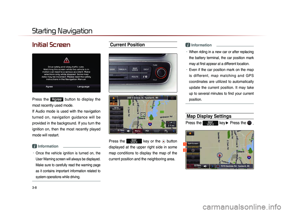
Press the MAP
VOICE key ▶ Press the
.
Starting Navigation
1
2
Page 91 of 236
Starting Navigation
Navigation l
3-9
This button is used to set map screen
related options, such as Split screen,
H e a d i n g - U p /N o r th U p , a n d L e ft/R i g h t
screen display.
Name Description
1 Split Screen/
Single ScreenSelect between Split Screen
or Single Screen Map
2 Heading-Up/
North-Up Display Map in Vehicle Trav-
eling Direction (Heading-Up)
or North-Up direction
i Information
• The Heading-Up/North-Up, 2D, and map
scale adjustments can be used when
using Split Screen map.
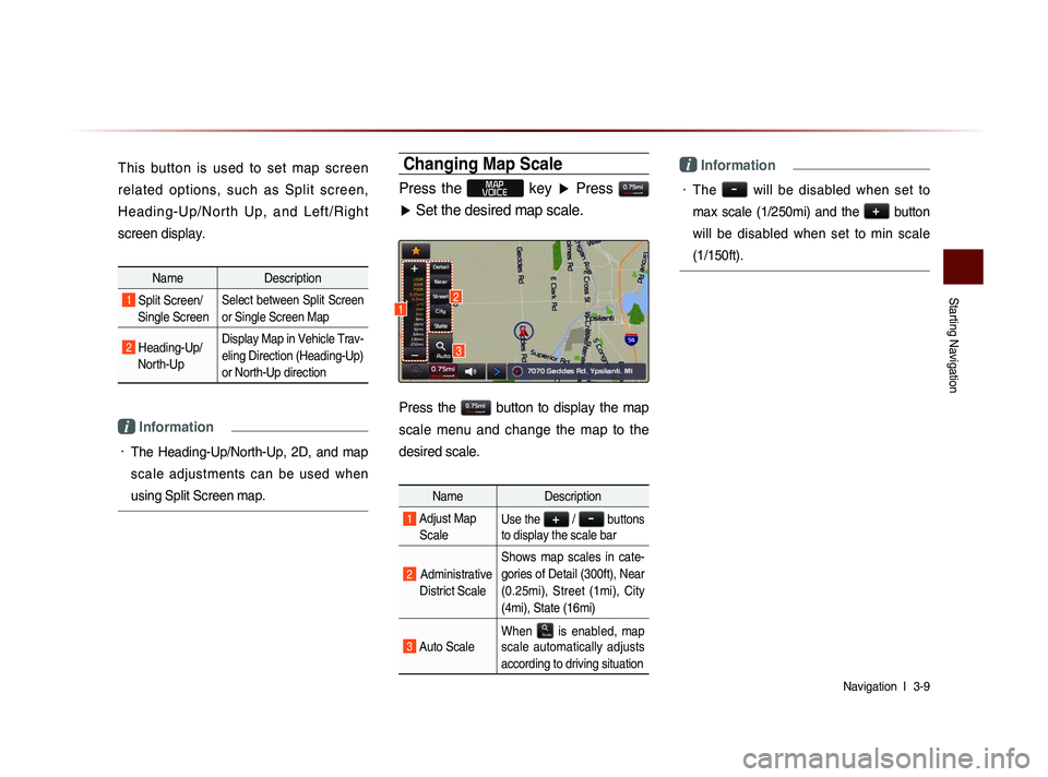
Changing Map Scale
Press the MAP
VOICE key ▶ Press
▶ Set the desired map scale.
Press the button to display the map
scale menu and change the map to the
desired scale.
Name Description
1 Adjust Map
ScaleUse the + / - buttons
to display the scale bar
2 Administrative
District Scale Shows map scales in cate-
gories of Detail (300ft), Near
(0.25mi), Street (1mi), City
(4mi), State (16mi)
3 Auto Scale
When
is enabled, map
scale automatically adjusts
according to driving situation
i Information
• The - will be disabled when set to
max scale (1/250mi) and the
+
button
will be disabled when set to min scale
(1/150ft).
3
12
Page 92 of 236
3-10
Map Menu
Press the > button ▶ Press Menu
button.
Features frequently used within the map
screen, such as
Set as Destination ,
Add Waypoint , View Destination ,
Cancel Route , Call , and Details are
displayed.
i Information
• If the screen is scrolled, then the top menu is
changed to the
Set as Destination button.
• If you have already set a destination, then the
top button will change to the
Recalculate
button.
Adjusting Navigation Volume
Press the button ▶ Adjust volume.
Press the button. The volume menu
is displayed and allows you to adjust the
navigation voice guidance volume.
The volume can be adjusted from 0~45
through the
+ / - button.
Press the
Mute button to turn off the
sound.
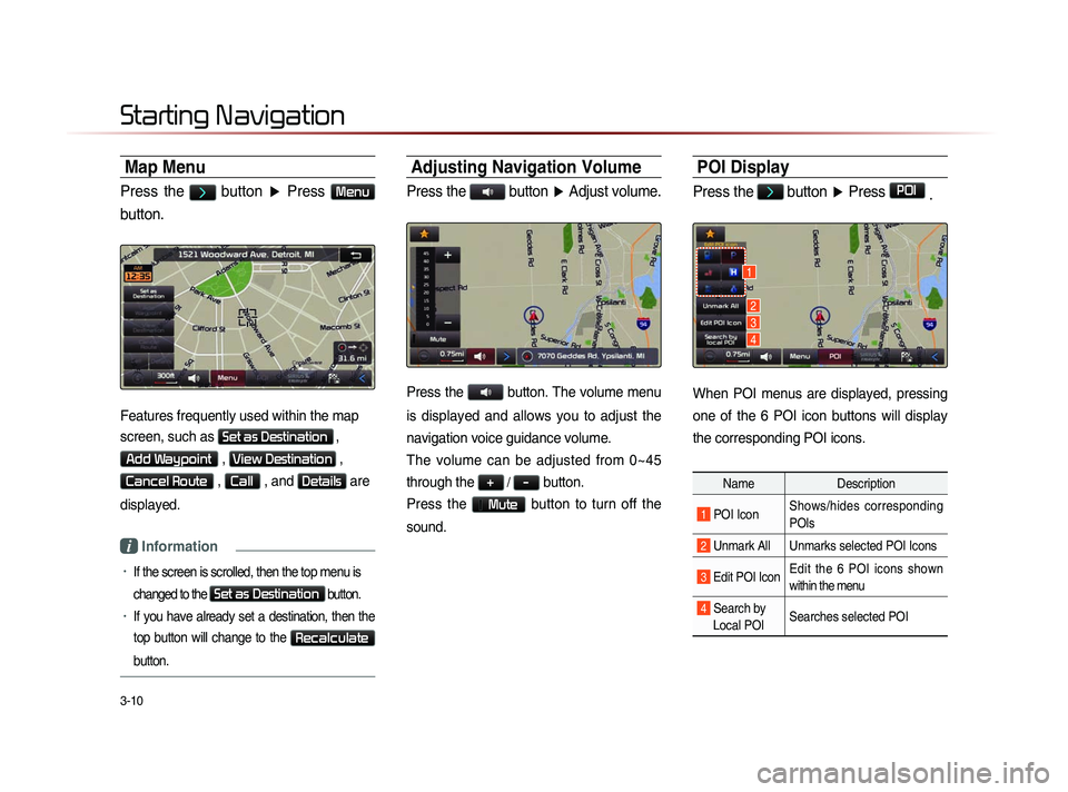
POI Display
Press the > button ▶ Press POI
.
When POI menus are displayed, pressing
one of the 6 POI icon buttons will display
the corresponding POI icons.
Name Description
1 POI IconShows/hides corresponding
POIs
2 Unmark All Unmarks selected POI Icons
3 Edit POI Icon Edit the 6 POI icons shown
within the menu
4 Search by
Local POI Searches selected POI
Starting Navigation
1
2
3
4