Page 121 of 167
*
120
NoteOptions that are not available due to your preset criteria cannot be selected
(these are greyed out in the display).Deleting a route– Press the Memory control button in")
Navigation (NAV)*
120
NoteOptions that are not available due to your preset criteria cannot be selected
(these are greyed out in the display).Deleting a route– Press the Memory control button in the navigation menu.
– Select Delete route .
– Select the route that you want to delete from the list of names.
–Confirm Are you sure you want to delete the route? with Ye s. The
selected route is deleted.Route control buttonRoute with/without stopover
Only the route guidance mode that is not currently active is shown
on the display as available.
–Press the Route control button in the navigation menu.
– If you would like to visit stopovers on the way to your final desti- nation, select Route with stopover ⇒ fig. 142 and enter your
driving route ⇒fig. 143with a maximum of 3 stopovers and your
final destination ⇒page 106.
– Otherwise, select Route without stopover and enter your final
destination (direct navigation) ⇒page 104.The navigation system remains in the mode which is currently set until you
change it. For example, if you have selected the mode Route with stopover for
a journey which you have completed, the navigation will stay in this mode
until you manually select the mode Route without stopover .
Route with stopover
Select this option to be guided to your final destination with stopovers.
You can also select special destinations as stopover destinations
⇒ page 110.
Fig. 142 Navigation
system: Route with stop-
over
Fig. 143 Navigation
system: Route planned
media_systemE_EN.book Seite 120 Montag, 21. September 2009 1:48 13
Page 122 of 167
*121
Operating
RADIO, MEDIA (audiovisual
systems)
NAME, TEL
NAV, INFO
CAR, SETUP
Stopovers already entered can be deleted, changed or moved. You can also
drive to them immediately �")
Navigation (NAV)*121
Operating
RADIO, MEDIA (audiovisual
systems)
NAME, TEL
NAV, INFO
CAR, SETUP
Stopovers already entered can be deleted, changed or moved. You can also
drive to them immediately ⇒
page 119.
Route without stopover
Select this option to navigate directly to your destination.
Note
If you switch to the navigation function and you are shown the menu for Route
planning ⇒ page 120, fig. 143 , you are in Route guidance with stopover. If
you would like to navigate directly to a final destination, select and confirm
Route without stopover in the Route function menu.Route list– Press the Route control button in the navigation menu.
–Select Route list ⇒ page 120, fig. 142 . The route will be shown
in detail ⇒fig. 144 .The route list contains the following information:
•Notes on the route•Distances•Street names•City namesNote
If route guidance is not activated, Route list will be greyed out.Route criteria
Route calculation depends on the route criteria selected.–Press the Route control button in the navigation menu.
– Select Route criteria ⇒ page 120, fig. 142 .
– Select the desired route criteria ⇒fig. 145 .During route guidance, route criteria can be changed as desired and the route
will be recalculated.
Fig. 144 Navigation
system: route
Fig. 145 Navigation
system: Listing of the
possible route criteria
media_systemE_EN.book Seite 121 Montag, 21. September 2009 1:48 13
Page 123 of 167
*
122The following route criteria are available:
Dynamic navigation
Select on or off. The dynamic navigation function optimises a route plan by
using the most current TMC traffic me")
Navigation (NAV)*
122The following route criteria are available:
Dynamic navigation
Select on or off. The dynamic navigation function optimises a route plan by
using the most current TMC traffic messages to recalculate routes and avoid
traffic jams etc.
For more information about the dynamic navigation function, please refer to
⇒ page 100.
Route options
If you select fast , the system will calculate a route that takes you to your desti-
nation as quickly as possible. If you select short the system will calculate a
route that is as short as possible.
Motorway
Comprising the options include or exclude from the route. By choosing avoid
Motorway , the system will attempt to plan a route without motorway
sections. However, if the final destination is more than 300 km away,
motorway sections will not be avoided.
Ferry
Comprising the options include or exclude from the route. By choosing avoid
Ferry , the system will attempt to plan a route without using ferry connections.
Toll road
Comprising the options include or exclude from the route. By choosing avoid
toll road , the system will attempt to plan a route without using toll roads.
Time-restricted road
Comprising the options include or exclude from the route. If you select avoid
time-restricted road the system will try to exclude such roads when calcu-
lating the route. However, only those roads stored on the navigation DVD as
time-restricted roads can be avoided.
When avoid has been selected these roads will be avoided regardless of the
time of day and the day of the week. This means that roads which are blocked at night and therefore listed as time-restricted, will always be excluded from
the route if this option is activated.
Season-restricted road
Comprising the options include
or exclude from the route. If you select avoid
season-restricted road the system will try to exclude such roads when calcu-
lating the route. However, only those roads stored on the navigation DVD as
season-restricted roads can be avoided.
When avoid has been selected these roads will be avoided regardless of the
season. If a road is, for example, closed in winter, it will be excluded in the
route calculation even during the summer months.
Motorrail
Comprising the options include or exclude from the route. When you have
selected avoid Motorrail , the system will attempt to plan a route without
using Motorrail sections. However, only those sections stored on the naviga-
tion DVD as Motorrail can be avoided.
Note
•If you would like to avoid a route criterion but this makes route guidance
impossible, this criterion is still included when calculating the route (e.g.
ferry to Ireland). A voice message will inform you of this.•If the navigation does not display a detour route, although dynamic navi-
gation function is on and a traffic jam has been reported on the planned
route, this is because the estimated time required for the detour is longer
than the estimated time required for remaining on the route with the traffic
jam.
media_systemE_EN.book Seite 122 Montag, 21. September 2009 1:48 13
Page 124 of 167
*123
Operating
RADIO, MEDIA (audiovisual
systems)
NAME, TEL
NAV, INFO
CAR, SETUP
Avoiding route sectionsThis function is available once you start travelling on a calculated
route.
�")
Navigation (NAV)*123
Operating
RADIO, MEDIA (audiovisual
systems)
NAME, TEL
NAV, INFO
CAR, SETUP
Avoiding route sectionsThis function is available once you start travelling on a calculated
route.
– Press the Route control button in the navigation menu.
–Select Avoid route from here ⇒ page 120, fig. 142 .
– Turn the control knob to select the appropriate section on the current route.
– Confirm the section to be avoided by pressing the control knob.The navigation system will attempt to calculate an alternative route plan for
the section you want to avoid.
If you stop and then restart the route guidance, it will be necessary to re-enter
the route section to avoid.
Note
•If the function Avoid route from here is greyed out and the navigation
system is not able to offer an alternative route, this indicates that there is no
suitable detour.•If you do not follow the calculated route or if you leave the route, the
system will automatically calculate a new route plan based on your current
location.
Map control buttonIntroduction
There are various displays for maps and information with
different options possible.Map representation:•Map and information representation during route guidance with inactive
side menu ⇒ page 124•Map representation with active side menu ⇒ page 125Note
•If the route or sections of the route are highlighted in a light blue colour
⇒ fig. 146 in the map display, this indicates that information regarding
this road or route section may be incomplete. For example, it could be a one-
way street or a pedestrian zone, etc. Take the signs found on the route into
account and respect traffic regulations.•You will see directional arrows in the instrument panel display
⇒ page 101 or ⇒page 101 which inform you of the route guidance
directions.
Fig. 146 Navigation: Map
display with a section of
the route highlighted light
blue
A1
media_systemE_EN.book Seite 123 Montag, 21. September 2009 1:48 13
Page 125 of 167
*
124Map and information displayThe figures ⇒fig. 147 and ⇒fig. 148 show the possible types of information
in the map display:
Map orientation
Map scale
Estimated distance to t")
Navigation (NAV)*
124Map and information displayThe figures ⇒fig. 147 and ⇒fig. 148 show the possible types of information
in the map display:
Map orientation
Map scale
Estimated distance to the next destination/stopover
Estimated time of arrival at the next destination/stopover
Route (marked blue)
Examples of selected map contents ⇒page 134
Motorway exits are shown for a scale ranging from 500 m to 6 km Vehicle symbol
Turn list inserted in the Setup menu
⇒page 135
The map display modes can be changed ⇒page 131.
Traffic jam announcements are shown automatically, showing the traffic jam
symbol on the map and marking the roads affected. If the dynamic navigation
⇒ page 121 is activated, the route will, if possible, be recalculated in order
to avoid the traffic jam.
You can select a destination directly from the map using the cursor
⇒ page 128.
You will see directional arrows in the instrument panel display ⇒page 101
which inform you of the route guidance directions.
The degrees of latitude and longitude ⇒page 125, fig. 149 and the current
altitude of the vehicle are shown when the map is displayed with the side
menu activated.
Note
A tunnel or underpass is displayed on the map as a broken line up to a scale
of 750 m.
Fig. 147 Navigation:
Example of map represen-
tationFig. 148 Navigation
system: Map representa-
tion with activated turn
list
A1A2A3A4A5A6A7
A8A9
media_systemE_EN.book Seite 124 Montag, 21. September 2009 1:48 13
Page 126 of 167
*125
Operating
RADIO, MEDIA (audiovisual
systems)
NAME, TEL
NAV, INFO
CAR, SETUP
Map representation with active side menu
The map representation can be changed through the active
sid")
Navigation (NAV)*125
Operating
RADIO, MEDIA (audiovisual
systems)
NAME, TEL
NAV, INFO
CAR, SETUP
Map representation with active side menu
The map representation can be changed through the active
side menu.– Press the Map control button in the navigation menu.
– Press the control knob to switch to the side menu.
– Select the desired submenu item by rotating and pressing the control knob and make your changes.
– Press the ⇒page 9 button to leave the map side menu.If you have activated the zoom function ⇒page 126 or the cursor
⇒ page 129 in the active side menu, you have to press the button
twice to leave the map side menu.
After you have activated the side menu, you are shown information
(city/street names and longitude/latitude) for the position you reached at the
time of activation. The following functions can be carried out using the active map side menu:
Note
Any setting adjustments you make using the active side menu are not kept
after deactivation. You can enter permanent settings for the map display
using navigation setup
⇒page 131.
Fig. 149 Navigation
system: Map representa-
tion with active side menu
RETURN
RETURN
Legend
FunctionMap orientation
⇒page 126Map scale
⇒page 126Map position menu
⇒page 128Activation of map cursor
⇒page 129Scroll
⇒page 129 FunctionPresentation of map cursor
⇒page 129Vehicle symbol
A1A2A3A4A5A6A7
media_systemE_EN.book Seite 125 Montag, 21. September 2009 1:48 13
Page 127 of 167
*
126Map orientation
Inside side menu activation you can switch back and forth
between direction of travel (Vehicle) and North.– Press the Map control button in the navigation menu")
Navigation (NAV)*
126Map orientation
Inside side menu activation you can switch back and forth
between direction of travel (Vehicle) and North.– Press the Map control button in the navigation menu.
– Press the control knob to switch to the map side menu.
– Rotate the control knob to switch to the first map menu item ⇒fig. 150 .
– By pressing the control knob, you can switch back and forth between orientation North ⇒ fig. 150 and Ve hicle . The changed
setting remains for the time the side menu is active.
– Press the ⇒page 9 button to leave the map side menu.When you change the map orientation with the side menu active, this map
orientation remains only for the time the side menu remains active. After the
side menu is deactivated, the orientation entered is Setup becomes active
again ⇒page 132. By selecting
North the map is oriented to the North ⇒ fig. 150. The vehicle
always remains in the centre of the display.
Select vehicle , the vehicle symbol is oriented pointing North. The map will
then rotate around the vehicle symbol.
Zoom mapChanging scale with inactive side menu:
–Press the Map control button in the navigation menu.
Fig. 150 Navigation: Map
orientation North in the
active side menu
A1
RETURN
Fig. 151 Navigation:
Adjusting zoom with inac-
tive side menuFig. 152 Navigation
system: Adjusting zoom
in active side menu
media_systemE_EN.book Seite 126 Montag, 21. September 2009 1:48 13
Page 128 of 167
*127
Operating
RADIO, MEDIA (audiovisual
systems)
NAME, TEL
NAV, INFO
CAR, SETUP
– Rotate the control knob counterclockwise to zoom in on the map
(smaller scale, detail view) or
�")
Navigation (NAV)*127
Operating
RADIO, MEDIA (audiovisual
systems)
NAME, TEL
NAV, INFO
CAR, SETUP
– Rotate the control knob counterclockwise to zoom in on the map
(smaller scale, detail view) or
– Rotate the control knob clockwise to zoom out of the map (larger
scale, more overview). The scale ⇒ page 126, fig. 151 is
shown in the side menu.
Changing scale with active side menu:
– Press the Map control button in the navigation menu.
– Press the control knob to switch to the map side menu.
– Rotate the control knob to the second menu item.
– Press the control knob to activate the map menu item Zoom (white highlight) ⇒page 126, fig. 152 .
– Rotate the control knob counterclockwise to zoom in on the map
(smaller scale, detail view) or
– Rotate the control knob clockwise to zoom out of the map (larger
scale, more overview). The scale ⇒ page 126, fig. 152 is
shown in the side menu.
– Press the ⇒page 9 button to exit the zoom mode.The scale can be set from 50 m to 600 km.
When you change the scale with the side menu active, the change will only
apply for as long as the side menu is active.
By pressing the button once, you leave Zoom mode and can use
other map menu items. Press the button again to deactivate the
active side menu.
The scales recommended for driving are:
•3.5 km on motorways•750 m on secondary roads•200 m in citiesNote
If you have activated auto intersection zoom ⇒page 137 and have selected
the map type destination, current position or current position 3D
⇒ page 133 the map scale will zoom in automatically at junctions and at turn
points.
A1
A2
A2
RETURNRETURN
RETURN
media_systemE_EN.book Seite 127 Montag, 21. September 2009 1:48 13
 1
1 2
2 3
3 4
4 5
5 6
6 7
7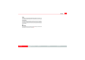 8
8 9
9 10
10 11
11 12
12 13
13 14
14 15
15 16
16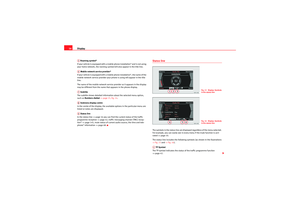 17
17 18
18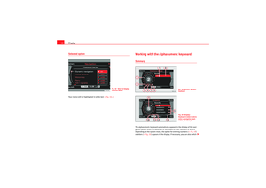 19
19 20
20 21
21 22
22 23
23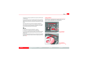 24
24 25
25 26
26 27
27 28
28 29
29 30
30 31
31 32
32 33
33 34
34 35
35 36
36 37
37 38
38 39
39 40
40 41
41 42
42 43
43 44
44 45
45 46
46 47
47 48
48 49
49 50
50 51
51 52
52 53
53 54
54 55
55 56
56 57
57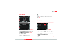 58
58 59
59 60
60 61
61 62
62 63
63 64
64 65
65 66
66 67
67 68
68 69
69 70
70 71
71 72
72 73
73 74
74 75
75 76
76 77
77 78
78 79
79 80
80 81
81 82
82 83
83 84
84 85
85 86
86 87
87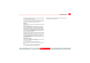 88
88 89
89 90
90 91
91 92
92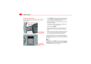 93
93 94
94 95
95 96
96 97
97 98
98 99
99 100
100 101
101 102
102 103
103 104
104 105
105 106
106 107
107 108
108 109
109 110
110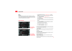 111
111 112
112 113
113 114
114 115
115 116
116 117
117 118
118 119
119 120
120 121
121 122
122 123
123 124
124 125
125 126
126 127
127 128
128 129
129 130
130 131
131 132
132 133
133 134
134 135
135 136
136 137
137 138
138 139
139 140
140 141
141 142
142 143
143 144
144 145
145 146
146 147
147 148
148 149
149 150
150 151
151 152
152 153
153 154
154 155
155 156
156 157
157 158
158 159
159 160
160 161
161 162
162 163
163 164
164 165
165 166
166