Page 10 of 174
 and
from GPS (Global Positioning System) satel-
lite")
WHA T IS A NA VIGA TION
SYSTEM?
ABOUT THE NAVIGATION SYS-
TEM
This navigation system combines the data ob-
tained from the vehicle (by gyro sensor) and
from GPS (Global Positioning System) satel-
lites to calculate the current location of the ve-
hicle. This position is then displayed on the
screen, allowing route guidance to a destina-
tion.
WHA T IS GPS (GLOBAL PO-
SITIONING SYSTEM)?
GPS is a system developed and operated by the
U.S. Government, covering the entire planet.
This navigation system receives three or more
different radio signals from NAVST AR (GPS
satellites), orbiting the earth 13,049 miles
(21,000 km) above ground. The data from dif-
ferent sets of signals will be trigonometrically
calculated to obtain the position of the vehicle.INFO:
The tracking center in the U.S. controls signals
transmitted from GPS satellites. This control
sometimes results in reduced accuracy or no
signal received at all in accordance with gov-
ernment requirements.
ACCURACY OF POSITIONING
The color of the GPS Indicatoron the up-
per left corner of the screen indicates position-
ing as follows:
�Green: Positioning is possible and accurate
�Y ellow: Positioning is possible but accu-
racy is minimal.
�Gray: Positioning is not possible
INV1441
HOW DOES THE NISSAN NAVIGATION SYSTEM WORK?
2-2
Page 11 of 174

INFO:
For approximately 3 or 4 minutes after system
startup, the GPS indicator
remains gray ,
even if accurate positioning is possible.
POSITIONING ADJUSTMENT
When the system judges that the vehicle po-
sition information is not accurate based on ve-
hicle speed and gyro sensor data calculations,
the system will adjust the vehicle position in-
formation using GPS signals.
RECEIVING SIGNALS FROM
GPS SATELLITES
Sometimes, satellite reception is weak. The fol-
lowing are places where signals tend to be
weak:
�Inside tunnels and parking lots in structures
�Areas with numerous tall buildings
�Under multi-layered highways
�In a dense forestVehicles in these areas may not receive GPS
signals (Indicator color: gray).
INFO:
The antenna for GPS is located in the instru-
ment panel.Do not place any objects, es-
pecially mobile phones or transceivers,
on the instrument panel. Because the
strength of the GPS signal is approximately
one billionth of that of TV waves, phones and
transceivers will decrease the strength or may
totally disrupt the signals.
DISPLAY OF GPS INFORMA-
TION
This system displays GPS information.
Please refer to “GPS information display” on
page 11-13.NOTE:
Directional guidance provided by the
navigation system does not take carpool
lane driving into consideration, espe-
cially when carpool lanes are separated
from other road lanes.
HOW DOES THE NISSAN NAVIGATION SYSTEM WORK?
2-3
Page 14 of 174

satel")
ROUTE GUIDANCE
The main feature of the NISSAN Navigation
System is Visual and Audio Route Guidance in
selected detailed map coverage areas. Utilizing
a network of GPS (Global Positioning System)
satellites, the NISSAN Navigation System
tracks your location on the map and directs you
where you want to go.
Once you program a destination covered by a
detailed map, the NISSAN Navigation System
will determine a route from your current loca-
tion to your destination. The moving map dis-
play and turn-by-turn voice commands help
the driver determine upcoming turns.
This feature can be especially helpful in finding
unfamiliar locations or businesses. The system
may be unable to set a destination and/or cal-
culate distance when a destination is outside
a detailed map coverage area. Additionally , au-
dio route guidance may not be available if the
destination is outside a detailed map coveragearea. For more information on how to program
a destination, please refer to section 5.
POINT OF INTEREST (POI)
DIRECTORY
The NISSAN Navigation System offers an ex-
tensive Point of Interest directory in detailed
map coverage areas. This directory includes a
wide variety of destinations ranging from gas
stations, A TMs, and restaurants to casinos, ski
resorts, shopping centers and businesses. By
accessing the Point of Interest directory , you
can search for addresses and phone numbers
for a destination, and with a press of a button,
the NISSAN Navigation System will calculate a
route to the destination.
The Point of Interest directory offers many
uses. For example, the directory can be sorted
by the various types of restaurants near your
current location. If you need an A TM or gas
station, the NISSAN Navigation System canpoint you to the closest one or the closest one
of your favorite brand.
For more information on how to use the Point
of Interest directory , please refer to section 6.ADDRESS BOOK
Using the Address Book feature, you will have
the ability to store up to 50 locations in detailed
map coverage areas into a personal directory .
This is especially useful for frequently visited
locations, such as your clients, relatives, or
friends. The Address Book feature will provide
you with easy access to these frequently visited
locations when setting them as your destina-
tion.
For more information on how to use your ad-
dress book, please refer to section 7.
A VOID AREA
By using the Avoid Area feature, you can iden-
tify areas or freeways that you would like the
NISSAN Navigation System to avoid when
WHAT FEATURES ARE AVAILABLE ON THE NISSAN NAVIGATION SYSTEM?
3-2
Page 141 of 174
3. Select theT racking On/Off key .
4. Select the
On key .5. Press the MAP button.
The location of the vehicle will be displayed.
INFO:
�Y ou can select the
On key to display the
indication marks (�), and the
Off key to
stop displaying them.
�The indication marks (�) may be spaced
differently , according to the scale of the
map.
�If you reset the current vehicle location, theindication marks (�) will be cleared.
GPS INFORMA TION DIS-
PLA Y
The following GPS information will be dis-
played on the screen: latitude, longitude, alti-
tude, signal reception, and satellite locations.
1. Press the SETTING button.
2. Select the
Navigation key on the [SET -
TINGS] screen.
INV1716
INV1717
INV1718
INV1466
HOW DO I ADJUST THE DISPLAY?
11-13
Page 142 of 174
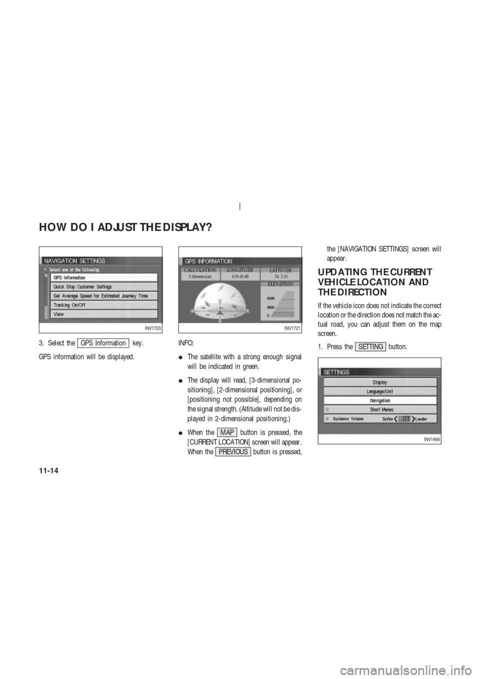
3. Select theGPS Information key .
GPS information will be displayed.INFO:
�The satellite with a strong enough signal
will be indicated in green.
�The display will read, [3-dimensional po-
sitioning], [2-dimensional positioning], or
[positioning not possible], depending on
the signal strength. (Altitude will not be dis-
played in 2-dimensional positioning.)
�When the MAP button is pressed, the
[CURRENT LOCA TION] screen will appear .
When the PREVIOUS button is pressed,the [NAVIGA TION SETTINGS] screen will
appear .
UPDA TING THE CURRENT
VEHICLE LOCA TION AND
THE DIRECTION
If the vehicle icon does not indicate the correct
location or the direction does not match the ac-
tual road, you can adjust them on the map
screen.
1. Press the SETTING button.
INV1720INV1721
INV1466
HOW DO I ADJUST THE DISPLAY?
11-14