Page 27 of 174

T racking On/Offkey:
Y ou can choose whether to display the path
from the start to the current position.
Please refer to “Displaying the track” on page
11-12.
Easy Mode — when the
Short Menuskey is selected
Viewkey:
Same as in Expert Mode.
Headingkey:
Same as in Expert Mode.
HOW TO USE THEDESTBUT-
TON
Sets destinations (final destination and
waypoints) to search for a route.
This will activate various navigational func-
tions.
WARNING
For safety , some of the functions on
the menu will be disabled while the
vehicle is moving. T o use the tempo-
rarily disabled functions, park the ve-
hicle in a safe place and shift to P or
N, and set the parking brake.
�
Address Bookkey:
Use this category item if you want to go to
places stored in the address book.
Please refer to “Setting with the
Address Book key” on page 5-3.
�
Previous Dest.key:
Y ou can choose destinations from the last 10
destinations set.
For details, please refer to “Setting with the
Previous Dest. key” on page 5-5.
INV1452
INV1453
HOW DO I OPERATE THE NISSAN NAVIGATION SYSTEM?
4-11
Page 28 of 174
.
Please refer to “Setting with the
Address/Street key” on page 5-6")
�Address/Streetkey:
Use this category item if you know the city
name, street name and house number of the
destination (waypoints).
Please refer to “Setting with the
Address/Street key” on page 5-6.
�
Intersectionkey:
Sets a destination using the intersection of 2
streets.
Please refer to “Setting with the
Intersection
key” on page 5-12.
�
Point of Interest (POI)key:
Use this category item if you want to go to a
restaurant, hotel, gas station or other facility .
Please refer to “Setting with the
Point of Interest (POI) key” on page 6-2.
�
Citykey:
Sets the destination (waypoint) on the mapscreen of the area around the input city .
Please refer to “Setting with the
City key” on
page 5-18.
�
Phone Numberkey:
Use this category item when the destination
phone number is known.
Please refer to “Setting with the
Phone Number key” on page 5-22.
�
Mapkey:
Use this category item if you want to choose
the place directly on the map display .
Please refer to “Setting with the
Map key” on
page 5-24.
�
Countrykey:
This key is used to retrieve a location in another
country when it is set as the destination
(waypoint).
Please refer to “Setting with the
Country key”
on page 5-25.
Easy Mode — when the
Short Menuskey is selected
Helpkey:
Y ou can see the explanation of the navigational
functions.
Homekey:
When you set your home in the address book,
a route home will be calculated by selecting
this key .
If the home is not set beforehand, the setting
INV1454
HOW DO I OPERATE THE NISSAN NAVIGATION SYSTEM?
4-12
Page 29 of 174
key:
Same as in Expert Mode.")
mode will appear to input the home address.
Please refer to “Setting with the
Home key”
on page 5-26.
Address/Streetkey:
Same as in Expert Mode.
Point of Interest (POI)key:
Same as in Expert Mode.
Countrykey:
Same as in Expert Mode.
HOW TO USE THEROUTEBUT-
TON
When the ROUTE button is pressed while the
current location is displayed on the screen, the
display shows the following keys.
INFO:
When no operations are executed after a few
seconds, the keys will disappear automatically .
Quick Stopkey:
Selects the destination (waypoints) from a list
of 5 commonly used POI (Points of Interest).
Please refer to “Quick stop” on page 5-36.
Where am I?key:
Displays the street where the vehicle is cur-
rently located, the previous street, and the up-
coming street.
Please refer to “Where am I” on page 5-39.
Route Infokey:
Displays the route to the destination. There are
three types of display methods.
�
Complete Routekey:
Displays the entire route from the current
location to the destination.
Please refer to “Displaying the complete
route to the destination” on page 11-9.
�
T urn Listkey:
Displays a list of the guidance points for the
entire route to the destination on a simple
map.
Please refer to “Displaying turn list” on
page 11-10.
�
Route Simulationkey:
Performs a simulation drive on the map
screen by moving a vehicle icon on all the
routes from the current location to the des-
tination.
INV1455
HOW DO I OPERATE THE NISSAN NAVIGATION SYSTEM?
4-13
Page 32 of 174

�Do not allow the system to get wet.
Excessive moisture such as
spilled liquids may cause the sys-
tem to malfunction.
SETTING UP THE ST ART -UP
SCREEN
When you turn the ignition key to ACC, the
above warning is displayed on the screen. If it
is necessary to change language, select one ofthe languages, then press the PUSH ENTER
button. Read the warning and select the
I Agree (English) orENTER (Franc¸ais)
key .
INFO:
If you do not press the PUSH ENTER button,
the system will not proceed to the next step dis-
play .
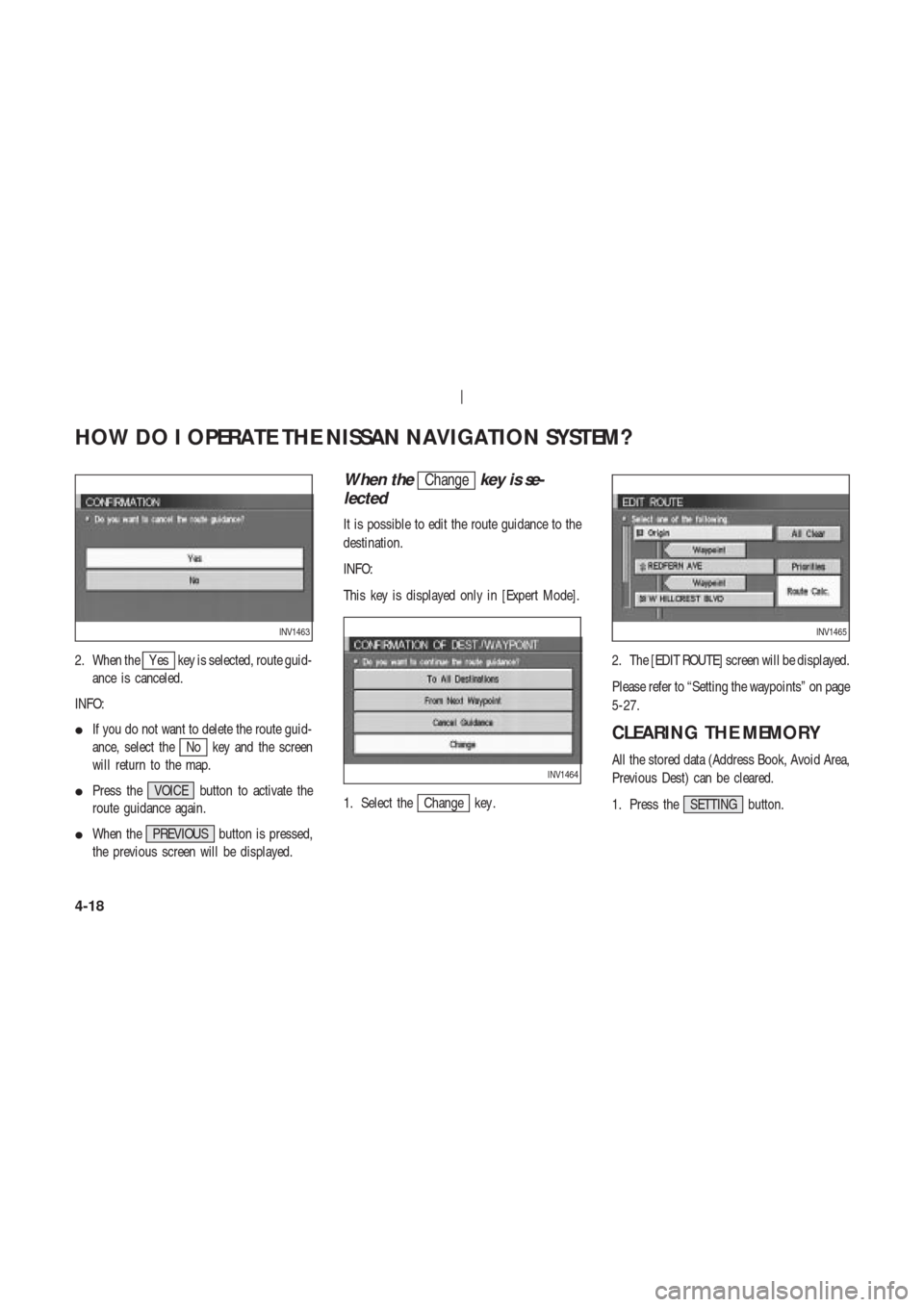
CONFIRMATION OF DESTINA-
TION OR WAYPOINT
When the engine is turned off during route cal-
culation and then turned on, the [CONFIRMA-
TION OF DEST ./WA YPOINT] screen will be
displayed after the [SYSTEM ST ART -UP]
screen.In the [CONFIRMA TION OF DEST ./
WA YPOINT] screen, the following four keys are
displayed.
�T o All Destinations
�From Next Waypoint
�Cancel Guidance
�Change (only in Expert Mode)
INFO:
When the PREVIOUS or MAP button is
pressed in this screen, the [T urn by turn]
INV1458
INV1459
HOW DO I OPERATE THE NISSAN NAVIGATION SYSTEM?
4-16
Page 34 of 174
2. When theY es key is selected, route guid-
ance is canceled.
INFO:
�If you do not want to delete the route guid-
ance, select the
No key and the screen
will return to the map.
�Press the VOICE button to activate the
route guidance again.
�When the PREVIOUS button is pressed,
the previous screen will be displayed.
When theChangekey is se-
lected
It is possible to edit the route guidance to the
destination.
INFO:
This key is displayed only in [Expert Mode].
1. Select the
Change key .2. The [EDIT ROUTE] screen will be displayed.
Please refer to “Setting the waypoints” on page
5-27.
CLEARING THE MEMORY
All the stored data (Address Book, Avoid Area,
Previous Dest) can be cleared.
1. Press the SETTING button.
INV1463
INV1464
INV1465
HOW DO I OPERATE THE NISSAN NAVIGATION SYSTEM?
4-18
Page 35 of 174
2. Select theNavigation key on the
[NAVIGA TION SETTINGS] screen.3. Select the
Clear Memory key .
4. Select the
Y es key .5. When the
Y es key is selected, the stored
data will be cleared, and the [NAVIGA TION
SETTINGS] screen will appear .
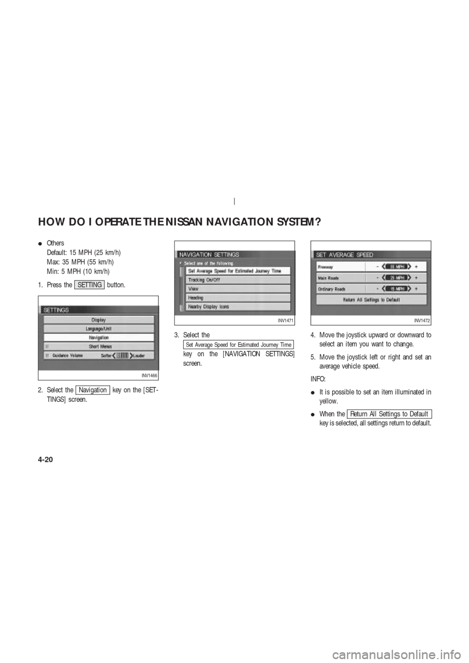
SETTING THE A VERAGE
SPEED
This navigation system can calculate and dis-
play the expected arrival time to the destina-
tion. T o do this, set average vehicle speeds
when driving on freeways, main roads and or-
dinary roads.
The following settings are available.
�Freeway
Default: 55 MPH (90 km/h)
Max: 70 MPH (110 km/h)
Min: 40 MPH (60 km/h)
�Main Roads
Default: 25 MPH (40 km/h)
Max: 50 MPH (80 km/h)
Min: 10 MPH (20 km/h)
INV1466
INV1467
INV1468
INV1469
HOW DO I OPERATE THE NISSAN NAVIGATION SYSTEM?
4-19
Page 36 of 174
�Others
Default: 15 MPH (25 km/h)
Max: 35 MPH (55 km/h)
Min: 5 MPH (10 km/h)
1. Press the SETTING button.
2. Select the
Navigation key on the [SET -
TINGS] screen.3. Select the
Set Average Speed for Estimated Journey Time
key on the [NAVIGA TION SETTINGS]
screen.4. Move the joystick upward or downward to
select an item you want to change.
5. Move the joystick left or right and set an
average vehicle speed.
INFO:
�It is possible to set an item illuminated in
yellow.
�When the
Return All Settings to Default
key is selected, all settings return to default.
INV1466
INV1471INV1472
HOW DO I OPERATE THE NISSAN NAVIGATION SYSTEM?
4-20
Page 38 of 174
 from the destination or waypoint, a
message saying so will appear on the
screen. T r")
route calculation when the vehicle is closer
to the main road.
— If there is no main road within 3.1 miles (5
km) from the destination or waypoint, a
message saying so will appear on the
screen. T ry setting the location closer to the
main road.
— If the vehicle is too close to the destination
or if there are no branches of the roads to
the destination. A message saying so will
appear on the screen.
— If it is deemed impossible to reach the des-
tination or waypoints because of traffic
regulations, etc.
— If the only route to reach the destination or
waypoints is extremely complicated.
— If the destination, current vehicle position
or waypoint is within the avoid area.
— If the setting of avoid areas covers the
routes to the destination, route calculationmay not be possible.
�The following may occur when the route is
being displayed.
— If you are requesting a calculation from the
main road, the origin of the route may not
exactly match the current vehicle position.
— If you are requesting a calculation to the
destination on the main road, the end of the
route may not exactly match the destination.
— If you are requesting a calculation from the
main road, the system may show a route
from another main road. This may be be-
cause the icon to show the current vehicle
position (vehicle icon) is not set accurately .
In that case, park the car in a safe place and
reset the vehicle icon, or continue driving
to see if the vehicle icon appears on the
main road before requesting route calcula-
tion again.
— There are cases in which the system shows
a detoured route to reach the destination orwaypoints, if you set them from memory or
facility information. In order to correct this,
you will have to be careful about the traffic
direction, especially when the lanes with
different travel directions are shown sepa-
rately . Such places are interchanges and
service areas.
— This system makes no distinction between
limited traffic control and total control
(blockage). It may show a detoured route
even if the road is usable.
— Even if the freeway preference is set to OFF ,
the route may be set on them. T o avoid this,
set a waypoint on another road type and re-
quest calculation.
— Even if the preference is set to OFF for a
ferry line, the route may be set on it. T o
avoid this, set a waypoint on a road and re-
quest calculation.
— Ferry lines, except those which accept only
pedestrians, bicycles and motorcycles, are
HOW DO I OPERATE THE NISSAN NAVIGATION SYSTEM?
4-22
![NISSAN 350Z 2003 Z33 Navigation Manual 2. Select theNavigation key on the
[NAVIGA TION SETTINGS] screen.3. Select the
Clear Memory key .
4. Select the
Y es key .5. When the
Y es key is selected, the stored
data will be cleared, and the [NA](/manual-img/5/658/w960_658-34.png "NISSAN 350Z 2003 Z33 Navigation Manual 2. Select theNavigation key on the
[NAVIGA TION SETTINGS] screen.3. Select the
Clear Memory key .
4. Select the
Y es key .5. When the
Y es key is selected, the stored
data will be cleared, and the [NA")