Page 25 of 32
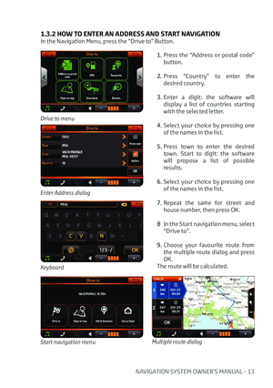
24 - NAVIGATION SYSTEM OWNER’S MANUAL
2.2.4 Other Drive to options
Enter coordinates page
COORDINATES
To set a destination with
lat-lon coordinates:
1. In the Drive to menu press
the “Coordinates” button.
2. Tap on each field to edit it, entering values on the
virtual keyboard.
3. Press OK.
RECENTS
To find a recent
destination:
1. In the Drive to menu press
the “Recents” button.
2. Scroll the list with the arrows and tap the desired
item.
Recents list
POINT ON MAP
This function allows to
explore the map and pick a
point to set as destination.
To pick a point and set
destination:
1. In the Drive to menu press
the “Point on map” button.
2. Explore the map dragging it with a finger.
3. Tap on the desired point to
place the cursor.
4. Press the “Drive to” button on the left side of the map.
Map: picking a destination
Drive to button
DRIVE BACK
This function allows to
calculate the route to the last
starting point. Just press on
it to start the calculation.
Page 26 of 32
NAVIGATION SYSTEM OWNER’S MANUAL - 25
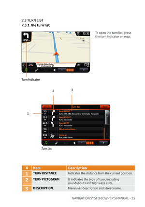
2.3 TURN LIST
2.3.1 The turn list
Turn List
To open the turn list, press
the turn indicator on map.
Turn indicator
12
3
N
Item Description
1TURN DISTANCE Indicates the distance from the current position.
2TURN PICTOGRAMIt indicates the type of turn, including
roundabouts and highways exits.
3DESCRIPTIONManeuver description and street name.
Page 27 of 32
26 - NAVIGATION SYSTEM OWNER’S MANUAL
Turn List pop up menu
2.3.2 How to avoid a manouveur
To avoid a manouveur :
1. In the list, tap on the manouveur.
2. In the pop up menu, press the “Avoid” button.
Once a maneuver is avoided, a route recalculation occurs. Any following route
recalculation will take into account the previously avoided maneuver.
Only in case the route is deleted or a new destination is set, the previously avoided
maneuver will be taken again into account for route creation.
Avoid
Page 28 of 32
NAVIGATION SYSTEM OWNER’S MANUAL - 27
2.4 TRIP OVERVIEW
12
43
5 6 7
N
Item Additional info
1DEPARTURE The icon represents the departure
point.
2CURRENT POSITION DATAThe box displays the distance and the
time to go data.
3ARRIVALThe icon represents the destination
point.
4ARRIVAL DATAThe box displays the total distance
and the total time data.
5DEPARTURE TIMEThe data box displays the time at the
departure point.
6DISTANCE FROM DEPARTUREThe data box displays the distance
covered from the departure.
7ESTIMATED TIME OF ARRIVALThe data box displays the time of
arrival. The estimation is based on
speed limits data.
On the map, tap a point to activate the screen and then press the “Trip overview”
button. This page is available also from the Navigation menu.
Page 29 of 32
28 - NAVIGATION SYSTEM OWNER’S MANUAL
2.5 GPS PAGE
123
4
5
N Item Additional info
1COMPASS Available only with fix position.
2DIRECTIONAvailable only with fix position.
3SKYThe representation of the sky is
north up oriented, as the compass.
4SATELLITE ICONSYellow: low signal.
Green: strong signal.
5SATELLITE SIGNAL LEVELSYellow: low signal.
Green: strong signal.
On the map, tap a point to activate the screen and then tap the GPS status box.
The GPS page is available also from Trip overview page and Full info page.
Page 30 of 32
NAVIGATION SYSTEM OWNER’S MANUAL - 29
Page 31 of 32
Български С��настоящето ���$�Y�0�D�S�� �6���U���O�� �� декларира����че ��този ���; ���1�$�9�� отговаря ��на ��
основните ��изисквания ��и�� други ��съответни ��постановления ��на ��
Директива�����������������(�&�� ��
��
Čeština
AvMap S.r.l tímto prohlašuje, že tento X ���1�$�9 ��je ve shodě se
�]�
Page 32 of 32
www.toyota-europe.comPrinted in UK
PZ49X-90334-CS
PZ49X-90334-DA
PZ49X-90334-DE
PZ49X-90334-EL
PZ49X-90334-ES
PZ49X-90334-FI
PZ49X-90334-FR
PZ49X-90334-HU
PZ49X-90334-IT
PZ49X-90334-NL
PZ49X-90334-NO
PZ49X-90334-PL
PZ49X-90334-PT
PZ49X-90334-RO
PZ49X-90334-RU
PZ49X-90334-SK
PZ49X-90334-SV
PZ49X-90334-TR
PZ49X-90334-UK
Owner‘s manual
AYGO X-NAV
Publication no. AOM 001 592-3PZ49X-90335-EN


 24 - NAVIGATION SYSTEM OWNER’S MANUAL
2.2.4 Other Drive to options
Enter coordinates page
COORDINATES
To set a destination with
lat-lon coordinates:
1. In the Drive to menu press
the “Coordinate")
 NAVIGATION SYSTEM OWNER’S MANUAL - 25
2.3 TURN LIST
2.3.1 The turn list
Turn List
To open the turn list, press
the turn indicator on map.
Turn indicator
12
3
N
Item Description
1TURN DISTANCE Indic")
 26 - NAVIGATION SYSTEM OWNER’S MANUAL
Turn List pop up menu
2.3.2 How to avoid a manouveur
To avoid a manouveur :
1. In the list, tap on the manouveur.
2. In the pop up menu, press the “Avoid”")
 NAVIGATION SYSTEM OWNER’S MANUAL - 27
2.4 TRIP OVERVIEW
12
43
5 6 7
N
Item Additional info
1DEPARTURE The icon represents the departure
point.
2CURRENT POSITION DATAThe box displays the distance an")
 28 - NAVIGATION SYSTEM OWNER’S MANUAL
2.5 GPS PAGE
123
4
5
N Item Additional info
1COMPASS Available only with fix position.
2DIRECTIONAvailable only with fix position.
3SKYThe representation of the")
 NAVIGATION SYSTEM OWNER’S MANUAL - 29")

 www.toyota-europe.comPrinted in UK
PZ49X-90334-CS
PZ49X-90334-DA
PZ49X-90334-DE
PZ49X-90334-EL
PZ49X-90334-ES
PZ49X-90334-FI
PZ49X-90334-FR
PZ49X-90334-HU
PZ49X-90334-IT
PZ49X-90334-NL
PZ49X-90334-NO")