2018 TOYOTA COROLLA iM Accessories, Audio & Navigation (in English)
-
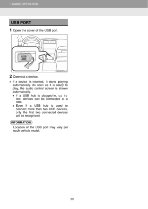
 1
1 -
 2
2 -
 3
3 -
 4
4 -
 5
5 -
 6
6 -
 7
7 -
 8
8 -
 9
9 -
 10
10 -
 11
11 -
 12
12 -
 13
13 -
 14
14 -
 15
15 -
 16
16 -
 17
17 -
 18
18 -
 19
19 -
 20
20 -
 21
21 -
 22
22 -
 23
23 -
 24
24 -
 25
25 -
 26
26 -
 27
27 -
 28
28 -
 29
29 -
 30
30 -
 31
31 -
 32
32 -
 33
33 -
 34
34 -
 35
35 -
 36
36 -
 37
37 -
 38
38 -
 39
39 -
 40
40 -
 41
41 -
 42
42 -
 43
43 -
 44
44 -
 45
45 -
 46
46 -
 47
47 -
 48
48 -
 49
49 -
 50
50 -
 51
51 -
 52
52 -
 53
53 -
 54
54 -
 55
55 -
 56
56 -
 57
57 -
 58
58 -
 59
59 -
 60
60 -
 61
61 -
 62
62 -
 63
63 -
 64
64 -
 65
65 -
 66
66 -
 67
67 -
 68
68 -
 69
69 -
 70
70 -
 71
71 -
 72
72 -
 73
73 -
 74
74 -
 75
75 -
 76
76 -
 77
77 -
 78
78 -
 79
79 -
 80
80 -
 81
81 -
 82
82 -
 83
83 -
 84
84 -
 85
85 -
 86
86 -
 87
87 -
 88
88 -
 89
89 -
 90
90 -
 91
91 -
 92
92 -
 93
93 -
 94
94 -
 95
95 -
 96
96 -
 97
97 -
 98
98 -
 99
99 -
 100
100 -
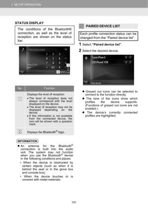 101
101 -
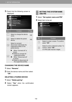 102
102 -
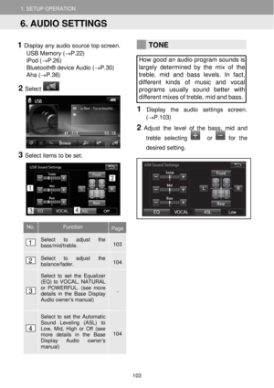 103
103 -
 104
104 -
 105
105 -
 106
106 -
 107
107 -
 108
108 -
 109
109 -
 110
110 -
 111
111 -
 112
112 -
 113
113 -
 114
114 -
 115
115 -
 116
116 -
 117
117 -
 118
118 -
 119
119 -
 120
120 -
 121
121 -
 122
122 -
 123
123 -
 124
124 -
 125
125 -
 126
126 -
 127
127 -
 128
128 -
 129
129 -
 130
130 -
 131
131 -
 132
132 -
 133
133 -
 134
134 -
 135
135 -
 136
136 -
 137
137 -
 138
138 -
 139
139 -
 140
140 -
 141
141 -
 142
142 -
 143
143 -
 144
144 -
 145
145 -
 146
146 -
 147
147 -
 148
148 -
 149
149 -
 150
150 -
 151
151 -
 152
152 -
 153
153 -
 154
154 -
 155
155 -
 156
156 -
 157
157 -
 158
158 -
 159
159 -
 160
160 -
 161
161 -
 162
162 -
 163
163
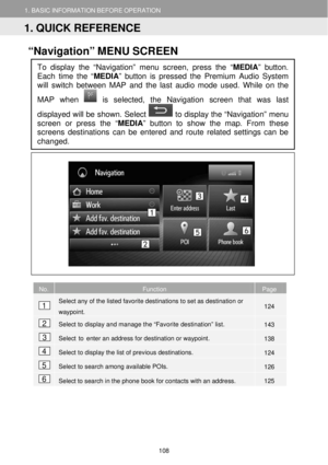
 1. BASIC INFORMATION BEFORE OPERATION 1. BASIC INFORMATION BEFORE OPERATION
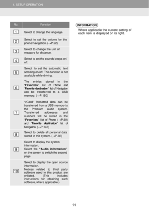
No. Functi on
Quick alpha-jump navigation
through the list based on first letter of the entry name.
Indicator if")
 1. BASIC INFORMATION BEFORE OPERATION
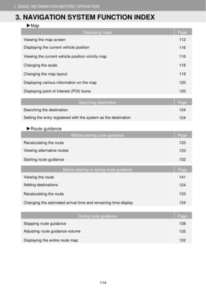
3. NAVIGATION SYSTEM FUNCTION INDEX
1. BASIC INFORMATION BEFORE OPERATION
Map
Displaying maps Page
Viewing the map screen 112
Displaying the curren")
 1. BASIC INFORMATION BEFORE OPERATION
3. NAVIGATION SYSTEM FUNCTION INDEX
1. BASIC INFORMATION BEFORE OPERATION
Memory point
Memory point Page
Registering the entry 143
Editing the en")
 2.MAPSCREENOPERATIONANDMAPICONS
1.MAPSCREENOPERATION
2.MAPSCREENOPERATIONANDMAP
CURRE NT VEHICLE
P OSITION DISPLAY
When starting the navigation system,
the curre nt position isdisplayed first.
This")
 2.MAPSCREENOPERATIONANDMAPICONS
1.MAPSCREENOPERATION
2.MAPSCREENOPERATIONANDMAP
No.Information
Either the destination isshown or access to the destination and
waypointlist.
Current vehicle position in")
 2. MAP SCREEN OPERATION AND MAP ICONS
1. MAP SCREEN OPERATION
2. MAP SCREEN OPERATION AND MAP
SCREEN SCROLL
OPERATION
Wh en any point on the map is
selected, that point moves t")
 2. MAP SCREEN OPERATION AND MAP ICONS 2. MAP SCREEN OPERATION AND MAP ICONS
NAVI
GATION
SYSTEM
CHANGING MAP LAYOUT
1 Select the map la yout icon from the
sideb ar.")
 2.MAPSCREENOPERATIONANDMAPICONS2.MAPSCREENOPERATIONANDMAPICONS
DISPLAYING VARIOUS
INFORM ATION ON THEMAP
Various information canbedisplayed
on the map.
SPEED L IMITS
The speed limitof the road curre")