2018 MERCEDES-BENZ AMG GT R-ROADSTER display
[x] Cancel search: displayPage 221 of 473
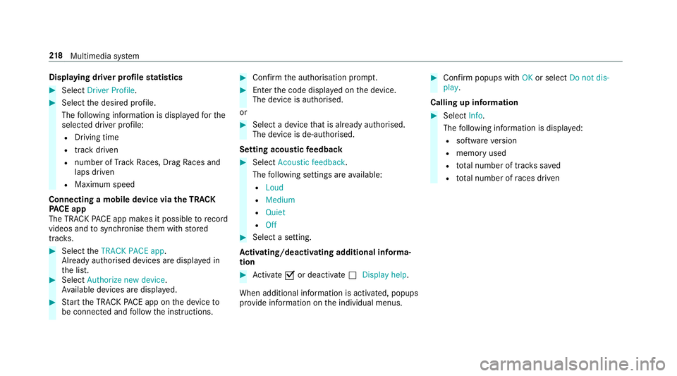
Displaying driver profile
statistics #
Select Driver Profile. #
Select the desired profile.
The following information is displa yedfo rthe
selected driver profile:
R Driving time
R track driven
R number of Track Races, Drag Races and
laps driven
R Maximum speed
Connecting a mobile device via the TRA CK
PA CE app
The TRA CKPACE app makes it possible torecord
videos and tosynchronise them with stored
trac ks. #
Select theTRACK PACE app.
Already authorised devices are displa yed in
th e list. #
Select Authorize new device.
Av ailable devices are displa yed. #
Start the TRA CKPACE app on the device to
be connec ted and follow the instructions. #
Confirm the authorisation prom pt. #
Enter the code displa yed on the device.
The device is authorised.
or #
Select a device that is already authorised.
The device is de-authorised.
Setting acou stic feedba ck #
Select Acoustic feedback.
The following settings are available:
R Loud
R Medium
R Quiet
R Off #
Select a setting.
Ac tivating/deactivating additional in form a‐
tion #
Activate Oor deacti vate ª Display help.
When additional information is acti vated, popups
pr ov ide information on the individual menus. #
Confirm popups with OKor select Do not dis-
play.
Calling up information #
Select Info.
The following information is displa yed:
R software version
R memo ryused
R total number of trac kssaved
R total number of races driven 218
Multimedia sy stem
Page 230 of 473
%
Traf fic re ports are not available in all coun‐
tries.
Showing POIs in the vicinity of the map #
Select Surrounding POIs . #
Swipe left or right on theto uchpad.
or #
Slide the controller tothe left or right.
The pr evious or next POI is highligh ted on the
map. The name or the address is shown. #
Tofilter the display byPOI categor y:
swipe down on theTo uch Control or the
to uchpad.
or #
Slide the controller down. #
Select the POI categor y.
% User defined allowspersonal POI symbols to
be selected (/ page240). Ro
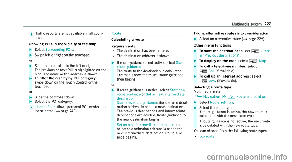
ute Calculating a
route
Re quirements:
R The destination has been entered.
R The destination address is shown. #
Ifro ute guidance is not active, select Start
route guidance .
The route tothe destination is calculated.
The map sho ws thero ute. Route guidance
th en begins.
or #
Ifro ute guidance is active, select Start new
route guidance orSet as next intermediate
destination .
Start new route guidance: the selected desti‐
nation address is set as a new destination.
The pr evious destinations and intermediate
destinations are dele ted. Ro ute guidance to
th e new destination begins.
Set as next intermediate destination :the
selected destination address is set as the
next intermedia tedestination. Route guid‐
ance begins. Ta
king alternative routes into conside ration #
Select an al tern ative route (/ page 229).
Other menu functions #
Tosave the destination: select¥Store
in "Previous destinations". #
Todispl ayon the map: select¥Map. #
Tocall a telephone number: select
¥ Call(ifavailable). #
Tocall up an Internet address: select
¥ www(ifavailable).
Selecting a route type
Multimedia sy stem:
4 Navigation 5
À Route and position #
Select Route settings. #
Select thero ute type.
If ro ute guidance is active, the new route is
calculated with the new route type.
If ro ute guidance is not active, the next route
is calculated with the new route type.
Yo u can choose from thefo llowing route types:
R Eco route Multimedia sy
stem 227
Page 234 of 473
Driving instructions may di
ffer from the actual
ro ad and traf fic conditions if:
R The route is diver ted
R The direction of a one-w aystre et has been
ch anged
Fo rth is reason, you must alw ays obser veroad
and traf fic ru les and regulations during your
journey as well as the pr evailing traf fic condi‐
tions.
The route may dif fer from the ideal route due to
th efo llowing:
R Roadwor ks
R Incomple tedigital map data
Note s on GPS reception
The cor rect function of the navigation sy stem
depends amongst other things on GPS recep‐
tion. In cer tain situations GPS reception can be
impaired, defective or even not possible, e.g. in
tunnels or in multi-s torey car par ks. Changing direction
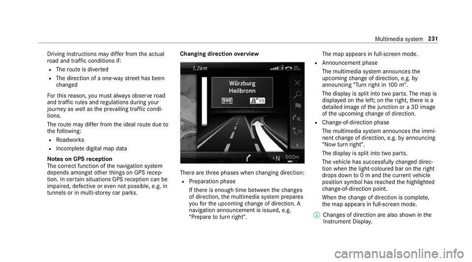
overview There are
thre e phases when changing direction:
R Preparation phase
Ifth ere is enough time between thech anges
of direction, the multimedia sy stem prepares
yo ufo rth e upcoming change of direction. A
navigation announcement is issued, e.g.
"Prepare toturn right". The map appears in full-screen mode.
R Announcement phase
The multimedia sy stem announces the
upcoming change of direction, e.g. by
announcing "Turn right in 100 m".
The display is split into two parts. The map is
displa yed on the lef t;on theright, there is a
de tailed image of the junction or a 3D image
of the upcoming change of direction.
R Chan ge-of-direction phase
The multimedia sy stem announces the immi‐
nent change of direction, e.g. byannouncing
"N ow turn right".
The display is split into two parts.
The vehicle has successfully changed direc‐
tion when the light-coloured bar on theright
drops down to0 m and the cur rent vehicle
position symbol has reached the highlighted
ch ange-of-direction point.
When thech ange of direction is comple te,
th e map appears in full-screen mode.
% Changes of direction are also shown in the
Instrument Displa y. Multimedia sy
stem 231
Page 235 of 473
Lane
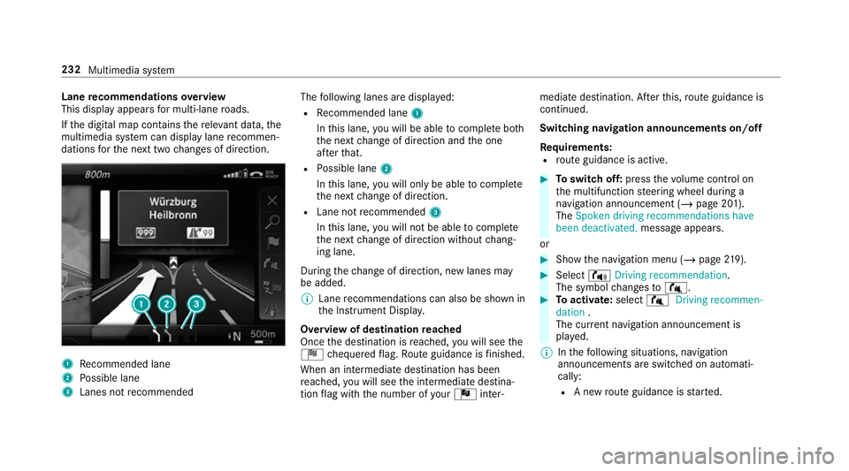
recommendations overview
This display appears for multi-lane roads.
If th e digital map conta insthere leva nt da ta,the
multimedia sy stem can display lane recommen‐
dations forth e next two changes of direction. 1
Recommended lane
2 Possible lane
3 Lanes not recommended The
following lanes are displa yed:
R Recommended lane 1
In this lane, you will be able tocompl ete bo th
th e next change of direction and the one
af te rth at.
R Possible lane 2
In this lane, you will on lybe able tocompl ete
th e next change of direction.
R Lane not recommended 3
In this lane, you will not be able tocompl ete
th e next change of direction without chang‐
ing lane.
During thech ange of direction, new lanes may
be added.
% Lane recommendations can also be shown in
th e Instrument Displa y.
Overview of destination reached
Once the destination is reached, you will see the
Í chequered flag. Route guidance is finished.
When an intermedia tedestination has been
re ached, you will see the intermediate destina‐
tion flag with the number of your Î inter‐ mediate destination. Af
terth is, route guidance is
continued.
Swit ching navigation announcements on/off
Re quirements:
R route guidance is active. #
Toswitch off: pressthevo lume control on
th e multifunction steering wheel during a
navigation announcement (/ page 201).
The Spoken driving recommendations have
been deactivated. message appears.
or #
Show the navigation menu (/ page219). #
Select !Driving recommendation .
The symbol changes to# . #
Toactivate: select#Driving recommen-
dation .
The cur rent navigation announcement is
pl ay ed.
% Inthefo llowing situations, navigation
announcements are switched on automati‐
cally:
R A new route guidance is star ted. 232
Multimedia sy stem
Page 241 of 473
-
slow-moving traf fic (orange line)
- heavy traf fic (yellow line)
- free-flowing traf fic (green line)
R displ ayfor traf fic del ays on thero ute lasting
at least one minute
R warning message symbols:
- d symbol
- additional road saf ety no tes when
approaching a traf fic incident, e.g. the
end of a tra ffic jam
If th eve hicle approaches a danger area
on thero ute, a warning message is dis‐
pla yed on the map. A warning message
may also be issued (/ page 238).
Displaying traf fic incidents
Multimedia sy stem:
4 Navigation 5
Z Options
5 Map content #
Activate OTraffic incidents.
Ro adwor ks,ro ad bloc ks, local area reports
(e.g. fog) and warning messages are dis‐
pla yed. Ac
tivating free flow and traffic display #
Activate OFree-flowing traffic andTraffic
delays.
% The traf fic del ayis displa yedfo rth e cur rent
ro ute. Traf fic del ays lasting one minute or
longer are take n into conside ration.
Displ aying details #
Displaying the tra ffic map (/ page 237). #
Moving the map (/ page240). #
When a traffic re port symbol is under the
crosshair, press on the cent ral control ele‐
ment.
The traf fic re port de tails are displa yed.
or #
Press on the cent ral control element. #
Select Information on traffic reports .
The map sho ws the traf fic re port symbols in
th e vicinit y.
Tr af fic re port information is displa yed in the
st atus line:
R Traf fic re port symbol R
Reason forth e tra ffic report, e.g. tra ffic
con gestion
R Warning message (highligh ted in red) #
Toselect a traf fic re port symbol: select
Next orPrevious. #
Press on the cent ral control element.
The traf fic re port de tails are displa yed.
Issuing hazard warnings
Multimedia sy stem:
4 Navigation 5
Z Options
5 Announcements #
Activate OAnnounce traffic warnings .
Wa rning messages are issued and tailbac ks
which pose a risk are announced. 238
Multimedia sy stem
Page 242 of 473
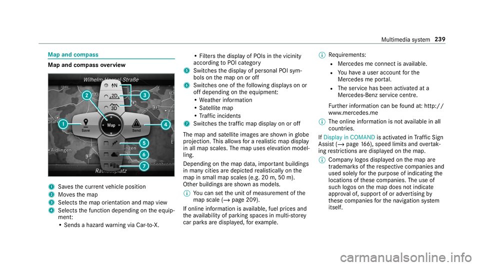
Map and compass
Map and compass
overview 1
Savesth e cur rent vehicle position
2 Movesth e map
3 Selects the map orientation and map view
4 Selects the function depending on the equip‐
ment:
• Sends a hazard warning via Car-to-X. • Filters
the display of POIs in the vicinity
according toPOI category
5 Switches the display of personal POI sym‐
bols on the map on or off
6 Switches one of thefo llowing displa yson or
off depending on the equipment:
• We ather information
• Satellite map
• Traf fic incidents
7 Switches the tra ffic map display on or off
The map and satellite images are shown in globe
projection. This allo wsfor a realistic map display
in all map scales. The map uses ele vation model‐
ling.
Depending on the map data, impor tant buildings
in ma nycities are depicted realistically on the
map in small map scales (e.g. 20 m, 50 m).
Other buildings are shown as models.
% You can set the unit of measurement of the
map scale (/ page 209).
If online information is available, fuel prices and
th eav ailability of parking spaces in multi-s torey
car pa rks are displa yed, forex ample. %
Requirements:
R Mercedes me connect is available.
R You ha vea user account forthe
Mercedes me por tal.
R The service has been activated at a
Mercedes-Benz service centre.
Fu rther information can be found at: http://
www.mercedes.me
% The online information is not available in all
countries.
If Display in COMAND is activated inTraf fic Sign
Assi st (/ page 166), speed limits and overtak‐
ing restrictions are displ ayed on the map.
% Company logos displa yed on the map are
trademar ksofthere spective companies and
used solely forth e purpose of indicating the
locations of these companies. The use of
such logos on the map does not indicate
appr oval of, suppo rtof or advertising by
th ese companies forth e navigation sy stem
itself. Multimedia sy
stem 239
Page 243 of 473
Setting
the map scale
Re quirements:
R The map is shown.
Multimedia sy stem:
4 Navigation
% You can set the unit of measurement of the
map scale (/ page 209).
Moving the map
Multimedia sy stem:
4 Navigation 5
Z Options
5 Map menu #
Alternatively, if the map is displa yed in full
screen mode, press the cent ral control ele‐
ment.
The map menu appears. #
Select "Mo vemap" in map menu 2
(/ page 239). Selecting
the map orientation
Multimedia sy stem:
4 Navigation 5
Z Options
5 Map menu #
Alternatively, if the map is displa yed in full
screen mode, press the cent ral control ele‐
ment.
The map menu appears. #
In map menu 3, select N,2D or
3D( /page 239).
R N:the 2D map view is displa yed so that
no rth is alw ays at theto p.
R 2D: the 2D map view is aligned tothe
direction of tr avel.
R 3D: the 3D map view is aligned tothe
direction of tr avel.
Selecting POI symbols
Multimedia sy stem:
4 Navigation 5
Z Options
5 Map content #
Select POI symbols .
The #dot indicates the cur rent setting. Standard
displays symbols of predefined cat‐
egories on the map.
User defined allowsyouto personally select
th e symbols forth eav ailable categories.
None switches the display off. #
Select a setting. #
User defined : select categories.
The POI symbols of the selected categories
are displa yedO or not displa yedª.
Selecting the display of text information in
th e map
Multimedia sy stem:
4 Navigation 5
Z Options
5 Text information #
Select text information.
Current street showsthest re et you are cur‐
re ntly driving on at the bottom of the displa y.
When the map is mo ved, thefo llowing infor‐
mation appears under the crosshair:
R stre et name
R POI name
R area name 240
Multimedia sy stem
Page 244 of 473
Geo-coordinates
displays thefo llowing infor‐
mation:
R longitude and latitude
R elevation
The el evation shown may deviate from
th e actual ele vation.
R number of sa tellites from which a signal
can be recei ved
When the map is mo ved, this information
does not appear.
Climate control displays the cur rent clima te
control settings.
None switches the display off.
Displaying the next intersecting stre et
Re quirements:
R Route guidance is not active.
Multimedia sy stem:
4 Navigation 5
Z Options #
Activate ONext intersecting street .
The name of the next intersecting stre et will
be displa yed at the upper edge of the displa y.Displaying
the map version
Multimedia sy stem:
4 Navigation 5
Z Options #
Select Map version . #
Select Details.
% Information about new versions of the digital
map can be obtained from a Mercedes-Benz
service cent re.
Overview of avoiding an area
Yo u can define areas along a route that you
wo uld like toavoid.
The route can include an area that is tobe avoi‐
ded in thefo llowing situations:
R the destination is located in an area that is to
be avo ided
R if mo torw ays are located within the area that
is to be avoided
Mo torw ays are alw aysta ke n into account for
th ero ute.
R there is no sensible alternative route Av
oiding a new area
Multimedia sy stem:
4 Navigation 5
À Route and position
5 Avoid options 5
Areas #
Select Avoid new area. #
Tosear chfor an area via the map: select
Using map. #
Movethe map
or #
Tosear chfor an area using an address:
select Address entry . #
Enter the address. #
Select Select destination.
The map appears.
Changing an area
Multimedia sy stem:
4 Navigation 5
À Route and position
5 Avoid options 5
Areas #
Highlight an area in the list. #
Select ¥Edit. Multimedia sy
stem 241