Page 73 of 90
 73
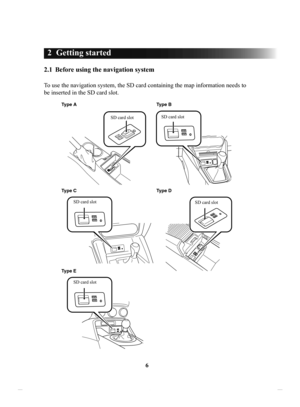
1
2
3
4
5
6
4 Reference Guide
4.1 Concepts
4.1.1 Smart Zoom
Smart Zoom provides much more than just a usual automatic zoom feature:
• While following a route: when approaching a turn, it wi")
73
1
2
3
4
5
6
4 Reference Guide
4.1 Concepts
4.1.1 Smart Zoom
Smart Zoom provides much more than just a usual automatic zoom feature:
• While following a route: when approaching a turn, it will zoom in and raise the
view angle to let you easily recognize your maneuver at the next junction. If the
next turn is at a distance, it will zoom out and lower the view angle to be flat so
you can see the road in front of you.
• While driving without an active route: Smart Zoom will zoom in if you drive
slowly and zoom out when you drive at high speed.
• Off: Turns the Smart Zoom setting off.
4.1.2 Route calculation and recalculation
The navigation system calculates the route based on your preferences:
• Route planning methods:
• : Gives a quick route if you can travel at or near the speed limit
on all roads.
• : Gives a route that has the smallest total distance of all possible
routes.
• : This method combines the merits of the Fast and Short
routes: The navigation system makes a calculation for the Fast route,
but it also includes other roads in the calculation in consideration of fuel
economy.
• : Results in a route with fewer turns and no difficult maneuvers.
With this option, you can make the navigation system take, for example,
the highway/freeway instead of a series of smaller roads or streets.
• Road type used for route plan: •
•
•
•
•
•
•
Whenever data exist, route calculation takes into account historical traffic data for
the given day of week and time of day (page 76).
If the setting for Traffic Settings is valid, Real-time Traffic events are taken into
account and the route is largely modified.
The navigation system automatically recalculates the route if you deviate from
the proposed itinerary or if a newly received Traffic event concerns a part of the
recommended route.
For further information about Route Settings see page 80.
Some functions are not available depending on some countries and regions.
NAV-12AVUAE.indb 732015/02/20 15:09:15
Page 74 of 90
 74
4.1.3 Road
safety cameras and other proximity alert points (Only some
countries and regions)
There is a special proximity warning for road safety cameras (like speed or red light
cameras) and o")
74
4.1.3 Road
safety cameras and other proximity alert points (Only some
countries and regions)
There is a special proximity warning for road safety cameras (like speed or red light
cameras) and other proximity alert points (like schools or railroad crossings).
The application can warn you when you approach road safety cameras like speed
cameras or dangerous areas like school zones or railroad crossings. Y
ou can set up
the different alert types individually in Warning Settings (page 78).
The following alert types are available:
•
Audio warning: When approaching one of these points, a beep sound (regular
sound) can be used or the type of warning can be announced (TTS), and an extra
alert can warn you if you exceed the given speed limit while approaching the
point.
•
Always: The type of the alert point, its distance, and the related speed limit appear
on the Map screen while you are approaching one of these points.
For some of the alert points, the enforced or expected speed limit is available. For
these points, the audio alert can be different if you are below or above the given
speed limit.
Setting can be selected using
Warning Settings:
•
Only when speeding: The audio alert is only played when you exceed the given
speed limit.
•
When approaching: The audio alert is always played when approaching one of
these alert points. T
o draw you attention, the alert may differ if you exceed the
speed limit.
The warning for road safety cameras is disabled when you are in a country where
road safety camera warning is prohibited. However, you must ensure on your own
liability that using this feature is legal in the country where you intend to use it.
NAV-12AVUAE.indb 742015/02/20 15:09:15
Page 75 of 90
 75
1
2
3
4
5
6
4.1.4 Speed limit warning (Only some countries and regions)
Maps may contain information about the speed limits of the roads. The navigation
system is able to warn you if you exceed")
75
1
2
3
4
5
6
4.1.4 Speed limit warning (Only some countries and regions)
Maps may contain information about the speed limits of the roads. The navigation
system is able to warn you if you exceed the current limit. This information may not
be available for your region (ask your local dealer), or may not be fully correct for
all roads on the map.
The speed warning can be set from the W
arning Settings (page 78).
Setting can be selected using Warning Settings:
•
Audio warning: You will hear a warning beep if you exceed the speed limit by a
certain percentage.
•
Visual warning: If you exceed the speed limit on a road, the speed limit for the
current road is shown on the map.
You can also choose to see the speed limit sign on the map all the time.
4.1.5
Traffic information in route planning (Only some countries and regions)
The recommended route is not always the same between two points. Offline
historical traffic information (historical speed information or traffic patterns) can
be taken into account in the route calculation based on the time of day and the day
of week whenever suitable data exists. In addition, real-time traffic information can
help you avoid current traffic events like temporary road closures or a traffic jam
caused by an accident. Both functions are subject to data availability .
Select
after selecting on the MAP screen to display the historical traffic
information on the map. A 2D map is displayed with road segments colored by the
density of the traffic in the given period. The current information is shown when
you open the screen. Modify the day of week and the time of day to see the desired
period.
NAV-12AVUAE.indb 752015/02/20 15:09:15
Page 76 of 90
76
4.1.5.1 Historical
traffic
If historical traffic information is available with the map data, the navigation system
can use it when planning a route. In normal cases, these statistics help you avoid
usual traffic jams on the given day of week in the given hour but in some cases like
on public holidays that fall on normal weekdays, they can be misleading. You can
disable this feature in
Traffic Settings (page 79).
Select
after selecting on the MAP screen to display the historical traffic
information on the map.
NAV-12AVUAE.indb 762015/02/20 15:09:15
Page 77 of 90
77
1
2
3
4
5
6
4.2 Settings menu
You can configure the program settings, and modify the behaviour of the navigation
system. Select
after selecting on the MAP screen.
ButtonDescription
You can fine-tune the appearance of the Map screen. Adjust
the map view to your needs, show or hide 3D buildings, and
manage POI (point of interest) display settings (which POI
to show on map).
A guidance-related setting is available during route
guidance.
A setting related to warnings is available.
Refer to Changing the road types used in route planning
(page 68).
A setting for traffic information is available.
A setting for on-line service is available.
Some functions are not available depending on some countries and regions.
NAV-12AVUAE.indb 772015/02/20 15:09:15
Page 78 of 90
 78
4.2.1 Guidance
Settings
Button
Description
The guidance audio volume can be changed during
route guidance.
4.2.2 Warning
Settings
Warning and alert settings are available.
Button Description")
78
4.2.1 Guidance
Settings
Button
Description
The guidance audio volume can be changed during
route guidance.
4.2.2 Warning
Settings
Warning and alert settings are available.
Button Description
The following alert types are available:
: No display and sound
: Only display
: Both sound and display
*
If the guidance volume is set to 0, the speed limit
notification is also 0 because it is part of the guidance.
The speed limit warning display can be changed.
Always : Constantly displayed
When speeding : Displays only when vehicle speed
exceeds speed limit
A setting is available which sounds a beep at alert points,
and it can be set to on or off. In addition, detailed settings
concerning the warning can be made.
: No display and sound
: Only display
: Both sound and display
The speed camera warning setting can be changed.
: No display and sound
: Only display
: Both sound and display
Some functions are not available depending on some countries and regions.
NAV-12AVUAE.indb 782015/02/20 15:44:10
Page 79 of 90
79
1
2
3
4
5
6
4.2.3 Traffic Settings
ButtonDescription
Use this switch to enable or disable historical
traffic data and traffic patterns. This locally
stored information can be very useful in normal
circumstances but for example on public
holidays it may be better to turn off in order
not to take into account normal weekday traffic
jams.
Alternative routes are offered for detours.
An appropriate alternative route is determined
provided by the navigation system in
consideration of traffic conditions.
You can select how much time delay on the
alternative route you are willing to accept.
The alternative route is offered based on the set
time.
Some functions are not available depending on some countries and regions.
NAV-12AVUAE.indb 792015/02/20 15:09:15
Page 80 of 90
 80
4.2.4 Route
Settings
These settings determine how routes will be calculated.
Button
Description
The route calculation can be optimized for
different situations. See below for details.
You migh")
80
4.2.4 Route
Settings
These settings determine how routes will be calculated.
Button
Description
The route calculation can be optimized for
different situations. See below for details.
You might need to avoid highways/freeways if
you are towing another vehicle.
Charge roads are pay roads where you can
purchase a pass or vignette to use the road for
a longer period of time. They can be enabled or
disabled separately from toll roads.
The navigation system includes toll roads (pay
roads where there is a per-use charge) in the
routes by default. If you disable toll roads, the
navigation system plans the best toll-free route.
The navigation system includes ferries in a
planned route by default. However, a map does
not necessarily contain information about the
accessibility of temporary ferries. You might
also need to pay a fare on ferries.
Setting in which routes with carpool lanes can
be created or not created.
A border crossing may be a shorter route
depending on the route. For this function, you
can select whether or not to cross a border when
planning the route.
The navigation system excludes unpaved roads
by default: unpaved roads can be in a bad
condition and usually you cannot reach the
speed limit on them.
Some functions are not available depending on some countries and regions.
NAV-12AVUAE.indb 802015/02/20 15:09:16


 76
4.1.5.1 Historical
traffic
If historical traffic information is available with the map data, the navigation system
can use it when planning a route. In normal cases, these statistics help you av")
 77
1
2
3
4
5
6
4.2 Settings menu
You can configure the program settings, and modify the behaviour of the navigation
system. Select
after selecting on the MAP screen.
ButtonDescription
You can fi")
 79
1
2
3
4
5
6
4.2.3 Traffic Settings
ButtonDescription
Use this switch to enable or disable historical
traffic data and traffic patterns. This locally
stored information can be very useful in nor")