Page 225 of 250
 and
require an")
224
Reference Information
System Limitations
GPS System
The signals received from the GPS satellites
are extremely weak (less than a millionth of
the strength of a local FM station) and
require an unobstructed view of the sky.
The GPS antenna is located in the
dashboard. The signal reception can easily
be interrupted or interfered with by the
following:
• Metallic window tint on the front or side wind ows
•
Cell phones, PDAs, or other electronic
de
vices docked in a cradle or lying loose
on the dashboard
• Remote starters or “hidden” vehicle tracking system s
mounted near the
navigation unit
• Audio electronic devices mounted near the nav i
gation unit
• Trees, tall buildings , freeway overpasse
s,
tunnels, or overhead electrical power
wires
The GPS is operated by the U.S. Department
of Def ense. For
security reasons, there are
certain inaccuracies bu ilt into the GPS for
which the navigation system must
constantly compensate. This can cause occasional positioning errors of up to
several hundred feet.
Address Calculation
The destination icon shows only the
approximate location of a destination
address. This occurs if the number of
possible addresses is different from the
number of actual addr
esses on a block. For
example, the address 1425 on a 1400 block
with 100 possible addresses (because it is
followed by the 1500 block) will be shown a
quarter of the way down the block by the
system. If there are only 25 actual addresses
on the block, the actual location of address
1425 would be at the end of the block.
Database
The digitized map database reflects
conditions as they existed at various points
in time before production. Accordingly,
your database may contain inaccurate or
incomplete data or information due to the
passage of time, road construction,
changing conditions, or other causes.
For example, some places/landmarks may
be missing when you
search the database
because the name was misspelled, the place
was improperly categorized, or a place/
landmark is not yet in the database. This is
also true for police st ations, hospitals, and
other public institutions. Do not rely on the
navigation system if you need law
enforcement or hospital services. Always
check with local in formation sources.
Page 226 of 250

225
uu System Limitations u Database
Reference Information
In addition, the map database contains
verified and unverified areas. Unverified
streets may be missing from the map, in the
wrong location, or have an incorrect name
or address range. A message will warn you
if your route includes unverified streets.
Exercise additional caution when driving in
unverified areas.
The database does not include, analyze,
process, consider, or reflect any of the
following categories of information:
• Neighborhood quality or safety
• Population density
• Availability or proximity of law
enforcem ent
•
Emergency, rescue, medical, or other
assistance
• Construction work, zones, or hazards
• Road and lane closures
• Legal restrictions (such as vehicular type, weight, load, height
, and speed
restrictions)
• Road slope or grade
• Bridge height, width, weight, or other
limi
ts
• Traffic facilities safety
• Special events
• Pavement characteristics or conditions Every effort has been made to verify that
the database is acc
u
rate. The number of
inaccuracies you expe rience increases the
longer you go with out obtaining an
updated map database.
2 Obtaining a Navigation Update P. 228
We assume no liability for any incident that
may result from an error in the program, or
from changed conditions not noted above.
Page 227 of 250

226
Reference Information
Customer Assistance
Resolving Problems
If you run into a specific issue that you
cannot resolve, consult the following help
resources:
• For navigation system issues:
2Troubleshooting P. 206
There are also FAQs available online at
automobiles.honda.com .
• For questions regarding Bluetooth®
HandsFreeLink ®:
2Bluetooth ® Hand sFreeLink® P. 168
• For questions regarding the smartphone
connection:
– U.S.: Visit hand
sfreelink.honda.com .
– Canada: Visit www.handsfreelink.ca.
•
For traffic-related issues:
2 Traffic P. 208
• For reporting issues with the database or
places/landmarks:
2 Reporting Errors P. 226
• Call Honda Automobile Customer
Service.
2 Honda Automobile Customer Service
Contact Information P. 226
Reporting Errors
You can help to improve database accuracy
by reporting any er rors you encounter.
• Report errors in freeways and main “veri
fied” roads shown in black on the
map at http://mapreporter.navteq.com/
dur-web-external/ .
• Please do not report errors in purple
“unverified” roa d
s. Maps for these areas
are provided for reference only.
2 Unverified Routing P. 40
• Please do not report errors in places/
landmarks, such as changes in business
names. Information about points of
interest are constantly being updated. An
updated database is available for
purchase, usually in the fall of each year.
2 Obtaining a Navigation Update
P. 228
• For vehicle position icon errors, screen
error messages, or other GPS-related
errors:
2 Troubleshooting P. 206
2 System Limitations P. 224
Honda Automobile
Customer Service Contact
Information
Honda Navi
American Honda Motor Co., Inc.
Honda Automobile Customer Service
Mail Stop 500-2N-7A
1919 Torrance Blvd.
Torrance, CA 90501-2746
Tel: (800) 999-1009
Fax: (310) 783-3023
Honda Canada Inc.
Honda Customer Relations
180 Honda Blvd.
Markham, ON
L6C 0H9
Tel: (888)-9-HONDA-9
Hours: 8:00 am to 7:30 pm Mon to Fri (EST)
Page 228 of 250

227
uu Customer Assistance u Visiting Your Dealer
Reference Information
Visiting Your Dealer
If you have a question that you cannot
resolve using the available help resources,
you can consult your dealer. Please identify
the specific issue (e.g., error occurs when
you enter a specific a ddress, when driving
on a certain road, or just when it’s cold) so
that the service advisor can refer the issue to
the factory so that a so lution can be found.
Be patient, the service advisor may be
unfamiliar with your specific issue.
Map Coverage
The navigation system provides map
coverage for the contiguous United States,
Alaska, Hawaii, Canada, and Puerto Rico.
The map coverage consists of accurately
mapped (verified) metropolitan areas and a
less accurate (unverified) rural database.
Note that unverified areas are constantly
being reviewed and co nverted to verified
areas each year.
Contiguous United States
Hawaii Puerto Rico
Canada
Alaska
Map coverage update information is
available from Honda Automobile
Customer Service or online at:
•U.S.: www.hondanavi.com
• Canada: www.honda.c
a
To find navigation system update
information:
1. Visit the website:
• U.S.: ww
w.hondanavi.com
•
Canada: www.honda.ca
2. Select your vehicle model and model
ye
ar.
3. Click Map Coverage to disp
lay a list of
verified coverage areas on the most
recent update.
4. Click Map Co verage Detai
ls to display a
PDF document with a full listing of all
coverage areas.
u Adobe® Reader®
is required for
viewing and printing the Portable
Document Format (PDF) documents.
To download the latest version of
Adobe Reader, visit http://
get.adobe.com/reader/.
Page 229 of 250

228
uu Customer Assistance u Obtaining a Navigation Update
Reference Information
Obtaining a Navigation
Update
Honda is continually expanding the scope of
the navigation system. Navigation system
software upgrades may be made available
periodically, usually in the fall of each year.
To purchase an updated data file:
1. Ob
tain your vehicle’s VIN number and the
System/Device Infor
mation.
2System/Device Information P. 200
2. Call the Honda Naviga tion Disc Fulfilment
Center at (888) 291-4675, or order
online at:
•U.S.: www.hondan
avi.com
• Canada: www.
honda.ca
Updated data is not available from your
dealer. Howeve
r, the dealer may assist you
in obtaining one out of courtesy. There is no
program for free updates.
Traffic Information
• Continuously updated traffic information is available in certain areas across the
lower 48 U.S. states, Hawaii, and
Canada.
•Visit automobiles.honda.com/traffic for a
complete listing of coverage areas and
other information.
Operation in Alaska,
Hawaii, Canada, and
Puerto Rico
Navigation-equipped vehicles delivered to
Alaska, Hawaii, and Puerto Rico are
equipped with SiriusXM ® hardware, but
SiriusXM ® broadcasting is not available.
There are certain functions that rely on
SiriusXM ® satellite signal coverage which
are not available. Unavailable menu options
will appear gray on the LCD display.
All roads displayed on the map screens are
verified roads. Infor matio
n in this manual
■SiriusXM
® Radio *
■Map Coverage
relating to “unverified”
roads or areas is not
applicable.
Entering a destinati on address or place/
land
mark on another island may result in a
screen caution messag e. This is because
there are no ferry rout es between islands in
the database.
Shipping a Vehicle to the
U.S. Mainland
To receive SiriusXM ® * audio, you must call
SiriusXM ® and set up an account at
(800) 852-9696.
■ Address and Place Entry
Screens
* Not available on all models
Page 230 of 250
 is provided for your
personal, internal use only and not for
resale. It is protected by copyright, and is
s")
229Continued
Reference Information
Legal Information
User Agreement
The data (“Data”) is provided for your
personal, internal use only and not for
resale. It is protected by copyright, and is
subject to the following terms and
conditions which are ag reed to by you, on
the one hand, and NAVTEQ North America,
LLC (“NT”) and its licensors (including their
licensors and suppliers) on the other hand.
© 2012 NAVTEQ. All rights reserved.
This data includes information taken with
permissi on from
Canadian authorities,
including © Her Majesty the Queen in Right
of Canada, © Queen's Printer for Ontario, ©
Canada Post Corporation, GeoBase®, ©
The Department of Natural Resources
Canada. All rights reserved.
NAVTEQ holds a non-exclusive license from
the United S
tates Postal Service® to publish
and sell ZIP+4® information.
©United States Postal Se rvice®
2009. Prices
are not established, controlled or approved
by the United States Postal Service®. The
following trademarks and registrations are
owned by the USPS: United States Postal
Service, USPS, and ZIP+4.
■ END-USER TERMSPersonal Use Only. You agree to use this
Data for the solely personal, non-
commercial purposes for which you were
licensed, and not for service bureau, time-
sharing or other similar purposes.
Accordingly, but subjec
t to the restrictions
set forth in the following paragraphs, you
may copy this Data only as necessary for
your personal use to (i) view it, and (ii) save
it, provided that you do not remove any
copyright notices that appear and do not
modify the Data in any way. You agree not
to otherwise reproduce, copy, modify,
decompile, disassemble or reverse engineer
any portion of this Data, and may not
transfer or distribute it in any form, for any
purpose, except to the extent permitted by
mandatory laws. Multi-disc sets may only be
transferred or sold as a complete set as
provided by NT and not as a subset thereof.
Restrictions. Except where you have been
sp ecifi
cally licensed to do so by NT, and
without limiting the preceding paragraph,
you may not (a) use this Data with any
products, systems, or applications installed
or otherwise connected to or in
■ TERMS AND CONDITIONScommunication with vehicles, capable of
vehicle navigation, positioning, dispatch,
real time route guidance, fleet management
or similar applications; or (b) with or in
communication with any positioning
devices or any mobile or wireless-connected
electronic or computer devices, including
without limitation cellular phones, palmtop
and handheld computers, pagers, and
personal digital assistants or PDAs.
Warning. The Data may contain inaccurate
or incomplete
information due
to the
passage of time, changing circumstances,
sources used and the na ture of collecting
comprehensive geographic data, any of
which may lead to incorrect results.
No Warranty. This Data is provided to you
“as is,” and you agree to use it
at your own
risk. NT and its licensor s (and their licensors
and suppliers) make no guarantees,
representations or warranties of any kind,
express or implied, arising by law or
otherwise, including but not limited to,
content, quality, accuracy, completeness,
effectiveness, reliab ility, fitness for a
particular purpose, usefulness, use or results
to be obtained from this Data, or that the
Page 231 of 250

230
uu Legal Information u User Agreement
Reference Information
Data or server will be uninterrupted or
error-free.
Disclaimer of Warranty: NT AND ITS
LICENSORS (INCLUDING THEIR LICENSORS
AND SUPPLIERS) DISCLAIM ANY
WARRANTIES, EXPRESS OR IMPLIED, OF
QUALITY, PERFORMANCE,
MERCHANTABILITY, FITNESS FOR A
PARTICULAR PURPOSE OR NON-
INFRINGEMENT. Some States, Territories
and Countries do not allow certain warranty
exclusions, so to th at extent the above
exclusion may not apply to you.
Disclaimer of Liability: NT AND ITS
LICEN SORS (INCLU
DING THEIR LICENSORS
AND SUPPLIERS) SHALL NOT BE LIABLE TO
YOU: IN RESPECT OF ANY CLAIM, DEMAND
OR ACTION, IRRESPECTIVE OF THE NATURE
OF THE CAUSE OF THE CLAIM, DEMAND
OR ACTION ALLEGING ANY LOSS, INJURY
OR DAMAGES, DIRECT OR INDIRECT,
WHICH MAY RESULT FROM THE USE OR
POSSESSION OF THE INFORMATION; OR
FOR ANY LOSS OF PROFIT, REVENUE,
CONTRACTS OR SAVINGS, OR ANY OTHER
DIRECT, INDIRECT, INCIDENTAL, SPECIAL
OR CONSEQUENTIAL DAMAGES ARISING OUT OF YOUR USE OF OR INABILITY TO USE
THIS INFORMATION, ANY DEFECT IN THE
INFORMATION, OR THE BREACH OF THESE
TERMS OR CONDITIONS, WHETHER IN AN
ACTION IN CONTRACT OR TORT OR BASED
ON A WARRANTY, EVEN IF NT OR ITS
LICENSORS HAVE BEEN ADVISED OF THE
POSSIBILITY OF SUCH DAMAGES. Some
States, Territories and Countries do not
allow certain liability exclusions or damages
limitations, so to that
extent the above may
not apply to you.
Export Control. You agree not to export
from anywhere any part of t
he Data
provided to you or any direct product
thereof except in compliance with, and with
all licenses and approvals required under,
applicable export laws, rules and
regulations.
Entire Agreement. These terms and
co nd
itions constitute the entire agreement
between NT (and its licensors, including
their licensors and suppliers) and you
pertaining to the subject matter hereof, and
supersedes in their entirety any and all
written or oral agreements previously existing between us wi
th respect to such
subject matter.
Governing Law. Th e above
term
s and
conditions shall be governed by the laws of
the State of Illinois, without giving effect to
(i) its conflict of laws provisions, or (ii) the
United Nations Convention for Contracts
for the International Sal e of Goods, which is
explicitly excluded. Yo u agree to submit to
the jurisdiction of the State of Illinois for any
and all disputes, claims and actions arising
from or in connection with the Data
provided to you hereunder.
Government End Users. If the Data is being
acquired by or
on behalf of the United
States government or any other entity
seeking or applying ri ghts similar to those
customarily claimed by the United States
government, this Data is a “commercial
item” as that term is defined at 48 C.F.R.
(“FAR”) 2.101, is lice nsed in accordance
with this End User License Agreement, and
each copy of the Data delivered or
otherwise furnished shall be marked and
embedded as appropriate with the
following “Notice of Use,” and shall be
treated in accordance with such Notice:
Page 232 of 250
 Name:
NAVTEQ
CONTRACTOR (MANUFACTURER/
SUPPLIER) ADDRESS: 425 West Randolph
St., Chicago,")
231
uu Legal Information u As required by the FCC
Reference Information
Contractor (Manufacturer/ Supplier) Name:
NAVTEQ
CONTRACTOR (MANUFACTURER/
SUPPLIER) ADDRESS: 425 West Randolph
St., Chicago, Illinois 60606
This Data is a commercial item as defined in
FAR 2.10 1
and is subject to the End User
License Agreement under which this Data
was provided.
© 2012 NAVTEQ – All rights reserved.
If the Contracting Officer, federal
government age
ncy, or any federal official
refuses to use the legend provided herein,
the Contracting Officer, federal
government agency, or any federal official
must notify NAVTEQ prior to seeking
additional or alternative rights in the Data.
■ NOTICE OF USEAs required by the FCC
1.
This device complies with Part 15 of the
FCC Rules and Canadian RSS-210/
RSSGen. Operation is subject to the
following two conditions: (1) this device
may not cause harmful interference, and
(2) this device must accept any
interference received, including
interference that may cause undesired
operation.
2. T
he FCC requires the user to be notified
t
hat any changes or modifications made
to this device that are not expressly
approved by the party responsible for
compliance may void the user’s authority
to operate the equipment.
3. Th
is product emits radio frequency
en
ergy, but the radiated output power of
this device is far below the FCC and IC
radio frequency exposure limits. This
equipment complies with FCC and IC RF
radiation exposure limits set forth for an
uncontrolled environment. Nevertheless,
the device should be used in such a
manner that the potential for human
contact with the antenna during normal
operation is minimized.
 1
1 2
2 3
3 4
4 5
5 6
6 7
7 8
8 9
9 10
10 11
11 12
12 13
13 14
14 15
15 16
16 17
17 18
18 19
19 20
20 21
21 22
22 23
23 24
24 25
25 26
26 27
27 28
28 29
29 30
30 31
31 32
32 33
33 34
34 35
35 36
36 37
37 38
38 39
39 40
40 41
41 42
42 43
43 44
44 45
45 46
46 47
47 48
48 49
49 50
50 51
51 52
52 53
53 54
54 55
55 56
56 57
57 58
58 59
59 60
60 61
61 62
62 63
63 64
64 65
65 66
66 67
67 68
68 69
69 70
70 71
71 72
72 73
73 74
74 75
75 76
76 77
77 78
78 79
79 80
80 81
81 82
82 83
83 84
84 85
85 86
86 87
87 88
88 89
89 90
90 91
91 92
92 93
93 94
94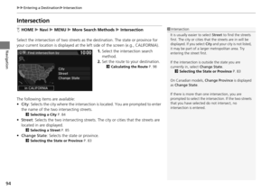 95
95 96
96 97
97 98
98 99
99 100
100 101
101 102
102 103
103 104
104 105
105 106
106 107
107 108
108 109
109 110
110 111
111 112
112 113
113 114
114 115
115 116
116 117
117 118
118 119
119 120
120 121
121 122
122 123
123 124
124 125
125 126
126 127
127 128
128 129
129 130
130 131
131 132
132 133
133 134
134 135
135 136
136 137
137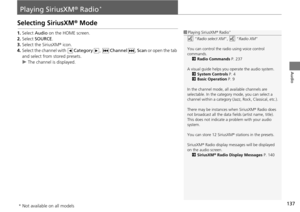 138
138 139
139 140
140 141
141 142
142 143
143 144
144 145
145 146
146 147
147 148
148 149
149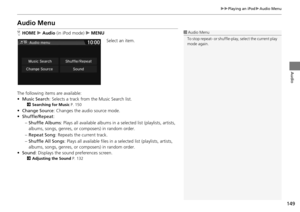 150
150 151
151 152
152 153
153 154
154 155
155 156
156 157
157 158
158 159
159 160
160 161
161 162
162 163
163 164
164 165
165 166
166 167
167 168
168 169
169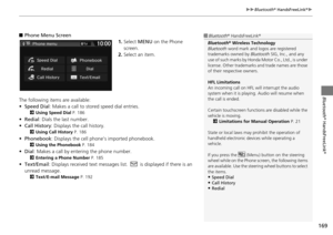 170
170 171
171 172
172 173
173 174
174 175
175 176
176 177
177 178
178 179
179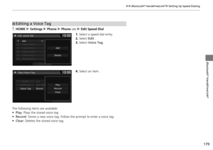 180
180 181
181 182
182 183
183 184
184 185
185 186
186 187
187 188
188 189
189 190
190 191
191 192
192 193
193 194
194 195
195 196
196 197
197 198
198 199
199 200
200 201
201 202
202 203
203 204
204 205
205 206
206 207
207 208
208 209
209 210
210 211
211 212
212 213
213 214
214 215
215 216
216 217
217 218
218 219
219 220
220 221
221 222
222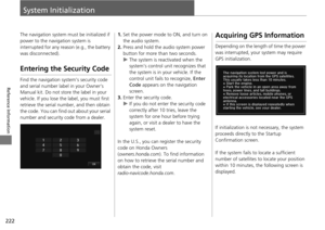 223
223 224
224 225
225 226
226 227
227 228
228 229
229 230
230 231
231 232
232 233
233 234
234 235
235 236
236 237
237 238
238 239
239 240
240 241
241 242
242 243
243 244
244 245
245 246
246 247
247 248
248 249
249