2015 MERCEDES-BENZ SLS AMG GT ROADSTER display
[x] Cancel search: displayPage 87 of 202
regu
lations duringyou rjourney. Roadand
traffic rulesandregulations alwayshave
priority overthenavigation commands
generated bythe system.
COMAND guidesyoutothe destination by
means ofdriving recommen dationsinthe
form ofnavigation announcementsor route
guidance displays.
i The route guidance displaysonly appear
if the display hasbeen switched to
navigation mode.
If, for some reason, youdonot follow the
navigation announcementsor ifyou leave the
calculated route,COMAND automatically
calculates anew route tothe destination .
If the map data contains correspon ding
informat ionduring routeguidance, COMAND
tries toavoid roads withlimited passabil ity,
e.g. roads thatareblocked forthrough-t raffic
and areforresidents only. Driving
Maneuver
Drivin gmaneuvers aregiven inthree phases:
R Preparation phase
R Ann ouncemen tphase
R Maneuver phase
Prepa ration Phase COMAND
preparesyouforthe next driving
maneuver. Basedonthe example display
shown below, theannounc ementismade
using Prepare toturn right .T
he displa y
is not split anddispla ysthe map overthe
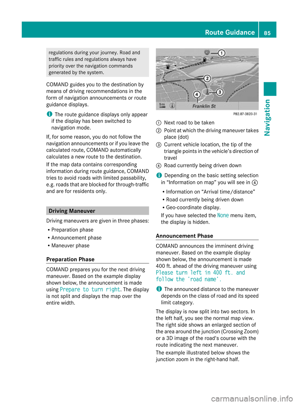
entire width. 1
Next roadtobe taken
2 Point atwhich thedriving maneuver takes
place (dot)
3 Current vehiclelocation, thetipofthe
triangle pointsinthe vehicle’s direction of
travel
4 Road current lybeing driven down
i Depending onthe basic settingselection
in “Inform ationonmap” youwillsee in4
R Inform ationon“Arrival time/distanc e”
R Road current lybeing driven down
R Geo-coordinate display.
If you have selected theNone menu
item,
the displa yis hidden.
Announc ementPhase COMAND
announces theimminent driving
maneuver. Basedonthe example display
shown below, theannouncemen tismade
400 ft.ahead ofthe driving maneuver using
Please turnleftin400 ft.and follow
the’road name’. i
The announced distancetothe maneuver
depends onthe class ofroad anditsspeed
limit category.
The displa yis now split intotwosectors. In
the left half, youseethenormal mapview.
The right sideshows anenlarged sectionof
the area around thejunct ion(Crossing Zoom)
or a3D image ofthe road's course withthe
route indicating thenext maneuver.
The example illustrated belowshows the
junct ionzoom inthe right-hand half. Route
Guidance
85Navigation Z
Page 88 of 202
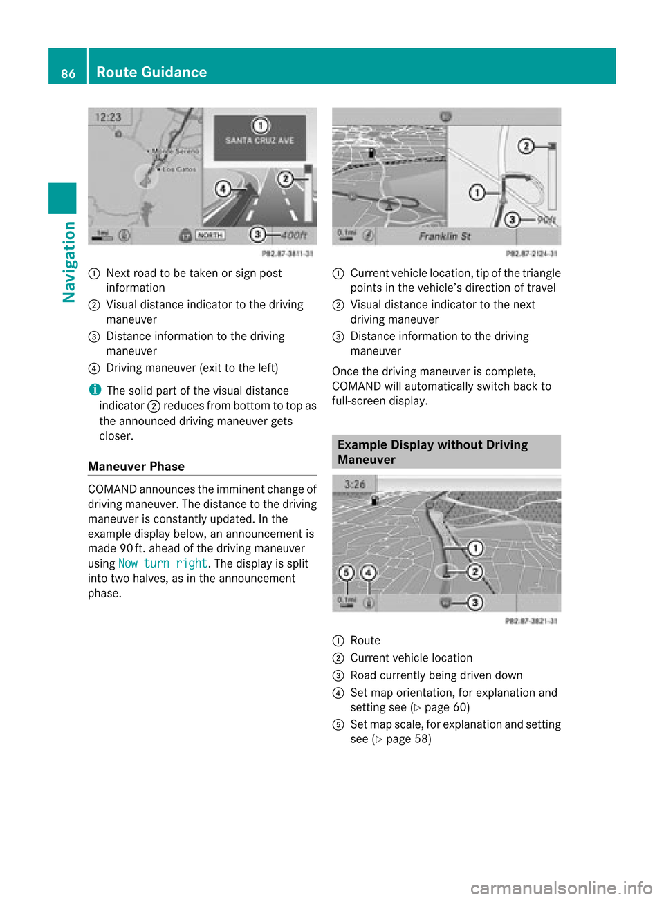
1
Next roadtobe taken orsign post
information
2 Visua ldistance indicator tothe driving
maneuver
3 Distance information tothe driving
maneuver
4 Driving maneuver (exittothe left)
i The solid partofthe visua ldistanc e
indic ator2reduc esfro mb ottom totop as
the announc eddriving maneuver gets
closer.
Maneuver Phase COMAND
announcesthe imminent changeof
driving maneuver. Thedistance tothe driving
maneuver isconst antlyupdated. Inthe
example displaybelow,anannounc ementis
made 90ft.ahead ofthe driving maneuver
using Nowturn right .T
he displa yis split
into twohalves, asinthe announcemen t
phase. 1
Current vehiclelocation, tipofthe triangle
points inthe vehicle’s direction oftravel
2 Visual distance indicator tothe next
driving maneuver
3 Distanc einformation tothe driving
maneuver
Once thedriving maneuver iscomplete,
COMAND willautomatically switchbackto
full-screen display. Example
Displaywithout Driving
Maneuver 1
Route
2 Current vehiclelocation
3 Road current lybeing driven down
4 Set map orientation ,for explanation and
settin gsee (Ypage 60)
5 Set map scale, forexplanation andsettin g
see (Ypage 58) 86
Route
GuidanceNavigat ion
Page 90 of 202
Route
Guidanceto an Off-ro ad
De stin atio n CO
MAND canalso guide yo uto des tina tions
that arewithin theareacovered bythe digital
map, butarenot themselves includedonthe
map. Such destinat ionsareoff-road
destinat ions,which youcan enter ,for
example, byenter ingthe destination viathe
map.
In this case, COMAND guidesyouonroads
known tothe system foraslong aspossible
using navigation announcementsand route
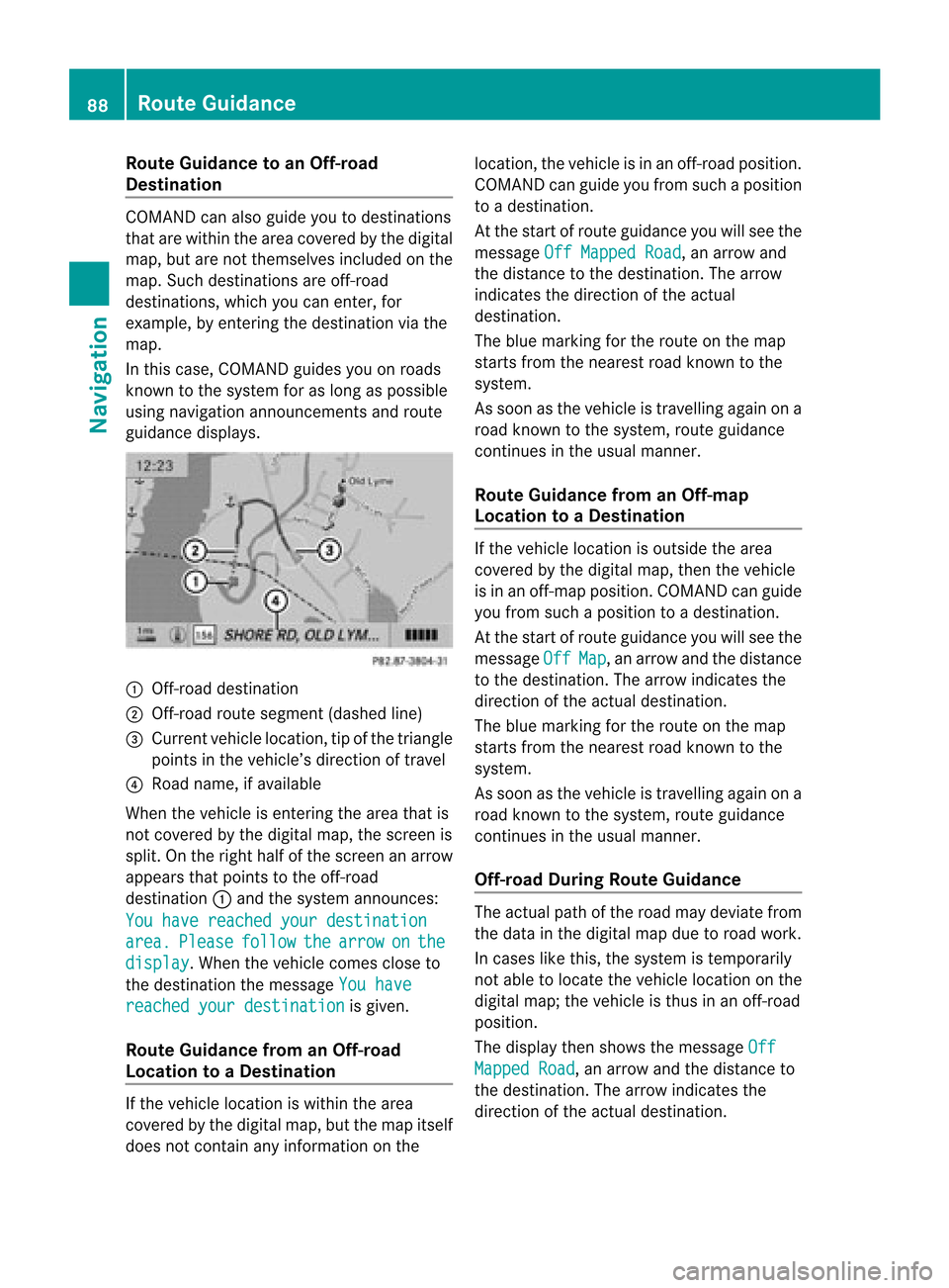
guidance displays. 1
Off- road destinat ion
2 Off- road route segment (dashedline)
3 Current vehiclelocation, tipofthe triangle
points inthe vehicle’s direction oftravel
4 Road name, ifavaila ble
When thevehicle isenter ingthe area thatis
not covered bythe digital map,thescreen is
split. Onthe right halfofthe screen anarrow
appears thatpoints tothe off-road
destinat ion1and thesystem announc es:
You have reached yourdestination area. Please follow the arrow on the
display .W
hen thevehicle comescloseto
the destination themessage Youhave reached
yourdestination is
given.
Route Guidance fromanOff-r oad
Location toaD esti nation If
th eveh icle locat ioniswith inthearea
cov ered bythedigit almap, butthemap itself
does notcon tain anyinform ationon the loc
atio n,thevehi cleisin an off-road posit ion.
COMA NDcan guide youfrom such aposit ion
to adest ination.
At thest art ofrout eguidan ceyou willsee the
mes sage OffMapped Road ,
an arro wand
th edist anceto thedest ination.The arrow
indicates thedirection ofthe actual
destination.
The blue marking forthe route onthe map
starts fromthenearest roadknown tothe
system.
As soon asthe vehicle istravelling againona
road known tothe system, routeguidance
cont inues inthe usua lmanner.
Route Guidance fromanOff-m ap
Location toaD esti nation If
th evehi clelocatio niso uts ide thearea
co ver edbythedigit almap, then theveh icle
is in an off-map posi tion .C OMAND canguide
you from such aposition toadestination.
At the start ofroute guidanceyouwillsee the
message Off Map ,
an arrow andthedistance
to the destination. Thearrow indicates the
direction ofthe actual destination.
The blue marking forthe route onthe map
starts fromthenearest roadknown tothe
system.
As soon asthe vehicle istravelling againona
road known tothe system, routeguidance
continues inthe usualmanner.
Off-road DuringRouteGuidance The
actua lpath ofthe road maydeviatefrom
the data inthe digitalmap duetoroad work.
In cases likethis, thesystem istempora rily
not ableto loca tethe vehicl eloca tion onthe
digi talmap; thevehicl eis thus inan off-road
posi tion.
The displaythen show sthe messa geOff Mapped
Road ,
an arrow andthedista nceto
the destina tion.Thearrow indicatesthe
dire ction ofthe actua ldestina tion. 88
Route
GuidanceNavigatio n
Page 91 of 202
As
soo nasthe vehicle location isfound again,
route guidancecont inues inthe usua l
manner. Navigation
Announcements G
WARNING
Navigation announcement sare intended to
direct youwhile driving without diverting your
attent ionfrom theroad anddriving.
Please alwaysuse this feature instead of
consulting themap displa yfor directions.
Consulting thesymbols ormap displa yfor
directions maycause youtodivert your
attent ionfrom driving andincrease yourrisk
of an accident.
i During anactive telephone call,the
navigation announcement sare
suppressed .
If you have missed anannouncement ,you can
call upthe current announcement atany
time.
X To request currentannounce ment:In
map view withthemenu system
(Y page 58)displa yed,select RPT .
X To switch offnavigation
announce ments:Duringthe
announcement ,press theBbutton.
You willbriefly seethemessage: The driving
instructions havebeen muted .
X To switch navigation announcements
back onmanually: Inmap view withthe
menu system (Ypage 58)displa yed,select
RPT .
or
X Start anew route calcula tion(Ypage 73).
or
X IfCOMAND isswitched onagai northe
engine isrestarted. X
To set the volume ofthe
announcements: Setthevolume during
the automatic announcemen t(Y page 36).
or
X Call upanannouncemen tmanually by
selec tingRPT in
map view withth emen u
syst emdispl ayed.
X Ad jus tthe volume.
Audio Fadeout The
Audio Fadeout function,ifactivated,
lowers thevolume ofthe current audiosource
when anavigation announcemen tisissued.
As soon asthe navigation announcement has
ended, theaudi osource willbeplay edwith
the previous volume(Ypage 36). Cance
lingRoute Guidance
X In the map displa ywith themenu system
displa yed(Ypage 58)select Destination £
Cancel RouteGuidance .
Resuming RouteGuidance X
Select Destination £
Continue Route
Guidance in
map view withthe
menu system displayed.
COMAND calculatesthe route. Detour
Function
i The Detour function blocksaroute
segment ahead.You can setthe length of
the block. COMAND calculates adetour
route ifpossible.
X Select Route £
Detour in
map view with
the menu system displayed.
X To set the length ofblock: Select
Longer or
Shorter repeatedly
untilthe
required lengthisset.
The blocked segment ishighlighted inred/
white onthe map. Shown atthe top ofthe
display isthe length ofthe blocked Rout
eGuida nce
89Navigation Z
Page 92 of 202
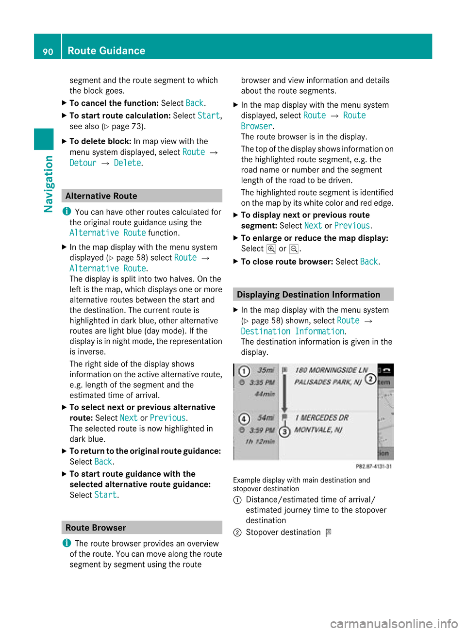
segment
andtheroute segment towhich
the block goes.
X To cance lthe function: SelectBack .
X To start route calculation: SelectStart ,
see also (Ypage 73).
X To delete block:Inmap view withthe
menu system displayed,select Route £
Detour £
Delete .
Alternative
Route
i You canhave other routes calcula tedfor
the original routeguidanceusing the
Alternative Route function
.
X In the map displa ywith themenu system
displa yed(Ypage 58)select Route £
Alternative Route .
The displa yis split intotwohalves. Onthe
left isthe map, which displaysone ormore
alternative routesbetween thestart and
the destination. Thecurrent routeis
highlig htedindark blue, other alternative
routes arelight blue(daymode). Ifthe
displa yis in night mode, therepresentation
is inverse.
The right sideofthe displa yshows
information onthe active alternative route,
e.g. length ofthe segment andthe
estimated timeofarrival.
X To selec tnext orprevious alterna tive
rou te:Sele ctNex t or
Pre vious .
The selec tedrout eis now highlig hted in
dark blue.
X To ret urnto theorigi nalrouteguid ance:
Sele ctBac k .
X To sta rtrou teguid ance withthe
selected alterna tiverou teguid ance:
Sele ctSta rt .
Rou
teBrowser
i The routebrows erprov ides anover view
of therout e.You canmov ealong therout e
segm entbysegm entusin gth erout e brows
erand view inform ationand detai ls
ab ou tthe route segments.
X In the map displa ywith themenu system
displa yed,select Route £
Route Browser .
The route browser isin the displa y.
The topofthe displa yshows information on
the highlighted routesegment, e.g.the
road name ornumber andthesegment
length ofthe road tobe driven.
The highlighted routesegment isidentified
on the map byits white colorandrededge.
X To display nextorprevious route
segment: SelectNext or
Previous .
X To enlarge orreduce themap display:
Select ;or:.
X To close route browser: SelectBack .
Displaying
Destination Information
X In the map displa ywith themenu system
(Y page 58)shown, selectRoute £
Destination Information .
The destination information isgiven inthe
displa y. Example
displaywithmain destination and
stopover destination
1 Distanc e/estimated timeofarrival/
estimated journeytimetothe stopover
destination
2 Stopover destination = 90
Route
GuidanceNavigat ion
Page 93 of 202
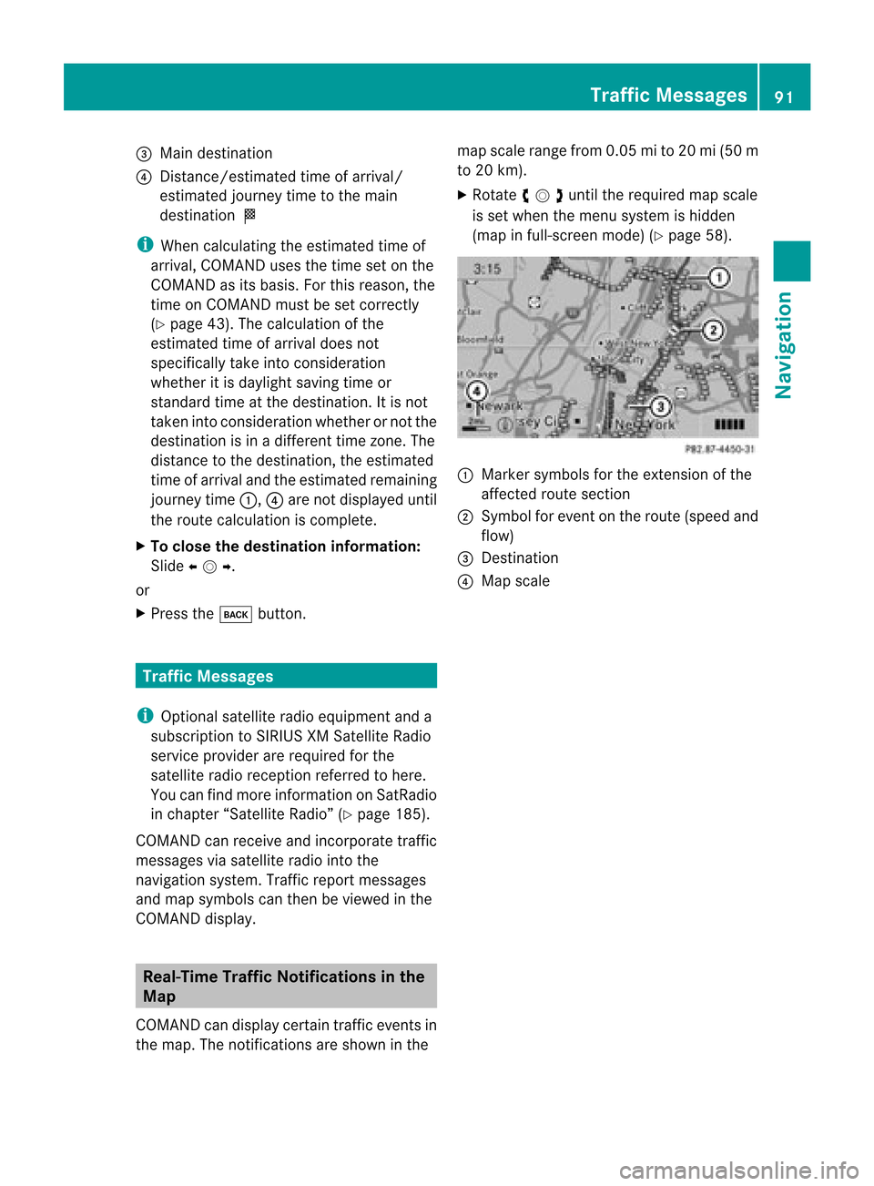
3
Main destination
4 Distanc e/estimated timeofarrival/
estimated journeytimetothe main
destination <
i When calculating theestimated timeof
arrival, COMAND usesthetime setonthe
COMAND asits basis. Forthis reason, the
time onCOMAND mustbeset correct ly
(Y page 43).Thecalculation ofthe
estimated timeofarrival doesnot
specifically takeintoconsideration
whether itis dayl ight saving timeor
standard timeatthe destination. Itis not
taken intoconsideration whetherornot the
destination isin adifferent timezone. The
distance tothe destination, theestimated
time ofarrival andtheestimated remaining
journey time1,4are not displa yeduntil
the route calculation iscomplete.
X To close thedestination information:
Slide omp .
or
X Press thek button . Tr
affic Messages
i Optional satelliteradioequipment anda
subscription toSIRIUS XMSatellite Radio
service provider arerequired forthe
satellite radioreception referredtohere.
You canfind more inform ationonSatRadio
in chapter “Satellite Radio”(Ypage 185).
COMAND canreceive andincorpor atetraffic
messages viasatellite radiointothe
navigation system.Trafficreportmessages
and map symbols canthen beviewed inthe
COMAND display. Real-T
imeTraffic Notificat ionsinthe
Map
COMAND candisplay certaintraffic eventsin
the map. Thenotifications areshown inthe map
scale range from0.05mi to20 mi(50 m
to 20 km).
X Rotate ymzunt ilth ereq uired mapscale
is set when themen usyst emishidde n
(map infull- scree nm ode) (Ypage 58). 1
Marker symbols forthe exten sionofthe
affect edroute section
2 Symbol forevent onthe route (speed and
flow)
3 Dest ination
4 Map scale Tr
affic Messages
91Navigation Z
Page 95 of 202
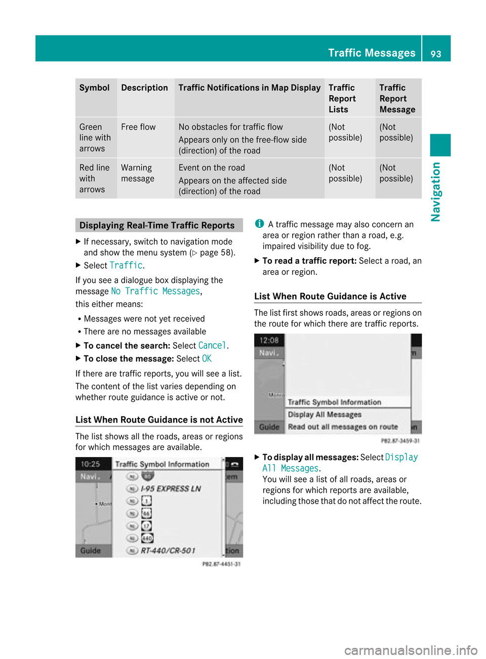
Symbol Desc
ription Tra
ffic Notifications inMap Display Tra
ffic
Report
Lists Tra
ffic
Report
Message Green
line with
arrows Free
flow No
obstacles fortraffic flow
Appears onlyonthe free-flow side
(direction) ofthe road (Not
possible) (Not
possible) Red
line
with
arrows Warning
message Even
ton the road
Appears onthe affected side
(direction) ofthe road (Not
possible) (Not
possible) Displaying
Real-TimeTra ffic Report s
X Ifnecessary, switchtonavigation mode
and show themenu system (Ypage 58).
X Select Traffic .
If you seeadialogu ebox display ingthe
message NoTraffic Messages ,
this either means:
R Messages werenotyetreceived
R There arenomessages available
X To cancel thesearch: SelectCancel .
X To close themessage: SelectOK If
there aretraffic reports, youwillsee alist.
The cont entofthe listvaries depending on
whether routeguidanceisactive ornot.
List When Route Guidance isnot Active The
listshows allthe roads, areasorregions
for which messages areavaila ble. i
Atraffic message mayalsoconc ernan
area orregion ratherthanaroad, e.g.
impaired visibilitydue tofog.
X To read atra ffic report :Select aroad, an
area orregion.
List When Route Guidance isActive The
listfirst shows roads,areasorregions on
the route forwhich therearetraffic reports. X
To display allmessages: SelectDisplay All
Messages .
You willsee alist ofall roads, areasor
regions forwhich reports areavaila ble,
including thosethatdonot affect theroute. Tr
affic Messages
93Navigation Z
Page 96 of 202
X
To dis play atraffi cmes sage:Sel ect a
roa d,area orreg ionf rom thelist.
X To clo sethe list:Slide omponce or
repeatedly.
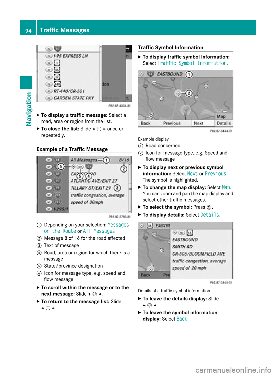
Examp leof aTr affic Message 1
Dependin gon your selection: Messages on
the Route or
All Messages 2
Message 8of 16 for the road affect ed
3 Text ofmessage
4 Road, areaorregion forwhich thereisa
message
5 Stat e/provinc edesignation
6 Icon formessage type,e.g.speed and
flow message
X To scroll within themessage ortothe
next message: Slideqmr .
X To return tothe mes sagelist: Slide
omp Traffi
cSymb olInfo rmatio n X
To dis play traffi csymb olinfo rmatio n:
Sel ect TrafficSym bol Information .
Exam
ple disp lay
1 Road conce rned
2 Icon formes sage typ e,e.g .Speed and
flow message
X To displa ynext orprevious symbol
infor mation :Sele ctNex t or
Pre vious .
The symbo lis highlig hted.
X To chan gethema pdisp lay:SelectMap .
You canzoom and panthemap display and
selec tothe rtraffic messa ges.
X To selectthe symbo l:Press n.
X To display details:Select Detail s .
Detail
sof atraffic symbolinforma tion
X To leav ethe details display: Slide
omp .
X To leave thesymb olinfo rmatio n
dis play :Sel ect Back .94
Traffi
cMe ssage sNavi gation