2015 MERCEDES-BENZ SLS AMG GT COUPE navigation system
[x] Cancel search: navigation systemPage 60 of 202

3
Curr entv ehicle location
4 Navigation submenu Map
without activatedroute guidance andwith
menu system hidden
1 Current vehiclelocation
2 Set map orient ation
3 Set map scale
<0042000900130010000C0001001B0009000E000700220041000900040009000E
0007F MenuSystem X
To hide: Slideqmand whenthemen u
ite mFul lscr een is
displ ayed pressn.
or
X Pre ssthefun ction buttonØ.
The men usyst emishidde n.This displ ays
th emap infull scree nm ode.
X To display: Infull screen mapmode press
n.
Setting MapScale i
You canonly setthe map scale when the
menu system ishidden (mapinfull-screen
mode).
X Rotate ymzunt ilth ereq uired mapscale
is set .
The map scale 3isdisp layed assoo nas
you start rotating ymz .Ro tati ng
clo ckwi semake sthe map smaller, rota ting
anti clockwi seenl arg esit. 1
Currentl yset map scaleas numb er
2 Pointer indicating thecurrentl ysel ected
map scale
3 Scal e
Savi ngCurre ntVehi cle Lo cati onas
De stinati oninthe LastDesti nations X
To dis pla ymen usyst emifap plica ble:
Pres sn.
X To sav e:Sele ctPos ition £
Save Veh
iclePos ition .
COMA NDsaves thecur ren tveh icle
loc atio nasdestination inthe last
destinations memory.Awindow appears
con tain ingacor respo ndingmess age.
X To exit menu :Slide ompor pressthe
k button .
Scrolling theMap i
You canonly scroll themap when the
menu system ishidden (mapinfull-screen
mode).
X Hide menu system ifapplicabl e
(Y page 58).
X Slide qmr ,ompor wmx.
Cros shair swill appear onthemap. 58
Int
rod uctionNavi gatio n
Page 61 of 202

1
Curr entv ehicle location
2 Crosshairs
3 Informat iononcross hairs position
4 Set map scale
i The display item3may forexample be
a road ifcorr espondin gdata isavailable in
the digital mapandCurrent Street is
activat ed.Oritdisplays thegeo-c oordinat e
position ofthe cross hairs ifGeo- coordin
ates display
isactivat ed.
Saving crosshair sposition asdestina tion
in the Last Destinations memory
X To displa ymenu system ifapp licable:
Press n.
X To save: Select Positio n £
Save Crossha
irPositio n .
COMAND savesthecross hairs position as
a destin ationinthe last destin ations
memory. Awindow appears contain inga
cor respo ndingmess age.
Hid ing crossh airs
X Press thek button.
The crosshair sdisappear andthemap is
set tothe vehic lelocat ion.
or
X Set themap tothe vehic lelocat ion,see
desc ription below.
Sett ingMap toVeh icle, Destina tionor
Stop over Location i
Ifyou have movedthe map, youcan
quick lymov ethe map tothe vehic le, dest
inationorstopove rlocation usingthis
funct ion.Itis only possible toset itto the
destination locationwhenrouteguidance
is active.
X To display menusystem ifapp licable:
Press n.
X To set map tovehicle location: Select
Position £
Vehicle Position Map .
This hides thecrosshairs.
or
X Press thek button ifthe crosshairs are
display ed.
This hides thecrosshairs.
X To set the destinat ionlocation: Select
Position £
Destination Position Map .
The crosshairs positionisthen settothe
destination .
X To set the stopover location:Select
Position £
Stopover PositionMap .
The crosshairs positionisthen settothe
stopover. Basic
Settings
You canperform thesettings listed below
with route guidance inactiveoractive.
Route Mode This
funct ionallows youtoset the following
route calculation modesandoptions forroute
guidance:
R Short Route COMAND
calculates aroute byminimizin g
the driving distance withouttakinginto
acount trafficmessages.
R Dynamic Route COMAND
calculates aroute byminimizin g
the driving timeandtakes intoaccount
traffic messages receivedalongtheroute.
The navigation systemthuscanavoid
traffic jamsbyrecalculating theroute
dynamically.
R Dynamic RouteOnlyAfter Request Introdu
ction
59Navigation Z
Page 63 of 202

Exam
ple of ma pfrom bird' s-ey evie w
1 Curre ntcros shairslocati on
2 Curre ntly setmapori enta tion
X To setmap orientatio n:Dis play menu
sy stem ifap plica ble (Y page 60) .
X Sel ect Navi £
Map Display .
Ad otR indicates thecurrent setting. 1
Options formap orient ation
X Select North Up or
Heading Up or
Bird's-eye View .
X To exit menu: Slideomp .
X Hide menu systems ifap plicab le
(Y page 58).
The map orientati onchang esaccor dingly.
Setti ngPOI Symbo ls You
canselect whichPOIs aretobe displa yed
as symbol son the map .Points ofinter ests
include, forexample, gasstation ,hotels,
cinemas andrestaurant s. 1
Options forPOI symbols (Ypage 61).
X To set: Display menusystem ifapplicabl e
(Y page 58).
X Select Navi £
POI Symbols OnMap .
X Select Standard Symbols or
Personal Symbols or
No Symbols .
The settings have thefollowing effect:
R Standard Symbols Displays
thefactor y-setsymbols
R Personal Symbols The
listofPOIs isdisplay ed
R No Symbols No
POI symbols areshown onthe map.
i The listindicates allsymbols forall
count riesthat arecont ained inthe digital
map. However, notallPOIs areavailba lein
all count ries.Asaresult, certainPOI
symbols maynotbeshown onthe map
even though thesymbol displayisswitched
on.
X To exit menu: Slideomp .
X Hide menu system ifap plicab le
(Y page 58).
Traffic Informatio non Map Provi
dedyouhav easub scrip tiontoSIRIU S
XM Satel lite Radio Traffic Mess ageServi ce,
yo ucan havethe traffi cinform ation displ ayed
on the map.The rearethre ediffer ent
cate goriesof info rma tiony ou can select. Introdu
ction
61Navigation Z
Page 65 of 202

Cur
rentSt reet Map
withroad displayact ivat ed
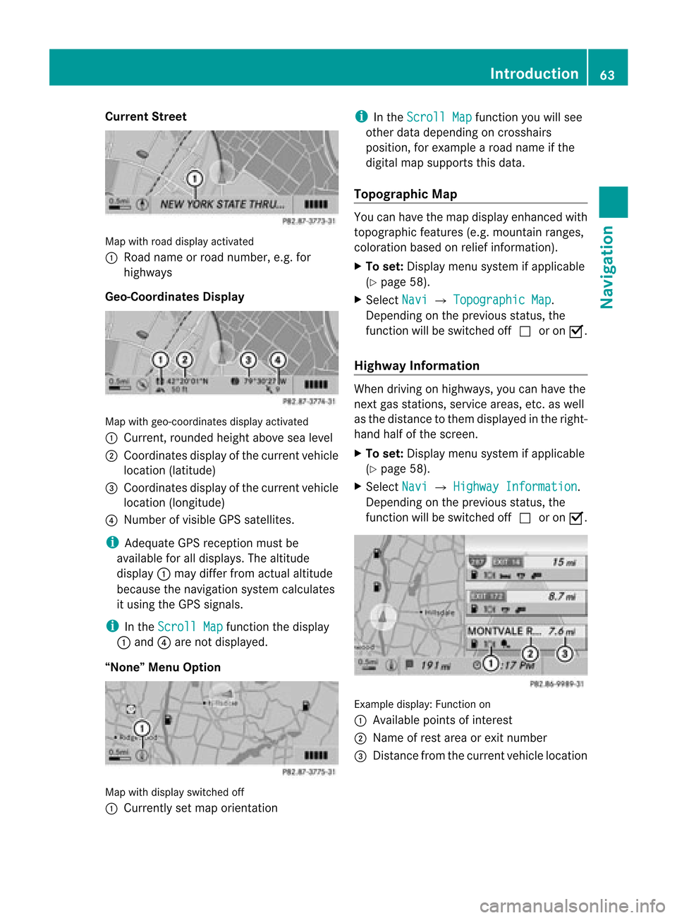
1 Road nameor road number, e.g.for
highway s
Geo-Coordinates Display Map
withgeo-coor dinatesdisplayactivated
1 Current, rounded heightabovesealevel
2 Coordinates displayofthe current vehicle
location (latitude)
3 Coordinates displayofthe current vehicle
location (longitude)
4 Number ofvisible GPSsatellites.
i Adequate GPSreception mustbe
availa bleforalldisplay s.The altitude
display 1may differ fromactual altitude
because thenavigation systemcalculates
it using theGPS signals.
i Inthe Scroll Map funct
ionthe display
1 and 4are not display ed.
“None” MenuOption Map
withdisplay switched off
1 Currently setmap orientat ion i
Inthe Scroll Map funct
ionyou willsee
other datadepending oncrosshairs
position, forexample aroad name ifthe
digital mapsupports thisdata.
Topogra phicMap You
canhave themap display enhancedwith
topographic features(e.g.mountain ranges,
coloration basedonrelief informat ion).
X To set: Display menusystem ifapplicabl e
(Y page 58).
X Select Navi £
Topographic Map .
Dependin gon the previous status,the
funct ionwill beswitched offcor onÇ.
Highway Information When
driving onhighway s,you can have the
next gasstation s,service areas,etc.aswell
as the distance tothem display edinthe right-
hand halfofthe screen .
X To set: Display menusystem ifapplicabl e
(Y page 58).
X Select Navi £
Highway Information .
Dependin gon the previous status,the
funct ionwill beswitched offcor onÇ. Example
display:Functionon
1 Available pointsofinter est
2 Name ofrest area orexit number
3 Distan cefrom thecurrent vehiclelocation Introdu
ction
63Navigation Z
Page 66 of 202

Read
Traffic MessagesAuto matic ally Yo
ucan choo sewh ethe rthe traffic messages
relevant forthe route areread automatically
or whether youhave tostart thereading
manually usingtheTraffic submenu.
X To set: Display menusystem ifappli cable
(Y page 58).
X Select Navi £
Read Traffic Messages
Automatically .
Depending onthe previous status,the
funct ionwill beswitched offcor onÇ.
Audio Fadeout The
Audio Fadeout function,ifactivated,
lowers thevolume ofthe current audiosource
when anavigation announcemen tisissued.
As soon asthe navigation announcement has
ended, theaudi osource willbeplay edwith
the previous volume.
X To activate: Displaymenusystem if
appli cable (Ypage 58).
X Select Navi £
Audio Fadeout .
Depending onthe previous status,the
function willbeswitched offcor onÇ. Block
Area
You candefine anarea within themap displa y
that isnot tobe used bythe system in
calcula tingaroute, ifpossible .
i The calcula tedroute mayinclude a
blocked areaifthe destination iswithin a
blocked areaorifthe destination canonly
be reached usingroads thatlead through a
blocked area.Highway scannot beblocked.
X To set, change ordelete: Displaymenu
system ifappli cable (Ypage 58).
X Select Navi £
Block Area .
If no areas werepreviousl yset, the map
display appears readytoselect anarea. If
areas werepreviously set,theblocked area
list appears.
X To set the map scale: Rotate ymz. X
To scrol lthe map: Slideqmr ,omp or
wmx .
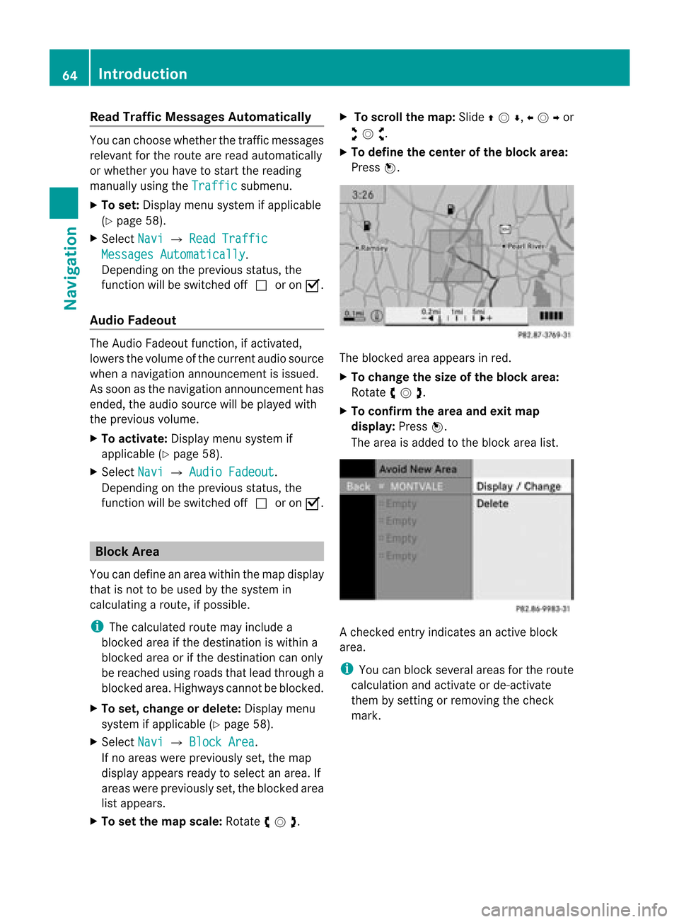
X To def inethe cente rof the bloc karea :
Pre ssn. The
blocke dar ea appe arsin red .
X To chang ethe size ofthe bloc karea :
Ro tate ymz .
X To confi rm the area andexitmap
dis play :Pre ssn.
The area isad de dto the block area list. A
che cked entry indicates anacti veblock
ar ea .
i Youcan block severalar ea sfor the route
cal cul ation and activate or de-acti vate
them bysetti ngorrem oving the check
ma rk. 64
In
troduc tionNavi gation
Page 67 of 202

Disp
laying andC hangi nganExisting
Bloc kArea X
To select the areayo uwa nttodis pla y
or chang e:Slide qmr .
X Sel ect Option s £
Display/Change .
The map displ ayappe ars with the block
are amar ked red.
X To setthe map scale :Ro tate ymz .
X To scrol lthe map: Slideqmr ,omp or
wmx .
X To def inethe cente rof the bloc karea :
Pre ssn.
X To setthe desi redsize ofthe blockarea:
Rota teymz .
X To confi rm the area andexitmap
dis play :Pre ssn.
X Hid emenu system ifap plica ble
(Y page 58) .
De finingaN ew Block Area
X Sele ctOpt ion s £
AvoidNew Area The
map isdisplayed.
X To set thema pscale: Rotateymz .
X Rot ate ymzunt ilth edesi redsizeof the
ne wbloc karea isset.
X Slide qmr ,ompor wmxtoshiftthe
new block area tothe desired region.
X To confi rm the areaand exitmap
dis pla y:Pre ssn.
X Hid emenu syste mifapplicable
(Y page 58).
Deleting aBlock Area
X To select thear ea you want todelet e:
Slide qmr .
X Sel ect Option s £
Delete .
Yo uwi llbe pro mpte dto confi rmthatyou
wish todelete theblock area.
X Select Yes or
No .
If you select Yes COMAND
deletesthe
entr y. SIRIUS
XMTraffic Service
You candisplay theSIRIUS XMServic e
informat ion.
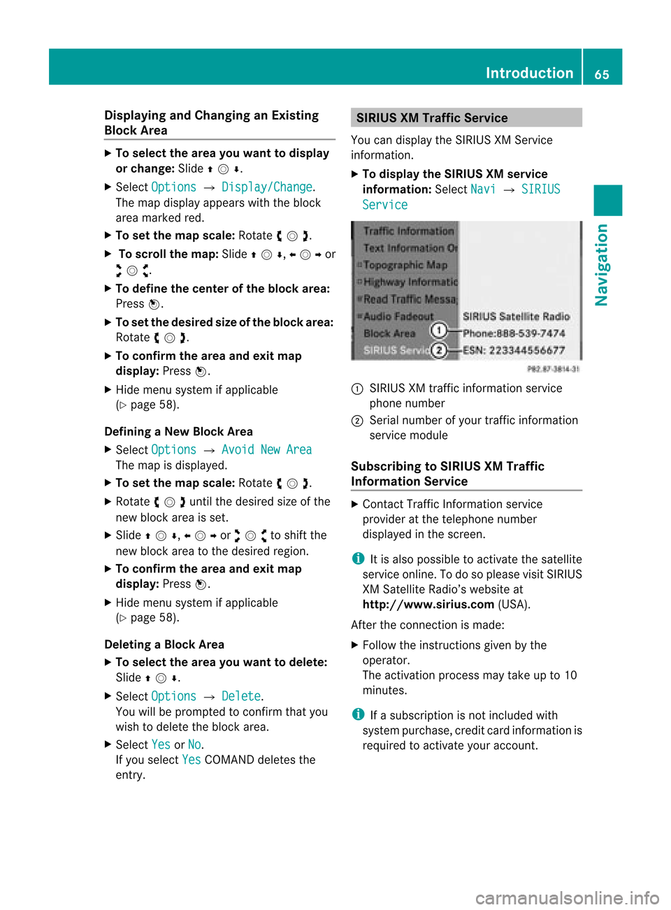
X To display theSIRIUS XMservice
informa tion:Select Navi £
SIRIUS Service
:
SIRIUS XMtraffic informat ionservice
phone number
; Serial number ofyour traffic informat ion
service module
Subscribing toSIRIUS XMTraffic
Informat ionService X
Contact TrafficInformation service
provider atthe telephone number
display edinthe screen .
i Itis also possible toactivate thesatellite
service online.Todo soplease visitSIRIUS
XM Satellite Radio’swebsite at
htt <0010002D00220022001700170017002100130009001200090015001300210003
000F000DF (USA).
Aft erthe conn ection ismade:
X Follow theinstr uctions givenbythe
operator.
The activation processmaytake upto10
minutes.
i Ifasubscription isnot included with
system purchase, creditcardinform ationis
required toactivate youraccount . Introdu
ction
65Navigation Z
Page 68 of 202

Dest
ination Inp ut Int
rodu cti on toDest ination Inp ut G
WAR
NING
Fo rs afet yreas ons,on lyent eranew
dest inationwhen theveh icle isstatio nary.
i Itis poss ibletoent erad estin ation
regardless ofwhether routeguidance is
active orinact ive.
The following destinationentryoption sare
available:
R En terin gadestin ationviathe address
(Y page 66)
R En terin gadestin ationfromthedestin ation
memory (Ypage 74)
R En terin gadestin ationfromthelast
destin ations (Ypage 75)
R En terin gaPOI (Ypage 78)
R En terin gadestin ationviathe map
(Y page 75)
R En terin gastopov erdestin ation
(Y page 76)
R En terin gadestin ationvia“Searc h&S end”
(Y page 77) Entering
aDesti nation viathe
Add ress
i Insom ecoun tries itis no tp ossible to
enter addresses atvehicle speeds above
approx. 3mph (approx. 5km/ h).The
funct ionbecomes availableagain assoon
as the speed fallsbelow approx. 2mph
(approx. 3km/ h).
The following optionsare available for
ent ering adestin ationviaanaddress:
R En terin gstat e/prov ince,city/zip codeand
str eet
R En terin gstat e/prov ince,cityand city
cen ter
R En terin gstat e/prov ince,city/zip codeand
str eet and house number R
En terin gstat e/prov ince,city/zip codeand
str eet and junction
R En terin gstr eet, state/prov ince,city/zip
code andhouse number
Route calculation canthen bestart ed
(Y page 73).
Opening EnterDestinat ionMenu X
Ifnec essary switchto navigat ionmode and
display menusystem (Ypage 57).
X Select Destin ation £
Addres sEntry .
The Enter Dest ination menuappears. En
ter Dest ination menu
Menu Items inEnter Destinat ionMenu Some
menuitemsarenot available ornot yet
available, dependingon the address items
ent ered forthe address orthe data forthe
digital map.
Ex ample:
Aft erthe state/prov incehasbeen select ed
the menu itemsNo. ,
Center ,
Inters ection ,
Save and
Start are
not available. Orthe
ZIP menu
itemisnot available ifthe digital
map does notcontain anyzipcodes.
Selecting aState/ Provinc e i
Youcan onlyse lect thos esta tes/
pro vinces thatare stored inthe digitalmap.
X Select State/Pr ov in
the Enter
Destination menu.
Am enu appears whereyoucan choose one
of the following lists: 66
Destination
InputNavigation
Page 78 of 202

3
Information oncrosshai rspositio n
4 Set map scale
i The display3depe ndsonthe settings
selected in“Text information OnMap”
(Y page 62).Itmay displaythe current road
if corresponding dataisavai lablein the
digi talmap. Oritdisp laysthe geo-
coordinates positionofthe crosshairs if
Geo-coordinates display is
activated.
Moving theMap andSelec tinga
Destination X
To move themap :Slide qmr ,ompor
wmx .
X To setthe map scale :Ro tate ymz .
Rot ating clo ckwise makesthemap smaller ,
rot ating count erclockwi seenlarg esit.
X To select adesti nation: Pressn onc eor
repeat edlyuntilth eEn ter Des tinatio n
men uis displayed or,ifCOMA NDcannot
defin eadest inationunam biguously, alist
of poss ibledest inations. X
To select adesti nation: Rotat eymzor
slide qmr .
X Press n.
If the destinat ioniswithin thedigital map,
COMAND triestofind thedestinat ionon
the map.
If the destinat ioncan befound, theEnter
Dest ination menuisdisplaye dwith the
address ofthe destinat ion.Otherwise youwill
see theentryDestinati onFrom Map .
X To star trout ecalculation: SelectStart .
Entering
Stopover Destination
i When routeguidance isactivat e,you can
ent erastopover destination.Stopover
destinat ionsmay bepredefined
destinat ionsinthe following categories
suggested byCOMAND foryou toselect:
R ATM/Cash Machine R
Hospital R
Gas Station R
Parking Lot R
Restauran t However,
youcan also enterdestinat ions
other thanthose thathave been
predefined. Selectthemenu itemOther for
this purpose.
You caninfluenc ethe route guidance tothe
main destinat ioninaspecific wayusing the
stopover function.Oncethe stopover
destinat ionhas been reached, COMAND
automatically continues theroute guidance
to the main destinat ion.
Entering Predefined Destinations X
Ifnecess aryswitch tonavigation modeand
display menusystem (Ypage 57).
X Select Destinati on £
Stopover .
No Stopover Destination availabl eyet
X Select acategory.
A St opover Destination exists
X Select Change Stopover to
change.
X Select acategory.
X Select another stopover destination.
COMAND firstsearches fordestinat ions
along theroute within theselected category.
COMAND thensearches fordestinat ionsin
the vicinit yof the vehicle's location. 76
Destination
InputNavigation