Page 170 of 236
6-10
UVO eServices(Optional)
My POIs
Sending Points of Interest to
Your Navigation System
Press the key.
Press Info/UVO icon on the touch
screen.
Press the My POIs icon on the touch
screen.
Press Update button on the touch screen.
UVO eServices system will attempt to
download the POIs from MyUVO via your
smartphone.
Page 171 of 236
UVO eServices
Information l
6-11
NOTICE
• Ensure that you have logged in to the
UVO eServices app, and your phone is
connected to the UVO eServices system
via Bluetooth connection.
Once the POIs have been downloaded,
select a POI from the list to see more
details.
Parking Minder
Sending Parking Location
The location where your vehicle is
currently parked can be sent to your
smartphone.
The Parking Minder feature is only
available when the ignition is turned on
and the vehicle is parked.
Ensure that the UVO eServices system
is activated and the Registered Phone
is connected via Bluetooth with the UVO eServices app running on your
smartphone before using this feature. After parking the vehicle, pre
ss the
key, then press Info/UVO
icon on the touch screen.
Press the Parking Minder icon on
the touch screen to send the vehicle ’s
location to your smartphone.
Page 172 of 236
6-12
UVO eServices(Optional)
Once the parking location has been sent,
you can view your vehicle’s location from
the UVO eServices app on your smart-
phone.
NOTICE
• When the parking location is being sent,
do not drive the vehicle or turn off the igni-
tion Ensure that you have logged in to the
UVO eServices app, and your phone is
connected to Navigation System through
Bluetooth connection.
Roadside Assist
Roadside Assist
If a diagnostics issue is found, you can
connect with a Roadside Assist agent.
The Roadside Assist feature can be used
only when your phone is connected via
Bluetooth.
Press the
key, then press
Info/UVO icon on the touch screen.
Page 173 of 236
UVO eServices
Information l
6-13
Press the Roadside Assist icon on the
touch screen to connect with a Roadside
Assist agent.eServices Guide
eServices Guide
eServices Guide provides guidance on
how to use UVO eServices.
This feature is only available when the
mobile phone is connected via Bluetooth.
P r e s s t h e
k e y , t h e n p r e s s
Info/UVO icon on the touch screen.
Press the eServices Guide icon on the
touch screen to connect with a Roadside
Assist agent.
Page 174 of 236

6-14
UVO eServices(Optional)
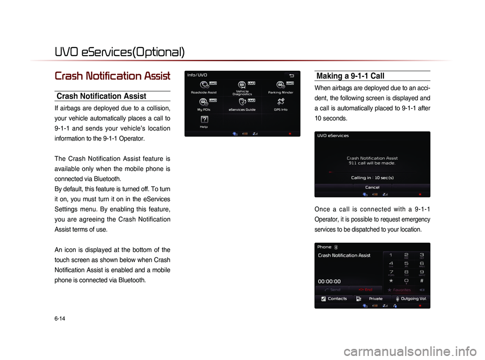
Crash Notification Assist
Crash Notification Assist
If airbags are deployed due to a collision,
your vehicle automatically places a call to
9-1-1 and sends your vehicle’s location
information to the 9-1-1 Operator.
The Crash Notification Assist feature is
available only when the mobile phone is
connected via Bluetooth.
By default, this feature is turned off. To turn
it on, you must turn it on in the eServices
Settings menu. By enabling this feature,
you are agreeing the Crash Notification
Assist terms of use.
An icon is displayed at the bottom of the
touch screen as shown below when Crash
Notification Assist is enabled and a mobile
phone is connected via Bluetooth.
Making a 9-1-1 Call
When airbags are deployed due to an acci-
dent, the following screen is displayed and
a call is automatically placed to 9-1-1 after
10 seconds.
O n c e a c a l l i s c o n n e c t e d w i t h a 9 - 1 - 1
Operator, it is possible to request emergency
services to be dispatched to your location.
Page 175 of 236
UVO eServices
Information l
6-15
The 9-1-1 Operator may request information
on the current location of your vehicle.
When the 9-1-1 Operator requests your
vehicle location, “Sending Location” is dis-
played on the screen and the vehicle location
is automatically sent to the 9-1-1 Operator.When the 9-1-1 consultant attempts to call
the driver again, the call time is displayed
and allows the driver to speak with the
9-1-1 operator.
Page 176 of 236

6-16
About GPS (Global Po-
sitioning System)
GPS (Global Position System) :
GPS is a system developed and operated
by the United States that determines the
user’s current position (longitude, latitude,
etc.) by using 4 or more satellites.
This system is used with related GPS infor-
mation, various sensors, road map data,
and other related information to provide
navigation services.
i Information
• For continued map updates, information-
gathering and surveys are conducted con-
tinuously to monitor road changes or new
road constructions. Nonetheless, roads,
facilities, and fares are under constant
change and it is impossible to completely
remove all errors, including road updates,
names, facilities, and fares. Please keep
this in mind when using GPS.
• In principle, roads with widths less than
3 yards are not included within the map
data. Roads with sections with widths less
than 3 yards may be deleted in future map
data updates.
When GPS Info Cannot Be Used
GPS info may not operate under the fol-
lowing conditions :
• W h e n b u i l d i n g s , t u n n e l s , o r o t h e r
obstructions block satellite signals.
• When materials are placed above the
GPS antenna and block satellite signals.
• When the satellite is not transmitting.
• When a digital cellular phone (1.5GHz)
is placed near the GPS antenna.
Errors Unavoidable Due to Sys-
tem Characteristics
• The navigation system uses GPS infor-
mation, various sensors, road map data,
and other related information to display
the current position.
• Errors may occur if the satellite is trans-
mitting inaccurate signals or only two or
less satellite signals can be received.
• Errors that occur in such conditions can-
not be corrected.
GPS Information
Page 177 of 236
GPS Information
Information l
6-17
Viewing GPS Info
Press the key
▶ Press
Info/UVO ▶ Press GPS Info
i Information
• UVO eServices are an optional feature
equipped in select vehicles
The GPS reception and vehicle speed
information are displayed.