Page 92 of 236
3-10
Map Menu
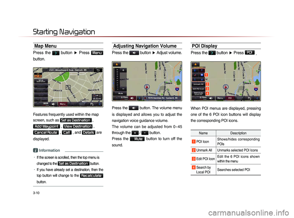
Press the > button ▶ Press Menu
button.
Features frequently used within the map
screen, such as
Set as Destination ,
Add Waypoint , View Destination ,
Cancel Route , Call , and Details are
displayed.
i Information
• If the screen is scrolled, then the top menu is
changed to the
Set as Destination button.
• If you have already set a destination, then the
top button will change to the
Recalculate
button.
Adjusting Navigation Volume
Press the button ▶ Adjust volume.
Press the button. The volume menu
is displayed and allows you to adjust the
navigation voice guidance volume.
The volume can be adjusted from 0~45
through the
+ / - button.
Press the
Mute button to turn off the
sound.
POI Display
Press the > button ▶ Press POI
.
When POI menus are displayed, pressing
one of the 6 POI icon buttons will display
the corresponding POI icons.
Name Description
1 POI IconShows/hides corresponding
POIs
2 Unmark All Unmarks selected POI Icons
3 Edit POI Icon Edit the 6 POI icons shown
within the menu
4 Search by
Local POI Searches selected POI
Starting Navigation
1
2
3
4
Page 98 of 236
3-16
Using the Navigation
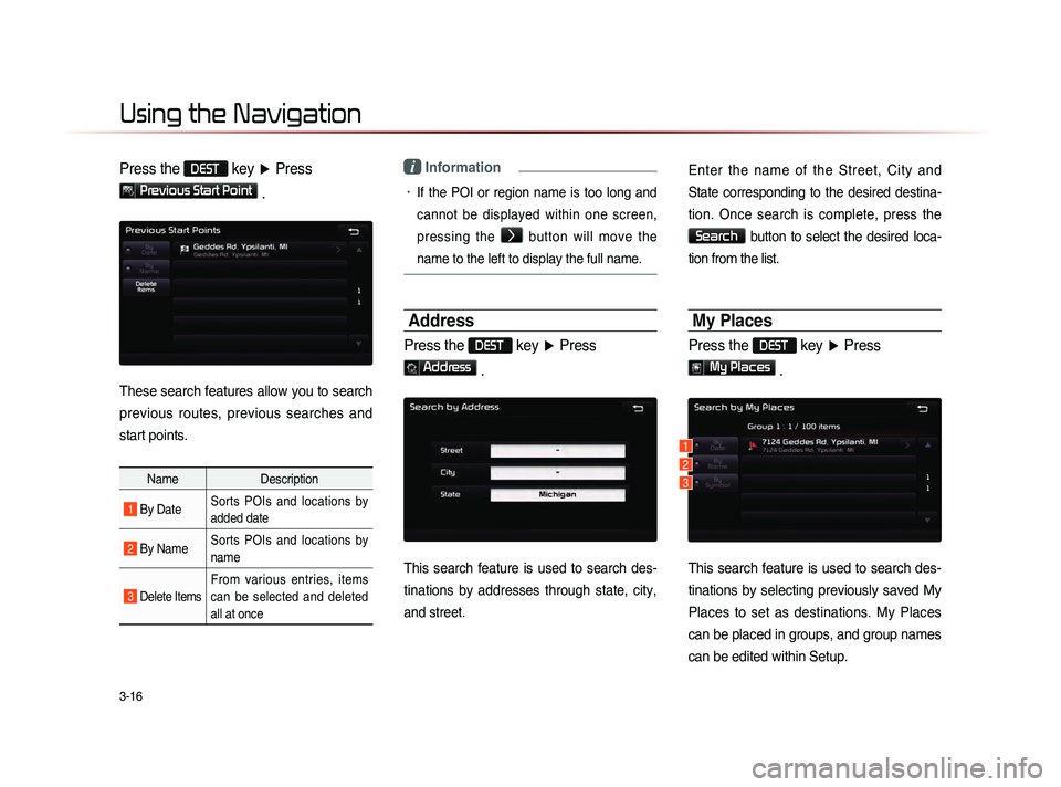
Press the DEST key ▶ Press
Previous Start Point
.
These search features allow you to search
previous routes, previous searches and
start points.
Name Description
1 By DateSorts POIs and locations by
added date
2 By NameSorts POIs and locations by
name
3 Delete Items
From various entries, items
can be selected and deleted
all at once
i Information
• If the POI or region name is too long and
cannot be displayed within one screen,
pressing the
>
button will move the
name to the left to display the full name.
Address
Press the DEST key ▶ Press
Address
.
This search feature is used to search des-
tinations by addresses through state, city,
and street.
Enter the name of the Street, City and
State corresponding to the desired destina-
tion. Once search is complete, press the
Search button to select the desired loca-
tion from the list.
My Places
Press the DEST key ▶ Press
My Places
.
This search feature is used to search des-
tinations by selecting previously saved My
Places to set as destinations. My Places
can be placed in groups, and group names
can be edited within Setup.
1
2
3
Page 99 of 236
Using the Navigation
Navigation l
3-17
Name Description
1 By Date Sort POIs and locations by date
2 By NameS o r t P O I s a n d l o c a t i o n s b y
name
3 By SymbolSort POIs and locations by sym-
bol
i Information
• If the POI or region name is too long and
cannot be displayed within one screen,
pressing the
> button will move the
name to the left.
• It is possible to save up to 100 My Places
per Group.
Intersection Search
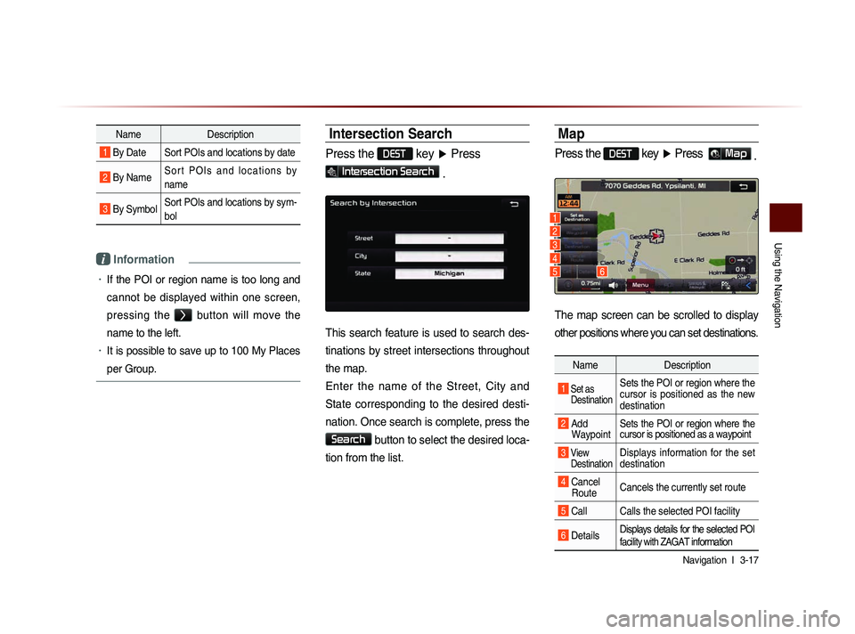
Press the DEST key ▶ Press
Intersection Search .
This search feature is used to search des-
tinations by street intersections throughout
the map.
Enter the name of the Street, City and
State corresponding to the desired desti-
nation. Once search is complete, press the
Search button to select the desired loca-
tion from the list.
Map
Press the DEST key ▶ Press Map .
The map screen can be scrolled to display
other positions where you can set destinations.
Name Description
1 Set as
Destination Sets the POI or region where the
cursor is positioned as the new
destination
2 Add Waypoint Sets the POI or region where the
cursor is positioned as a waypoint
3 View
Destination Displays information for the set
destination
4 Cancel Route Cancels the currently set route
5 Call Calls the selected POI facility
6 DetailsDisplays details for the selected POI
facility with ZAGAT information
1
2
3
4
56
Page 101 of 236
Using the Navigation
Navigation l
3-19
i Information
• The phone number and location may
differ for some POIs. In addition, the fol-
lowing types of facilities may be more
frequently located in other locations.
• Locations of department stores, muse-
ums, and amusement parks may some-
w h a t d i f f e r f r o m t h e s e t d e s t i n a t i o n .
Check the exact address when trying to
reach such destinations.
• Within general information newspapers,
there are cases when phone numbers of
concert halls actually list the numbers of
management companies. In such cases,
destination searches will be made to the
management companies.
• The telephone number and addresses
may change at any time.
Exit/Entrance
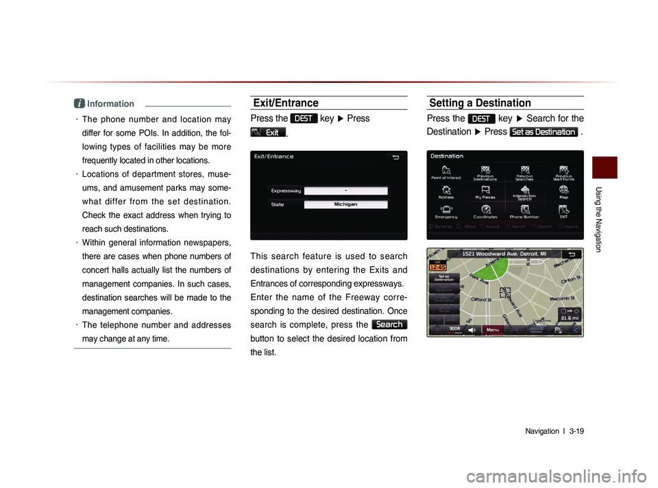
Press the DEST key ▶ Press
Exit.
This search feature is used to search
destinations by entering the Exits and
Entrances of corresponding expressways.
Enter the name of the Freeway corre-
sponding to the desired destination. Once
search is complete, press the
Search
button to select the desired location from
the list.
Setting a Destination
Press the DEST key ▶ Search for the
Destination ▶ Press
Set as Destination .
Page 109 of 236
Using the Navigation
Navigation l
3-27
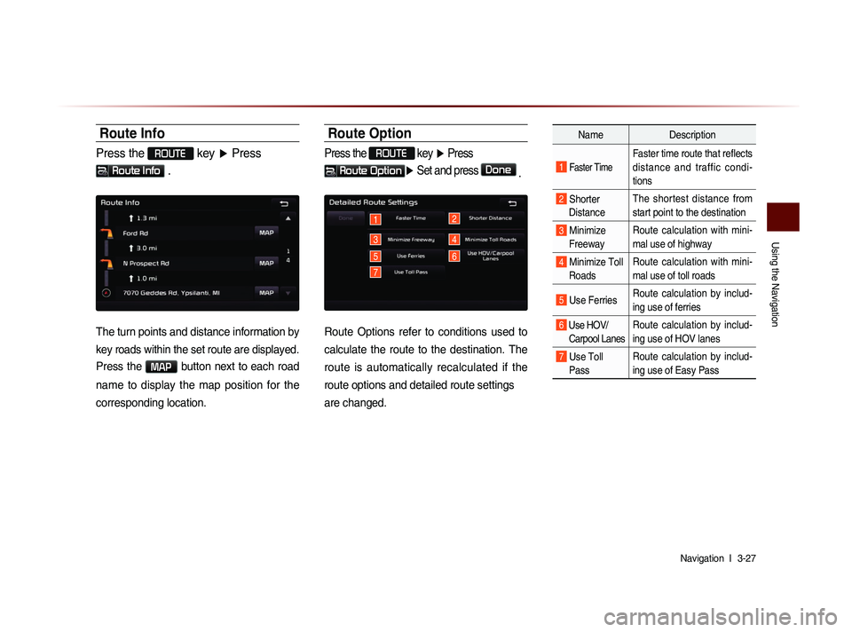
Route Info
Press the ROUTE key ▶ Press
Route Info .
The turn points and distance information by
key roads within the set route are displayed.
Press the MAP button next to each road
name to display the map position for the
corresponding location.
Route Option
Press the ROUTE
key ▶ Press
Route Option▶ Set and press Done
.
1
3
5
2
4
7
6
Route Options refer to conditions used to
calculate the route to the destination. The
route is automatically recalculated if the
route options and detailed route settings
are changed.
Name Description
1 Faster Time
Faster time route that reflects
distance and traffic condi-
tions
2 Shorter
Distance The shortest distance from
start point to the destination
3 Minimize
Freeway Route calculation with mini-
mal use of highway
4 Minimize Toll
Roads Route calculation with mini-
mal use of toll roads
5 Use Ferries
Route calculation by includ-
ing use of ferries
6 Use HOV/
Carpool LanesRoute calculation by includ-
ing use of HOV lanes
7 Use Toll Pass Route calculation by includ-
ing use of Easy Pass
Page 110 of 236
3-28
Using the Navigation
Detour
Press the ROUTE key ▶ Press
Detour .
The Detour menu is used to redefine the
route by setting a detour to a certain dis-
tance from the current position.
Avoid Streets
Press the ROUTE key ▶ Press
Avoid Streets ▶ Select the streets
you want to avoid and press
Done .
This feature is used to select specific
streets to avoid within the current route.
Select
Avoid to avoid the particular
streets in the route overview that are
desired to be avoided.
Edit Route
Press the ROUTE key ▶ Press
Edit Route ▶ Set and press Done
.
The Edit Route menu displays the start
point, waypoints, and the destination in list
format and is used to edit corresponding
positions or the order of destinations within
the route.
Page 130 of 236
4-16
Using Bluetooth® Wireless Technology
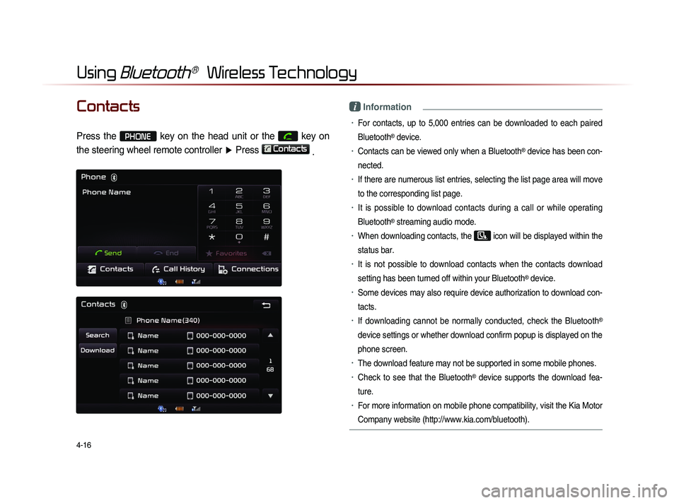
Contacts
Press the PHONE key on the head unit or the
key on
the steering wheel remote controller ▶ Press
Contacts
.
i Information
• For contacts, up to 5,000 entries can be downloaded to each paired
Bluetooth
® device.
• Contacts can be viewed only when a Bluetooth® device has been con-
nected.
• If there are numerous list entries, selecting the list page area will move
to the corresponding list page.
• It is possible to download contacts during a call or while operating
Bluetooth
® streaming audio mode.
• When downloading contacts, the icon will be displayed within the
status bar.
• It is not possible to download contacts when the contacts download
setting has been turned off within your Bluetooth
® device.
• Some devices may also require device authorization to download con-
tacts.
• If downloading cannot be normally conducted, check the Bluetooth®
device settings or whether download confirm popup is displayed on the
phone screen.
• The download feature may not be supported in some mobile phones.
• Check to see that the Bluetooth® device supports the download fea-
ture.
• For more information on mobile phone compatibility, visit the Kia Motor
Company website (http://www.kia.com/bluetooth).
Page 157 of 236
Voice Command Lists
Voice Recognition l
5-15
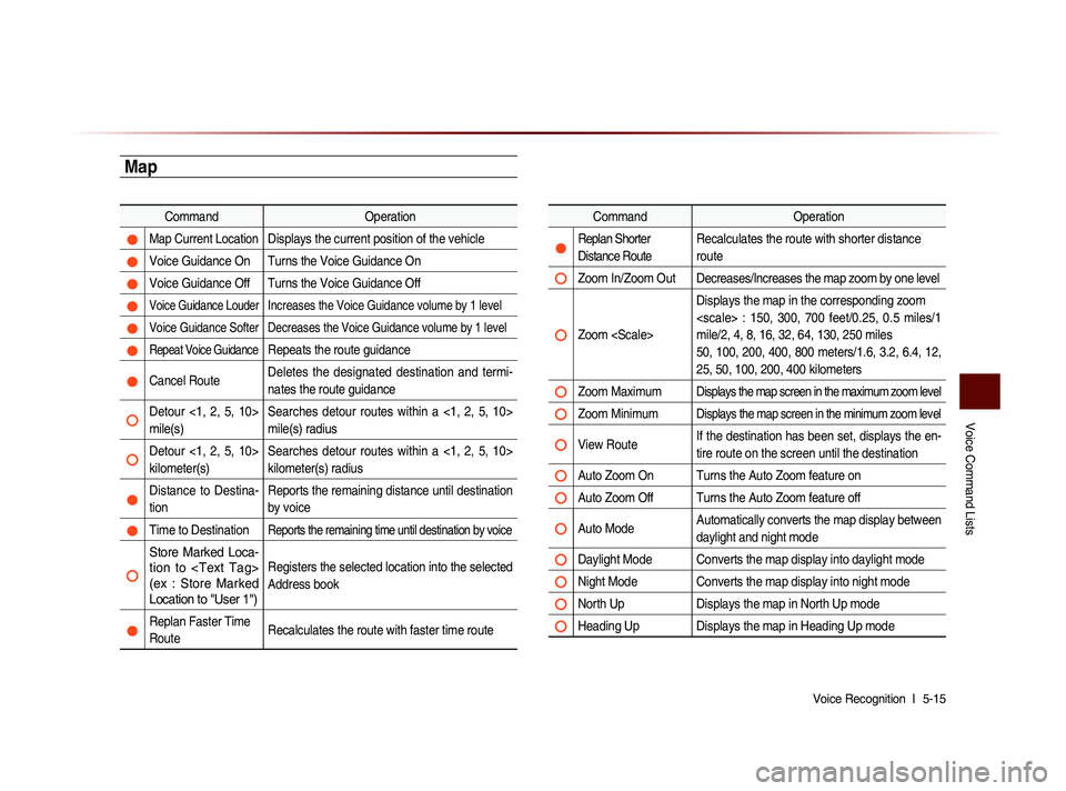
Map
Command Operation
Map Current Location Displays the current position of the vehicle
Voice Guidance On Turns the Voice Guidance On
Voice Guidance Off Turns the Voice Guidance Off
Voice Guidance Louder Increases the Voice Guidance volume by 1 level
Voice Guidance Softer Decreases the Voice Guidance volume by 1 level
Repeat Voice Guidance Repeats the route guidance
Cancel Route Deletes the designated destination and termi-
nates the route guidance
Detour <1, 2, 5, 10>
mile(s) Searches detour routes within a <1, 2, 5, 10>
mile(s) radius
Detour <1, 2, 5, 10>
kilometer(s) Searches detour routes within a <1, 2, 5, 10>
kilometer(s) radius
Distance to Destina-
tion Reports the remaining distance until destination
by voice
Time to Destination Reports the remaining time until destination by voice
Store Marked Loca-
tion to
(ex : Store Marked
Location to "User 1")Registers the selected location into the selected
Address book
Replan Faster Time
Route
Recalculates the route with faster time route
Command
Operation
Replan Shorter
Distance RouteRecalculates the route with shorter distance
route
Zoom In/Zoom Out Decreases/Increases the map zoom by one level
Zoom Displays the map in the corresponding zoom
: 150, 300, 700 feet/0.25, 0.5 miles/1
mile/2, 4, 8, 16, 32, 64, 130, 250 miles
50, 100, 200, 400, 800 meters/1.6, 3.2, 6.4, 12,
25, 50, 100, 200, 400 kilometers
Zoom MaximumDisplays the map screen in the maximum zoom level
Zoom MinimumDisplays the map screen in the minimum zoom level
View Route
If the destination has been set, displays the en-
tire route on the screen until the destination
Auto Zoom On Turns the Auto Zoom feature on
Auto Zoom Off Turns the Auto Zoom feature off
Auto Mode Automatically converts the map display between
daylight and night mode
Daylight Mode Converts the map display into daylight mode
Night Mode Converts the map display into night mode
North Up
Displays the map in North Up mode
Heading Up Displays the map in Heading Up mode