2013 NISSAN LEAF navigation
[x] Cancel search: navigationPage 227 of 275
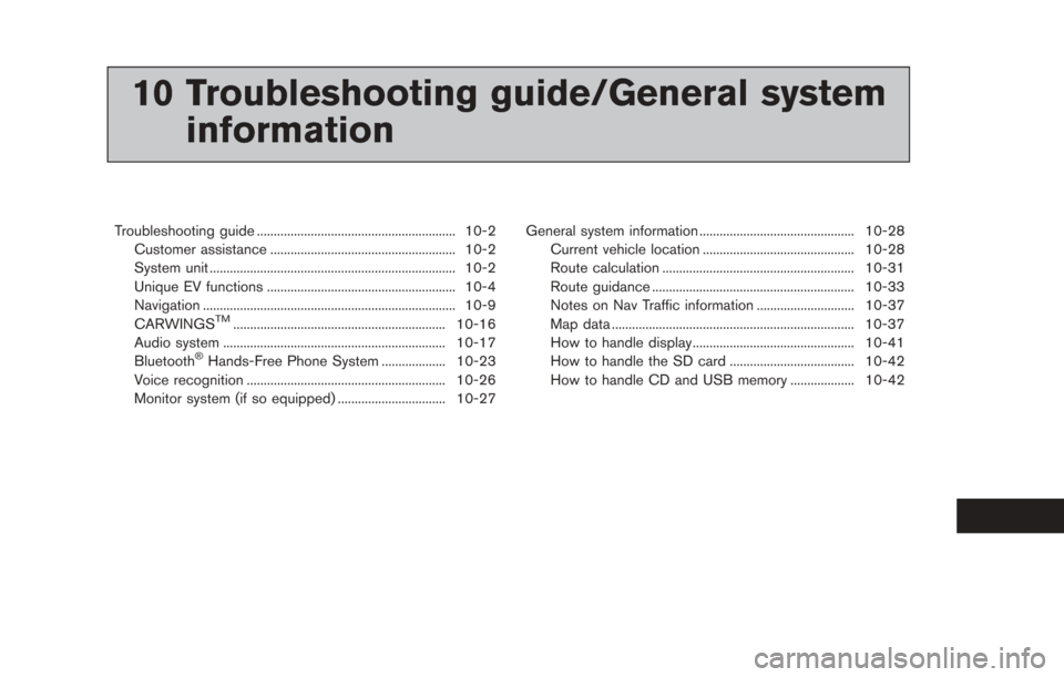
10 Troubleshooting guide/General systeminformation
Troubleshooting guide ........................................................... 10-2
Customer assistance ....................................................... 10-2
System unit ........................................................................\
. 10-2
Unique EV functions ........................................................ 10-4
Navigation ........................................................................\
... 10-9
CARWINGS
TM............................................................... 10-16
Audio system .................................................................. 10-17
Bluetooth
®Hands-Free Phone System ................... 10-23
Voice recognition ........................................................... 10-26
Monitor system (if so equipped) ................................ 10-27 General system information .............................................. 10-28
Current vehicle location ............................................. 10-28
Route calculation ......................................................... 10-31
Route guidance ............................................................ 10-33
Notes on Nav Traffic information ............................. 10-37
Map data ........................................................................\
10-37
How to handle display................................................ 10-41
How to handle the SD card ..................................... 10-42
How to handle CD and USB memory ................... 10-42
Page 228 of 275
10-2Troubleshooting guide/General system information
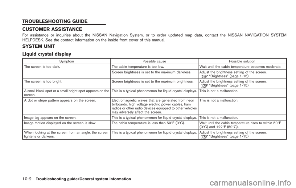
CUSTOMER ASSISTANCE
For assistance or inquiries about the NISSAN Navigation System, or to order updated map data, contact the NISSAN NAVIGATION SYSTEM
HELPDESK. See the contact information on the inside front cover of this manual.
SYSTEM UNIT
Liquid crystal display
SymptomPossible cause Possible solution
The screen is too dark. The cabin temperature is too low.Wait until the cabin temperature becomes moderate.
Screen brightness is set to the maximum darkness. Adjust the brightness setting of the screen.
“Brightness” (page 1-15)
The screen is too bright. Screen brightness is set to the maximum brightness. Adjust the brightness setting of the screen.
“Brightness” (page 1-15)
A small black spot or a small bright spot appears on the
screen. This is a typical phenomenon for liquid crystal displays. This is not a malfunction.
A dot or stripe pattern appears on the screen. Electromagnetic waves that are generated from neon billboards, high voltage electric power cables, ham
radios or other radio devices equipped to other vehicles
may adversely affect the screen.This is not a malfunction.
Image lag appears on the screen. This is a typical phenomenon for liquid crystal displays. This is not a malfunction.
Image motion displayed on the screen is slow. The cabin temperature is less than 508F(0 8C) . Wait until the cabin temperature rises to within 508F
(08C) and 1228F (508C) .
When looking at the screen from an angle, the screen
lightens or darkens. This is a typical phenomenon for liquid crystal displays. Adjust the brightness setting of the screen.
“Brightness” (page 1-15)
TROUBLESHOOTING GUIDE
Page 235 of 275
NAVIGATION
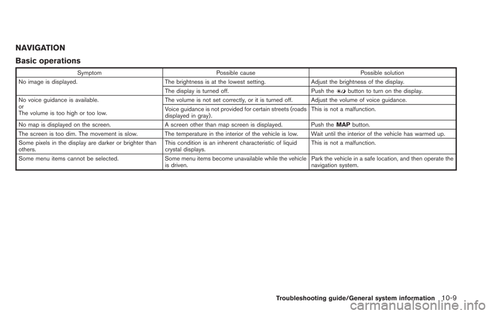
Basic operations
SymptomPossible cause Possible solution
No image is displayed. The brightness is at the lowest setting.Adjust the brightness of the display.
The display is turned off. Push the
button to turn on the display.
No voice guidance is available.
or
The volume is too high or too low. The volume is not set correctly, or it is turned off. Adjust the volume of voice guidance.
Voice guidance is not provided for certain streets (roads
displayed in gray).
This is not a malfunction.
No map is displayed on the screen. A screen other than map screen is displayed. Push the MAPbutton.
The screen is too dim. The movement is slow. The temperature in the interior of the vehicle is low. Wait until the interior of the vehicle has warmed up.
Some pixels in the display are darker or brighter than
others. This condition is an inherent characteristic of liquid
crystal displays.This is not a malfunction.
Some menu items cannot be selected. Some menu items become unavailable while the vehicle is driven.Park the vehicle in a safe location, and then operate the
navigation system.
Troubleshooting guide/General system information10-9
Page 236 of 275
10-10Troubleshooting guide/General system information
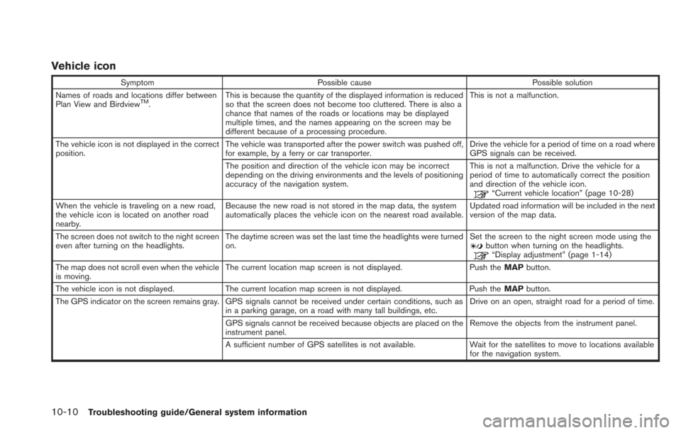
Vehicle icon
SymptomPossible cause Possible solution
Names of roads and locations differ between
Plan View and Birdview
TM. This is because the quantity of the displayed information is reduced
so that the screen does not become too cluttered. There is also a
chance that names of the roads or locations may be displayed
multiple times, and the names appearing on the screen may be
different because of a processing procedure. This is not a malfunction.
The vehicle icon is not displayed in the correct
position. The vehicle was transported after the power switch was pushed off,
for example, by a ferry or car transporter. Drive the vehicle for a period of time on a road where
GPS signals can be received.
The position and direction of the vehicle icon may be incorrect
depending on the driving environments and the levels of positioning
accuracy of the navigation system. This is not a malfunction. Drive the vehicle for a
period of time to automatically correct the position
and direction of the vehicle icon.
“Current vehicle location” (page 10-28)
When the vehicle is traveling on a new road,
the vehicle icon is located on another road
nearby. Because the new road is not stored in the map data, the system
automatically places the vehicle icon on the nearest road available.
Updated road information will be included in the next
version of the map data.
The screen does not switch to the night screen
even after turning on the headlights. The daytime screen was set the last time the headlights were turned
on. Set the screen to the night screen mode using the
button when turning on the headlights.“Display adjustment” (page 1-14)
The map does not scroll even when the vehicle
is moving. The current location map screen is not displayed.
Push theMAPbutton.
The vehicle icon is not displayed. The current location map screen is not displayed. Push the MAPbutton.
The GPS indicator on the screen remains gray. GPS signals cannot be received under certain conditions, such as in a parking garage, on a road with many tall buildings, etc. Drive on an open, straight road for a period of time.
GPS signals cannot be received because objects are placed on the
instrument panel. Remove the objects from the instrument panel.
A sufficient number of GPS satellites is not available. Wait for the satellites to move to locations available for the navigation system.
Page 241 of 275
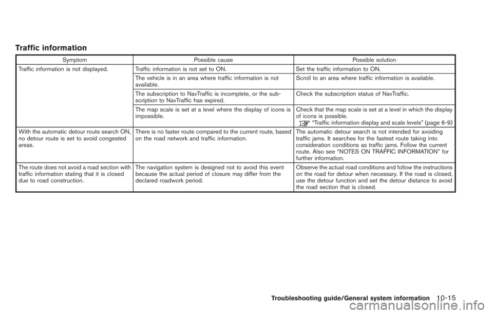
Traffic information
SymptomPossible cause Possible solution
Traffic information is not displayed. Traffic information is not set to ON. Set the traffic information to ON.
The vehicle is in an area where traffic information is not
available. Scroll to an area where traffic information is available.
The subscription to NavTraffic is incomplete, or the sub-
scription to NavTraffic has expired. Check the subscription status of NavTraffic.
The map scale is set at a level where the display of icons is
impossible. Check that the map scale is set at a level in which the display
of icons is possible.
“Traffic information display and scale levels” (page 6-9)
With the automatic detour route search ON,
no detour route is set to avoid congested
areas. There is no faster route compared to the current route, based
on the road network and traffic information.
The automatic detour search is not intended for avoiding
traffic jams. It searches for the fastest route taking into
consideration conditions as traffic jams. Follow the current
route. Also see “NOTES ON TRAFFIC INFORMATION” for
further information.
The route does not avoid a road section with
traffic information stating that it is closed
due to road construction. The navigation system is designed not to avoid this event
because the actual period of closure may differ from the
declared roadwork period. Observe the actual road conditions and follow the instructions
on the road for detour when necessary. If the road is closed,
use the detour function and set the detour distance to avoid
the road section that is closed.
Troubleshooting guide/General system information10-15
Page 250 of 275
10-24Troubleshooting guide/General system information
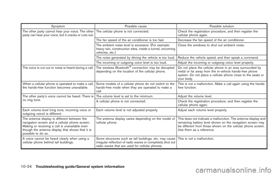
SymptomPossible cause Possible solution
The other party cannot hear your voice. The other
party can hear your voice, but it cracks or cuts out. The cellular phone is not connected.
Check the registration procedure, and then register the
cellular phone again.
The fan speed of the air conditioner is too fast. Decrease the fan speed of the air conditioner.
The ambient noise level is excessive. (For example:
heavy rain, construction sites, inside a tunnel, oncoming
vehicles, etc.) Close the windows to shut out ambient noise.
The noise generated by driving the vehicle is too loud. Reduce the vehicle speed, and then speak a command.
The incoming or outgoing voice level is too loud. Adjust the incoming or outgoing voice level properly.
The voice is cut out or noise is heard during a call. The wireless Bluetooth
®connection may be disrupted
depending on the location of the cellular phone. Do not place the cellular phone in an area surrounded by
metal or far away from the in-vehicle hands-free phone
system. Do not place a cellular phone close to the seats or
your body.
When a cellular phone is operated to make a call,
the hands-free function becomes unavailable. Some models of a cellular phone do not switch to the
hands-free mode when they are operated to make a
call. This is not a malfunction. Make a call again using the hands-
free function.
The other party’s voice cannot be heard. There is
no ring tone. The volume level is set to the minimum.
Adjust the volume level.
A cellular phone is not connected. Check the registration procedure, and then register the
cellular phone again.
Each volume level (ring tone, incoming voice or
outgoing voice) is different. Each volume level is not adjusted properly.
Adjust each volume level properly.
The antenna display is different between the
navigation screen and a cellular phone screen.
Making or receiving a call is unavailable even
though the antenna display that shows that it is
possible to do so. The antenna display varies depending on the model of
cellular phone.
This does not indicate a malfunction. The antenna display and
remaining battery level shown on the navigation screen may
be different from those shown on the cellular phone screen.
Use them as a reference.
A voice cannot be heard clearly when using a
cellular phone behind tall buildings. Some structures such as tall buildings, etc. may cause
irregular reflection of radio waves or completely shut out
radio waves that are used for cellular phones. This is not a malfunction.
Page 254 of 275
10-28Troubleshooting guide/General system information
CURRENT VEHICLE LOCATION
Display of current vehicle location
This navigation system combines the data
obtained from the vehicle (by gyro sensor) and
from GPS (Global Positioning System) satellites
to calculate the current location of the vehicle.
This position is then displayed throughout route
guidance to a destination.
What is GPS (Global Positioning
System)?
GPS is a position detecting system that uses
satellites deployed by the U.S. government. This
navigation system receives radio signals from
three or more different satellites that orbit
13,049 miles (21,000 km) above the earth in
space, and detects the position of the vehicle by
utilizing the principle of triangulation.
Positioning adjustment:
When the system judges that the vehicle
position is not accurate based on vehicle speed
and gyro sensor data calculations, the system
will automatically adjust the position of the
vehicle icon using GPS signals.
Receiving signals from GPS satellites:
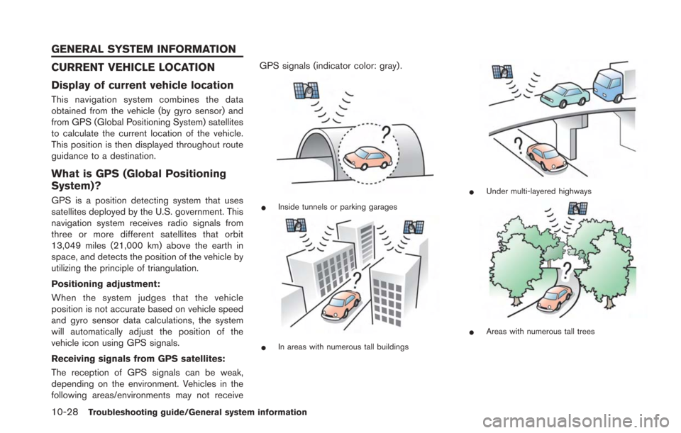
The reception of GPS signals can be weak,
depending on the environment. Vehicles in the
following areas/environments may not receiveGPS signals (indicator color: gray) .*Inside tunnels or parking garages
*In areas with numerous tall buildings
*Under multi-layered highways
*Areas with numerous tall trees
GENERAL SYSTEM INFORMATION
Page 257 of 275
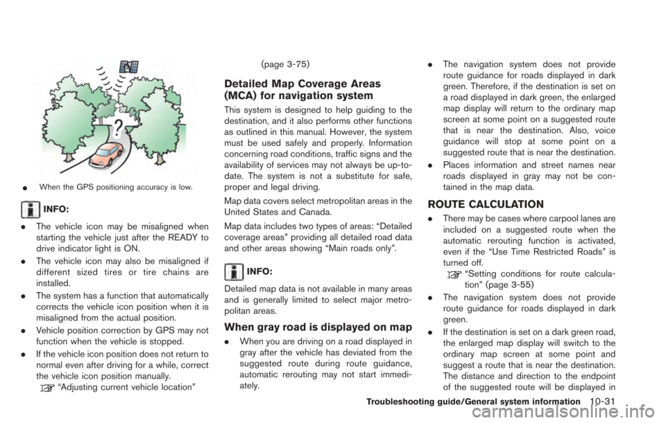
*When the GPS positioning accuracy is low.
INFO:
. The vehicle icon may be misaligned when
starting the vehicle just after the READY to
drive indicator light is ON.
. The vehicle icon may also be misaligned if
different sized tires or tire chains are
installed.
. The system has a function that automatically
corrects the vehicle icon position when it is
misaligned from the actual position.
. Vehicle position correction by GPS may not
function when the vehicle is stopped.
. If the vehicle icon position does not return to
normal even after driving for a while, correct
the vehicle icon position manually.
“Adjusting current vehicle location” (page 3-75)
Detailed Map Coverage Areas
(MCA) for navigation system
This system is designed to help guiding to the
destination, and it also performs other functions
as outlined in this manual. However, the system
must be used safely and properly. Information
concerning road conditions, traffic signs and the
availability of services may not always be up-to-
date. The system is not a substitute for safe,
proper and legal driving.
Map data covers select metropolitan areas in the
United States and Canada.
Map data includes two types of areas: “Detailed
coverage areas” providing all detailed road data
and other areas showing “Main roads only”.
INFO:
Detailed map data is not available in many areas
and is generally limited to select major metro-
politan areas.
When gray road is displayed on map
. When you are driving on a road displayed in
gray after the vehicle has deviated from the
suggested route during route guidance,
automatic rerouting may not start immedi-
ately. .
The navigation system does not provide
route guidance for roads displayed in dark
green. Therefore, if the destination is set on
a road displayed in dark green, the enlarged
map display will return to the ordinary map
screen at some point on a suggested route
that is near the destination. Also, voice
guidance will stop at some point on a
suggested route that is near the destination.
. Places information and street names near
roads displayed in gray may not be con-
tained in the map data.
ROUTE CALCULATION
.There may be cases where carpool lanes are
included on a suggested route when the
automatic rerouting function is activated,
even if the “Use Time Restricted Roads” is
turned off.
“Setting conditions for route calcula-
tion” (page 3-55)
. The navigation system does not provide
route guidance for roads displayed in dark
green.
. If the destination is set on a dark green road,
the enlarged map display will switch to the
ordinary map screen at some point and
suggest a route that is near the destination.
The distance and direction to the endpoint
of the suggested route will be displayed in
Troubleshooting guide/General system information10-31