2013 NISSAN GT-R change time
[x] Cancel search: change timePage 275 of 315
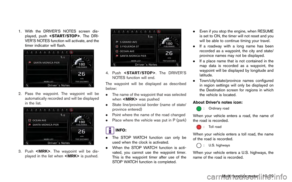
1. With the DRIVER’S NOTES screen dis-played, push
VER’S NOTES function will activate, and the
timer indicator will flash.
2. Pass the waypoint. The waypoint will be automatically recorded and will be displayed
in the list.
3. Push
played in the list when
4. Push
NOTES function will end.
The waypoint will be displayed as described
below:
. The name of the waypoint that was selected
when
. State line/provincial border (name of state/
province entered)
. Point where the name of the road changed
. Place where the vehicle was put in P (park)
INFO:
. The STOP WATCH function can only be
used when the clock is activated.
. When the STOP WATCH function is acti-
vated, you cannot use the waypoint timer.
This is the waypoint timer after use of the
STOP WATCH function is completed. .
Even if you stop the engine, when RESUME
is set to ON, the timer will not reset and you
will be able to continue timing your travel.
. If a roadway with a long name has been
recorded as a waypoint, the city and state/
province names may not be displayed.
. If a place name that is not contained in the
map data is recorded as a waypoint, the
waypoint will be displayed by longitude and
latitude.
. Town/city/state/province names configured
in region settings will only be displayed on
the Destination screen for regions in which
the vehicle is located.
About Driver’s notes icon:
: Ordinary road
When your vehicle enters a road, the name of
the road is recorded.
: Toll road
When your vehicle enters a toll road, the name
of the road is recorded.
: U.S. highways
When your vehicle enters a U.S. highways, the
name of the road is recorded.
Multi function meter10-29
Page 285 of 315
— If one section between waypoints cannotbe calculated, none of the route will be
displayed.
— The route may not connect completely at some waypoints.
— The route may require a U-turn close to some waypoints.
. Route calculation may not be completed in
the following cases.
— If there is no main road within a range of
1.5 miles (2.5 km) from the vehicle, a
message saying so will appear on the
screen. Try recalculating when the vehi-
cle is closer to a main road.
— If there is no main road within a range of 1.5 miles (2.5 km) from the destination or
waypoint, a message saying so will
appear on the screen. Try setting the
location closer to a main road.
— If the vehicle is too close to the destina- tion or if there are no roads to the
destination, a message saying so will
appear on the screen.
— If it is impossible to reach the destination or waypoints because of traffic regula-
tions, etc. — If the only route to reach the destination
or waypoints is extremely complicated.
— If the destination, current vehicle position or waypoint is within the “Avoid Area”.
— If a part of the route is included in the “Avoid Area”.
. The following may occur when the route is
displayed.
— If you calculate a route on a main road,
the starting point of the route may not
exactly match the current vehicle loca-
tion.
— The endpoint of the route may not exactly match the destination.
— If you calculate a route on a main road, the system may display a route from
another main road. This may be because
the position of the vehicle icon is not
accurate. In this case, park the vehicle in
a safe location and reset the vehicle icon,
or continue driving to see if the position
of the vehicle icon is automatically
adjusted before recalculating the route.
— There are cases in which the system shows an indirect route to reach the
destination or waypoints, if you set them
from stored or facility information. In
order to correct this, you must be careful
about the traffic direction, especially when lanes with different travel directions
are shown separately, such as inter-
changes and service areas.
— This system makes no distinction be- tween limited traffic control and total
control (blockage) . It may show an
indirect route even if the road is usable.
— Even if the freeway preference is set to OFF, a route that uses the freeway may
be suggested.
— Even if the ferry preference is set to OFF, a route that uses a ferry line may be
suggested.
— Ferry lines, excluding those that are only for pedestrians, bicycles and motor-
cycles, are stored in this system. Take
into consideration the travel time required
and operational condition before decid-
ing whether to use them or not.
General system information11-7
Page 289 of 315
.When approaching a waypoint, voice gui-
dance will announce, “You have arrived at
waypoint 1 (2, 3, 4,...) .” Voice guidance will
switch to the next section of the route. When
voice guidance is not available, refer to the
map for directions.
. In some cases, voice guidance ends before
arrival at the destination. Refer to the
destination icon on the map to reach the
destination.
. If the system recognizes on which side the
destination (waypoint) is located, voice
guidance will announce “on the right/left”
after announcing the arrival at the destina-
tion.
. Voice guidance may be partially operational
or inoperative due to the angle of roads at an
intersection.
. Because freeway lane information is avail-
able only for approximately 7,000 major
freeways in North America, it is not possible
to display information for all junctions and
exits.
. Freeway exit information may differ from the
information on the actual exit signs.
. Because it is not possible to consider data
concerning roads that are seasonally avail-
able or unavailable, a route may be displayed
that does not match the actual traffic restrictions. Be sure to follow the actual
traffic restrictions while driving.
. Canada and Alaska contain many roads with
incomplete map data. As a result, when
searching for a route, the route may include
roads with incomplete data. In regions
where road data is not complete, voice
guidance may stop for long periods of time.
Be sure to follow the actual traffic restric-
tions while driving..The XM NavTraffic®information service is
not provided for some cities. In addition, the
cities for which the traffic information service
is provided may be changed.
. In some cases, infrastructure problems may
prevent the complete display of the traffic
information. This is not a malfunction.
. Due to infrastructure problems, or due to the
time when the traffic information service
broadcast is received, the displayed infor-
mation may differ from the actual traffic
conditions.
. Depending on the traffic information, a
detour route may be slower than the original
route.
. XM NavTraffic
®is a service of XM®Satellite
Radio. XM NavTraffic®is only available in
select markets and is subject to data
availability. Reception of the XM
®signal
may vary depending on location. It requires a
monthly premium subscription. The service
provider is solely responsible for the quality
and accuracy of the information provided. All
fees and programming are subject to
change. For more details on the XM
NavTraffic
®service, terms and conditions,
please visit
www.xmradio.com.
You can also contact XM
®Radio at
General system information11-11
NOTES ON XM NavTraffic®
INFORMATION
Page 290 of 315
11-12General system information
1-800-XM-RADIO (1-800-967-2346) .
. As of January 31, 2009, the XM NavTraffic®
service covers 80 major metropolitan mar-
kets. For the most current list of markets
covered, please refer to
www.xmradio.com/navtraffic, or call XM
®
Radio customer support at 1-800-XM-
RADIO (1-800-967-2346) .
. Due to road maintenance, infrastructure
problems (e.g. malfunction of road sensors,
outage of central computer of infrastructure)
or natural disasters, there are times when
some or all traffic information may not be
available.
. Incident information is based on human
collection. Not all incidents that have hap-
pened are collected and provided.
. Due to infrastructure problems, or transmis-
sion delay, there are times when the
information may differ from the actual con-
dition. Always observe safe driving practices
and follow all traffic regulations.
. Due to the coverage and quality of traffic
information and road conditions, it is not
always possible for the system to provide
the shortest time route even when traffic
information is considered. .
Traffic information that is displayed may
differ from information from other media
(e.g., radio) , as other media may use
different information sources.
.The XM NavWeatherTMinformation service
is not provided for some cities. In addition,
the cities for which the weather information
service is provided may be changed.
. In some cases, infrastructure problems may
prevent the complete display of the weather
information. This is not a malfunction.
. Due to infrastructure problems, or due to the
time when the weather information service
broadcast is received, the displayed infor-
mation may differ from the actual weather
conditions.
. XM NavWeather
TMis a service of XM®
Satellite Radio. XM NavWeatherTMis only
available in select markets and is subject to
data availability. Reception of the XM
®signal
may vary depending on location. It requires a
monthly premium subscription. The service
provider is solely responsible for the quality
and accuracy of the information provided. All
fees and programming are subject to
change. For more details on the XM
NavWeather
TMservice, terms and condi-
tions, please visit www.xmradio.com. You
can also contact XM
®Radio at 1-800-XM-
RADIO (1-800-967-2346) .
. XM NavWeather
TMis designed to provide
real-time weather and forecasting informa-
tion in your general vicinity. Discrepancies
NOTES ON XM NAVWEATHERTM
INFORMATION
Page 291 of 315
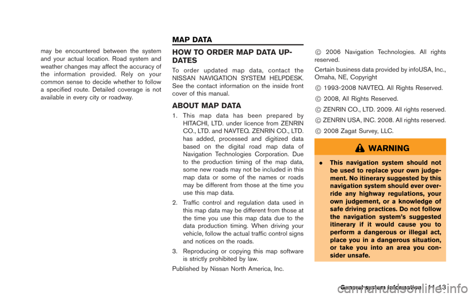
may be encountered between the system
and your actual location. Road system and
weather changes may affect the accuracy of
the information provided. Rely on your
common sense to decide whether to follow
a specified route. Detailed coverage is not
available in every city or roadway.HOW TO ORDER MAP DATA UP-
DATES
To order updated map data, contact the
NISSAN NAVIGATION SYSTEM HELPDESK.
See the contact information on the inside front
cover of this manual.
ABOUT MAP DATA
1. This map data has been prepared byHITACHI, LTD. under licence from ZENRIN
CO., LTD. and NAVTEQ. ZENRIN CO., LTD.
has added, processed and digitized data
based on the digital road map data of
Navigation Technologies Corporation. Due
to the production timing of the map data,
some new roads may not be included in this
map data or some of the names or roads
may be different from those at the time you
use this map data.
2. Traffic control and regulation data used in this map data may be different from those at
the time you use this map data due to the
data production timing. When driving your
vehicle, follow the actual traffic control signs
and notices on the roads.
3. Reproducing or copying this map software is strictly prohibited by law.
Published by Nissan North America, Inc.
*C2006 Navigation Technologies. All rights
reserved.
Certain business data provided by infoUSA, Inc.,
Omaha, NE, Copyright
*C1993-2008 NAVTEQ. All Rights Reserved.
*C2008, All Rights Reserved.
*CZENRIN CO., LTD. 2009. All rights reserved.
*CZENRIN USA, INC. 2008. All rights reserved.
*C2008 Zagat Survey, LLC.
WARNING
. This navigation system should not
be used to replace your own judge-
ment. No itinerary suggested by this
navigation system should ever over-
ride any highway regulations, your
own judgement, or a knowledge of
safe driving practices. Do not follow
the navigation system’s suggested
itinerary if it would cause you to
perform a dangerous or illegal act,
place you in a dangerous situation,
or take you into an area you con-
sider unsafe.
General system information11-13
MAP DATA
Page 309 of 315
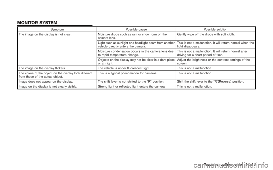
SymptomPossible cause Possible solution
The image on the display is not clear. Moisture drops such as rain or snow form on the
camera lens. Gently wipe off the drops with soft cloth.
Light such as sunlight or a headlight beam from another
vehicle directly enters the camera. This is not a malfunction. It will return normal when the
light disappears.
Moisture condensation occurs in the camera lens due
to rapid temperature change. This is not a malfunction. It will return normal after
driving for a short period of time.
Objects on the display may not be clear in a dark place
or at night. Adjust the brightness or the contrast settings of the
screen.
The image on the display flickers. The vehicle is under fluorescent light.This is not a malfunction.
The colors of the object on the display look different
from those of the actual object. This is a typical phenomenon for cameras.
This is not a malfunction.
Image does not appear on the display. The shift lever is not shifted to the "R" position. Shift the shift lever to the "R"(Reverse) position.
Image on the display is not clearly visible. Strong light or reflected light enters the camera. This is not a malfunction.
Troubleshooting guide12-13
MONITOR SYSTEM