2013 Acura TSX sat nav
[x] Cancel search: sat navPage 171 of 252

170Audio
Adjusting the SoundHAUDIO button
AUDIO MENU
Sound Setup
Adjust the sound bass, treble, fader, and ba
lance. You can also adjust the strength
of the sound coming from the center and
subwoofer speakers. In
addition, you can
set Dolby PL (ProLogic) II and Speed-s
ensitive Volume Compensation (SVC).
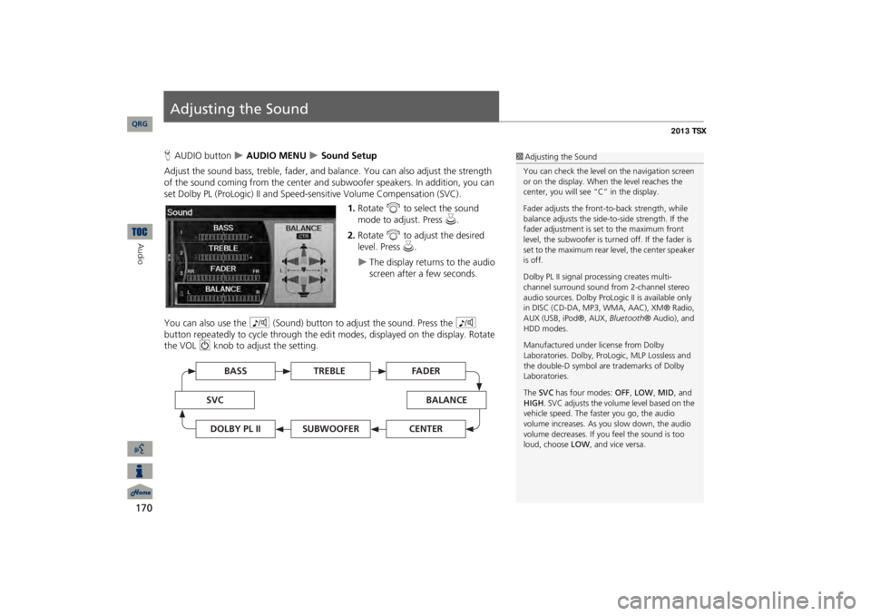
1.Rotate
i
to select the sound
mode to adjust. Press
u
.
2.Rotate
i
to adjust the desired
level. Press
u
.
The display returns to the audio screen after a few seconds.
You can also use the
8
(Sound) button to adjust the sound. Press the
8
button repeatedly to cycle through the edit
modes, displayed on the display. Rotate
the VOL
9
knob to adjust the setting.
1Adjusting the SoundYou can check the level on the navigation screen or on the display. When the level reaches the center, you will see “C” in the display. Fader adjusts the front-t
o-back strength, while
balance adjusts the side-to-side strength. If the fader adjustment is set to the maximum front level, the subwoofer is turned off. If the fader is set to the maximum rear level, the center speaker is off. Dolby PL II signal proc
essing creates multi-
channel surround sound fro
m 2-channel stereo
audio sources. Dolby ProL
ogic II is available only
in DISC (CD-DA, MP3, WMA, AAC), XM® Radio, AUX (USB, iPod®, AUX,
Bluetooth
® Audio), and
HDD modes. Manufactured under license from Dolby Laboratories. Dolby, ProL
ogic, MLP Lossless and
the double-D symbol are trademarks of Dolby Laboratories. The
SVC
has four modes:
OFF
, LOW
, MID
, and
HIGH
. SVC adjusts the volume level based on the
vehicle speed. The faster you go, the audio volume increases. As you slow down, the audio volume decreases. If you feel the sound is too loud, choose
LOW
, and vice versa.
TREBLE
BASS
SVC
BALANCE
FADER
SUBWOOFER
DOLBY PL II
CENTER
QRG
Page 213 of 252

212
Troubleshooting
Traffic
Troubleshooting
Traffic
Problem
Solution
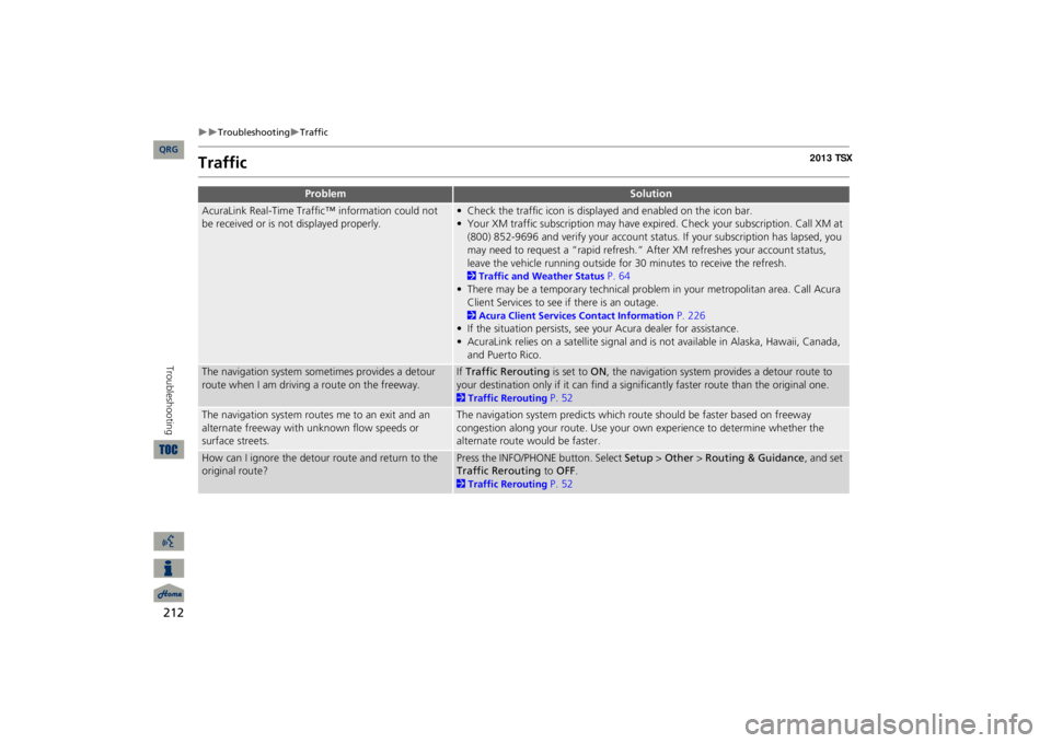
AcuraLink Real-Time Traffic™ information could not be received or is not displayed properly.
• Check the traffic icon is displayed and enabled on the icon bar.• Your XM traffic subscription may have expire
d. Check your subscription. Call XM at
(800) 852-9696 and verify your account status
. If your subscription has lapsed, you
may need to request a “rapid refresh.” After XM refreshes your account status, leave the vehicle running outside for
30 minutes to receive the refresh.
2Traffic and Weather Status
P. 64
• There may be a temporary technical problem in your metropolitan area. Call Acura Client Services to see if there is an outage. 2Acura Client Services Contact Information
P. 226
• If the situation persists, see your Acura dealer for assistance.• AcuraLink relies on a satellite signal and is not available in Alaska, Hawaii, Canada, and Puerto Rico.
The navigation system sometimes provides a detour route when I am drivi
ng a route on the freeway.
If Traffic Rerouting
is set to
ON
, the navigation system provides a detour route to
your destination only if it can find a signific
antly faster route than the original one.
2Traffic Rerouting
P. 52
The navigation system routes me to an exit and an alternate freeway with unknown flow speeds or surface streets.
The navigation system predicts which ro
ute should be faster based on freeway
congestion along your route. Use your own experience to determine whether the alternate route would be faster.
How can I ignore the detour route and return to the original route?
Press the INFO/PHONE button. Select
Setup
> Other
> Routing & Guidance
, and set
Traffic Rerouting
to
OFF
.
2Traffic Rerouting
P. 52
QRG
Page 215 of 252

214
Troubleshooting
Guidance, Routing
Troubleshooting
The vehicle position icon on the map “lags” a short distance behind, especially when I arrive at an intersection.
This is normal. The navigation system is unaware of the width of intersections. Large differences in vehicle position can indicate a temporary loss of the GPS signal. 2GPS System
P. 224
The screen is showing white dots as I drive along.
These dots are called “breadcrumbs.” These are displayed if
Off-road Tracking
is set
to ON
and you drive more than 1/2 mile off mapped roads.
2Off-road Tracking
P. 61
How do I remove the white dots (“breadcrumbs”) from my screen?
Press the INFO/PHONE button. Select
Setup
> Other
> Vehicle
, and set
Off-road
Tracking
to
OFF
, then return
to the map.
2Off-road Tracking
P. 61
A road that I selected to avoid is being used when routing.
When you “draw” your area to avoid, make
sure to select sections of roads that
include at least one intersection. 2Avoiding Streets
P. 122
My elevation (shown when I display the current position) seems to fluctuate even though my elevation has not changed.
This is normal. The elevation can vary
±100 feet due to GPS calculation errors.
2GPS System
P. 224
My elevation is missing on the “current position” screen.
The elevation is only displayed if the GPS antenna can receive signals from at least four satellites. Try moving the vehicle into an open area. The elevation is also not displayed if the calculated elevation is zero or below sea level.
Problem
Solution
QRG
Page 223 of 252

222Reference Information
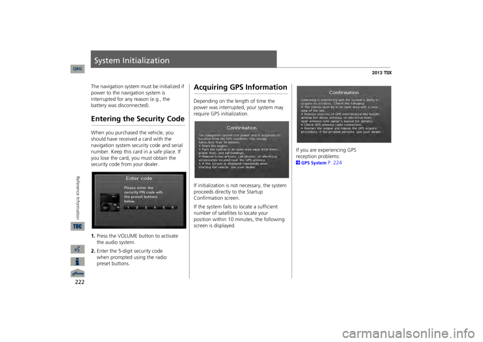
System InitializationThe navigation system must be initialized if power to the navigation system is interrupted for any reason (e.g., the battery was disconnected).Entering the Security CodeWhen you purchased the vehicle, you should have received a card with the navigation system security code and serial number. Keep this card in a safe place. If you lose the card, you must obtain the security code from your dealer. 1.Press the VOLUME button to activate the audio system.2.Enter the 5-digit security code
when
prompted using the radio
preset buttons.
Acquiring GPS InformationDepending on the length of time the power was interrupted, your system may require GPS initialization. If initialization is not necessary, the system proceeds directly to the Startup Confirmation screen. If the system fails to locate a sufficient number of satellites to locate your
position
within 10 minutes, the following
screen is displayed.
If you are experiencing GPS
reception problems:
2GPS System
P. 224
QRG
Page 225 of 252

224Reference Information
System LimitationsGPS SystemThe signals received from the GPS
satellites
are extremely weak (less than a
millionth of the strength of a local FM
station) and require an unobstructed view of sky. The GPS antenna is located in the dashboard.
The signal reception can
easily be
interrupted or interfered with by
the following:
•Metallic window tint on the front or side windows•Cell phones, PDAs, or other electronic devices docked in a cradle or lying loose on the dashboard•Remote starters or “hidden” vehicle tracking systems mounted near the navigation unit•Audio electronic devices mounted near the navigation unit•Trees, tall buildings, freeway overpasses, tunnels, or overhead electrical power wiresThe GPS is operated by the U.S. Department of Defense. For security reasons, there are certain inaccuracies built into the GPS for wh
ich the navigation
system must constantly compensate. This
can cause occasional positioning errors of up to several hundred feet.Address CalculationThe destination icon shows only the approximate location of a destination address. This occurs if the number of possible addresses is different from the number of actual addresses on a block. e.g., the address 1425 on a 1400 block with 100 possible addresses (because it is followed by the 1500 block) will be
shown
a quarter of the way down the
block by
the system. If there are only 25
actual addresses on the block, the actual
location of address 1425 would be at the end of the block.
DatabaseThe digitized map database reflects conditions as they existed at various points in time before production. Accordingly, your database may contain inaccurate or incomplete data or information due to the passage of time, road construction, changing conditions, or other causes. For example, some places/landmarks may be missing when you search the database because the name was misspelled, the place was improperly categorized, or a place/landmark is not yet in the database. This is also true for police stations, hospitals, and other public institutions.
Do
not rely on the navigation system if
you
need law enforcement or hospital
services.
Always check with local
information sources.
QRG
Page 229 of 252

228
Client Assistance
Traffic Information
Reference Information
Traffic InformationContinuously updated traffic information is available in major metropolitan areas across the 48 contiguous states and some cities in Canada. A list of coverage areas is available online. To find traffic information:1.Visit
www.acura.com/realtimetraffic
.
2.Select Real-Time Traffic on the TL.3.Click AcuraLink Real-Time Traffic.
Operation in Alaska, Hawaii, Canada, and Puerto RicoNavigation-equipped vehicles delivered to Alaska, Hawaii, Canada, and Puerto Rico are equipped with XM hardware, but XM broadcasting is not available. There are certain functions that rely on XM satellite signal coverage which are not available, including but not limited to AcuraLink and traffic/weather-related services. Unavailable menu options will appear gray on the LCD display. All roads displayed on the map screens are verified roads. Information in this manual relating to “unverified” roads or areas is not applicable.■XM® Radio■Map Coverage
Entering a destination address or place/landmark on another island may result in a screen caution message. This is because there are no ferry routes between islands in the database. If Street Name Guidance is set to ON, the street names will not be read out by
voice
guidance. This may change in a
future data
update.Shipping a Vehicle to
the U.S. Mainland
To receive XM audio, traffic, or weather information, you must
call XM and set up
an account at (800) 852-9696. To receive AcuraLink quick tips, contact Acura Client Services at (800) 382-2238, and ask them to activate your
AcuraLink unit.
■Address and Place Entry Screens■Puerto Rico
QRG
Page 230 of 252

229
Legal InformationCopyrights•infoUSA-Data: Certain business data provided by infoUSA, Inc., Omaha, NE, Copyright © 2011, All Rights Reserved.•EXIT-Data: © ZENRIN CO., LTD. 2011. All Rights Reserved.•Building foot print: © ZENRIN CO., LTD. 2011. All Rights Reserved.•Junction View Data: © ZENRIN USA, INC. 2011. All rights reserved.•ZAGAT SURVEY: © 2012 Zagat Survey, LLC. Zagat Survey is a registered trademark of Zagat Survey, LLC.•Brand icons: The icons for
companies
displayed by this product to
indicate
business locations are the
registered marks of their respective owners. The
use of such icons in this
product does
not imply any
sponsorship, approval, or endorsement by such companies of this
product.
User AgreementsIn using this HDD
“Satellite Linked
Navigation System” (the “HDD”), which includes HONDA MOTOR CO., LTD. software, ALPINE ELECTRONICS, INC. software, and NAVTEQ database contents (hereinafter referred to as “Licensors”), you are bound by the terms and conditions set forth below. By using your copy of the HDD, you have expre
ssed your Agreement
to the terms and conditions of this Agreement. You should, therefore, make sure that you read and understand the following provisions. If for any reason you do not wish to be bound by the terms of this Agreement, please return the HDD to your dealer. •The HDD may not be copied, duplicated, or otherwise modified, in whole or in part, without the express written permission of the Licensors.•The HDD may not be transferred or sublicensed to any third party for profit, rent or loan, or licensed for reuse in
any manner.
■Navigation System User Agreement
•The HDD may not be decompiled, reverse engineered or otherwise disassembled, in whole or in part.•The HDD may not be used in a network or by any other manner of simultaneous use in multiple systems.•The HDD is intended solely for
personal
use (or internal use where the
end-user is a business) by the consumer. The HDD is not to be used for
commercial purposes.
•The Licensors do not guarantee to
the client that the functions included in the HDD meet the specific objectives of the
user.•Licensor shall not be responsible for any damages caused by the use of the HDD to the actual user or
to any third party.
•The warranty on the HDD shall not extend to an exchange or refund due to misspelling, omission of letters, or any other cosmetic discrepancy in the contents of the HDD.•The right to use the HDD shall expire either when the user destroys the HDD or software, or when any of the terms of this Agreement are violated and the Licensors exercise the option to revoke the license to use the HDD or software.
Continued
QRG
Reference Information
Page 231 of 252

230
Legal Information
User Agreements
Reference Information
•The terms and conditions hereof apply to all subsequent users and owners as well as to the original purchaser.•The logos of oil companies, hotels, convenience stores, and other businesses are displayed for your information and convenience, and in no way imply any sponsorship, approval or endorsement of these companies, or their products. The logos are trademarks of their respective owners.The user shall indemnify and save harmless the Licensors, and their officers, employees and agents, from and against any claim, demand or action, irrespective of the nature of the cause of the claim, demand or action, alleging loss, costs, expense, damages or injuries (including injuries resulting in death) arising out of the use or possession of the HDD or software. Use, duplication, or di
sclosure of this HDD
by or on behalf of the United States government is subject to “Restricted Rights” as set forth at FAR 52.227-14, -19 or DFARS 252.227-7013, as applicable. Manufacturers are the Licensors, including HONDA MOTOR CO., LTD., 2-1-1 Minami Aoyama Minato-Ku Tokyo 107-8556 JAPAN., Alpine Electronics, Inc., 20-1
Yoshima Kogyodanchi, Iwaki,
Fukushima 970-1192 JAPAN., NAVTEQ Corporation,
425 W Randolph St.
Chicago, IL 60606,
USA. You have acquired a device (“DEVICE”) that includes software licensed by Alpine Electronics, Inc. (collectively “ALPINE”) from an affiliate of Microsoft Corporation (collectively “MS”). Those installed software products of MS origin, as well as associated media, printed materials, and “online” or electronic documentation (“SOFTWARE”) are protected by international intellectual property laws and treaties. The SOFTWARE is licensed, not sold. All righ
ts reserved.
IF YOU DO NOT AGREE TO THIS END USER LICENSE AGREEMENT (“EULA”), DO NOT USE THE DEVICE OR COPY THE SOFTWARE INSTEAD, PROMPTLY CONTACT ALPINE FOR INSTRUCTIONS ON RETURN OF THE UNUSED DEVICE(S) FOR A REFUND. ANY USE OF THE SOFTWARE, INCLUDING BUT NOT LIMITED TO USE ON THE DEVICE, WILL CONSTITUTE YOUR AGREEMENT TO ■Navigation System END USER LICENSE AGREEMENT
THIS EULA (OR RATIFICATION OF ANY PREVIOUS CONSENT). •GRANT OF SOFTWARE LICENSE This EULA grants
you the following
license: You may use the SOFTWARE only on the DEVICE.•NOT FAULT TOLERANT THE SOFTWARE IS NOT FAULT TOLERANT. ALPINE HAS INDEPENDENTLY DETERMINED HOW TO USE THE SOFTWARE IN THE DEVICE, AND MS HAS RELIED UPON ALPINE TO CONDUCT SUFFICIENT TESTING TO DETERMINE THAT THE SOFTWARE IS SUITABLE FOR SUCH USE.•NO WARRANTIES FOR THE SOFTWARE THE SOFTWARE is provided “AS IS” and with all faults. THE ENTIRE RISK AS TO SATISFACTORY QUALITY, PERFORMANCE, ACCURACY, AND EFFORT (INCLUDING LACK OF NEGLIGENCE) IS WITH YOU. ALSO, THERE IS NO WARRANTY AGAINST INTERFERENCE WTH YOUR ENJOYMENT OF THE SOFTWARE OR AGAINST INFRINGEMENT. IF YOU HAVE RECEIVED ANY WARRANTIES REGARDING THE DEVICE OR SOFTWARE THOSE
QRG