Page 37 of 407

37
1. BASIC INFORMATION BEFORE OPERATION
2
BASIC FUNCTION
ISF_IS_ISC_Navi_EE
5. MAP SCREEN OPERATION
The current position mark ( ) appears
in the centre or bottom centre of the
map screen.
A street name will appear on the bot-
tom of the screen, depending on the
scale of the map ( ).
CURRENT POSITION
DISPLAY
Press the “NAV” button, and touch
if the “Menu” screen is dis-
played, to display the current posi-
tion. This screen displays the current
position and a map of the surround-
ing area.
To correct the current position manu-
ally, see page 127.
INFORMATION
While driving, the current position
mark is fixed on the screen and the
map moves.
The current position is automatically
set as the vehicle receives signals
from the GPS (Global Positioning
System). If the current position is not
correct, it is automatically corrected
after the vehicle receives signals from
the GPS.
After battery disconnection, or on a
new vehicle, the current position may
not be correct. As soon as the system
receives signals from the GPS, the
correct current position is displayed.
Page 38 of 407

38
1. BASIC INFORMATION BEFORE OPERATION
ISF_IS_ISC_Navi_EE
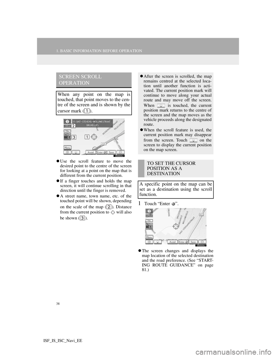
Use the scroll feature to move the
desired point to the centre of the screen
for looking at a point on the map that is
different from the current position.
If a finger touches and holds the map
screen, it will continue scrolling in that
direction until the finger is removed.
A street name, town name, etc. of the
touched point will be shown, depending
on the scale of the map ( ). Distance
from the current position to will also
be shown ( ).
1Touch “Enter ”.
The screen changes and displays the
map location of the selected destination
and the road preference. (See “START-
ING ROUTE GUIDANCE” on page
81.)
SCREEN SCROLL
OPERATION
When any point on the map is
touched, that point moves to the cen-
tre of the screen and is shown by the
cursor mark ( ).
After the screen is scrolled, the map
remains centred at the selected loca-
tion until another function is acti-
vated. The current position mark will
continue to move along your actual
route and may move off the screen.
When is touched, the current
position mark returns to the centre of
the screen and the map moves as the
vehicle proceeds along the designated
route.
When the scroll feature is used, the
current position mark may disappear
from the screen. Touch on the
screen to display the current position
on the map screen.
TO SET THE CURSOR
POSITION AS A
DESTINATION
A specific point on the map can be
set as a destination using the scroll
function.
Page 39 of 407

39
1. BASIC INFORMATION BEFORE OPERATION
2
BASIC FUNCTION
ISF_IS_ISC_Navi_EE
1Touch “Save”.
2This screen is displayed.
The registered point is shown by on
the map.
1Touch “Avoid”.
2Touch either or to change
the size of the area to be avoided.
3Touch “OK”.
TO REGISTER THE CURSOR
POSITION AS A MEMORY
POINT
Memory point registration enables
easy access to a specific point.
To change the icon or name, etc., see
“EDITING MEMORY POINTS” on
page 110.
INFORMATION
Up to 500 memory points can be reg-
istered. If there is an attempt to regis-
ter more than 500 memory points, an
error message will appear.
TO REGISTER THE CURSOR
LOCATION AS AN AREA TO
AVOID
A specific location on the map can be
set as an area to avoid using the scroll
function.
INFORMATION
If a destination is input in the area to
avoid or the route calculation cannot
be made without running through the
area to avoid, a route passing through
the area to be avoided may be shown.
Up to 10 locations can be registered
as areas to avoid. If there are 10 loca-
tions already registered, the following
message will be displayed: “Unable
to register additional points. Perform
the operation again after deleting 1 or
more points.”.
Page 40 of 407

40
1. BASIC INFORMATION BEFORE OPERATION
ISF_IS_ISC_Navi_EE
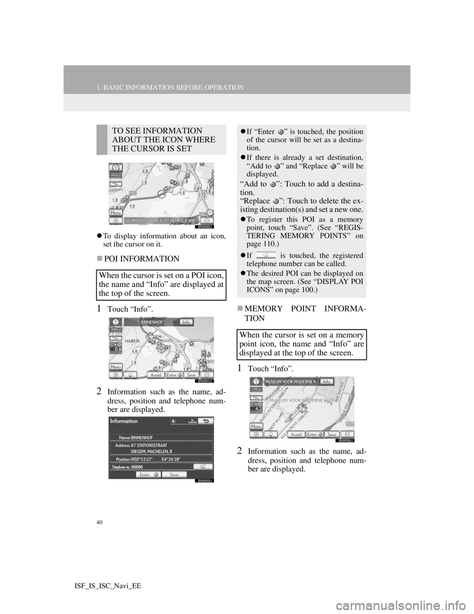
To display information about an icon,
set the cursor on it.
POI INFORMATION
1Touch “Info”.
2Information such as the name, ad-
dress, position and telephone num-
ber are displayed.
MEMORY POINT INFORMA-
TION
1Touch “Info”.
2Information such as the name, ad-
dress, position and telephone num-
ber are displayed.
TO SEE INFORMATION
ABOUT THE ICON WHERE
THE CURSOR IS SET
When the cursor is set on a POI icon,
the name and “Info” are displayed at
the top of the screen.If “Enter ” is touched, the position
of the cursor will be set as a destina-
tion.
If there is already a set destination,
“Add to ” and “Replace ” will be
displayed.
“Add to ”: Touch to add a destina-
tion.
“Replace ”: Touch to delete the ex-
isting destination(s) and set a new one.
To register this POI as a memory
point, touch “Save”. (See “REGIS-
TERING MEMORY POINTS” on
page 110.)
If is touched, the registered
telephone number can be called.
The desired POI can be displayed on
the map screen. (See “DISPLAY POI
ICONS” on page 100.)
When the cursor is set on a memory
point icon, the name and “Info” are
displayed at the top of the screen.
Page 41 of 407
41
1. BASIC INFORMATION BEFORE OPERATION
2
BASIC FUNCTION
ISF_IS_ISC_Navi_EE
If detailed memory point information
or images are registered in the naviga-
tion system, touch “Detail” to view the
information.
“Comment”: Touch to view detailed
memory point information.
“Image”: Touch to view memory point
images.
If “Enter ” is touched, the position
of the cursor will be set as a destina-
tion.
If there is already a set destination,
“Add to ” and “Replace ” will be
displayed.
“Add to ”: Touch to add a destina-
tion.
“Replace ”: Touch to delete the ex-
isting destination(s) and set a new one.
To edit a memory point, touch “Edit”.
(See “EDITING MEMORY
POINTS” on page 110.)
To delete a memory point, touch
“Delete”.
If is touched, the registered
telephone number can be called.
Page 42 of 407
42
1. BASIC INFORMATION BEFORE OPERATION
ISF_IS_ISC_Navi_EE
DESTINATION INFORMATION
1Touch “Info”.
2Information such as the name, ad-
dress, position and telephone num-
ber are displayed.
To delete a destination, touch “Delete”.
TRAFFIC INFORMATION
1Touch “Info”.
2Traffic information will be dis-
played on the screen.
To display detailed traffic event infor-
mation, touch “Details”.
When the cursor is set on a destina-
tion icon, the name and “Info” are
displayed on the top of the screen.
If is touched, the registered
telephone number can be called.
When the cursor is pointed to a traf-
fic information icon while a traffic
station is being received, the traffic
information and “Info” are dis-
played.
INFORMATION
Even when traffic information is not
currently being received, traffic infor-
mation and “Info” will be displayed
for a while after traffic information
has been received.
Page 43 of 407
43
1. BASIC INFORMATION BEFORE OPERATION
2
BASIC FUNCTION
ISF_IS_ISC_Navi_EE
1Press the “NAV” button, and touch
“Menu” if the map screen is dis-
played.
2Touch “Map configuration”.
3Touch the screen buttons to select
the desired configuration.
Depending on the conditions, certain
configuration screen buttons cannot be
selected.SWITCHING MAP
CONFIGURATIONS
Any of the screen configurations can
be selected.Screen buttonFunction
“Single map”
Touch to display the
single map screen.
(See page 44.)
“Dual map”Touch to display the
dual map screen. (See
page 44.)
“Compass”
Touch to display the
compass mode screen.
(See page 45.)
“Turn List”
Touch to display the
turn list screen. (See
page 86.)
“Arrow”Touch to display the
arrow screen. (See
page 87.)
“Intersection”
Touch to display the
intersection guidance
screen or the guidance
screen on the motor-
way. (See page 86.)
“Motorway”
Touch to display the
motorway informa-
tion. (See page 84.)
Page 44 of 407
44
1. BASIC INFORMATION BEFORE OPERATION
ISF_IS_ISC_Navi_EE
SINGLE MAP
The screen shows the single map.
DUAL MAP
This screen shows the dual map. The
map on the left is the main map.
EDITING RIGHT MAP
1Touch the desired screen button.
The following procedures can be per-
formed on this screen:
2Touch “OK” when editing is com-
pleted.
The screen returns to the dual map
screen.
SCREEN CONFIGURATIONS
This is a regular map screen.
While on a different screen, touching
“Single map” will display the single
map screen.
The map screen can be split into two.
While on a different screen, touching
“Dual map” will display the dual map
screen.
The right side map can be edited by
touching any point on the right side
map.
No.Function
Changing the orientation of the
map
Displaying POI icons
Showing traffic information (See
page 292.)
Changing the map scale