Page 89 of 194

destin
ations inthe destin ationmemor y.Itwill
be stor edther eperman ently. Stor
ingadesti nation permanent lyin
th edest inationmem ory
X Proc eedasdesc ribed inthe"Fr om thelist
of prev ious destinations"sec tion
(Y page 85). St
orin gth evehicle position inthelist
of previous destinations
X To switch onnav igat ionmod e:pres sth e
Ø function butt on.
X To show themen u:pres sW theCOMA ND
con troller .
X Sele ctPos iti on in
thenav igat ionsyst em
men ubar byturnin gcVd theCOMA ND
con troller andpres sW tocon firm.
X Sele ctSav e Veh
icle Pos
ition and
pres s
W tocon firm.
COMA NDstores thecur ren tveh icle
posit ionasadest inationinthelist of
prev ious destinations. St
orin gth ecross hairposit ioninthe
list ofprevious destinations
Rou teguid ance notactive Ac
rossha irapp ears onthe map ifyou have
moved themap manua lly.Y ou can store the
crosshair positionasadestinat ioninthe list
of previous destinations.
X To show themenu: pressWthe COMAND
cont roller.
X Select Position in
the navigation system
menu barbyturnin gcVd theCOMAND
cont roller andpress Wtoconf irm.
X Select SaveCrosshair Position and
press Wtoconf irm. Route
guidance isactive X
To show themenu: pressWthe COMAND
cont roller.
X Select Position in
the navigation system
menu barbyturnin gcVd theCOMAND
cont roller andpress Wtoconf irm.
X Select Destination PositionMap and
press Wtoconf irm.
You willsee themap withthecrosshair at
the destination .
X To show themenu: pressWthe COMAND
cont roller.
X Select Position in
the navigation system
menu barbyturnin gcVd theCOMAND
cont roller andpress Wtoconf irm.
X Select SaveCrosshair Position and
press Wtoconf irm.
COMAND storesthecrosshair positionas
a destination inthe listofprevious
destination s. Dele
ting oneofthe previous
destinat ions
X To switch onnavigation mode:pressthe
Ø functionbutton .
X To show themenu: pressWthe COMAND
cont roller.
X Select Destination in
the navigation
system menubarbyturnin gcVd the
COMAND controller andpress Wto
conf irm.
X Select FromLastDestinations and
press Wtoconf irm.
The listofprevious destination sappears.
X Select thedesired destination andpress
W toconf irm.
The destination addressappears.
X Select Delete and
press Wtoconf irm.
Ap rompt appears, asking whethe rthe
entr yshould bedeleted. Previous
destinations
87Navigationsystem Z
Page 90 of 194

X
Sel ect Yes or
No and
pressW toconfi rm.
If yo usel ect Yes ,
the entry isde leted.
If yo usel ect No ,
the process willbe aborte d. Map
operatio nand setting s Note
Co mpa nylogos displ ayed on the map are
trad ema rksofthe respective comp aniesand
us ed solelyfor the purpo seofind icating the
lo cati onofthes ecomp anies. The useof such
lo gos onthe map doesnot indicateappro val
of, supp ort ofor adverti sing bythes e
comp aniesfor the navi gation system itself. Se
tting themap scale
X To hide themen u:slide ZV theCOMAND
control lera nd, when the FullScr een menu
itemi sshown, pressW.
X To call upthe scale bar:assoon asyou
turn cVd theCOMAND controller, scale
bar =appea rs.
X Turn cVd untilthedesired scaleisset. :
Set map scale asanumber withunit
; Currently setmap scale asindicated by
the needle onthe scale bar
= Map scale
Unit ofmeasurement :inthe COMAND
displa ydepends onthe selection madeforthe
instrument cluster(seethevehicle
Operator's Manual). Moving
themap
Showin gthe crosshair X
To hide themenu: slideZVtheCOMAND
cont roller and,when theFull Screen menu
itemisshown, pressW.
X To scroll themap :slide XVY, ZVÆor
aVb theCOMAND controller.
Ac rossha irapp ears onthe map. Ifyou slide
it aga in,the map moves inthe
correspo ndingdirection under the
crossha ir. Map
withcrossha ir
: Current vehicl eposi tion
; Cross hair
= Detail sof the crossha irposi tion
? Map scale selected
Displ ay= may bethe name ofastreet, for
exampl e,provid edthe digitalmap contains
the necessary data.Itm ayalso showthegeo-
co ord inat eposi tiono fthe crosshair ifthe
Geo-coordinates displa
yis switched on
(Y page 91).
Hiding thecrosshair andcentering the
map onthe vehicle position or
destination X
Press thek backbutton twice.
The crosshair disappearsand themap is
set tothe vehicle position.
or
X Set themap tothe vehicle position; seethe
explanation below.88
Map
operat ionand settingsNavigat ionsystem
Page 91 of 194

Setting
themap tothe vehicle
position, destination orintermed iate
stop
Centering themap onthe vehicle
position X
To show themenu: pressWthe COMAND
cont roller.
X Select Position in
the navigation system
menu barbysliding VÆandturnin gcVd
the COMAND controller andpress Wto
conf irm.
X Select Vehicle Position Map and
press
W toconf irmor,ifthe crosshair isshown,
press thek backbutton.
This hides thecrosshair.
Centering onthe destination This
funct ionrequires thataroute toa
destination hasbeen calculated.
X To show themenu: pressWthe COMAND
cont roller.
X Select Position in
the navigation system
menu barbysliding VÆandturnin gcVd
the COMAND controller andpress Wto
conf irm.
X Select Destination PositionMap and
press Wtoconf irm.
The crosshair iscent ered onthe
destination.
Centering onanintermed iatestop
position This
funct ionrequires thataroute toa
destination hasbeen calculated.
X To show themenu: pressWthe COMAND
cont roller.
X Select Position in
the navigation system
menu barbysliding VÆandturnin gcVd
the COMAND controller andpress Wto
conf irm. X
Select Center MapOnStopover and
press Wtoconf irm.
The crosshair iscent ered onthe
interm ediate stopposition. Map
display
Setting themap orientation Map
orientation
: Current maporientation
The following displaymodesarepossible:
R 0 North orientation (themap view is
display edsothat northis alwa ysup).
R ¤ Orientat ionindirection oftravel (the
map isdisplay edsothat thedirection of
travel isalwa ysup; the orange pointofthe
icon points north).
R ¤ Bird's-eye view(themap isdisplay edso
that thedirection oftravel isalwa ysup; the
map project ionreproduces thecurvature
of the earth andtheorange pointofthe icon
points north).
R ¤ 3D map (themap isdisplay edsothat
the heading isalwa ysup; atascale of
1k mo rless, themap displays elevation
and terrainmodeling; theorange pointof
the icon point snort h) Map
opera tionandsettings
89Navigation system Z
Page 92 of 194

Exam
ple displ ay:B ird's- eyeview
: Curren tcrossha irposi tion
; Current maporientati on
X To show themenu: pressWthe COMAND
controller.
X Select Navi in
the main function barby
slid ing ZV andturning cVdtheCOMAND
controller andpress Wtoconfirm.
X Select MapOrientat ion and
press Wto
confirm.
A # dot indica testhe current setting. Map
orientati onmenu
X Select North Up ,
Heading Up ,
Bird's- eye
View or
3-D Map by
turning cVdthe
COMAND controller andpress Wto
confirm.
A # dot indica testhe new setting.
Setting thepoint ofintere stico nsinthe
map You
cansetthe points ofinterest youwishto
have displayed assymb olsonthe map. Points of
interest are,forexampl e,gas stations,
hotels, cinemas andrestau rants.
The followi ngsettings arepossi ble:
R Standard Symbols Symbol
displaydetermi nedbythe factory
settings.
R Personal Symbols You
candetermi nethe symb olsyou rself.
R No Symbols The
map does notshow anysymb ols.
X To show themenu: pressWthe COMAND
controller.
X Select Navi in
the main function barby
slid ing ZV andturning cVdtheCOMAND
controller andpress Wtoconfirm.
X Select POISymbols OnMap and
press
W toconfirm.
X Select Standard Symbols ,
Personal Symbols or
No Symbols .
If you selectPersonal Symbols ,
the listof
points ofinterest appears.
X To swi tch the icondisplay on/off:select
a point ofinterest byturning cVdthe
COMAND controller andpress Wto
confirm.
Dependi ngon the previ ousstate ofthe
symb ols,they willeither beshow nO or
hidd enª.Y oucan switch onthe symbol
display sfor more thanonepoint ofinter est.
i The listshows allsymbols thatare
cont ained onthe digital mapacross all
count ries.However, notallpoints of
interes tare ava ilable inall countries. Asa
resu lt,certain pointofinterest symbols
may notbedisp layed on the map, evenif
the symb oldisp layisswi tched on.
X To exitthe menu: pressthek back
button. 90
Map
operation andsetting sNavigatio nsystem
Page 93 of 194

Map
information inthe display
Show ingtext information During
routeguidance, youcan have map
informati ondisp layed atthe bottom edgeof
the disp lay.
X To show themenu: pressWthe COMAND
controller.
X Select Navi in
the mainfunction barby
sli ding ZVandturning cVdtheCOMAND
controller andpress Wtoconfirm.
X Select TextInforma tionOnMap and
press Wtoconfirm.
A # dot indica testhe current setting. X
Select Arrival Time/Distanc e ,
Current Street ,
Geo-coo rdinates or
None and
press Wtoconfirm.
X To exi tthe menu: slide XVY theCOMAND
controlle r.
Arrival time/di stancetothe destin ation Arrival
time/di stancedisplayswitched on
: Icon fordesti nation
; Distance tothe desti nation =
Icon forestima tedtime ofarri val
? Estimated timeofarri val
You canonly seethis displayduri ngroute
gui dance. Whilescroll ingthe map
(Y pag e61), youwillsee additiona ldata ,e.g.
road names, depending onthe crossha ir
posi tion, ifthe digital map supports thisdata .
i During routecalculation, orifthe vehi cle
is travel ingonanon-digi tizedroad,the
linea rdistanc eto the dest inationisshown .
In this case, thedisplay willbegrayed out.
Roa ddisp lay Road
display active
: Road namesor numb ers,e.g.for
highways
Geo-coor dinatedisp lay Geo-c
oordin atedisplay active
: Curren theight above average sealevel,
rounded
; Current vehicleposition :latit ude
co ord inat es
= Curr entv ehicle position :longitude
coordinat es
? Number ofGPS satellites currentlybeing
used
There mustbesufficient GPSreception forall
display sto be shown. Ifthis isnot thecase,
the display willbegrayed out.Height Map
operat ionand settings
91Navigation system Z
Page 94 of 194
,youwill
see thegeo-c oordinat esofthe cros shair
position")
display
:may varyfrom theactual value,
because thenavigat ionsystem usestheGPS
signals forthe calculation .
While scrolling themap (Ypage 61),youwill
see thegeo-c oordinat esofthe cros shair
position .Height display :and number of
satellites used?are not displayed.
"None" menuoption Display
switchedoff
: Current maporient ation
i Durin gthe "Move map"function youcan
see additional information depending on
the position ofthe cross hair,such asaroad
name, ifthe digital mapsupports thisdata. Switching
thetopogr aphical map on/
off
The topogr aphical mapuses differen tcolors
to depict elevation. Thecolor keygenerally
reflect sthe topography's dominant
vegetation orthe ground's perceived color
when seenfromtheair,forexample:
R green (grass) forlowland
R yellow ,brown (woodland) forhills
R gray (stone) andwhite (snow) for
mountains.
X To show themenu: pressWthe COMAND
cont roller.
X Select Navi in
the main functionbar by
sliding ZVandturnin gcVd theCOMAND
cont roller andpress Wtoconf irm. X
Select Topographic Map and
press Wto
conf irm.
Dependin gon the previous state,switch
the option onO oroff ª. Switching
thecity model on/off
When thecity model isswitched on,the map
shows buildingsas3D models.
i The citymodel isonly shown for"Bird's-
eye view" or"3D map".
It is availa bleinmap scales 1/32mi
(50 m)and 1/16 mi(100 m).
The data required fordisplay ingbuildi ngs
is not availa bleforallcities.
X To show themenu: pressWthe COMAND
cont roller.
X Select Navi in
the main functionbar by
sliding ZVandturnin gcVd theCOMAND
cont roller andpress Wtoconf irm.
X Select City (3D) and
press Wtoconf irm.
Dependin gon the previous state,switch
the option onO oroff ª. Example
display:citymodel Showing
themap dataversion
X To show themenu: pressWthe COMAND
cont roller.
X Select Navi in
the main functionbar by
sliding ZVandturnin gcVd theCOMAND
cont roller andpress Wtoconf irm. 92
Map
operat ionand settingsNavigation system
Page 95 of 194

X
Sel ect Map Version and
pressW to
confi rm.
The map data vers ionn umbe risshown.
Information aboutnew versions ofthe
digital mapcanbeobtained froman
authorized Mercedes-Benz Center. Tra
ffic informat iononthe map
If you subscribe tothe SIRIUS XMSatellite
Radi oTraffic Message Service,traffic
information canbedispla yedonthe map. You
can select threecategories forthe displa y.
X To switch thedisplays on/off:press W
the COMAND controller toshow themenu.
X Select Navi in
the main function barby
sliding ZVandturning cVdtheCOMAND
cont roller andpress Wtoconfirm.
X Select Traffic Information On Map and
press Wtoconfirm.
X Select acategory andpress Wtoconfirm.
Depending onthe previous state,switch
the option onO oroff ª. R
Tra ffic inciden ts
Road sections areillustrated withayell ow
line and arrows =.
R Speed &Flow
Road sections areillustr atedwithyellow or
red caricon s:.
Yellow caricon s:traffic jam, average speed
25 –45 mph
Red caricon s:traffic jam, average speed5
– 20 mph
R Free Flow
Road sections areillustr atedwithagreen
line and arrows ;. :
Speed &Flow
; FreeFlow
= Traff icinc ident s Add
itiona lsett ings Avoiding
anarea
Gener alinfor mation COMA
NDmak esitpossible toavoid areas
you donot wish todrive through.
The calculated routemay include anarea to
be avoided if:
R your destinationislocat edinsuch anarea.
R the rout euses roads thatlead through an
area tobe avoided.
i Highways withinblockedareas arealways
tak enintocon siderat ioninthe rout e
calc ulation . Add
itiona lsett ings
93Navigat ionsyst em Z
Page 96 of 194

X
To switcho nnavigat ionmode: pressthe
Ø function button .
X To show themenu: pressWthe COMAND
con troller.
X Select Navi in
the main function barby
sliding ZVandturningcVd theCOMAND
con troller andpress Wtocon firm.
X Select Block Area and
press Wto
con firm.
If you have notyetsetany area tobe
avoided, youwillsee themap withthe
cross hair(option 1).
If you have previously setone ormore areas
to be avoided, youwillsee alist (option 2).
Opt ion 1:the map X
To scroll themap :slide theCOMAND
con troller XVY,ZVÆoraVb.
X To set the map scale: assoon asyou turn
cVd theCOMAND controller, thescale bar
appears. Turningclockwisezooms outfrom
the map, turningcount er-clockwise zooms
in.
X Turn cVd untilthedesired scaleisset.
X To app lyablock: pressWthe COMAND
con troller.
Ar ed square appears onthe map. X
To adj ust the size ofthe squa re:turn
cVd theCOMAND controller.
The square isenlarged orreduced. X
To confirm thesettings: pressW.
The listappears. Thepreviously selected
area tobe avoided hasbeen added and
activ ated.
X Follow theinst ruct ions listed under "Option
2: the list".
Opt ion 2:the listappears X
Select Avoid NewArea by
turn ingcVd
the COMAND controller andpress Wto
con firm.
The map withthecross hairappears.
X Proceed asdescribed under"Option 1:the
map" ifyou wish toset anew area tobe
avoided.
Switching anavoided areaon/off X
Select anent ryinthe listbyturn ingcVd
the COMAND controller andpress Wto
con firm.
The avoided areaisswitch edon O oroff
ª, depending onthe previous status.
Displaying andchanging anavoided
area X
Select anent ryinthe listbyturn ingcVd
the COMAND controller.
X Select Options by
sliding VYthe
COMAND controller andpress Wto
con firm. 94
Addit
ional settingsNavigation system
 1
1 2
2 3
3 4
4 5
5 6
6 7
7 8
8 9
9 10
10 11
11 12
12 13
13 14
14 15
15 16
16 17
17 18
18 19
19 20
20 21
21 22
22 23
23 24
24 25
25 26
26 27
27 28
28 29
29 30
30 31
31 32
32 33
33 34
34 35
35 36
36 37
37 38
38 39
39 40
40 41
41 42
42 43
43 44
44 45
45 46
46 47
47 48
48 49
49 50
50 51
51 52
52 53
53 54
54 55
55 56
56 57
57 58
58 59
59 60
60 61
61 62
62 63
63 64
64 65
65 66
66 67
67 68
68 69
69 70
70 71
71 72
72 73
73 74
74 75
75 76
76 77
77 78
78 79
79 80
80 81
81 82
82 83
83 84
84 85
85 86
86 87
87 88
88 89
89 90
90 91
91 92
92 93
93 94
94 95
95 96
96 97
97 98
98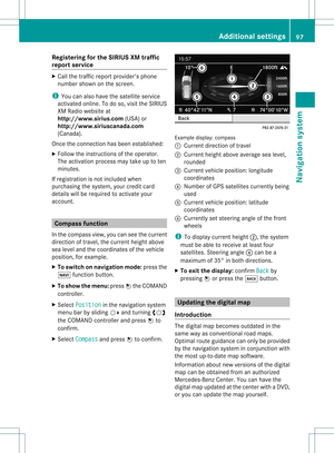 99
99 100
100 101
101 102
102 103
103 104
104 105
105 106
106 107
107 108
108 109
109 110
110 111
111 112
112 113
113 114
114 115
115 116
116 117
117 118
118 119
119 120
120 121
121 122
122 123
123 124
124 125
125 126
126 127
127 128
128 129
129 130
130 131
131 132
132 133
133 134
134 135
135 136
136 137
137 138
138 139
139 140
140 141
141 142
142 143
143 144
144 145
145 146
146 147
147 148
148 149
149 150
150 151
151 152
152 153
153 154
154 155
155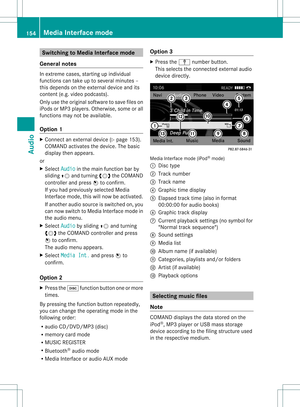 156
156 157
157 158
158 159
159 160
160 161
161 162
162 163
163 164
164 165
165 166
166 167
167 168
168 169
169 170
170 171
171 172
172 173
173 174
174 175
175 176
176 177
177 178
178 179
179 180
180 181
181 182
182 183
183 184
184 185
185 186
186 187
187 188
188 189
189 190
190 191
191 192
192 193
193