Page 93 of 194

Map
information inthe display
Show ingtext information During
routeguidance, youcan have map
informati ondisp layed atthe bottom edgeof
the disp lay.
X To show themenu: pressWthe COMAND
controller.
X Select Navi in
the mainfunction barby
sli ding ZVandturning cVdtheCOMAND
controller andpress Wtoconfirm.
X Select TextInforma tionOnMap and
press Wtoconfirm.
A # dot indica testhe current setting. X
Select Arrival Time/Distanc e ,
Current Street ,
Geo-coo rdinates or
None and
press Wtoconfirm.
X To exi tthe menu: slide XVY theCOMAND
controlle r.
Arrival time/di stancetothe destin ation Arrival
time/di stancedisplayswitched on
: Icon fordesti nation
; Distance tothe desti nation =
Icon forestima tedtime ofarri val
? Estimated timeofarri val
You canonly seethis displayduri ngroute
gui dance. Whilescroll ingthe map
(Y pag e61), youwillsee additiona ldata ,e.g.
road names, depending onthe crossha ir
posi tion, ifthe digital map supports thisdata .
i During routecalculation, orifthe vehi cle
is travel ingonanon-digi tizedroad,the
linea rdistanc eto the dest inationisshown .
In this case, thedisplay willbegrayed out.
Roa ddisp lay Road
display active
: Road namesor numb ers,e.g.for
highways
Geo-coor dinatedisp lay Geo-c
oordin atedisplay active
: Curren theight above average sealevel,
rounded
; Current vehicleposition :latit ude
co ord inat es
= Curr entv ehicle position :longitude
coordinat es
? Number ofGPS satellites currentlybeing
used
There mustbesufficient GPSreception forall
display sto be shown. Ifthis isnot thecase,
the display willbegrayed out.Height Map
operat ionand settings
91Navigation system Z
Page 94 of 194

display
:may varyfrom theactual value,
because thenavigat ionsystem usestheGPS
signals forthe calculation .
While scrolling themap (Ypage 61),youwill
see thegeo-c oordinat esofthe cros shair
position .Height display :and number of
satellites used?are not displayed.
"None" menuoption Display
switchedoff
: Current maporient ation
i Durin gthe "Move map"function youcan
see additional information depending on
the position ofthe cross hair,such asaroad
name, ifthe digital mapsupports thisdata. Switching
thetopogr aphical map on/
off
The topogr aphical mapuses differen tcolors
to depict elevation. Thecolor keygenerally
reflect sthe topography's dominant
vegetation orthe ground's perceived color
when seenfromtheair,forexample:
R green (grass) forlowland
R yellow ,brown (woodland) forhills
R gray (stone) andwhite (snow) for
mountains.
X To show themenu: pressWthe COMAND
cont roller.
X Select Navi in
the main functionbar by
sliding ZVandturnin gcVd theCOMAND
cont roller andpress Wtoconf irm. X
Select Topographic Map and
press Wto
conf irm.
Dependin gon the previous state,switch
the option onO oroff ª. Switching
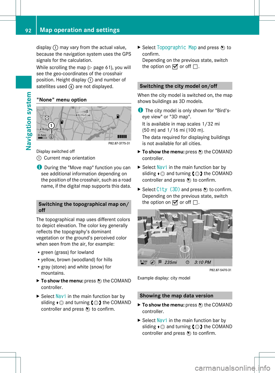
thecity model on/off
When thecity model isswitched on,the map
shows buildingsas3D models.
i The citymodel isonly shown for"Bird's-
eye view" or"3D map".
It is availa bleinmap scales 1/32mi
(50 m)and 1/16 mi(100 m).
The data required fordisplay ingbuildi ngs
is not availa bleforallcities.
X To show themenu: pressWthe COMAND
cont roller.
X Select Navi in
the main functionbar by
sliding ZVandturnin gcVd theCOMAND
cont roller andpress Wtoconf irm.
X Select City (3D) and
press Wtoconf irm.
Dependin gon the previous state,switch
the option onO oroff ª. Example
display:citymodel Showing
themap dataversion
X To show themenu: pressWthe COMAND
cont roller.
X Select Navi in
the main functionbar by
sliding ZVandturnin gcVd theCOMAND
cont roller andpress Wtoconf irm. 92
Map
operat ionand settingsNavigation system
Page 99 of 194

Reg
isteri ngfor the SIRIU SXM traffic
repo rtse rvic e X
Ca llthe traff icrep ort provider'spho ne
numb ersho wnonthe scre en.
i Youcan also have the satell ite service
acti vate donli ne. Todo so, visitthe SIRIUS
XM Radio we bsi teat
http:// www.sirius.c om(USA) or
http:// www.siriusc anada.c om
(C ana da).
Once theconnecti onhasbee nestablished:
X Follow theinstruct ionsofthe operator.
The activation processmaytake uptoten
minutes.
If registration isnot included when
purchasing thesystem, yourcredit card
details willberequired toactivate your
account. Compass
function
In the compass view,youcan seethecurrent
direction oftravel, thecurrent heightabove
sea level andthecoordinates ofthe vehicle
position, forexample.
X To switch onnavigation mode:pressthe
Ø function button.
X To show themenu: pressWthe COMAND
cont roller.
X Select Position in
the navigation system
menu barbysliding VÆandturning cVd
the COMAND controller andpress Wto
confirm.
X Select Compass and
press Wtoconfirm. Example
display:compass
: Current direction oftravel
; Current heightaboveaverage sealevel,
rounded
= Current vehicleposition: longitude
coordinates
? Number ofGPS satellites currentlybeing
used
A Current vehicleposition: latitude
coordinates
B Currently setsteering angleofthe front
wheels
i Todispla ycurrent height;,thesystem
must beable toreceive atleast four
satellites. SteeringangleBcan bea
maximum of35° inboth directions.
X To exit thedisplay: confirmBack by
pressing Worpress thek button. Updat
ingthe digital map
Introduction The
digital mapbecomes outdatedinthe
same wayasconven tionalroadmaps.
Optimal routeguidancecanonly beprovided
by the navigation systeminconj unction with
the most up-to-date mapsoftware.
Information aboutnew version sof the digital
map canbeobtained fromanauthoriz ed
Mercedes- BenzCenter .You canhave the
digital mapupdated atthe centerwith aDVD ,
or you can update themap yourself. Addit
ional settings
97Navigation system Z