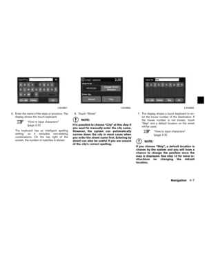
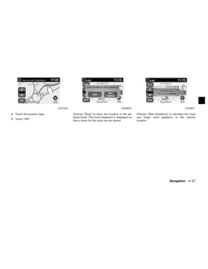
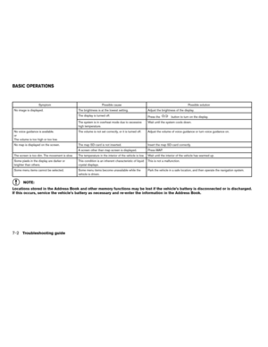
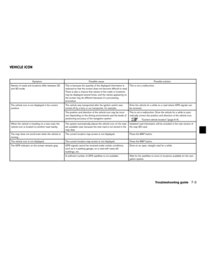
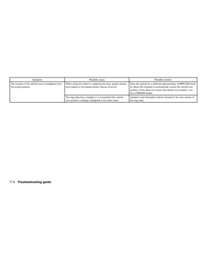
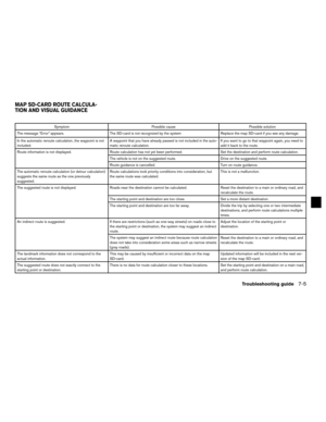
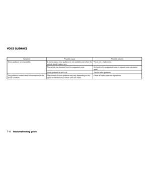
Page 17 of 79

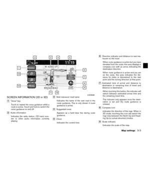
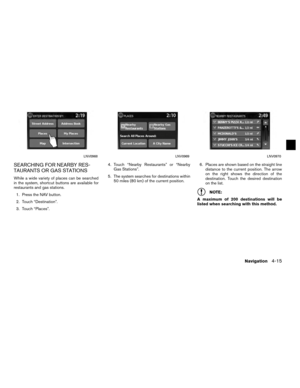
�10Vehicle iconIndicates the current location and direction
of the vehicle.
�11Current road indicatorThe location of where the car is positioned.
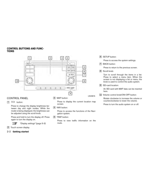
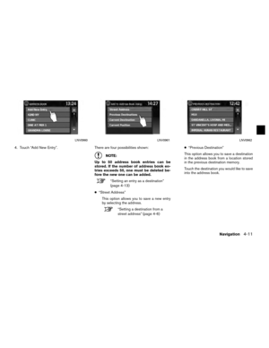
�12“Menu” keyWhen touching this key, the items “Store
Current Position”, “Show Position/GPS
Information”, “Show Destination Informa-
tion” or “Map Setup” can be selected.
“Map options menu screen”
(page 3-5)
�13Zoom in and zoom out keysUse to zoom the map in or out. To scroll the map in either direction:
1. Touch and release the screen anywhere on the map.
2. Touch the screen again and move your fin- ger along the screen in the direction you
wish to scroll.
After releasing and touching the map again, a
marker will be displayed at the point touched
and, if possible, the position determined.
NOTE:
● If the map is in 3D view, touching the map to
scroll will automatically switch the map to the
2D view and will automatically orientate the
map North Up.
● If the map is in 2D view, the map will be ori-
ented North Up. ●
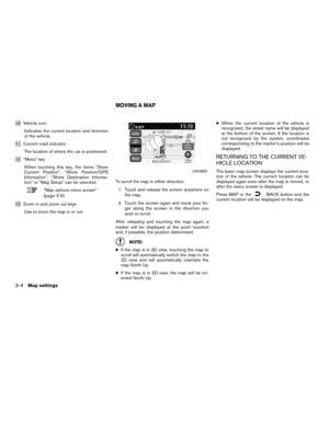
When the current location of the vehicle is
recognized, the street name will be displayed
at the bottom of the screen. If the location is
not recognized by the system, coordinates
corresponding to the marker’s position will be
displayed.
RETURNING TO THE CURRENT VE-
HICLE LOCATION
The basic map screen displays the current loca-
tion of the vehicle. The current location can be
displayed again even after the map is moved, or
after the menu screen is displayed.
Press MAP or the
BACK button and the
current location will be displayed on the map.
LNV0937
MOVING A MAP
3-4Map settings
Page 18 of 79
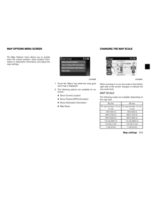
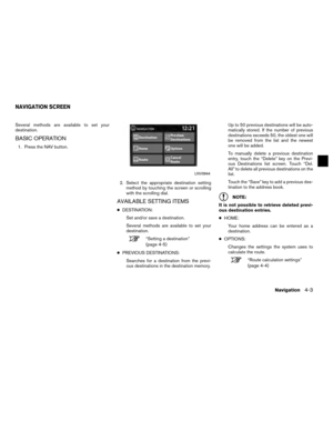
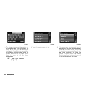
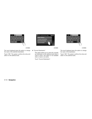
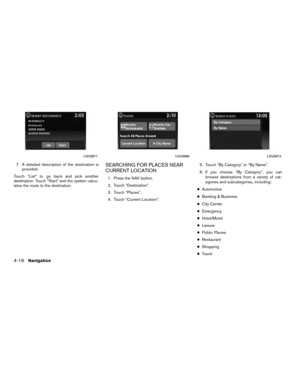
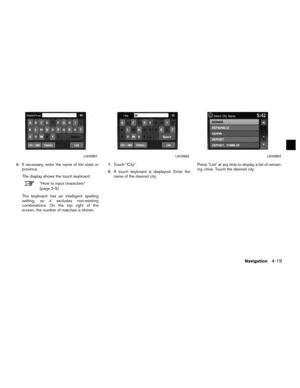
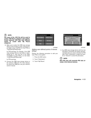
The Map Options menu allows you to quickly
store the current position, show position infor-
mation or destination information, and adjust the
map settings.1. Touch the “Menu” key while the route guid-ance map is displayed.
2. The following options are available for se- lection:
● Store Current Location
● Show Position/GPS Information
● Show Destination Information
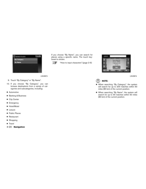
● Map Setup When zooming in or out, the scale on the bottom
right side of the screen changes to indicate the
new scale level.
MAP SCALE
The following scales are available depending on
the map view:
2D view
3D view
Per approximately 1/2 inch (1 cm) Per approximately 1/2 inch
(1 cm)
150 ft (50 m) 150 ft (50 m)
300 ft (100 m) 300 ft (100 m)
600 ft (200 m) 600 ft (200 m)
1/4 mile (500 m) 1/4 mile (500 m)
1/2 mile (1 km) 1/2 mile (1 km)
1 mile (2 km) 1 mile (2 km)
LNV0938LNV0939
MAP OPTIONS MENU SCREEN CHANGING THE MAP SCALE
Map settings3-5
Page 19 of 79
2D view3D view
2.5 mi (5 km) —
5 mi (10 km) —
10 mi (20 km) —
25 mi (50 km) —
50 mi (100 km) —
100 mi (200 km) —
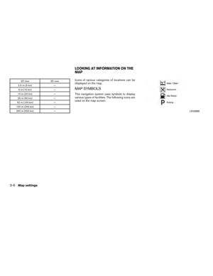
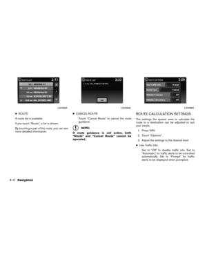
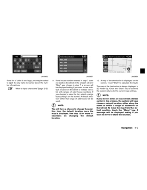
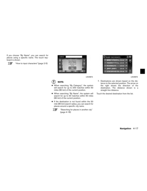
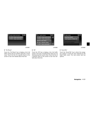
250 mi (500 km) —Icons of various categories of locations can be
displayed on the map.
MAP SYMBOLS
This navigation system uses symbols to display
various types of facilities. The following icons are
used on the map screen:
LNV0998
LOOKING AT INFORMATION ON THE
MAP
3-6Map settings
Page 20 of 79
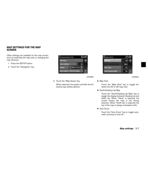
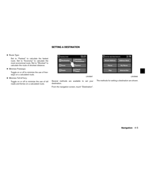
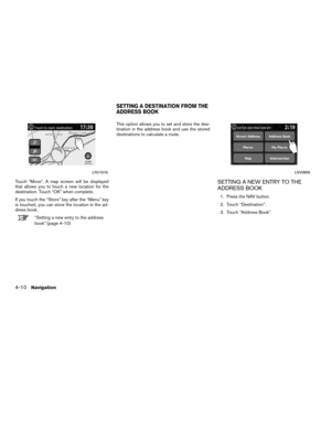
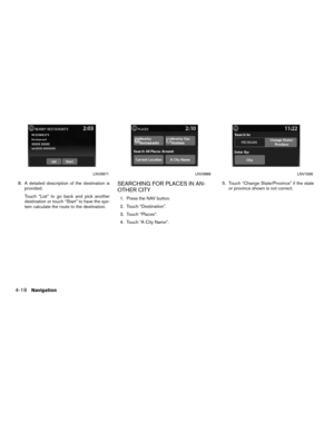
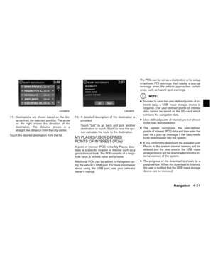
Other settings are available for the map screen,
such as switching the map view or changing the
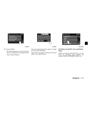
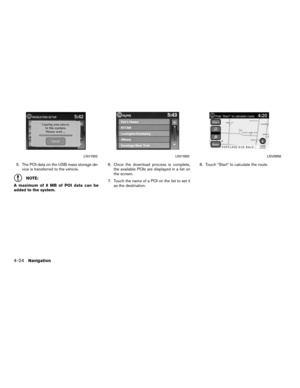
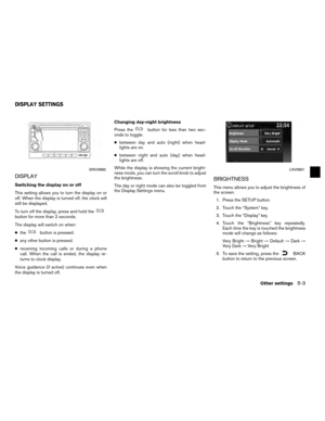
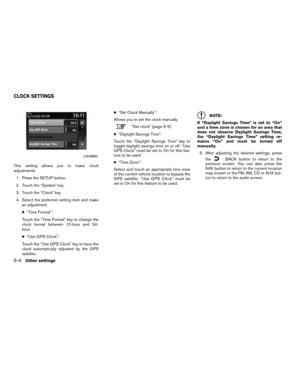
map direction.1. Press the SETUP button.
2. Touch the “Navigation” key.
3. Touch the “Map Setup” key.When selected, the system will offer the fol-
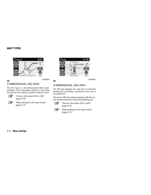
lowing map setting options: ●
Map View
Touch the “Map View” key to toggle be-
tween the 2D or 3D map view.
● North/Heading Up Map
Touch the “North/Heading Up Map” key to
toggle the display between Heading Up and
North Up. When “Head” is selected, the
screen shows the map in the driving
direction. When “North Up” is selected, the
top of the map is always orientated north.
● Auto Zoom
Touch the “Auto Zoom” key to toggle auto-
matic zooming on and off.
LNV0940LNV0942
MAP SETTINGS FOR THE MAP
SCREEN
Map settings3-7
Page 21 of 79

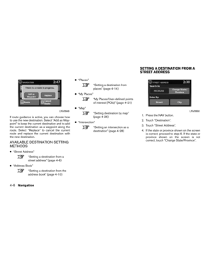
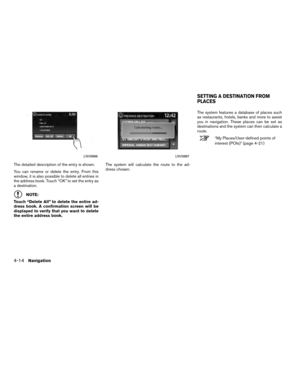
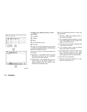
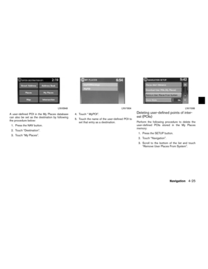
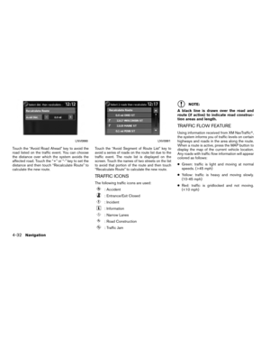
●Show Places on Map
Touch the “Show Places on Map” key to ac-
tivate or deactivate the display of place
icons on the map. When the icon on the
map is touched, place information will be
displayed.
● Show Incidents
Touch the “Show Incidents” key to enable
traffic incident information on the map
screen.
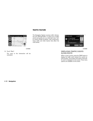
“Traffic Feature” (page 4-30)
● Show Traffic Flow
Touch the “Show Traffic Flow” key to enable
traffic flow information on the map screen.
“Traffic Flow Feature”
(page 4-32)
● Map Data Information
Touch the “Map Data Information” key and
the follow-up screen will display the version
of the current installed map.
“Map SD-card” (page 3-8) The SD-card slot is located on the front of the
unit. When you purchase this system, an SD-
card with map data is provided.
NOTE:
● Before inserting the map SD-card confirm
that there is no SD-card already in the slot.
● The SD-card slot can only read the SD-card
with map data provided specifically for use
with the vehicle’s navigation system. The sys-
tem will not read other SD-cards.
HOW TO HANDLE THE SD-CARD
When handling the SD-card, please be careful
and adhere to the following instructions:
CAUTION
● Handle the SD-card with care. Never
touch the metal contacts.
● Do not use any conventional cleaner,
benzine, thinner, or antistatic spray.
● If you need to clean the SD-card use
a soft cloth.
● Never attempt to use an SD-card that
has been cracked, deformed or re-
paired using adhesive. Doing so may
damage the equipment.
● Do not try to bend the SD-card. Do
not use any SD-card that is bent or
cracked.
● Do not put on any sticker or write
anything on either surface.
● Handle the SD-card carefully to
avoid contamination or flaws.
Otherwise, the data may not be read
properly.
LNV0941
MAP SD-CARD
3-8Map settings
Page 22 of 79

●Do not store the SD-card in locations
exposed to direct sunlight, or in high
temperatures or humidity.
● Always place the SD-card in its stor-
age case when not in use.
SD-CARD REPLACEMENT
For additional SD-cards with map data, contact
the Nissan Navigation Helpdesk.
HOW TO ORDER MAP DATA UP-
DATES
To order updated map data, contact the Nissan
Navigation Helpdesk.
ABOUT THE MAP DATA
● Bosch has compiled the digitized map data
into a usable format. © 2009 Robert Bosch
GmbH all rights in compilation software
reserved. Due to the production timing of the
map data, some new roads may not be
included, or some names and roads may be
different from those in use at the time this map
data is used. ●
Traffic control and regulation data used in this
map data may be different from those in use at
the time this map data is used. When driving,
follow the actual traffic control signs and no-
tices on the roads.
● Reproducing or copying this map software is
strictly prohibited by law.
�WARNING
● This navigation system should not be
used to replace your own judgement.
No itinerary suggested by this navi-
gation system should ever override
any freeway regulations, your own
judgement, or a knowledge of safe
driving practices. Do not follow the
navigation system’s suggested itin-
erary if it would cause you to perform
a dangerous or illegal act, place you
in a dangerous situation, or take you
into an area you consider unsafe. ●
The advice provided by the naviga-
tion system is to be regarded as a
suggestion only. There may be times
when the navigation system displays
the vehicle’s location incorrectly,
fails to suggest the shortest route, or
fails to direct you to your desired
destination. In such instances, rely
on your own judgement taking into
account the driving conditions at the
time.
● Do not use the navigation system to
locate emergency services. The data-
base does not contain a complete
listing of emergency services such as
police stations, fire stations, hospi-
tals and walk-in clinics. Please show
discretion and ask for directions in
such instances.
● As the driver, you alone are respon-
sible for your driving safety.
– In order to avoid a traffic accident, do not operate the system while
driving.
Map settings
3-9
Page 23 of 79

– In order to avoid a traffic accident,operate the system only when the
vehicle is stopped at a safe place
and the parking brake is on.
– In order to avoid a traffic accident or traffic offence, remember that
actual road conditions and traffic
regulations take precedence over
the information contained on the
navigation system.
– The software may contain inaccu- rate or incomplete information
due to the passage of time,
changing circumstances, and the
sources of information used.
Please respect current traffic con-
ditions and regulations at all
times while driving.
– Where actual road conditions and highway regulations differ from
the information contained on the
navigation system, abide by the
highway regulations.
– Keep the amount of time spent viewing the screen while driving
to a strict minimum.The navigation system does not provide, nor rep-
resent in any way information on: traffic and
highway regulations; technical aspects of the ve-
hicle including weight, height, width, load and
speed limits; road conditions including grade,
percentage of incline and surface conditions;
obstacles such as the height and width of
bridges and tunnels; and other current driving or
road conditions. Always rely on your own judge-
ment when driving a car, taking into account cur-
rent driving conditions.
The company trademarks used in this product to
identify locations and business offices are the
trademarks of their respective owners. Their use
does not represent sponsorship, approval or
recommendation of this product by these
companies.
END-USER TERMS
The data (“Data”) is provided for your personal,
internal use only and not for resale. It is pro-
tected by copyright, and is subject to the follow-
ing terms and conditions which are agreed to by
you, on the one hand, and NISSAN and its licen-
sors (including their licensors and suppliers) on
the other hand. © 2009 NAVTEQ. All rights reserved.
The Data for areas of Canada includes informa-
tion taken with permission from Canadian
authorities, including: © Her Majesty the Queen
in Right of Canada, © Queen’s Printer for
Ontario, © Canada Post Corporation,
GeoBase�, © Department of Natural Resources
Canada.
NAVTEQ holds a non-exclusive license from the
United States Postal Service�
to publish and sell
ZIP+4� information.
©United States Postal Service� 2009. Prices
are not established, controlled or approved by
the United States Postal Service�. The following
trademarks and registrations are owned by the
USPS: United States Postal Service, USPS, and
ZIP+4.Terms and conditions
Personal Use Only:
You agree to use this Data together with
NISSAN Automotive Products for the solely
personal, non-commercial purposes for which
you were licensed, and not for service bureau,
timesharing or other similar purposes.
Accordingly, but subject to the restrictions set
forth in the following paragraphs, you may copy
this Data only as necessary for your personal use
to view it, and save it, provided that you do not
3-10Map settings
Page 24 of 79

remove any copyright notices that appear and do
not modify the Data in any way. You agree not to
otherwise reproduce, copy, modify, decompile,
disassemble or reverse engineer any portion of
this Data, and may not transfer or distribute it in
any form, for any purpose, except to the extent
such restrictions are expressly prohibited or lim-
ited by applicable law.
Restrictions:
Except where you have been specifically li-
censed to do so by NISSAN and without limiting
the preceding paragraph, you may not:
a. use this Data with any products, systems, orapplications installed or otherwise connected
to or in communication with vehicles, capable
of vehicle navigation positioning, dispatch,
real time route guidance, fleet management
or similar applications;
b. use this Data with or in communication with any positioning devices or any mobile or
wireless-connected electronic or computer
devices, including without limitation mobile
phones, palmtop and handheld computers,
pagers, and personal digital assistants or
PDAs. Warnings:
The Data may contain inaccurate or incomplete
information due to the passage of time, changing
circumstances, sources used and the nature of
collecting comprehensive geographic data, any
of which may lead to incorrect results.
No Warranty:
This Data is provided to you “as is,” and you
agree to use it at your own risk. NISSAN and its
licensors (and their licensors and suppliers)
make no guarantees, representations or warran-
ties of any kind, express or implied, arising by law
or otherwise, including but not limited to,
content, quality, accuracy, completeness,
effectiveness, reliability, fitness for a particular
purpose, usefulness, use or results to be ob-
tained from this Data, or that the Data or server
will be uninterrupted or error-free.
Disclaimer of Warranty:
NISSAN AND ITS LICENSORS (INCLUDING
THEIR LICENSORS AND SUPPLIERS) DIS-
CLAIM ANY WARRANTIES, EXPRESS OR
IMPLIED, OF QUALITY, PERFORMANCE, MER-
CHANTABILITY FITNESS FOR A PARTICULAR
PURPOSE OR NON-INFRINGEMENT.
Some countries, local laws and territories do not
allow certain warranty exclusions, so to that ex-
tent the above exclusion may not apply to you. Disclaimer of Liability:
NISSAN AND ITS LICENSORS (INCLUDING
THEIR LICENSORS AND SUPPLIERS) SHALL
NOT BE LIABLE TO YOU: IN RESPECT OF
ANY CLAIM, DEMAND OR ACTION, IRRE-
SPECTIVE OF THE NATURE OF THE CAUSE
OF THE CLAIM, DEMAND OR ACTION AL-
LEGING ANY LOSS, INJURY OR DAMAGES,
DIRECT OR INDIRECT, WHICH MAY RESULT
FROM THE USE OR POSSESSION OF THE
INFORMATION; OR FOR ANY LOSS OF
PROFIT, REVENUE, CONTRACTS OR
SAVINGS, OR ANY OTHER DIRECT,
INDIRECT, INCIDENTAL, SPECIAL OR CON-
SEQUENTIAL DAMAGES ARISING OUT OF
YOUR USE OF OR INABILITY TO USE THIS
INFORMATION, ANY DEFECT IN THE
INFORMATION, OR THE BREACH OF THESE
TERMS OR CONDITIONS, WHETHER IN AN
ACTION IN CONTRACT OR TORT OR BASED
ON A WARRANTY, EVEN IF NISSAN OR ITS
LICENSORS (OR THEIR LICENSORS OR
SUPPLIERS) HAVE BEEN ADVISED OF THE
POSSIBILITY OF SUCH DAMAGES.
Some countries or local laws do not allow cer-
tain liability exclusions or damages limitations, so
to that extent the above may not apply to you.
Map settings3-11


 —
5 mi (10 km) —
10 mi (20 km) —
25 mi (50 km) —
50 mi (100 km) —
100 mi (200 km) —
250 mi (500 km) —Icons of various categories of locations can be
displaye")
