2009 Acura TSX light
[x] Cancel search: lightPage 26 of 170

26Navigation System
Getting Started
System Function Diagram
This diagram shows the navigation
system features, starting at the center
and working outward in layers. The
navigation program starts at “Key ON,”
and then displays the globe screen
(blue). If OK is selected on the
Disclaimer screen, the functions in the
yellow segments of the diagram become
available in the SETUP and INFO
screens. The white segments of the
diagram are available anytime, even if
you do not select OK.
The items above the map screen show
various methods to begin driving to
your destination (orange). You are
provided with map/voice guidance,
routing cautions, and a direction list.
While driving to your destination, use
the voice control system as much as
possible to interact with the navigation,
audio, and climat e control systems
(green).
REMINDERS(pg.17)CALENDAR
-THEMAPSCREEN(pg.19)-
(MAP/VOICEGUIDANCE,ROUTINGCAUTIONS,DIRECTIONSLIST)
-DRIVINGTOYOURDESTINATION-
VOI CE:
"HELP" (ALL)
(pg. 153)
VOICE:
"INFORMA TION
SCREEN" (pg. 79)
VOICE:
"MENU" (to
change route) (pg. 73)
VOICE:
"HOW FAR OR LONG
TO THE
DESTIN ATION?"
(pg. 154)
VOI CE:
"DISPLAY (OR SAV E )
CURRENT LOCA TION"
(pg.
70)VOICE:
"WHAT TIME
IS IT?"
(pg. 153)
VOI CE:
"AUDIO"
(pg. 157 - 159)
VOI CE:
CLIMA TE
F
AN, TEMP
(pg. 156, 157)
ENTER
WAY POINTS
(pg. 74)
VIEW
TRAFFIC(pg. 21)
VOI CE:
"ZOOM IN/ZOOM O UT"
(pg. 61, 154)
VOI CE:
"HIDE/DISPLA Y ICONS"
(pg. 65, 154)
VIEW TRAFFIC (pg. 22)
ADD BOOK (pg. 93)PINs (pg. 97)UNITS MI/KM (pg. 99)AUTO VOL. (pg. 99)UNVERIFIED (pg. 101)TFC REROUTING (pg. 105)AVOID AREAS ( pg. 105)TIME ZONE (pg. 110)ADJ. TI ME (pg. 110)DAYLIGHT SAV. (pg. 110)OFF-RO AD TRACKING
(pg. 69, 111)CORRECT VEHICLE POSITION (pg. 111)MAP COLOR (pg. 113)MENU COLOR (pg. 113)
GUIDE. PR OMPTS (pg. 92)VERSION (pg. 116)RECEPTION (pg. 115)MESSAGES (pg. 115)
BRIGHTNESS (pg. 91)VOLUME (pg. 92)INTERFA CE DIAL (pg. 92)
VIEW CURRENT (pg. 83)INPORT , SEARCH, DELETE (pg. 84)
INCIDENT LIST (pg. 79)SELECT CATEGORY(pg. 79)
ENTER (pg. 85)LIST (pg. 84)MATH (pg. 86)CONVERT (pg. 86)
MAP LEGEND (pg. 89)V
OICE HELP (pg. 88)
CALL (pg. 87)
KEY T O ZAGAT RA TINGS (pg. 89)
PRESS
OK
NOT
SELECTEDOK
NOTSELECTED
OK
MESSAGETRAFFICWEATHERCALENDAR
CALCULA TOR
TRIP COMPUTER
INFO SCREEN
(OTHER)
PHONEBOOKROADSIDE ASSISTANCESELECT BAND/FREQUENCYVOL BALANCECD
FUNCTIONSOTHER AUD IOBRIGHTNESS
ZOOM IN/OUT
REAR CAMERA(R EVERSE)
SET UP
BUT TO N
(pg. 91)AUDIO
BUT TO N
(pg. 11)
INFO
BUT TO N
(pg. 79)THEDISCLAIMERSCREEN(pg.17)
VOI CE: "FIND
NEARES T..."
AT M
, ETC .
(pg.
155)
SELECT A
DESTINATION
WITH
INTERFA CE DIAL
(pg. 76)
V OICE:
"GO HOME" (pg. 50)
VOICE:
"MENU" FOR ENTER
DESTINATION
SCREEN (pg. 27)
CONTINUE TO THE
DESTINATION
(RESUME)
AFTER REST
ART
(pg. 77)
GLOBESCREENKEYONPERSONALBASICROUTING
GUIDANCE
CLOCK
ADJUSTMENT
VEHICLECOLORACU RALINKTFC & WTHR ST AT USSYSTEM INFO.
VOICECOMMANDSINFO SCREEN (pg. 160)
AUD IO (pg. 157 - 159)
CLIMATE CONTR OL
(pg. 156, 157 )
Formoreinformation,see
thevehicleOwner'smanual.
BLACK LEVEL (pg. 91)CONTRAST (pg. 91)
SETUP
SCREEN
(MAIN)
FORECAST W ARNING (pg. 80)
2009 TSX
Page 53 of 170

Navigation System53
Viewing the Routes
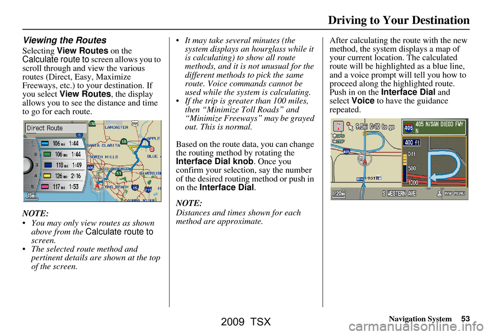
Selecting View Routes on the
Calculate route to screen allows you to
scroll through and view the various
routes (Direct, Easy, Maximize
Freeways, etc.) to your destination. If
you select View Routes , the display
allows you to see the distance and time
to go for each route.
NOTE:
You may only view routes as shown above from the Calculate route to
screen.
The selected route method and pertinent details are shown at the top
of the screen. It may take several minutes (the
system displays an hourglass while it
is calculating) to show all route
methods, and it is not unusual for the
different methods to pick the same
route. Voice commands cannot be
used while the system is calculating.
If the trip is greater than 100 miles, then “Minimize Toll Roads” and
“Minimize Freeways” may be grayed
out. This is normal.
Based on the route data, you can change
the routing method by rotating the
Interface Dial knob. Once you
confirm your selection, say the number
of the desired routing method or push in
on the Interface Dial .
NOTE:
Distances and times shown for each
method are approximate. After calculating the route with the new
method, the system displays a map of
your current locatio
n. The calculated
route will be highlighted as a blue line,
and a voice prompt will tell you how to
proceed along the highlighted route.
Push in on the Interface Dial and
select Voice to have the guidance
repeated.
Driving to Your Destination
2009 TSX
Page 54 of 170

54Navigation System
Driving to Your Destination
Viewing the Destination Map
Selecting View Dest. Map displays a
map of the destination vicinity. Press the
CANCEL or NAVI BACK button to
return. You can view the destination
map anytime while en route by saying,
“Display destination map.”
Map Screen
When you select OK on the Calculate
route to screen, the map screen
appears, showing your highlighted route
in real time.
Route Line
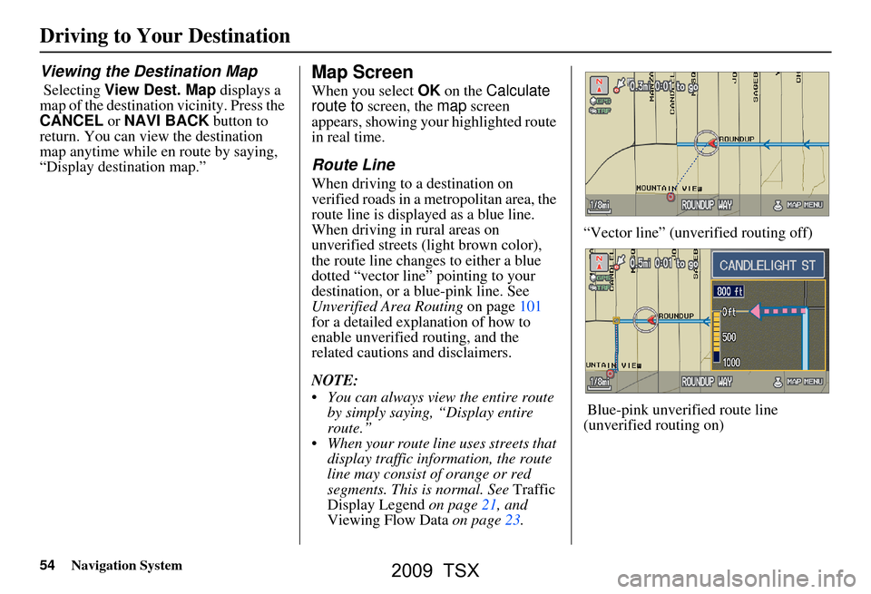
When driving to a destination on
verified roads in a metropolitan area, the
route line is displayed as a blue line.
When driving in rural areas on
unverified streets (light brown color),
the route line changes to either a blue
dotted “vector line” pointing to your
destination, or a blue-pink line. See
Unverified Area Routing on page101
for a detailed explanation of how to
enable unverified routing, and the
related cautions and disclaimers.
NOTE:
You can always view the entire route by simply saying, “Display entire
route.”
When your route line uses streets that display traffic information, the route
line may consist of orange or red
segments. This is normal. See Traffic
Display Legend on page21, and
Viewing Flow Data on page23. “Vector line” (unverified routing off)
Blue-pink unverified route line
(unverified routing on)
2009 TSX
Page 61 of 170

Navigation System61
Map Scale
Rotate the Interface Dial knob or say a voice command such as “Display 1/2 mile scale” (see page 154) to change the scale of
the map. Zooming in increases the detail, while zooming out gives you a view of a wider area. After changing the scale, give th e
system a few moments to update the display.
Functions available at various map scales
NOTE:
You can change between miles or kilometers in SETUP (see Units on page
99).
For information on the available voice commands, see Voice Command Index on page153.
Map Scale (English and Metric)
For selecting uni ts, see page
99.1/20 mi.1/8 mi. 1/4 mi. 1/2 mi. 1 mi. 2 mi. 5 mi. 15 mi. 50 mi. 150 mi. 350 mi.
80 m 200 m 400 m 800 m1.6 km3 km 8 km 24 km 80 km240 km 560 km
POI icon symbols (like ATM) page 63 XX
Breadcrumbs (off-road tracking dots)page69 XXXX
Freeway exit information icons page 63 XXX
One-way traffic icon page
63 X
Unverified road display (light brown)page101 XXX
Map orientation “Heading-up” page 62 XXXXX
Map orientation “North-up” page
62 XXXXXXXXXXX
Map features (like park, golf course)page55 XXXXXXXXXX
Avoid area shown on map page 105 XXX
Avoid area scales (when creating) page
105 XXX
Waypoint “flag” icons page
74 XXXXXXXXXXX
Traffic speed / incident page
21 XXXXXXX
Weather Information page
64 XXXXXXXXXXX
Driving to Your Destination
2009 TSX
Page 70 of 170

70Navigation System
Driving to Your Destination
Viewing/Saving the Current
Location
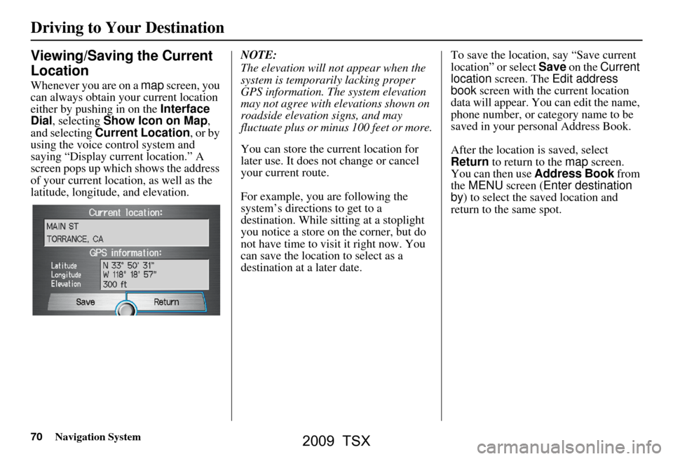
Whenever you are on a map screen, you
can always obtain your current location
either by pushing in on the Interface
Dial , selecting Show Icon on Map ,
and selecting Current Location , or by
using the voice control system and
saying “Display current location.” A
screen pops up which shows the address
of your current location, as well as the
latitude, longitude, and elevation. NOTE:
The elevation will not appear when the
system is temporarily lacking proper
GPS information. The system elevation
may not agree with elevations shown on
roadside elevation signs, and may
fluctuate plus or minus 100 feet or more.
You can store the current location for
later use. It does not change or cancel
your current route.
For example, you
are following the
system’s directions to get to a
destination. While sitting at a stoplight
you notice a store on the corner, but do
not have time to visit it right now. You
can save the location to select as a
destination at a later date. To save the location, say “Save current
location” or select Save
on the Current
location screen. The Edit address
book screen with the current location
data will appear. You can edit the name,
phone number, or category name to be
saved in your personal Address Book.
After the location is saved, select
Return to return to the map screen.
You can then use Address Book from
the MENU screen ( Enter destination
by ) to select the saved location and
return to the same spot.
2009 TSX
Page 84 of 170

84Navigation System
Information Features
Elapsed Time
Shows the elapsed time that the ignition
has been on.
Average Speed
Shows you the averag e speed in miles
per hour (mph) since the trip meter was
last reset.
Range
Shows the estimated distance you can
travel on the fuel remaining in the tank.
This distance is estimated from the
average fuel economy over the last
several miles, so it will vary with
changes in speed, traffic, etc.
NOTE:
Information from the Trip Computer will be displayed only when the
ignition is on.
The “Instant Fuel” and “Average Fuel” may vary from actual fuel
consumed. These values are estimates
only.
The “Range” is only an estimate. Always monitor your vehicle’s fuel
gauge to determine the appropriate
time to refuel.Cellular Phonebook
The Cellular Phonebook option
allows you to store up to 1,000 names
and 10,000 phone numbers in the
phonebook of Bluetooth®
HandsFreeLink® (HFL) from your
cellular phonebook. With the HFL, you
can then automatically dial any name or
number in the phonebook.
Say or select Cellular Phonebook
from the INFO screen ( Main Info ), and
the display changes to:
NOTE:
For more information on this feature, see your vehicle Owner’s manual.
For questions about the HFL Cellular Phonebook, call HandsFreeLink
customer support at 1-888-528-7876.
Calendar
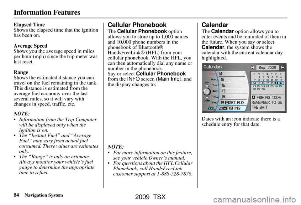
The Calendar option allows you to
enter events and be reminded of them in
the future. When you say or select
Calendar , the system shows the
calendar with the current calendar day
highlighted.
Dates with an icon indicate there is a
schedule entry for that date.
2009 TSX
Page 101 of 170

Navigation System101
System Setup
Unverified Area Routing
Allows you to receive turn-by-turn ma p and voice guidance in unverified areas when en route to a destination (see Map Overview
on page6). The chart below illustrates th e routing differences with this setting ON or OFF .
Unverified Area Routing: OFF (factory default) Unverified Area Routing: ON
Decision:
Why choose
ON or OFF ?
The driver wishes to navigate manually by using the
navigation map and choosing th e streets that lead to the
destination. The driver un derstands that unverified
roads may not be accurate, and can contain errors in
location, naming, and address range. The driver chooses to let th
e navigation system suggest
possible routing. The driver understands that in some
cases, guidance may not be appropriate. Unverified
roads may not be accurate, and can contain errors in
location, naming, and address range.
What you will
see...A blue dotted vector line is displayed on the map that
continually points to your destination. The driver
should stop and then use the map to select streets that
lead to the destination. A blue-pink dashed route line highlights suggested
unverified streets on the ma
p while traveling to your
destination. This is in sharp contrast to the normal blue
route line displayed in verified areas.
Cautionary
messagesThere are cautionary pop-up screens and voice
announcements, before and during the route. These
serve as reminders that you should obey all traffic
restrictions. There are cautionary pop-
up screens and voice
announcements, before and during the route. These
serve as reminders that you should exercise additional
caution, and obey all traffic restrictions.
Guidance
(map/voice)There is no turn-by-turn map or voice guidan ce. Voice guidance commands end with the words “if
possible.” This is to remind the driver to verify all
traffic restrictions before making a maneuver.
Directions listA direction list is typically not available. However,
depending on your route, directions are provided to
help you reach the first available verified road. A direction list is provided showing street names and
turn symbols in pink.
2009 TSX
Page 102 of 170

102Navigation System
System Setup
Unverified Area Routing
When driving to your destination, you
have the choice of using or not using
“unverified” roads. You make this
choice in the SETUP screen. The next
few pages contain an example of a route
to a destination in an unverified area
explaining the routing differences found
in unverified areas.
With Unverified Area Routing OFF ,
the system tries to use verified roads
whenever possible. In this example,
since only verified streets are used, it
created a longer rout e than necessary.
With Unverified Area Routing ON ,
the route is shorter, but consists of
unverified (light colored) streets that
may not be accurate. Because the streets
are unverified, there may be errors in
street location, name, or address range.
Additional caution is recommended in
these areas. Always obey posted traffic
restrictions. Because both routes bypass or use
unverified streets, an initial
Disclaimer
screen is provided. It is recommended
that you stop and review the map.
Unverified Area Routing “OFF” Unverified Area
Routing “ON”
NOTE:
Unverified roads are shown only when
viewing the map in the 1/20, 1/8, and
1/4 mile map scales, or the 80, 200, and
400 meter map scales.
2009 TSX