Page 137 of 172
Coverage Areas
Navigation System137
Niagara
Fort Erie
Grimsby
Lincoln
Niagara-on-the-Lake
Niagara Falls
Pelham
Port Colborne
St Catharines
Thorold
Wa i n fl eet
Wel l a n d
We s t L i n c ol n
Peel Brampton
Caledon
Mississauga Simcoe
Adjala-Tosorontio
Bar rie
Bradford West Gwillimbury
Clearview
Essa
Innisfi l
Midland
New Tecumseth
Orillia
Oro-Medonte
Penetanguishene
Ramara
Severn
Springwater
Tay
Tiny
Wa s a g a B e a c h
To r o n t o To r o n t o
Waterloo Cambridge
Kitchener
North Dumfries
Wa t e r l o o Wel l i ngt on
Guelph
Puslinch
Yo r k Aurora
East Gwillimbury
Georgina
King
Markham
Newmarket
Richmond Hill
Va u g h a n
Whitchurch-Stouffville
Essex Lasalle
Te c u m s e h
Windsor
Inter-Town (partial) Coverage
Counties /Districts / Regional
Municipalities
Brant
Bruce
Chatham-Kent
Dufferin
Elgin
Essex
Frontenac
2009 TL
Page 138 of 172

Coverage Areas
138 Navigation System
Gray
Haldimand-Norfolk
Haliburton
Hastings
Huron
Kawartha Lakes
Lambton
Lanark
Leeds and Granville
Lennox and Addington
Middlesex
Muskoka
Northumberland
Oxford
Perth
Peterborough
Prescott and Russell
Prince Edward
Simcoe
Stormont, Dundas and Glengarry
Wa t e r l o o
Wellington
QUÉBEC
Municipalites Regionales de Comte Beauharnois-Salaberry
Brome-Missisquoi
Coaticook
La Haute-Yamaska
La Vallee-du-Richelieu Le Haut-Richelieu
Le Haut-St-Laurent
Les Jardins-de-Napierville
Memphremagog
Roussillon
Rouville
Vaudreuil-Soulanges
Deux-Montagnes Deux-Montagnes
Oka
Oka Paroisse
Pointe-Calumet
St-Eustache
St-Joseph-du-Lac
Ste-Marthe-sur-le-Lac
L’assomption Charlemagne
Le Gardeur
Repentigny
La Rivìere-du-Nord Prévost
St-Colomban
St-Hippolyte
St-Jèrôme
Ste-Sophie La Vallee-du-Richelieu
Beloeil
Carignan
Chambly
Longueuil
McMasterville
Mont-St-Hilaire
Otterburn Park
St-Basile-le-Grand
St-Mathieu-de-Beloeil
LaJemmerais Longueuil
Ste-Julie
Laval Laval
Les Laurentides Amherst
Arundel
Barkmere
Brèbeuf
Huberdeau
La Conception
La Minerve
Labelle
Lac-Supèrieur
Lantier
Mont-Tremblant
Montcalm
2009 TL
Page 139 of 172

Coverage Areas
Navigation System139
St-Faustin-Lac-Carrè
Ste-Agathe-des-Monts
Ste-Lucie-des-Laurentides
Va l - D a v i d
Va l - d e s - L a c s
Va l - M o r i n
Les Moulins Lachenaie
Mascouche
Te r r e b o n n e
Les Pays-D’en-Haut Lac-des-Seize-Îles
Morin-Heights
Piedmont
Ste-Adolphe-d’Howard
St-Sauveur
Ste-Adèle
Ste-Anne-des-Lacs
Ste-Marguerite-Estèrel
We n t wo r t h - No r d
Longueuil Longueuil
Montréal Montréal
Rousillon
Candiac
Châteauguay
Delson
La Prairie Léry
Ste-Catherine
St-Constant
Therese-de-Blainville Bla inville
Boisbriand
Bois-des-Filion
Lorraine
Rosemere
Ste-Thérèse
Va u d r e u i l - S o u l a n ge s Hudson
L’ I l e - C a d i e u x
L’ I l e - P e r r o t
Notre-Dame-de-l’Ile-Perrot
Pincourt
St-Lazare
Te r r a s s e -Va u d r e u i l
Va u d r e u i l - D o r i o n
Va u d r e u i l - s u r- l e - L a c
Québec Québec
SASKATCHEWAN Regina
Saskatoon CANADA CONNECTOR ROADS
The Cross-Canada Connector Road
allows for travel between the provinces
of British Columbia and Quebec in
DCA 11. Major metropolitan city Points
of Interest are also included.
Road Inclusion
Roads in the province of British
Columbia
Hwy-1/Trans Canada Hwy from
Alberta/BC boundary to Vancouver
detailed city
Hwy-3 / Crowsnest Hwy from Hwy-1/ Trans Canada Hwy (Hope) to Hwy-5/
Coquihalla Hwy (Hope)
Hwy-5/Coquihalla Hwy (in Hope) to Hwy-1/Trans Canada Hwy (in
Kamloops)
Hwy-99 between Vancouver and Whistler
2009 TL
Page 140 of 172

Coverage Areas
140 Navigation System
Roads in the province of Alberta
Hwy-1/Trans Canada Hwy across whole
province
Hwy-1A from Cochrane to Canmore
Hwy-1X from Hwy-1A to Hwy-1/ Trans Canada Hwy
Morley Road from Hwy-1/Trans Canada Hwy
Hwy-3/Crowsnest Hwy (at Medicine Hat) to Lethbridge
Hwy-4 (at Lethbridge) to 1-15 (U.S. border)
Hwy-36 between Hwy-3 (in Taber) and Hwy-4 (in Warner)
Hwy-3/Crowsnest Hwy (in Lethbridge) to Hwy-2 (in Fort Macleod)
Hwy-2 (in Fort Macleod) to Hwy-1/ Trans Canada Hwy (in Calgary)
Roads in the province of Saskatchewan
Hwy-1/Trans Canada Hwy across whole province Roads in the province of Manitoba
Hwy-1/Trans Canada Hwy across whole
province
Hwy-100/Trans Canada Hwy in Winnipeg (partial beltway)
Hwy-75 from Hwy-100/Trans Canada Hwy (Winnipeg) south to link with
1-29 ( U. S. b ord er)
Roads in the province of Ontario
Hwy-69/Trans Canada Hwy from Muskoka district to Sudbury
Hwy-17/Trans Canada Hwy from Ottawa Detailed Area Coverage to
Manitoba border
Hwy-17B at Sault Ste Marie to link with 1-75 (U.S. border)
Hwy-61 from Hwy-17 at Thunder Bay to link with US-61 (U.S. border)
Hwy-11 from Muskoka district to North Bay
Hwy-60 and Hwy-127 in Nipissing County Cities with available real-time in-car
traffi
c information
The following cities currently have
available real-time traffi c information.
In the U.S. Albany-Schenectady-Troy, NY
Albuquerque, NM
Allentown-Bethlehem, PA
Atlanta, GA
Austin, TX
Baltimore, MD
Bir m ingham, A L
Boston, MA
Buffalo-Niagara Falls, NY
Charlotte-Gastonia-Rock Hill, NC
Chicago, IL
Cincinnati, OH
Cleveland, OH
Colorado Springs, CO
Columbus, OH
Dallas-Ft. Worth, TX
Dayton, OH
Denver-Boulder, CO
Detroit, MI
Fresno, CA
Grand Rapids, MI
Gr eensboro-Winston Salem-High Point, NC
Greenville-Spartanburg, SC
Harrisburg-Lebanon-Carlisle, PA
2009 TL
Page 141 of 172

Coverage Areas
Navigation System141
Hartford-New Britain-Middletown, CT
Houston-Galveston, TX
Indianapolis, IN
Jacksonville, F L
Kansas City, KS
Lancaster-York, PA
Las Vegas, NV
Lincoln, NE
Little Rock, AR
Los Angeles, CA
Louisville, KY
Memphis, TN
Miami-Ft. Lauderdale-Hollywood, FL
Milwaukee-Racine, WI
Minneapolis-St. Paul, MN
Mobile, AL
Naples-Ft. Myers, FL
Nashville, TN
New Orleans, LA
New York, NY
No rfolk-Virginia Beach-Newport
News, VA
Oklahoma City, OK
Omaha-Council Bluffs, NE
Orlando, FL
Philadelphia, PA
Phoenix, AZ
Pittsburgh, PA
Portland, OR
Portsmouth-Manchester, NH Providence-Warwick-Pawtucket, RI
Raleigh-Durham, NC
Richmond, VA
Rochester, NY
Sacramento, CA
Salt Lake City, UT
San Antonio, TX
San Diego, CA
San Francisco-Oakland, CA
San Jose, CA
Sarasota-Bradenton, FL
Seattle-Tacoma, WA
Spokane, WA
Springfi
eld, MA
St. Louis, MO
Syracuse, NY
Tampa-St. Petersburg-Clearwater, FL
To l e d o , O H
Tu c s o n , A Z
Tu l s a , O K
Washington, DC
West Palm Beach-Boca Raton, FL
Wilkes Barre-Scranton, PA
Wilmington, DE
In Canada To r o n t o , O N
Montreal, QB
Va n c o u v e r, B C Coverage may expand to other
cities as traffi
c information in
those cities becomes available. For
the latest traffi c coverage details
for each metropolitan area, check
www.acura.com /realtimetraffi c . This
site provides traffi c coverage for each
city, a demonstation video, and FAQs.
2009 TL
Page 142 of 172

Coverage Areas
142 Navigation System
Operation in Alaska, Hawaii,
Canada, and Puerto Rico
Certain functions that rely on a satellite
signal will not work correctly. These
functions include but are not limited to
AcuraLink, NavTraffi c and Weather.
XM Radio
Navigation-equipped veh icles delivered
to Alaska, Hawaii, Canada, and
Puerto Rico are equipped with XM
hardware, but XM broadcasting is
not available; therefore sections of
the manual that mention XM audio,
traffi c displays, weather information,
and AcuraLink features do not apply.
Vehicles originally delivered to the U.S.
mainland and shipped to Hawaii also
have XM, but will not function because
the XM satellites (aimed toward the
U.S. mainland) are too far away to
obtain reception.
Alaska, Hawaii, Canada, and
Puerto Rico
This section describes the differences in
navigation system operation for vehicles
delivered in Alaska, Hawaii, Canada,
and Puerto Rico.
Map Coverage
All roads displayed on the map screens
are detailed coverage roads. Text related
to “unverifi ed” roads or areas are not
applicable. The following topics do not
apply:
• Unverifi ed road descriptions (see
page 7, 103 )
• Cautions and pop-up windows related to unverifi ed roads (see page 72 )
• Setup entries that relate to turning on or off unverifi ed routing (see page
10 4 )
Other Map Issues
• See the coverage section for a list of
islands with coverage (see page 131 )
Address and POI Entry Screens
The following differences occur for
map, address, and POI selection:
• Entry of a destination address or POI on an island other than your current
island may result in a screen caution
message. This is normal because
there are no “ferry” routes between
islands available in the database.
Setup Screen Differences
The SET UP screen differences are
minor and are listed below. See the
Setup section (pag e 93 ) for additional
information.
2009 TL
Page 143 of 172
 because XM is not
available.
Traffi c & Weather Status
This item is grayed out on th")
Coverage Areas
Navigation System143
AcuraLink / Messages
This item is grayed out on the SET UP
screen ( Other) because XM is not
available.
Traffi c & Weather Status
This item is grayed out on the SET UP
screen ( Other) because XM is not
available.
Puerto Rico
If Street Name Guidance is set to
ON , the street names will not be read
out by voice guidance. This may change
with future data updates.
INFO Screen Differences
Messages
The INFO screen Messages feature
utilizes XM. Because XM is not
available, it is not displayed on the
INFO screen except messages such
as the diagnosis information for the
trouble of the car. In addition, the “Map menu” item New Messages
will
appear grayed out except messages such
as the diagnosis information for the
trouble of the car. This is normal.
Traffi c Incidents
This item is grayed out on the INFO
screen because XM is not available.
Weather Information
This item is grayed out on the INFO
screen because XM is not available.
Map Legend
The map legend “Traffi c” and
“Weather” descriptions may be
available, but do not apply.Shipping a Vehicle To or From
Alaska, Hawaii, Canada, and
Puerto Rico
Although the HDD in the vehicle
contains maps for both U.S. mainland
and Hawaii, the dealer must perform
the selection of “U.S. mainland” or
“Hawaii” for you. NOTE:
Shipping a vehicle from Alaska,
Hawaii, Canada, and Puerto Rico to
the U.S. mainland
• If you wish to receive XM audio,
traffi c, or weather, you must call XM
and set up an account at (800) 852-
9696.
• To begin receiving AcuraLink quick tips, contact Acura Client Services
at (800) 382-2238, and ask them to
activate your AcuraLink unit.
Shipping a vehicle from the U.S.
mainland to Alaska, Hawaii, Canada,
and Puerto Rico
• If a U.S. mainland-delivered vehicle is shipped to Alaska, Hawaii,
Canada, and Puerto Rico, there is no
XM reception.
• The issues under “Operation in Alaska, Hawaii, Canada, and Puerto
Rico” apply.
2009 TL
Page 144 of 172

Frequently Asked Questions
144 Navigation System
Map and Features, Voice Operation, Entering Addresses
Problem Solution
Why does the Disclaimer screen need to be displayed
every time I start the car? I am the only driver. The
Disclaimer screen reminds you and your guest drivers to always operate
the navigation system in a safe manner.
I tried entering an address, but the city or street could
not be found. Is there any other way to route to the
location? Some cities are lumped in with a major metro area. Try entering the street
fi
rst. In rural “unverifi ed” areas or new subdivisions, streets may be missing,
or only partially numbered. Try selecting the destination directly from the
map. See By Map Input on page 46 .
When I enter an address, some letters become grayed
out. Is this normal? Yes. As you enter each letter in an address or a point of interest (POI), the
system looks in the database to see what letters are possible and “grays out”
letters that do not apply.
How do I delete Personal Addresses, Previous
Destinations, or the Home Address? This is done in the
SET UP screen (Main Set up ), under “Personal
Information.” See pag e 94 .
I cannot hear the navigation system voice. 1) E n su r e t hat Volum e in the SET UP screen ( Main Set up) is not OFF.
See pag e 94 .
2) Go to “Basic Settings” in the SET UP screen (Other), and set Voic e
Recognition Feedback to ON . See pag e 102 .
The voice control system is having diffi culty recognizing
my voice commands. Ensure that the vents are not blowing on the microphone on the ceiling, the
vehicle is as quiet as possible, and you are using the correct command when
speaking (see
Improving Voice Recognition on page 14 ). Say “Help” at any
screen to see a list of the applicable voice commands. If the system cannot
recognize your command because of background noise, speak louder.
When the system pronounces the street name in the
guidance command or reads the destination address, it
sounds strange. What causes this? The basic guidance phrase uses a studio-recorded voice, but the street name
is pronounced by the system using a machine-generated voice. Consequently,
the name may be mispronounced or sound strange at times.
When I drive at night, the screen is bright and will not
switch to the night display mode. Why? Verify the following: The nighttime dash brightness control is not set to
maximum, and Map Color in SET UP is set to Black
for Night. See
Switching Display Mode Manually on page 115 .
Frequently Asked Questions
2009 TL
 1
1 2
2 3
3 4
4 5
5 6
6 7
7 8
8 9
9 10
10 11
11 12
12 13
13 14
14 15
15 16
16 17
17 18
18 19
19 20
20 21
21 22
22 23
23 24
24 25
25 26
26 27
27 28
28 29
29 30
30 31
31 32
32 33
33 34
34 35
35 36
36 37
37 38
38 39
39 40
40 41
41 42
42 43
43 44
44 45
45 46
46 47
47 48
48 49
49 50
50 51
51 52
52 53
53 54
54 55
55 56
56 57
57 58
58 59
59 60
60 61
61 62
62 63
63 64
64 65
65 66
66 67
67 68
68 69
69 70
70 71
71 72
72 73
73 74
74 75
75 76
76 77
77 78
78 79
79 80
80 81
81 82
82 83
83 84
84 85
85 86
86 87
87 88
88 89
89 90
90 91
91 92
92 93
93 94
94 95
95 96
96 97
97 98
98 99
99 100
100 101
101 102
102 103
103 104
104 105
105 106
106 107
107 108
108 109
109 110
110 111
111 112
112 113
113 114
114 115
115 116
116 117
117 118
118 119
119 120
120 121
121 122
122 123
123 124
124 125
125 126
126 127
127 128
128 129
129 130
130 131
131 132
132 133
133 134
134 135
135 136
136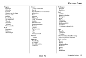 137
137 138
138 139
139 140
140 141
141 142
142 143
143 144
144 145
145 146
146 147
147 148
148 149
149 150
150 151
151 152
152 153
153 154
154 155
155 156
156 157
157 158
158 159
159 160
160 161
161 162
162 163
163 164
164 165
165 166
166 167
167 168
168 169
169 170
170 171
171